Abandoned & Little-Known Airfields:
Western Kentucky
© 2003, © 2024 by Paul Freeman. Revised 7/12/24.
This site covers airfields in all 50 states: Click here for the site's main menu.
____________________________________________________
Please consider a financial contribution to support the continued growth & operation of this site.
Camp Breckenridge AAF / Morganfield Airport (revised 9/25/22) - Farrington Airpark (revised 12/17/23) - Original Hancock County Airport (revised 12/18/23)
Hardin County / Elizabethtown Airport (revised 8/12/15) – Paducah Airport / Howell Field (revised 7/12/24) – Russell Springs Airport / Original Russell County Airport (revised 12/17/23) - West Point Airport (revised 12/17/23)
____________________________________________________
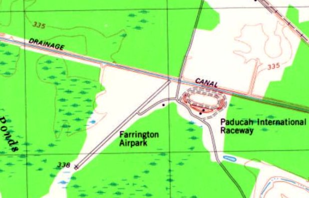
Farrington Airpark (KY29), Paducah, KY
36.968, -88.565 (Southeast of St. Louis, MO)
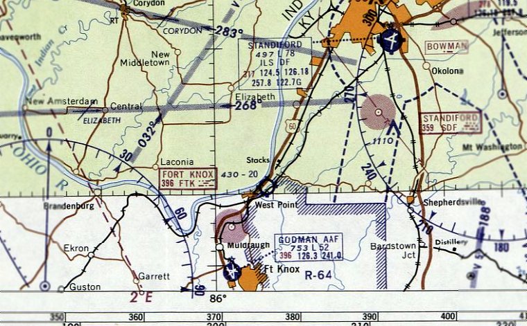
Farrington Airpark, as depicted on the 1982 USGS topo map.
A 1968 aerial photo did not yet show anything developed at this location, just fields & wooded land.
According to Drag Illustrated, McCracken County Drag Strip, a quarter-mile NHRA facility, was constructed at this location in 1968.
Nothing at this location (neither runway nor dragstrip) was depicted on the 1968 or 1970 USGS topo maps.
According to Drag Illustrated, the McCracken County Drag Strip “lasted close to a decade before being shut down & completely converted to an airport in 1977.”
According to Malcolm Dickinson, “The dragstrip was bought by Don Farrington, a retired Pan Am captain who was also a flight instructor in gyroplanes & helicopters.
He converted it into a privately-owned, public-use airport with one paved, lighted runway (2,904' Runway 4/22) and several hangars.
Farrington installed an Non-Directional Beacon on the field, and was able to use it to develop a rudimentary approach procedure that could be used during periods of lower visibility.
Farrington Airpark was the home of Farrington Aircraft, a venture dedicated to purchasing the tooling & type certificate of the Air & Space 18A certificated gyroplane,
and also developing the Farrington TwinStar, an open-cockpit experimental gyroplane which was manufactured on site.
Farrington, along with flight instructor John Potter, conducted training for those wishing to add gyroplane rating to their private, commercial, and CFI certificates.”
The earliest depiction which has been located of Farrington Airpark was a 1981 aerial view.
It depicted Farrington Airpark as having a single paved Runway 4/22, with a few small buildings & 2 light single-engine aircraft on the northeast side.
The earliest depiction which is available of Farrington Airpark was on the 1982 USGS topo map.
It depicted Farrington Airpark as having a single paved northeast/southwest runway, with 1 small building on the east side.
A 1983 aerial view showed a larger hangar had been added on the east side of Farrington Airpark at some point between 1981-83,
and the number of light aircraft parked on the field had increased to 6.

A Spring 1996 photo of Malcolm Dickinson & John Potter in front of an Air & Space 18A gyroplane at Farrington Airpark.
Malcolm recalled, “I attended 8 days of training here in the spring of 1996 and will never forget flying the 18A & the TwinStar with John & Don.”
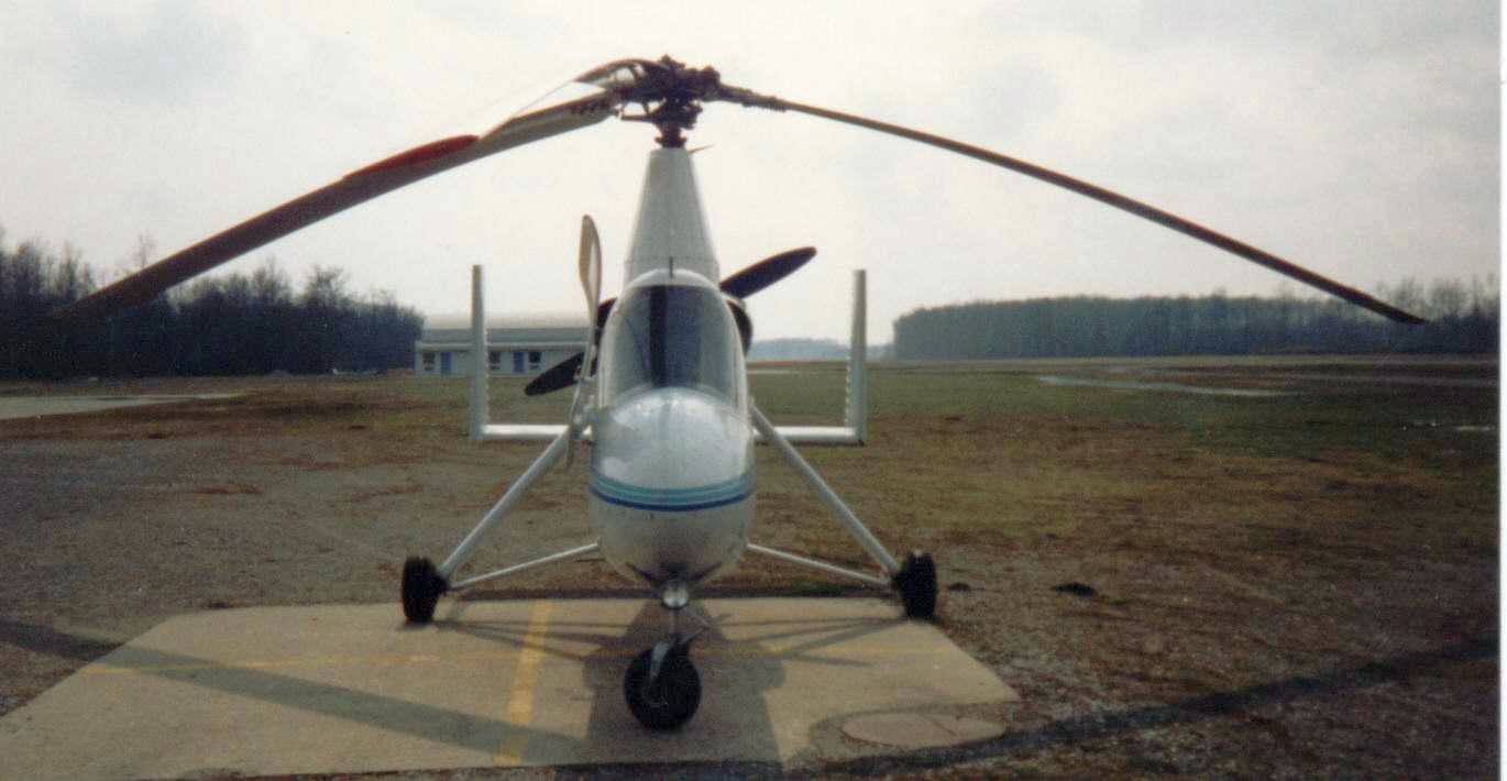
A Spring 1996 photo by Malcolm Dickinson of an Air & Space 18A gyroplane at Farrington Airpark.
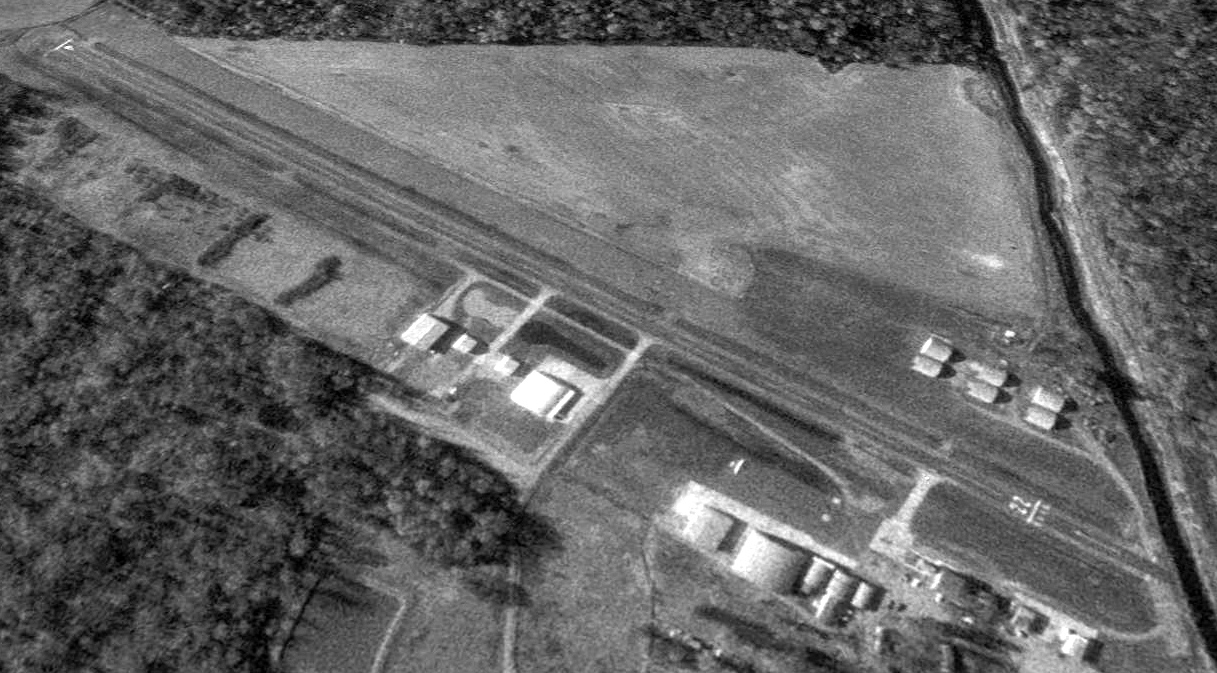
The earliest aerial photo which is available of Farrington Airpark was a 1998 USGS aerial view looking west.
It depicted Farrington Airpark as having a single paved Runway 4/22, with several hangars along the east side, and 1 light single-engine aircraft.
According to Malcolm Dickinson, “Don Farrington died of a heart attack in April 2000. The airport closed sometime after that.”
According to Drag Illustrated, “The rebirth of the drag strip happened after local businessman & racer, Keith Murt, bought the property in 2012
and reopened the drag strip [Beacon Dragway] the following year after an extensive 12-month remodeling period.”
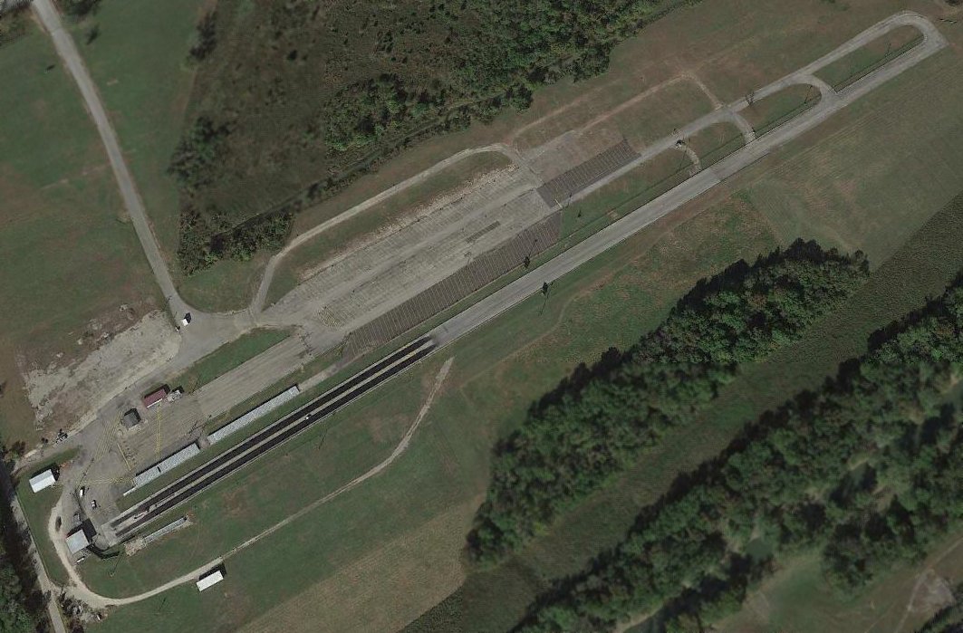
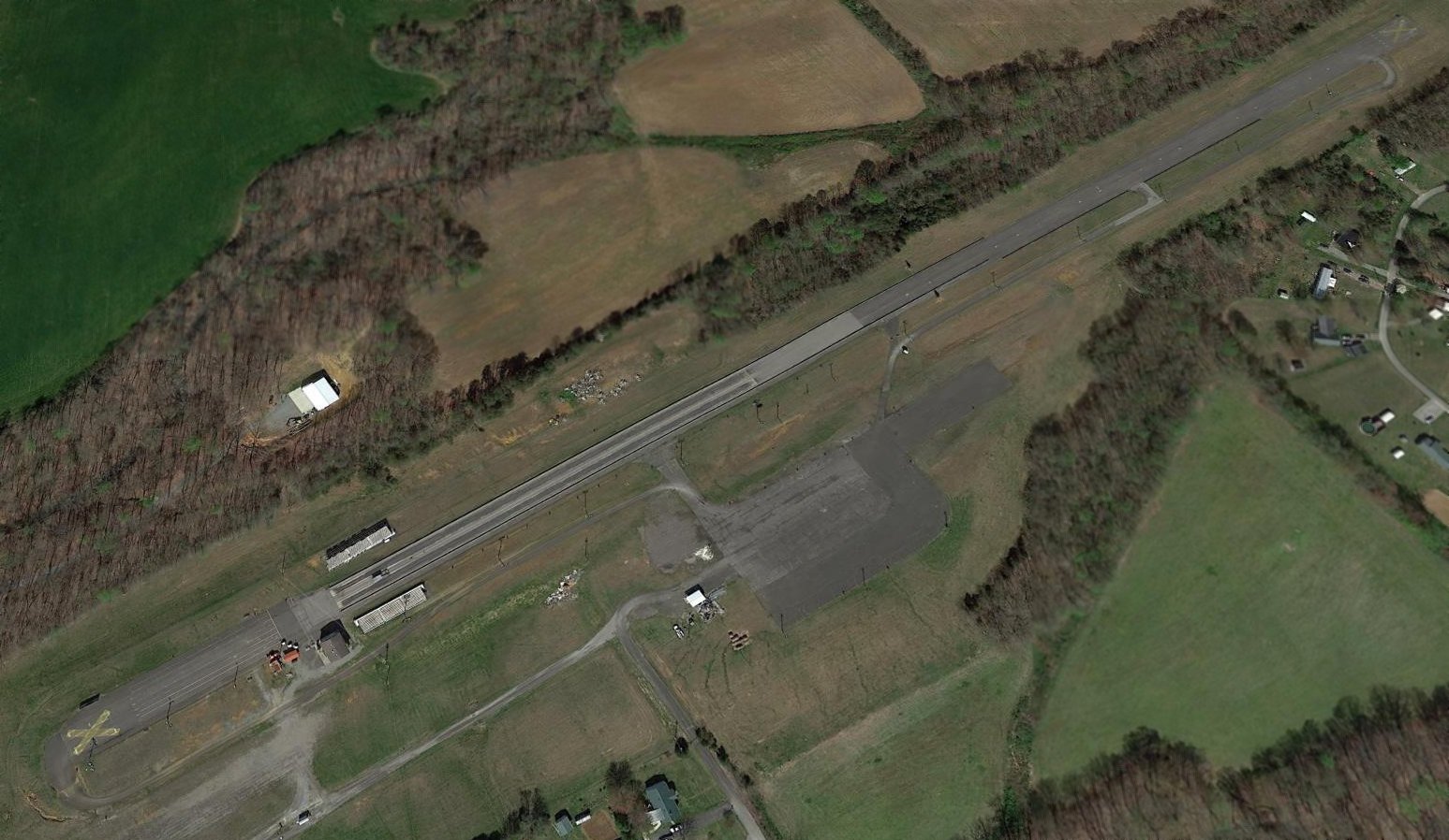
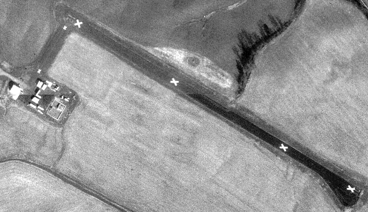
A 2015 aerial view looking west at the site of Farrington Airpark showed the runway & hangars remained intact, reused as a drag strip.
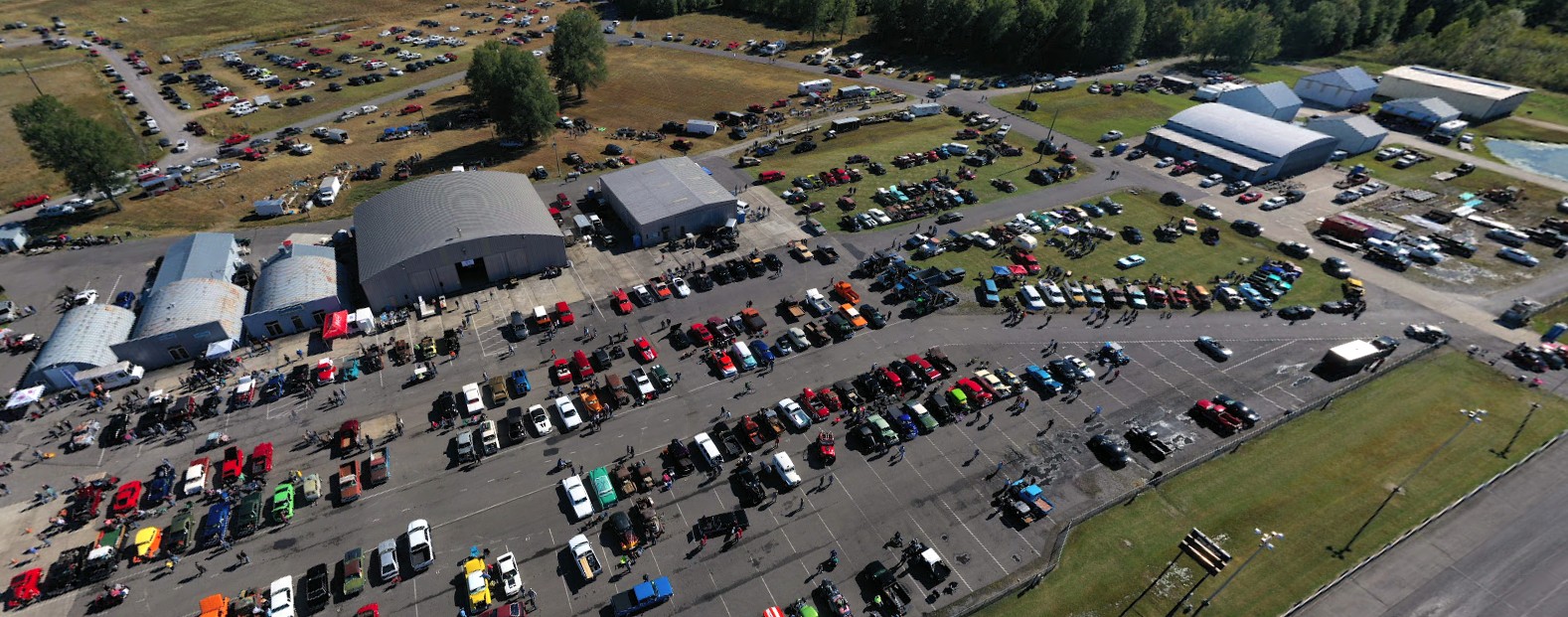
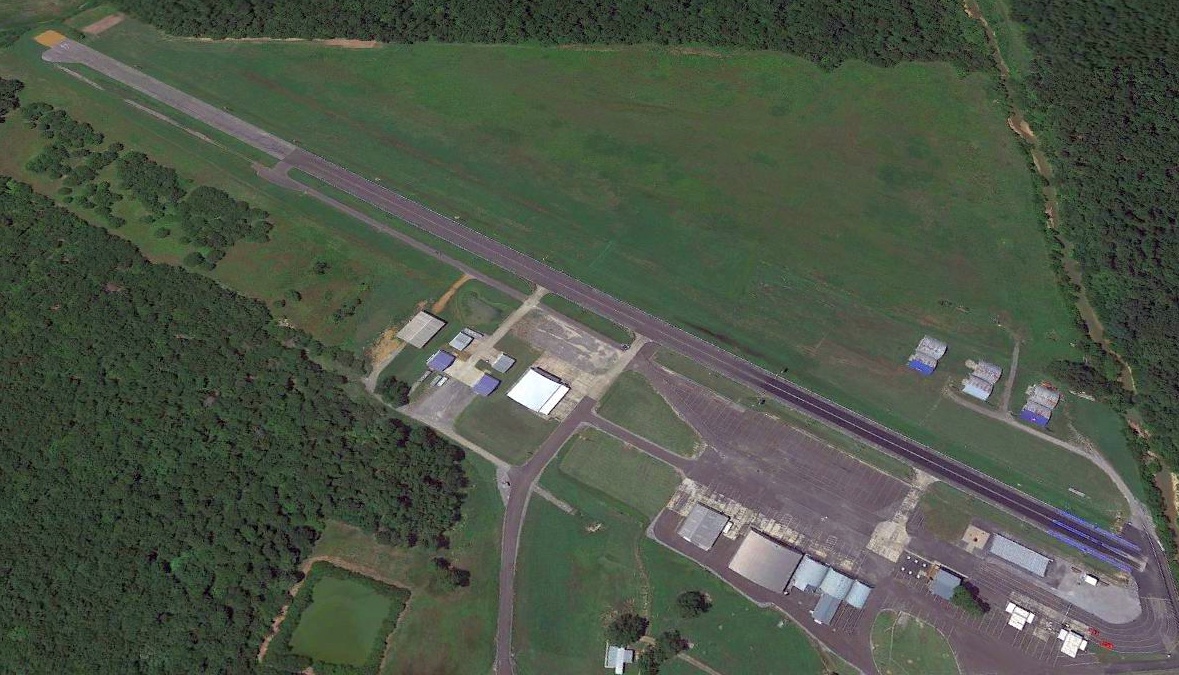
A 2019 aerial view looking southeast showed the former hangars remaining along the east side of the Farrington Airpark site, with a large number of cars present for an event.
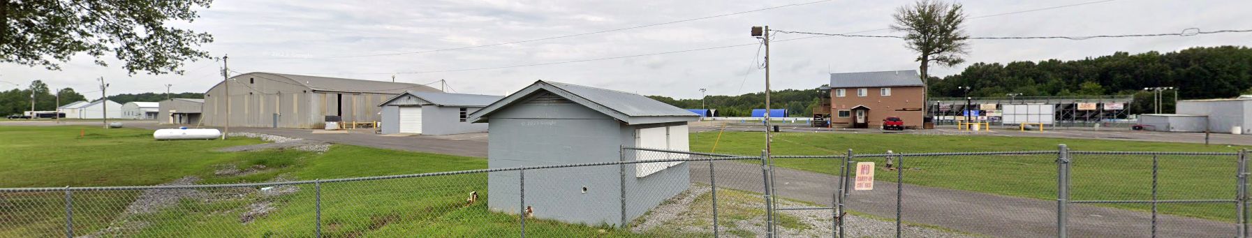
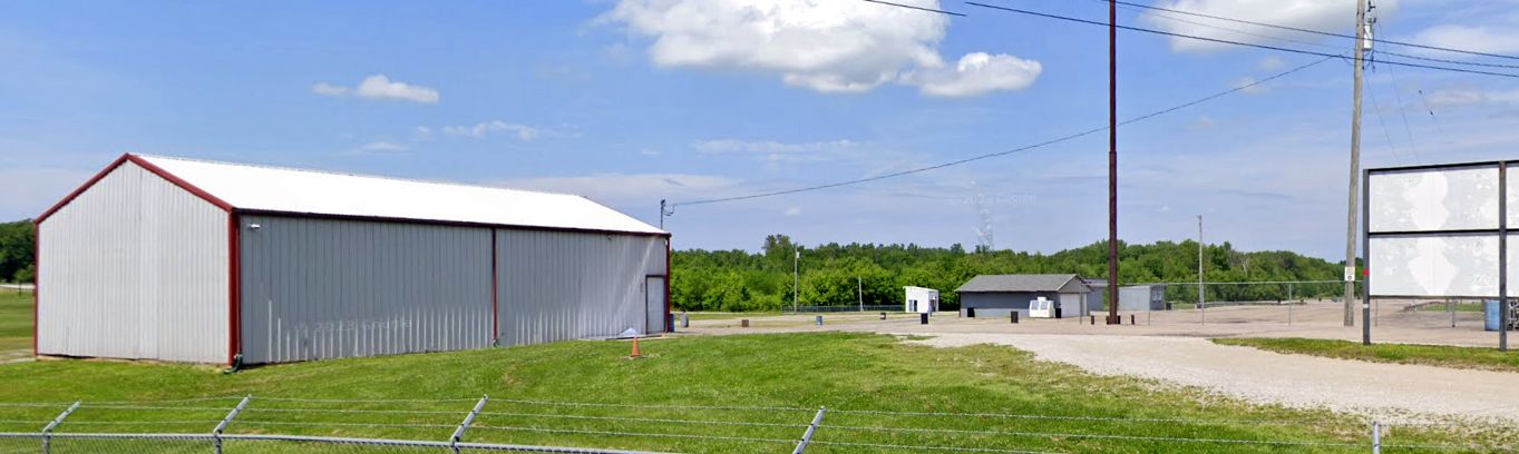
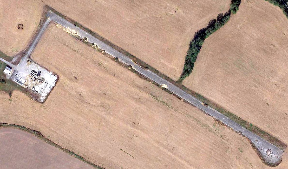
A 2023 photo looking west at the former hangars remaining along the east side of the Farrington Airpark site.
Thanks to Malcolm Dickinson for pointing out this airfield.
____________________________________________________
West Point Airport, West Point, KY
38.005, -85.932 (Southwest of Louisville, KY)
West Point Airport, as depicted on the April 1947 Cincinnati Sectional Chart.
West Point Airport was evidently established at some point between 1946-47,
as it was not yet depicted on the October 1946 Cincinnati Sectional Chart.
The earliest depiction which has been located of West Point Airport was on the April 1947 Cincinnati Sectional Chart.
It depicted West Point Airport as a commercial/municipal airport.
The 1950 USGS topo map depicted “West Point Landing Field (Private)” as an open area with a few small buildings on the west side.
The earliest photo which has been located of West Point Airport was a 1955 aerial view.
It depicted West Point Airport as having a northeast/southwest grass runway,
with 6 light planes parked near a few small buildings on the west side.
A 1959 aerial view depicted West Point Airport in an unchanged fashion.
The 1959 USGS topo map depicted “West Point Landing Field” in the same manner as on the 1950 USGS topo map.
Brennan Callan reported, “In 2019, I was at the West Point museum & I saw they had photos of the former airport which is now used as a car racetrack.
This field was used for both general aviation & military aviation as the Headquarters for Fort Knox was at West Point, KY itself.
They had dirigibles at this field as well as traditional planes.”
The last depiction which has been located of West Point Airport was on the January 1960 Cincinnati Sectional Chart.
It depicted West Point Airport as having a 2,000' unpaved runway.
West Point Airport was evidently closed (for reasons unknown) at some point in 1960,
as it was no longer depicted on the June 1960 Cincinnati Sectional Chart or the 1961 USGS topo map.
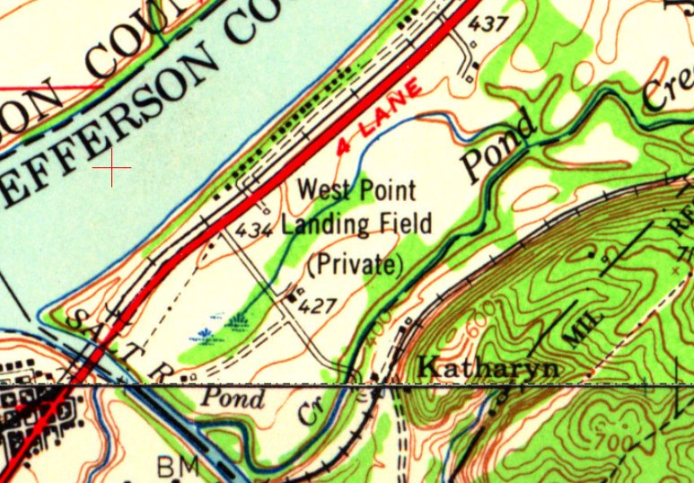
A 1971 aerial photo depicted an automobile drag strip having been constructed on the site of West Point Airport.
Although the dragstrip pavement looks like a former runway, apparently the West Point Airport runway was always unpaved,
and the paved surface was added after the airport's closure, purpose-built as a dragstrip.
The 1981 USGS topo map depicted a “Drag strip” on the site of West Point Airport.
A 2018 aerial view looking northwest at the site of West Point Airport showed the Ohio Valley Dragway which occupies the site.
Evidently some of the small buildings on the west side may date to the property's airport days.
As of 2020, street maps label the site of West Point Airport as the Ohio Valley Raceway.
A 2023 photo view looking northeast at the building on the west side of the West Point Airport site. The smaller building to the right may be a former hangar.
Thanks to Brennan Callan for pointing out this airfield.
____________________________________________________
Russell Springs Airport / Original Russell County Airport, Russell Springs, KY
37.022, -85.089 (Southeast of Louisville, KY)
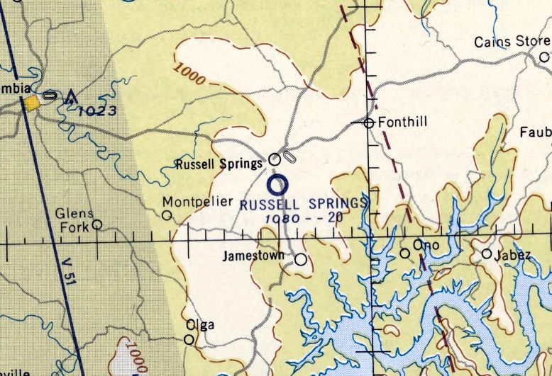
Russell Springs Airport, as depicted on the June 1956 Nashville Sectional Chart.
Russell Springs Airport may have been established at some point in 1956,
as it was not yet depicted on the December 1955 Nashville Sectional Chart nor on a 1956 aerial photo.
The earliest depiction which has been located of Russell Springs Airport was on the June 1956 Nashville Sectional Chart.
It depicted Russell Springs as having a mere 2,000' paved runway.
Russell Springs Airport was not yet depicted on the 1970 USGS topo map.
The earliest photo which has been located of Russell Springs Airport was on a 12/2/72 USGS aerial photo.
It depicted Russell Springs as having a paved Runway 18/36, with 6 light single-engine aircraft parked near a few small buildings on the south side.
Russell Springs Airport was evidently renamed Russell County Airport at some point between 1956-74,
as the 1974 USGS topo map depicted Russell “County Airport” as having a single paved north/south runway, with 2 small buildings on the southeast side.
A 1985 aerial photo showed Russell County Airport's ramp on the southeast side had been replaced at some point between 1972-85 by a ramp on the east side of the runway midpoint,
on which were parked 4 light single-engine planes.
The 1986 USGS topo map depicted Russell “County Airport” as having a single paved north/south runway.
The last photo which has been located showing the original Russell County Airport was a 1987 aerial view, which showed 4 light single-engine planes parked on the east ramp.
In January 1994 a larger Russell County Airport (K24) was opened a mile to the southwest,
at which point the original Russell County Airport was presumably closed.
A 1997 aerial view looking northwest showed the original Russell County Airport after its closure, remaining intact, but with the runway marked with closed-runway “X” symbols.
A 2004 aerial photo showed that at some point between 1997-2004, the former runway of the original Russell County Airport was reused as the Lake Cumberland Dragway.
A 2016 aerial view looking northwest at the site of the original Russell County Airport showed the closed-runway “X” symbols still visible at each runway end.
The middle portion of the runway had been reused as the 1/8 mile Lake Cumberland Dragway.
The site of the original Russell County Airport is located northeast of the intersection of Sherry Lane & Airport Road, appropriately enough.
Thanks to Ron Plante for pointing out this airfield.
____________________________________________________
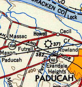
Paducah Airport / Howell Field, Paducah, KY
37.09, -86.67 (Southwest of Louisville, KY)
Paducah Airport, as depicted on the September 1935 Nashville Sectional Chart.
According to the program for the 1949 rededication of Barkley Field (courtesy of Christopher Brame), "In 1932 the city acquired its first municipal airfield.
Congress had allocated limited funds to improve city airports, as part of the old civil works relief program.
Local fliers & civic leaders obtained some of those funds.
A 55-acre tract on the Coleman Road was chosen & Mayor E. G. Scott's administration bought the ground for $1,200
and obtained about $6,000 in federal funds to improve it.
Richard LeRoy was a supervisor on the project.
The field gave good service from 1932 on, a number of bang-up pilots having controlled it at various times."
The earliest depiction of which has been located of Paducah Airport was on the September 1935 Nashville Sectional Chart.
It depicted Paducah as a commercial/municipal airport.
The earliest photo of which has been located of Paducah Airport was a 11/3/43 aerial view from the 1945 AAF Airfield Directory (courtesy of Scott Murdock).
It depicted Paducah Airport as consisting of an irregularly-shaped grass airfield with a single hangar on the east side.
According to the program for the 1949 rededication of Barkley Field (courtesy of Christopher Brame),
"The field... was sold by the city in 1944 to Dexter Howell.”
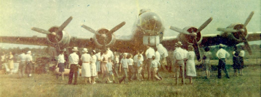
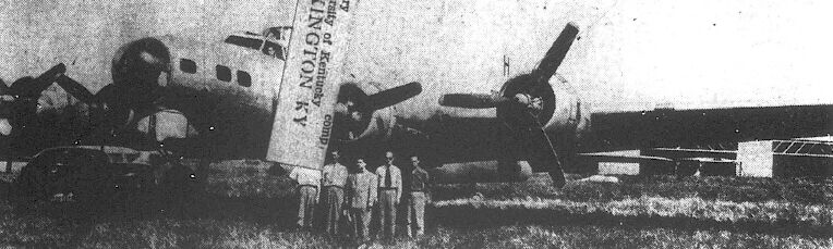
A 1945 photo (courtesy of Christopher Brame) of a surplus Boeing B-17G bomber at Howell Field.
Christopher reported, “My dad was in the Air Scouts just after the war & they had a B-17G.”
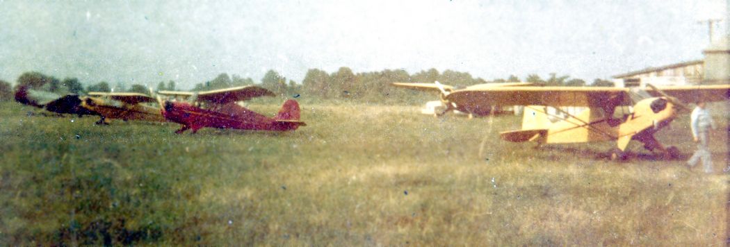
A circa 1945 photo (courtesy of Christopher Brame) of a variety of single-engine taildraggers at Howell Field.
The 1945 AAF Airfield Directory (courtesy of Scott Murdock) described Howell Field
as a 55 acre irregularly-shaped property having an all-way sod landing area measuring 2,100' northwest/southeast.
Howell was said to have a single 60' square metal hangar, and to be owned & operated by private interests.
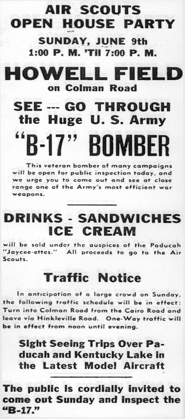
An announcement from the 6/9/46 Paducah Sun-Democrat (courtesy of Christopher Brame) about the display of a Boeing B-17 bomber at Howell Field.
A photo from the 6/9/46 Paducah Sun-Democrat (courtesy of Christopher Brame) of the Boeing B-17G bomber on display at Howell Field.
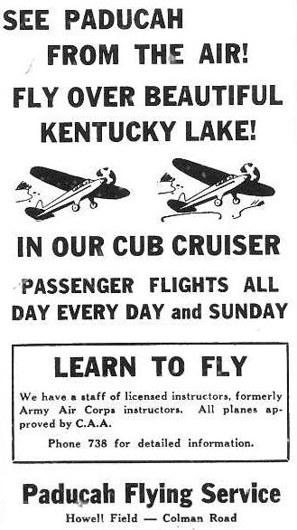
An advertisement for the Paducah Flying Service from the 6/23/46 Paducah Sun-Democrat (courtesy of Christopher Brame).
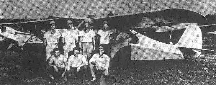
A photo of a group of 7 in front of an Aeronca & a Piper Cub at Howell Airport
from an 8/16/46 Paducah Sun-Democrat (courtesy of Christopher Brame) article entitled “Four receive pilots' licenses under GI Bill”.
According to the program for the 1949 rededication of Barkley Field (courtesy of Christopher Brame),
"The field is still operated & is now leased by Dan Rush for charter service."
According to Christopher Brame, the Air Scout's B-17G at Howell Field “was scrapped around 1950.”
The 1949 USGS topo map depicted Howell Field as commercial/municipal airport.
The last photo of which has been located showing an aircraft at Howell Field was a 5/18/50 aerial view (courtesy of Bill Dunn).
One aircraft was visible next to the hangar, but the B-17 was gone.
The last aeronautical chart depiction of which has been located of Howell Field was on the December 1951 Nashville Sectional Chart.
It depicted Howell as having a mere 1,800' unpaved runway.
Howell Field was evidently closed at some point between 1951-52,
as it was no longer depicted on the June 1952 Nashville Sectional Chart.
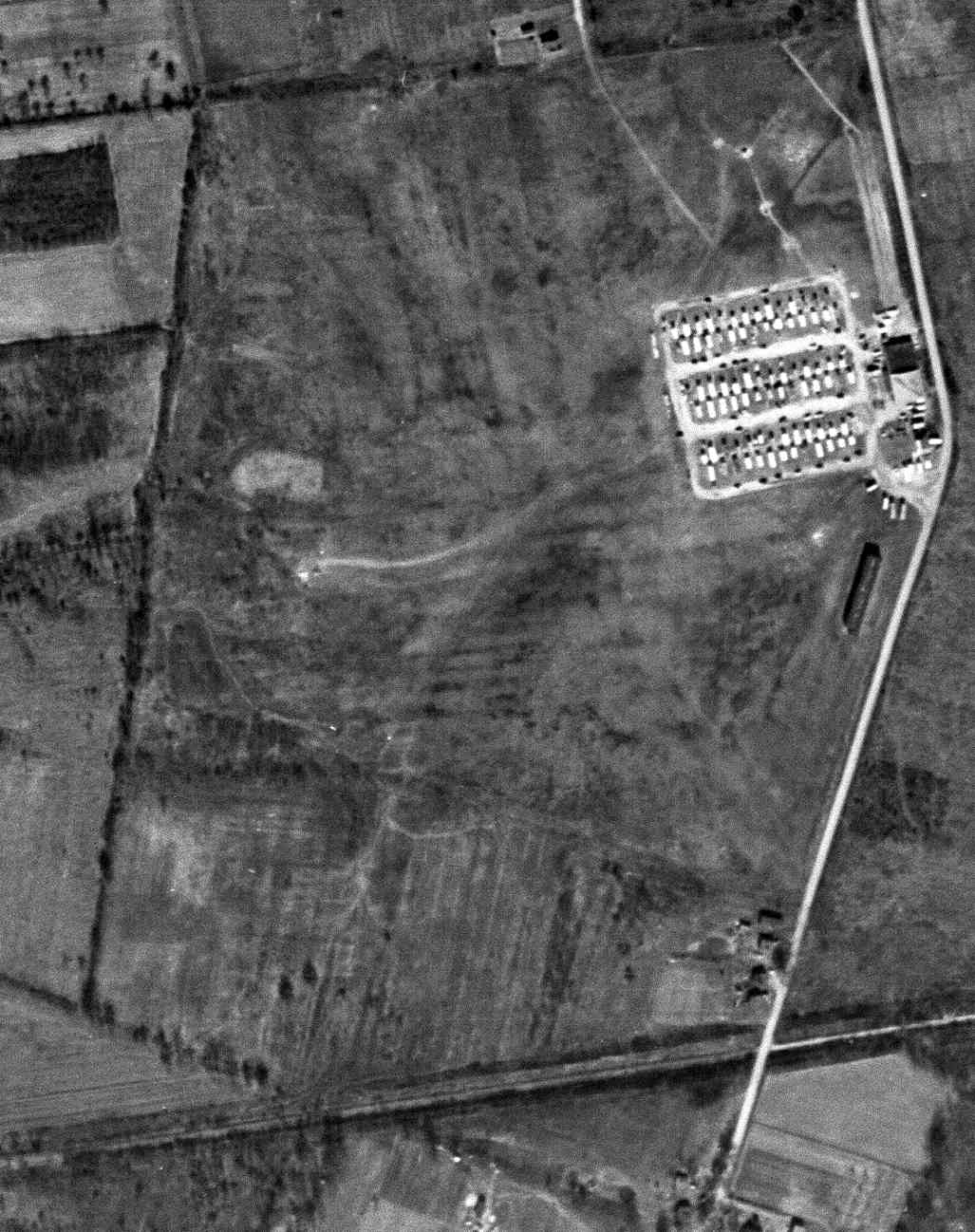
A 2/21/52 USGS aerial photo showed Howell Field after its closure, with rows of several dozen trailers or other objects stored on the field near the hangar, and no sign of any aviation use.
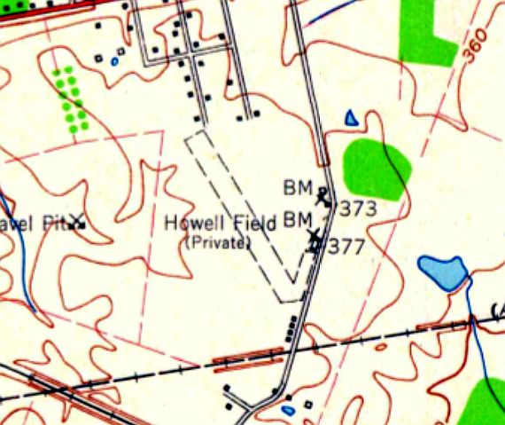
The 1958 USGS topo map depicted Howell Field as having a single unpaved northwest/southeast runway,
with a few small buildings on the east side.
David Drury recalled, “In the late 1960s I had a girlfriend that lived at Howell Field.
The hangar & a long row of T-hangars were still there in 1972. At that time, the hangar did not have any identification & was being used for maintenance of construction equipment.
I also recall the windsock mast & its top hoop.”
A 1993 USGS aerial view showed the hangar had been removed at some point between 1972-93.
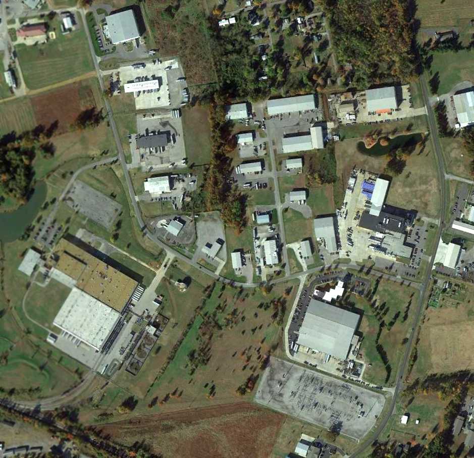
A 2013 aerial view showed no trace remaining of Howell Field.
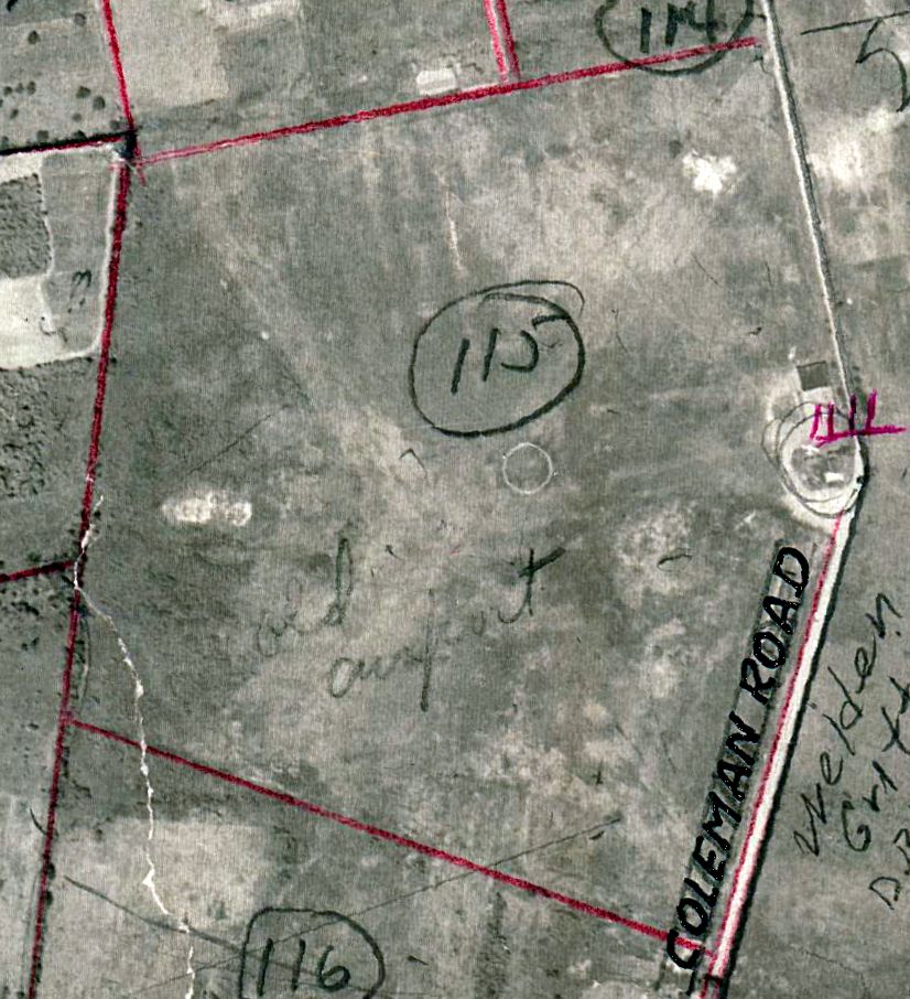
The site of Howell Field is located west of the intersection of Coleman Road & Charter Oaks Drive.
Thanks to Christopher Brame for pointing out this airfield.
____________________________________________________
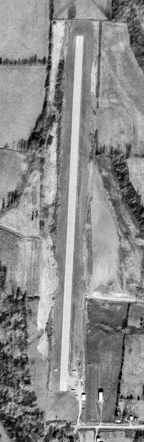
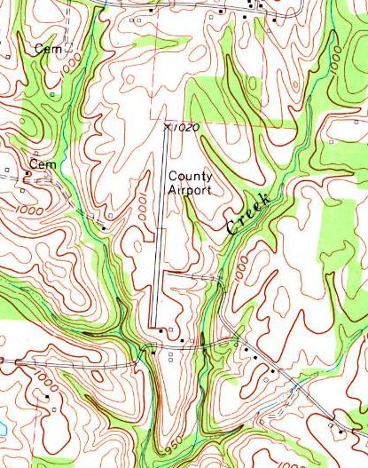
Original Hancock County Airport (X6M5), Petri, KY
37.94, -86.79 (Southwest of Louisville, KY)
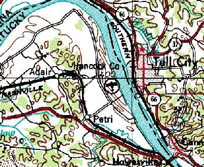
Hancock County Airport, as depicted on the 1974 USGS topo map.
This general aviation airport was evidently established at some point between 1972-74,
as it was not yet depicted on the August 1969 Cincinnati Sectional Chart nor on the 1972 USGS topo map.
The earliest depiction of Hancock County Airport which has been located was on the 1974 USGS topo map.
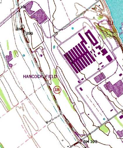
The 1980 USGS topo map depicted “Hancock Field” as having a single paved northwest/southeast runway,
with a taxiway leading to a single small ramp with a single small building on the northwest side.
The earliest photo which has been located of Hancock County Airport was a 1981 aerial view.
It depicted Hancock as having an asphalt Runway 15/33, with a ramp & small hangar on the northwest side & another ramp & small hangar on the southeast side.
There were a total of 3 aircraft visible on the field, including a Learjet on the runway.
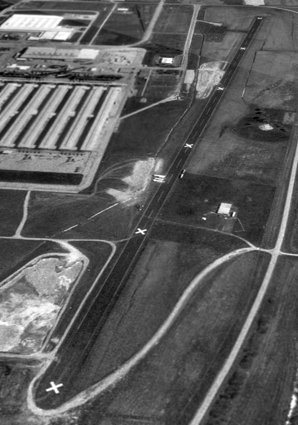
Hancock County Airport was evidently closed at some point between 1981-98,
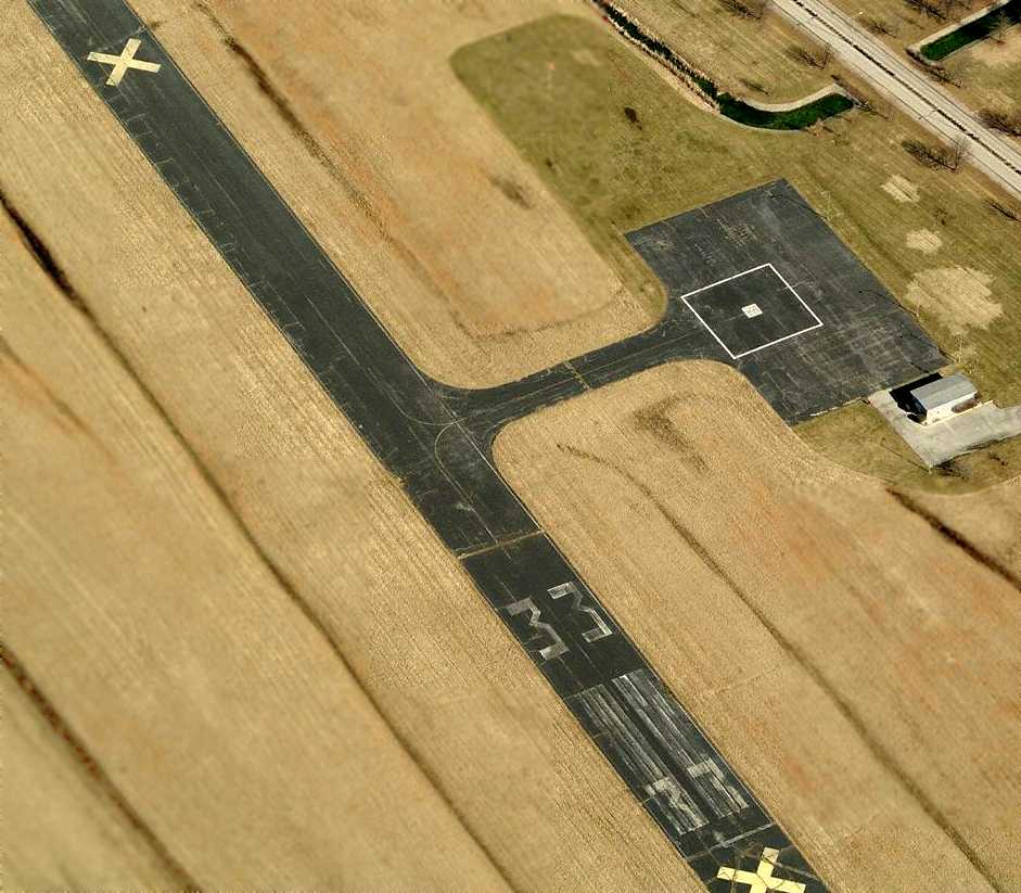
as a 4/11/98 USGS aerial view looking southeast depicted the runway as being painted with 6 closed-runway “X” symbols.
Helipad markings were visible on the southeast ramp.
In 2007 a replacement Hancock County Airport, Ron Lewis Field, was opened a few miles to the northwest.
A January 2009 aerial view by Bob Trader (courtesy of Phil Brooks) looking east at the runway of the former Hancock County Airport,
showing the plant in the background.
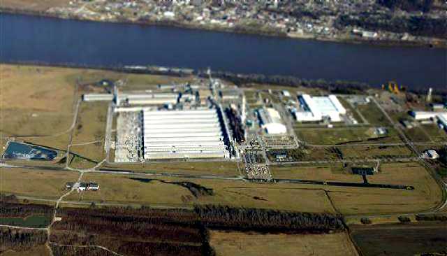
As of 2009, the owner of the “Hancock Airfield Airport” was listed as the National Southwire Aluminum Company,
and a street map labeled the property as “Lamar Field”.
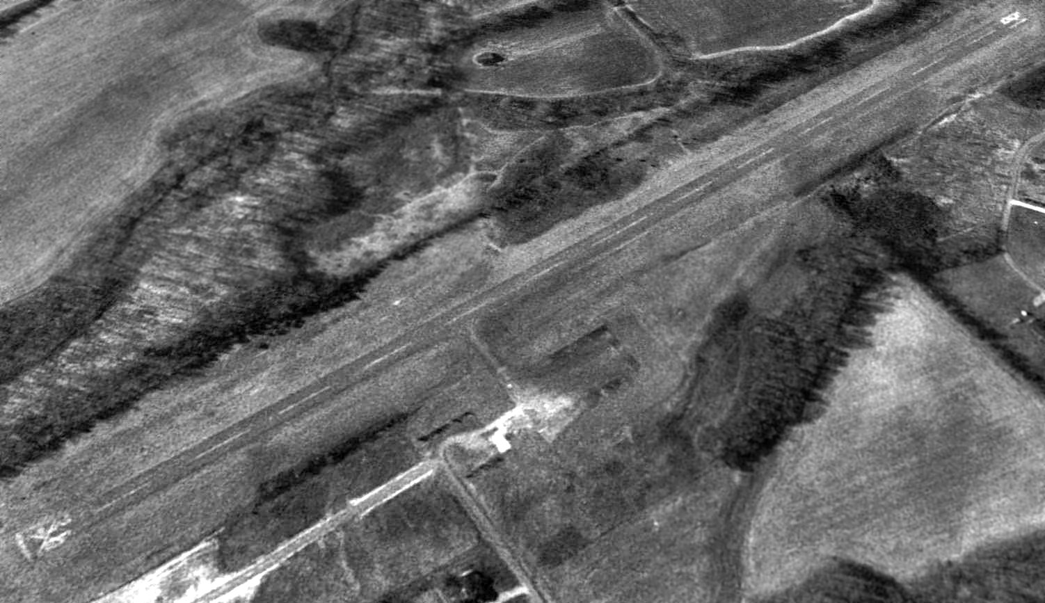
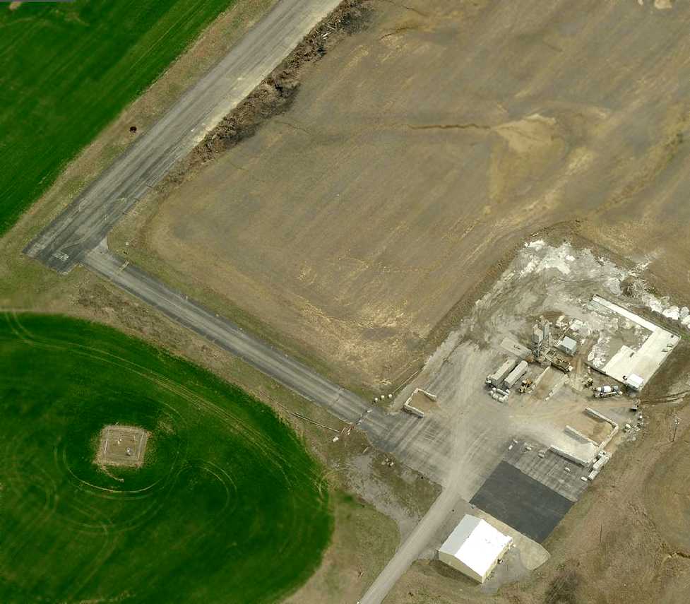
A circa 2010 aerial view looking north at the ramp & runway which remain at the former Hancock County Airport
A 10/7/13 aerial view looking southeast showed the former Hancock County Airport remaining mostly intact.
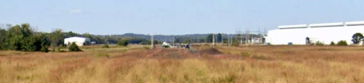
A 2023 photo looking northwest along the the former Hancock County Airport runway, also showing the former hangar on the west side.
The site of Hancock County Airport is located northwest of the intersection of Route 271 & Hawkesville Hancock Airfield Drive.
Thanks to Jamie Winner for pointing out this airfield.
____________________________________________________
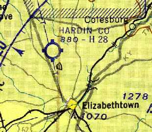
Hardin County Airport / Elizabethtown Airport / Ben Floyd Airport (O19), Elizabethtown, KY
37.75, -85.89 (Southwest of Louisville, KY)
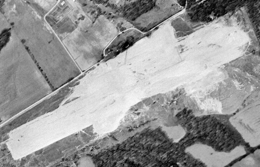
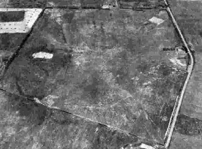
A 4/10/60 USGS aerial photo depicted the Hardin County Airport in the initial stages of construction.
This general aviation airport was built in 1960,
as a 4/10/60 USGS aerial view showed the property having been cleared for construction.
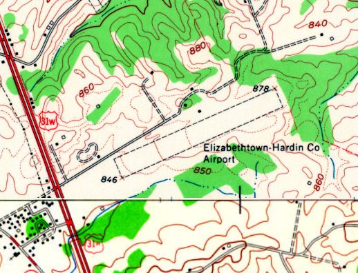
The 1960 USGS topo map depicted the Elizabethtown - Hardin County Airport as having a single unpaved northeast/southwest runway.
Hardin County Airport was not yet depicted on the December 1960 Nashville Sectional Chart.
The earliest aeronautical chart depiction of Hardin County Airport which has been located
was on the December 1961 Nashville Sectional Chart (courtesy of Chris Kennedy).
Hardin County was depicted as having a 2,800' hard-surface runway.
The 1961 USGS topo map depicted the Elizabethtown – Hardin County Airport
as having a single unpaved northeast/southwest runway.
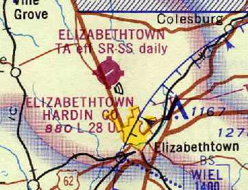
Elizabethtown Hardin County Airport, as depicted on the January 1968 Nashville Sectional Chart (courtesy of Chris Kennedy).
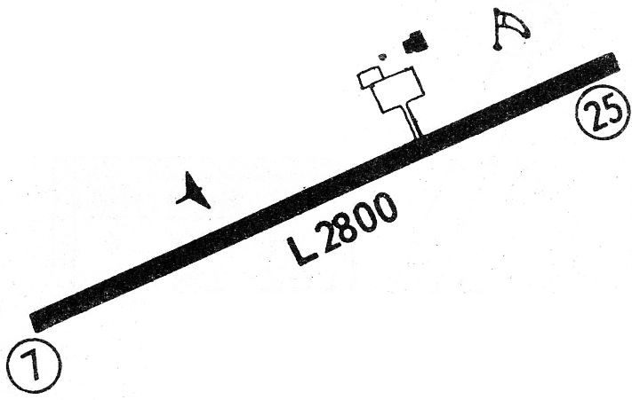
The 1968 Flight Guide (courtesy of Robert Levittan) depicted Hardin County as having a single 2,800' paved Runway 7/25,
with a ramp with 2 small buildings on the north side of the field.
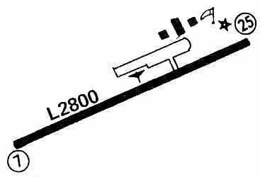
The 1971 Flight Guide (courtesy of Chris Kennedy) depicted Hardin County as having a single 2,800' paved Runway 7/25,
with a ramp with 3 buildings (hangars?) on the north side of the field.
The 1975 USGS topo map depicted the Elizabethtown – Hardin County Airport as having a single paved northeast/southwest runway.
The field was apparently renamed Ben Floyd Field at some point between 1971-76,
as that is how it was listed in the 1976 AOPA Airport Directory (courtesy of Chris Kennedy).
It described the field as offering repairs, fuel, charter, and tiedowns. The operator was listed as Elizabethtown Flying Service.
Floyd Field was still listed as an active airport in the 1979 Flight Guide (courtesy of Chris Kennedy).
The 1983 USGS topo map labeled it as Ben Floyd Airfield.
By the time of the 1986 Flight Guide (according to Chris Kennedy), Ben Floyd Field was no longer listed.
It had apparently been replaced by the new Addington Airport (just west of the town of Elizabethtown),
which was built with a longer runway.
The 1987 USGS topo map labeled it as “Ben Floyd Airfield (Abandoned)”.
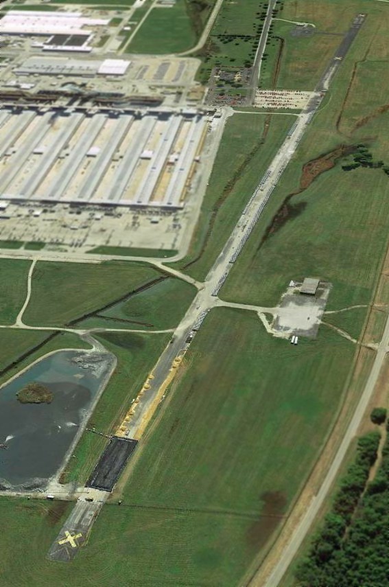
A 1997 USGS aerial photo showed that the eastern half of the airport site had been covered by a new housing development,
with several new streets (Sunningdale Way & Turnberry Way) having been built over the runway.
However, the outline of a 1,000' portion of the western end of the runway remained intact.
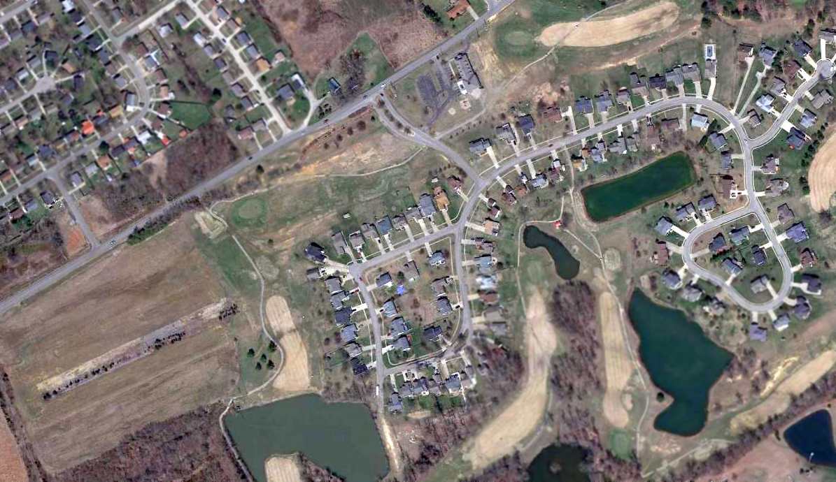
A 4/4/13 aerial photo showed that a 1,000' portion of the western end of the Elizabethtown runway still remains intact.
The site of Elizabethtown Airport is located east of the intersection of Route 31 & Pine Valley Drive.
____________________________________________________
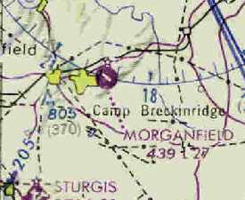
Camp Breckenridge Army Airfield / Morganfield Airport, Morganfield, KY
37.69, -87.84 (Northwest of Nashville, TN)
Camp Breckenridge AAF, as depicted on the December 1951 Nashville Sectional Chart.
This military airfield was located on the grounds of Camp Breckenridge.
According to "WW2 Sites in the US" by Richard Osborne,
Camp Breckenridge was built in 1942 as a training camp for infantry units up to division size.
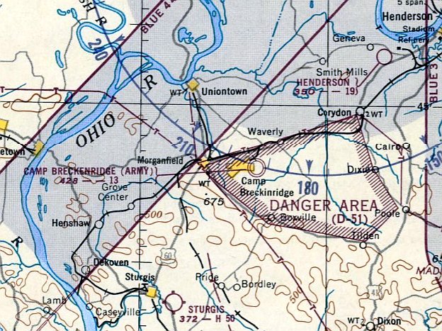
No airfield at the Camp was depicted on the March 1944 Nashville Sectional Chart (according to Chris Kennedy),
although there was a large Danger Area depicted over the Camp (most likely due to live artillery fire).
According to Mark Rickert, “The camp's original airfield was the Sturgis Airport, [which] was disposed of after WWII.
In the late 1940s part of the 101st [Airborne Division] moved in & the lack of airfield became problematic for air airborne operations.”
The Camp Breckenridge Airfield was not yet depicted on the June 1951 Nashville Sectional Chart nor the 1951 USGS topo map.
The earliest depiction which has been located of Camp Breckenridge Army Airfield was on the December 1951 Nashville Sectional Chart.
It depicted “Camp Breckenridge (Army)” Airfield as having a mere 1,300' unpaved runway.
The Aerodromes table on the June 1953 Nashville Sectional Chart (courtesy of Chris Kennedy)
described Breckenridge Army Airfield as having 2 runways, with the longest being a 1,500' unpaved strip.
According to "WW2 Sites in the US" by Richard Osborne,
Camp Breckenridge was used during 1954-63 as a training camp for the Kentucky National Guard.
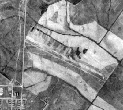
A 4/11/56 USGS aerial photo depicted Breckenridge AAF as having an unpaved northwest/southeast runway.
There did not appear to be any hangars or other improvements.
Breckenridge AAF apparently gained a paved runway at some point between 1956-62,
as the June 1962 Nashville Sectional Chart (courtesy of Chris Kennedy) described the field as having a single 2,700' bituminous runway.
It also said "Tower operates days July 1 through August 10."
According to "WW2 Sites in the US" by Richard Osborne, National Guard use of Camp Breckenridge ended in 1963 & it was parceled out to various organizations,
including some portions which were reused as a Job Corps Camp.
The airfield apparently closed at the same point in 1963.
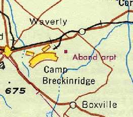
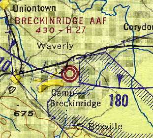
Breckenridge AAF was labeled "Aband arpt" on the January 1968 Nashville Sectional Chart (courtesy of Chris Kennedy).
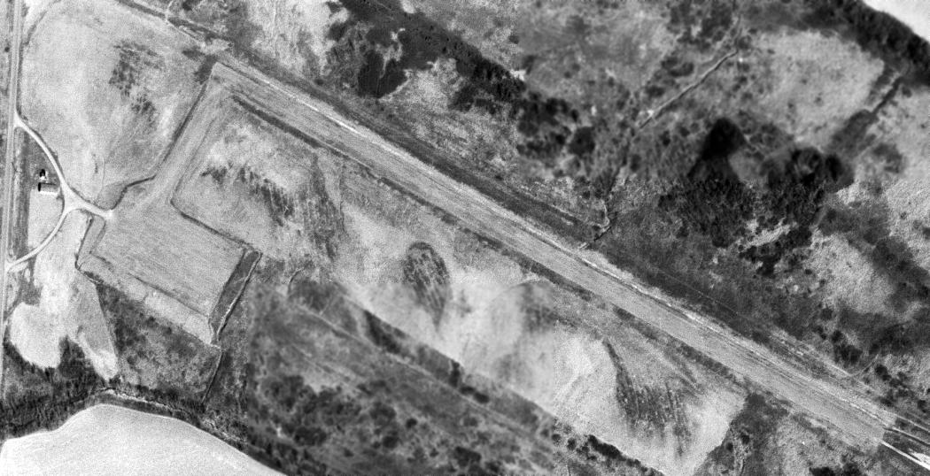
A 3/4/68 USGS aerial photo depicted Breckenridge AAF as having a paved northwest/southeast runway, with a paved ramp on the southwest side.
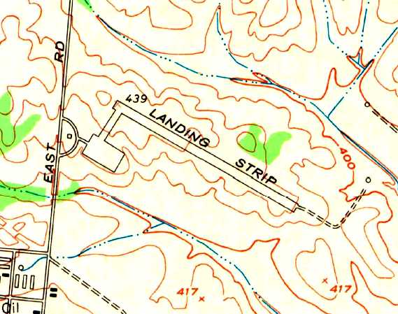
The 1969 USGS topo map depicted Breckenridge AAF as a single paved northwest/southeast runway, labeled “Landing Strip”,
with a taxiway leading to a ramp & one small building on the west side.
No airfield at the location was listed in the 1971 Flight Guide (according to Chris Kennedy).
But the former Army Airfield was apparently reopened as a civil airport at some point between 1971-74,
as it was labeled "Morganfield" Airport on the 1974 USGS topo map.
Morganfield Airport, as depicted on the August 1976 CG-20 World Aeronautical Chart (courtesy of Chris Kennedy).
The 1976 AOPA Airport Directory (courtesy of Chris Kennedy) described Morganfield Airport
as having a single 2,700' asphalt Runway 12/30,
but described the field as unattended.
A Bituminous Surface Rehabilitation Project was carried out at Morganfield Airport in 1982,
with the Construction Inspection performed by Johnson, Depp & Quisenberry.
Morganfield Airport was still described in the same fashion in the "Low-Use" airports section
of the 1986 Flight Guide (according to Chris Kennedy).
The Morganfield Airport was owned by the City of Morganfield.
Morganfield was still depicted as an active airfield on the 1998 World Aeronautical Chart.
The Morganfield Airport apparently was closed (for reasons unknown) at some point within 1998,
as a 1998 USGS aerial view clearly showed closed-runway "X" symbols along the runway.
A taxiway led to a small ramp along the west side of the field, which contained a few small buildings (and appeared to be used for storage of trucks or trailers).
A circa 2010 aerial view looking south at Morganfield Airport showed the Runway 12 markings to still remain recognizable.
Construction of some sort was situated on the former ramp.
A 2020 aerial view showed the Morganfield Airport runway to remain intact.
Morganfield Airport is located southeast of the intersection of Route 60 & Route 2091.
____________________________________________________
Since this site was first put on the web in 1999, its popularity has grown tremendously.
If the total quantity of material on this site is to continue to grow,
it will require ever-increasing funding to pay its expenses.
Therefore, I request financial contributions from site visitors,
to help defray the increasing costs of the site
and ensure that it continues to be available & to grow.
What would you pay for a good aviation magazine, or a good aviation book?
Please consider a donation of an equivalent amount, at the least.
This site is not supported by commercial advertising –
it is purely supported by donations.
If you enjoy the site, and would like to make a financial contribution,
you
may use a credit card via
![]() :
:
Please consider checking the box to make a monthly donatation.
For a mailing address to send a check, please contact me at: paulandterryfreeman@gmail.com
If you enjoy this web site, please support it with a financial contribution.
please contact me at: paulandterryfreeman@gmail.com
If you enjoy this web site, please support it with a financial contribution.
____________________________________________________
This site covers airfields in all 50 states.