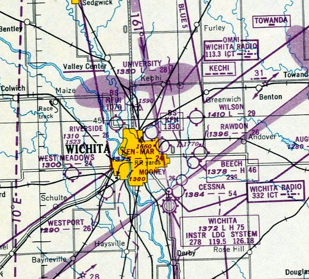
Abandoned & Little-Known Airfields:
Kansas: Wichita area
© 2002, © 2024 by Paul Freeman. Revised 4/3/24.
This site covers airfields in all 50 states: Click here for the site's main menu.
____________________________________________________
Please consider a financial contribution to support the continued growth & operation of this site.
Buckley Aircraft Airfield / Rawdon Field / Copeland Field / Beech North Airport (revised 1/7/23) - Clothier Landing Field (revised 6/13/23) - Hamilton Airport (revised 1/7/23)
Mooney Airfield (revised 1/7/23) - Riverside Airport (revised 4/3/24) - (Original) Salina Airport (revised 10/18/21)
Swallow Field / United Aircraft Airfield / University Airport (revised 1/7/23) - Wilson Field / Ken-Mar Airport (revised 2/10/20)
____________________________________________________
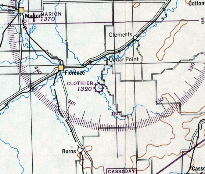
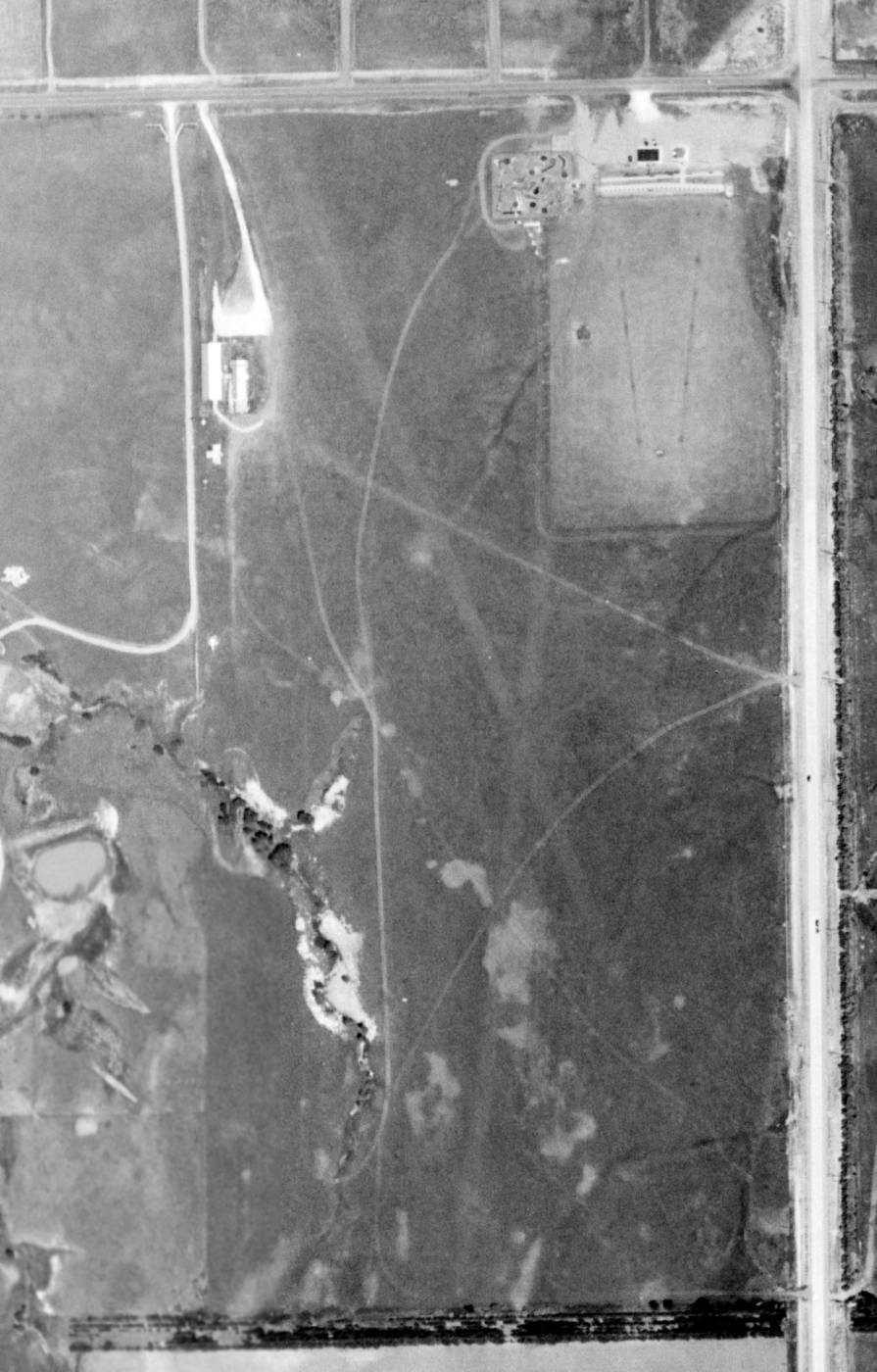
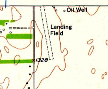
Clothier Landing Field, Cedar Point, KS
38.203, -96.838 (Northeast of Wichita, KS)
Clothier Landing Field”, as depicted on the March 1946 Salina Sectional Chart.
Photo of the airfield while in use has not been located.
This small general aviation airport was evidently established at some point between 1945-46
(like hundreds of other small airports in the US post-WW2 aviation boom),
as it was not yet depicted on the 1945 Salina Sectional Chart.
The earliest depiction which has been located of Clothier Landing Field was on the March 1946 Salina Sectional Chart.
It depicted Clothier as a commercial/municipal airport.
The earliest photo which has been located of Clothier Landing Field was a 1956 aerial view.
It depicted 2 unpaved runways, with a T-hangar & another small building on the southwest side.
There were no aircraft visible on the field.
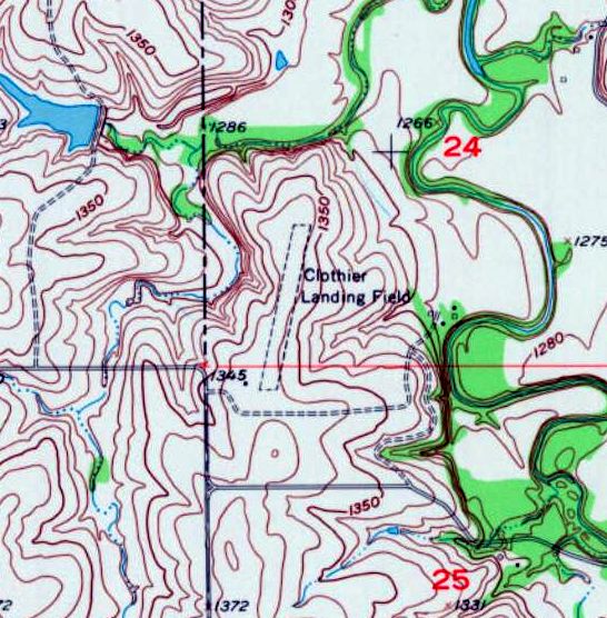
The earliest topo map depiction which has been located of Clothier Landing Field was on the 1957 USGS topo map.
It depicted Clothier Landing Field as having a single unpaved northeast/southwest runway, with 1 small building on the southwest side.
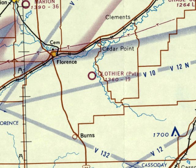
The last aeronautical chart depiction which has been located of Clothier Landing Field was on the April 1946 Salina Sectional Chart.
It depicted Clothier as a private airfield having a mere 1,900' unpaved runway.
Clothier Landing Field was evidently closed (for reasons unknown) at some point in 1965,
as it was no longer depicted on the September 1965 Salina Sectional Chart.
A 2007 photo looking northeast showed no recognizable trace of Clothier Landing Field.
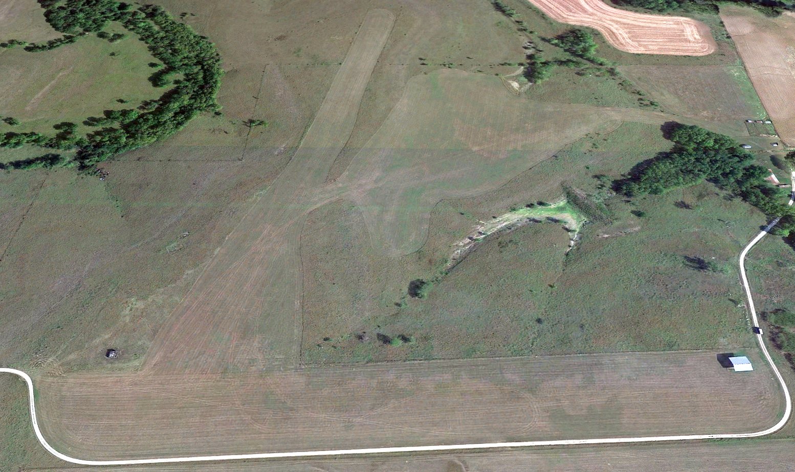
A 2022 aerial view looking north depicted Clothier Landing Field as having 2 unpaved runways, with 1 former airfield building on the southwest side.
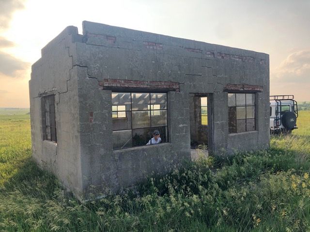
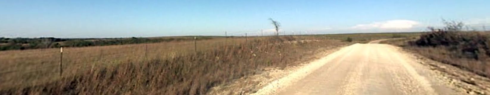
A 2023 photo of a building which remains at the site of Clothier Landing Field.
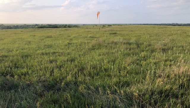
A 2023 photo of a windsock which remains at the site of Clothier Landing Field.
____________________________________________________
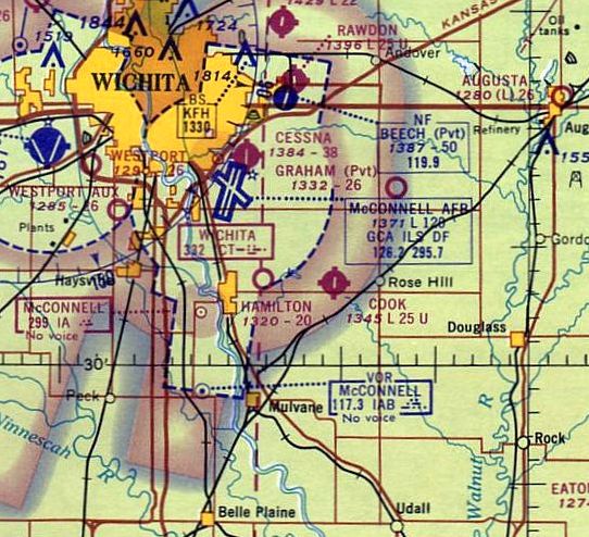
Hamilton Airport (1K3), Derby, KS
37.561, -97.234 (Southeast of Wichita, KS)
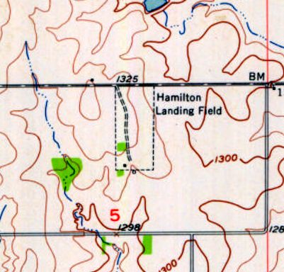
“Hamilton Landing Field”, as depicted in the 1955 USGS topo map.
Photo of the airfield while in use has not been located.
The date of construction of this small general aviation airport has not been determined.
Hamitlon Airport may have originated as far back as the 1930s,
as a 1938 aerial photo appeared to show a single north/south grass runway with a row of small buildings along the west side.
Hamilton Airport was not depicted on the 1943/44/49 Wichita Sectional Charts.
The 1955 USGS topo map depicted “Hamilton Landing Field” as a north/south oriented rectangular property outline,
with a road along the west side, and a single small building on the southwest corner.
Hamilton Airport was not depicted on the May 1957 Wichita Sectional Chart.
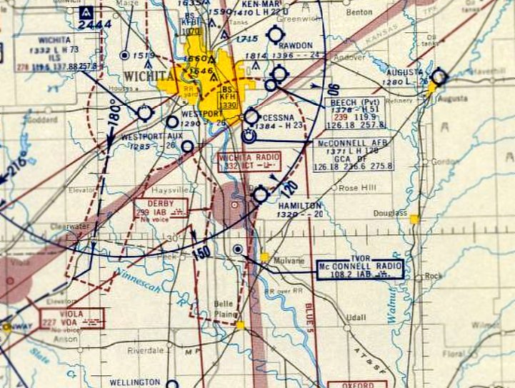
The earliest aeronautical chart depiction which has been located of Hamilton Airport was on the December 1957 Wichita Sectional Chart.
It depicted Hamilton as a public-use airport having a 2,000' unpaved runway.
A 1960 aerial photo depicted Hamilton Airport as having a north/south grass runway,
with a large number of individual T-hangars along the west side.
The 1965 Wichita Sectional Chart depicted Hamilton as a public-use airport having a 2,000' unpaved runway.
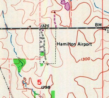
The 1970 USGS topo map depicted “Hamilton Airport” as a north/south oriented rectangular property outline,
with a road along the west side, and 8 small buildings along the west side.
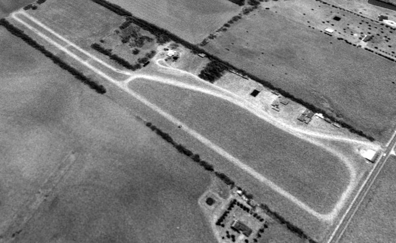
A 1996 aerial view looking southwest depicted Hamilton Airport as having an unpaved north/south runway & a number of T-hangars along the west side.
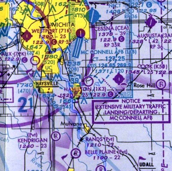
The 1999 Wichita Sectional Chart depicted Hamilton Airport as a public-use airport having a 2,600' unpaved runway.
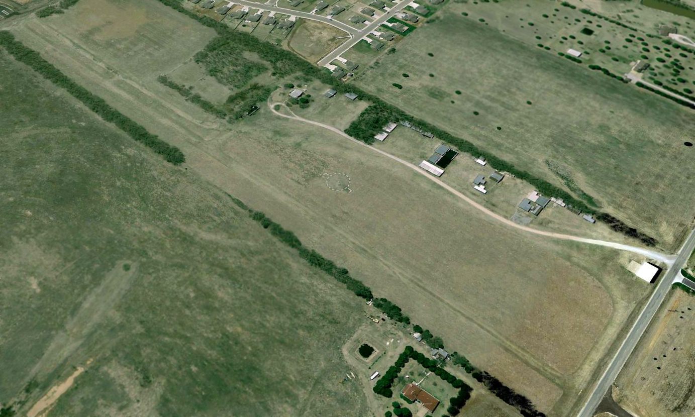
The last photo which has been located showing Hamilton Airport still largely intact was a 2006 aerial view looking southwest.
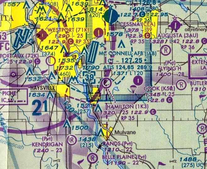
The last aeronautical chart depiction which has been located of Hamilton Airport was on the January 2008 Wichita Sectional Chart.
It depicted Hamilton as a public-use airport having a 3,500' unpaved runway.
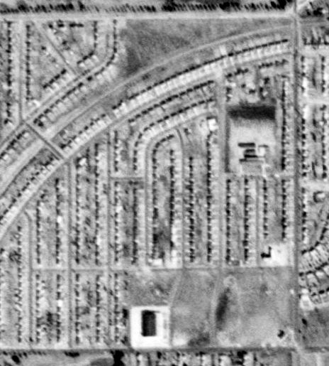
Hamilton Airport was evidently closed by 2008, as a 2008 aerial view showed the hangars had been removed.
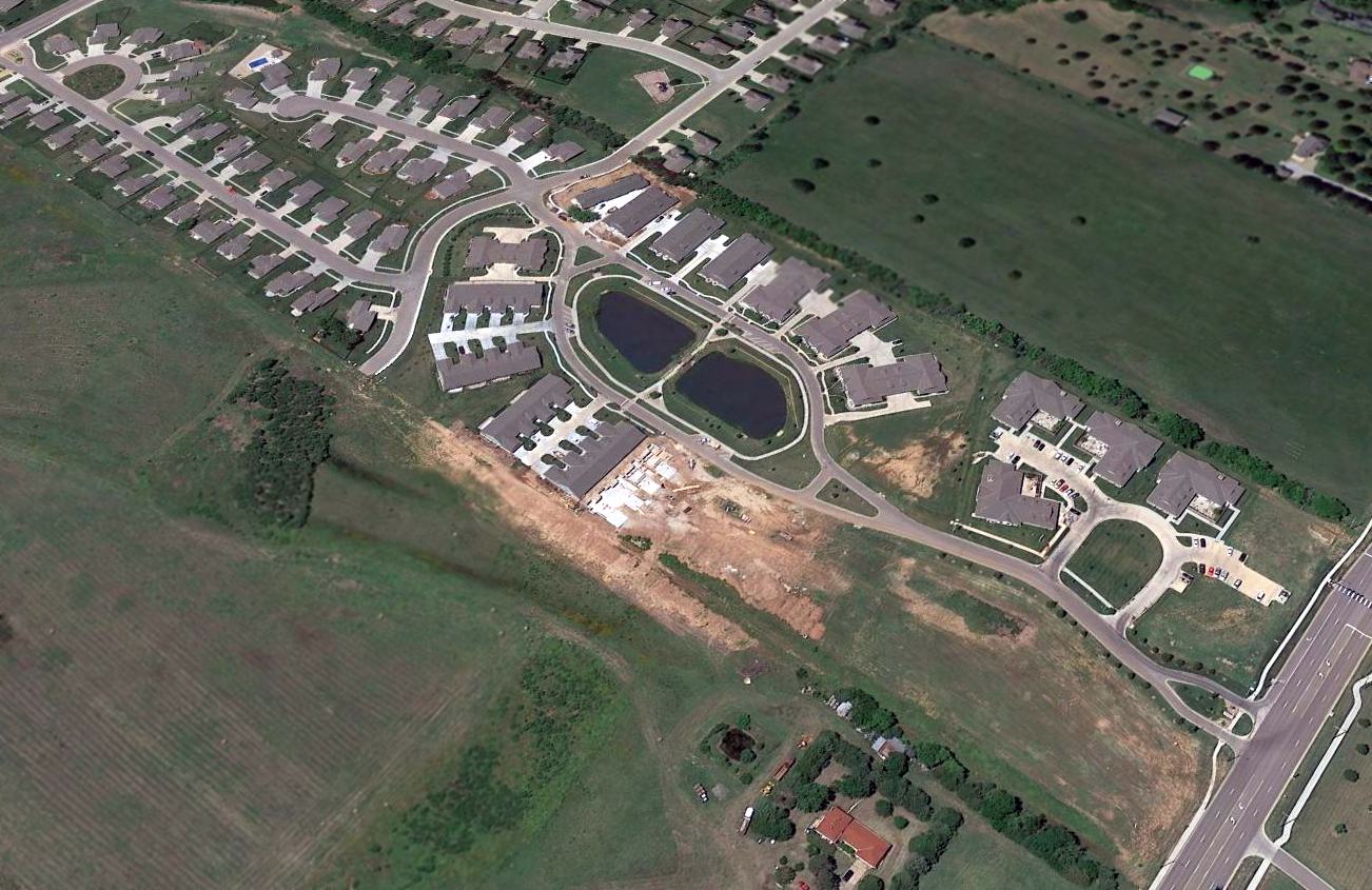
A 2015 aerial view looking southwest showed that Hamilton Airport befell the same fate as that of hundreds of other small grassroots airports: the property was redeveloped as a housing development.
Hamilton Airport was no longer depicted on the July 2016 Wichita Sectional Chart.
The site of Hamilton Airport is located south of the intersection of Meadowlark Boulevard & Hamilton Drive.
____________________________________________________
Wilson Field / Country Club Airport / Ken-Mar Airport (original location), Wichita, KS
37.71, -97.283 (Northeast of Downtown Wichita, KS)
Wilson Field, as depicted in the 1945 AAF Airfield Directory (courtesy of Scott Murdock).
Photo of the airfield while in use is not available.
This airfield was evidently established at some point between 1944-45,
as a 1938 aerial photo showed a north/south oriented clear field, without any hangars or other recognizable signs of an airfield,
and no airfield was depicted at this location on the August 1944 Wichita Sectional Chart.
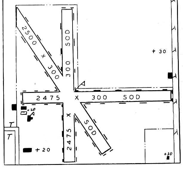
The earliest depiction which has been located of Wilson Field was a diagram in the 1945 AAF Airfield Directory (courtesy of Scott Murdock).
The directory described Wilson Field as a 160 acre square-shaped property having 4 sod runways, with the longest being the 2,640' northeast/southwest strip.
The field was said to not have any hangars, and to be owned & operated by private interests.
Mike Nelson recalled, “The runway ran north to south right next to Oliver Avenue & extended from 13th Street to the tracks at 17th Street.
On 21st Street to the North there sat a beautiful brick house with vaulted chimneys & steep slate roof. It belonged to a surgeon of some repute.
In 1945 Cessna landed their 1st prototype Model 140 at Ken Mar & taxied up a quiet Oliver Street to this house & took publicity pictures of it that were widely distributed.
My dad Earl Nelson flew a Piper Cub from Wilson Field / Ken-Mar Airport after he returned back home from WW2.”
This airfield was evidently renamed Country Club Airport at some point in 1945,
as that is how it was labeled on the September 1945 Wichita Sectional Chart.
An article in the 9/7/45 Wichita Beacon (courtesy of Michael Gerik) announced, “E.E. Isaacs & E.W. Yockey announce the change of name from Country Club Airport to Ken-Mar Airpark.
Isaacs & Yockey have recently taken over ownership of this field. Instructors at Ken-Mar Airpark are Bill Underwood & Marvin Sneed.”
Ken-Mar Airport was depicted on the March 1946 Wichita Sectional Chart.
Mike Nelson recalled, “In 1947 there was an airshow featuring a P-51 Mustang & a glider doing aerobatics.”
The last depiction which has been located of Ken-Mar Airport was on the October 1949 Wichita Sectional Chart.
It depicted Ken-Mar as having a 2,400' unpaved runway.
Mike Nelson recalled, “One frosty morning in 1949 a guy took off in a Cessna 170 to the South with frost on his wings & plowed into the bungalow houses that had been built up right to 13th Street.
The city of Wichita told Ken Mar to move from Wilson Field to a farm field at 3500 North Webb Road, [which] became Jabara Airport in 1980.”
According to Mike, Wilson Field ceased operation in 1950.
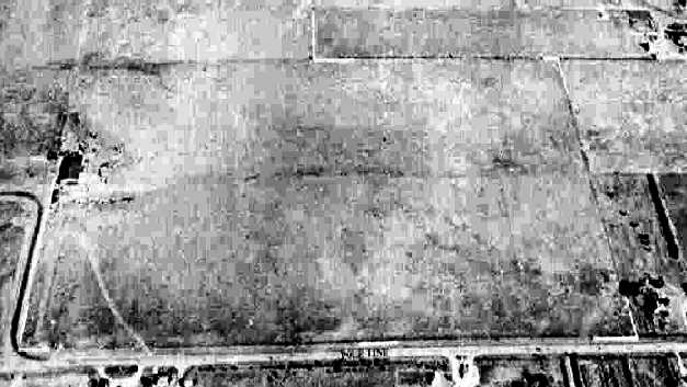
The earliest photo which has been located of Wilson Field was a 1950 aerial view, presumably taken after its closure.
Two unpaved runways in an X-shape were still recognizable, but deteriorated.
A single curved-roof hangar sat at the southwest corner of the property, northeast of the intersection of 13th Street & Crestway Street.
A row of houses had already been built along the western edge of the airport,
but there were not any other larger buildings (any other hangars) on the field.
Ken-Mar Airport was no longer depicted on the May 1950 Wichita Sectional Chart.
An 11/2/54 USGS aerial view of the Wilson Field site showed it had become almost complete covered with houses at some point between 1950-54.
The hangar at the southwest corner remained intact, as the only remnant of the little airport.
Another curved-roof building had been added at some point between 1950-54 at the northeast corner of the airport site,
but in spite of its appearance this was evidently not a former hangar, as it was built after Wilson Field's closure.
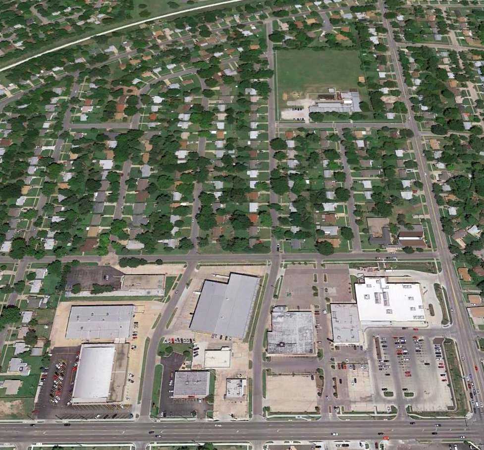
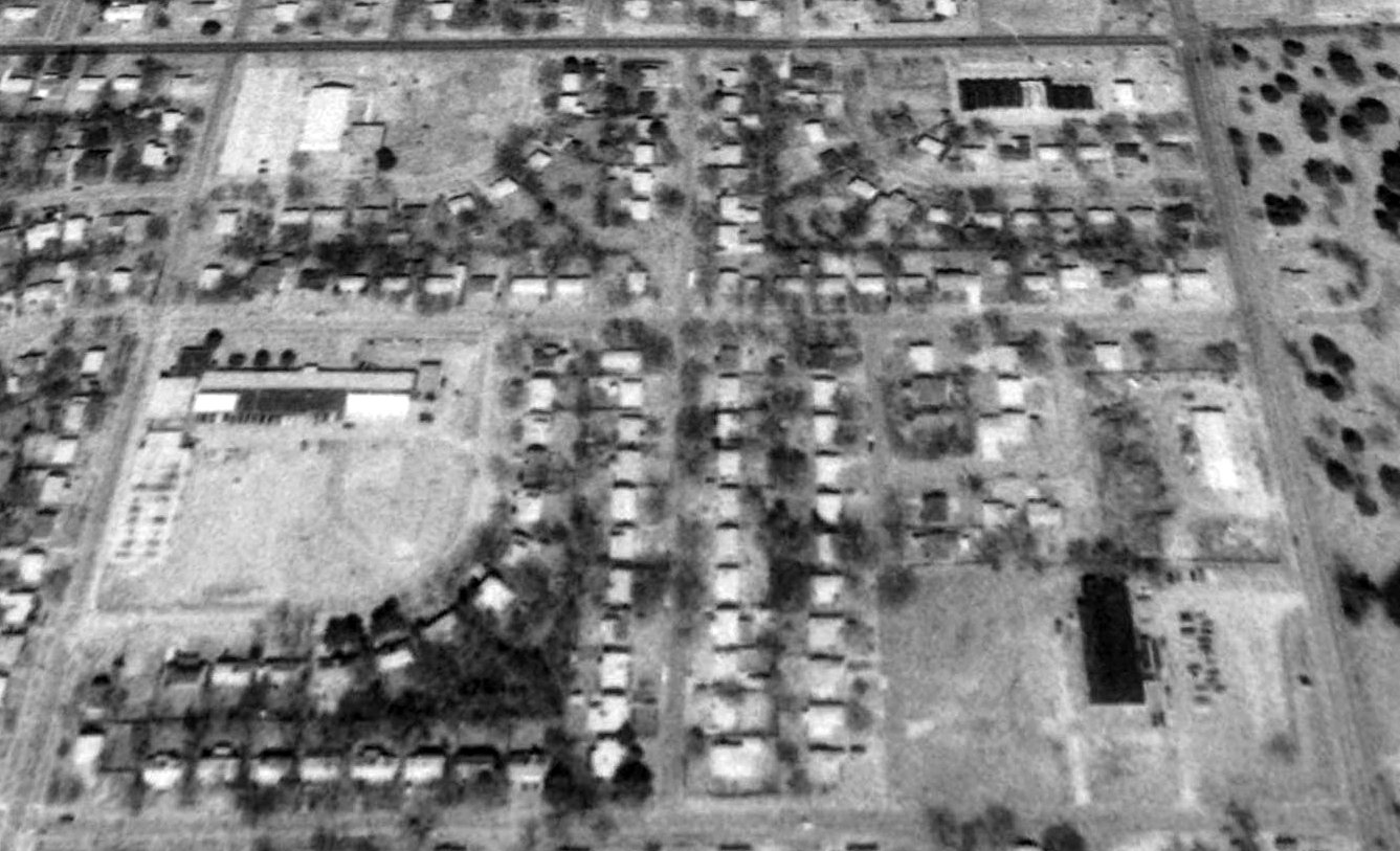
A 2015 aerial view looking north at the site of Wilson Field showed the property covered by houses & other buildings,
but the former hangar at the southwest corner remained intact.
Mike Nelson reported in 2015, “A large round-topped hangar at 13th Street & Crestway Street became a bowling alley & is now a furniture store.”
The site of Wilson Field is located northwest of the intersection of East 13th North Street & North Oliver Avenue.
Thanks to Mike Nelson for pointing out this airfield.
____________________________________________________
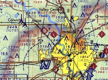
37.66, -97.25 (Northeast of McConnell AFB, KS)
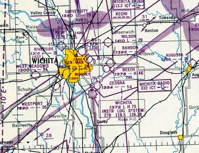
Mooney Airfield, as depicted on the October 1949 Wichita Sectional Chart.
Photo of the airfield while in use is not available.
The original factory airfield for the Mooney Aircraft company was located on the east side of Wichita,
adjacent to the north side of Cessna's airfield.
The Mooney Airfield was evidently established at some point between 1944-47, as it was not yet depicted on a 1938 aerial view
or the February 1943 Wichita Sectional Chart (courtesy of Ron Plante) or the February 1944 Wichita Sectional Chart (courtesy of Tim Zukas).
Bill Schmidt recalled, “The original Mooney Factory Field at Harry & Rock Road...
This is where Al Mooney made the 1st Mooney Mite [1947] with the Crosley Cobra V-belt 25 hp engine in it, and got it certificated!
I remember hearing it in the air as it made a neat whistling sound through the bottom nose-mounted radiator when it flew over.
The Mite was built (800 each) in Wichita at Harry & Rock Road from 1947-55.”
The Mooney Airfield was still not yet depicted on the March 1949 Wichita Sectional Chart.
The earliest depiction which has been located of the Mooney Airfield was on the October 1949 Wichita Sectional Chart.
It depicted Mooney Airfield as having a 2,600' unpaved runway, and to be directly adjacent to the northeast side of the Cessna Airfield.
The only photo which has been located showing Mooney Airfield while in use was a 1950 USGS aerial view.
It depicted a north/south oriented unpaved airfield, with 2 hangars, a T-hangar, and 6 light single-engine aircraft on the west side.
The last aeronautical chart depiction which has been located showing Mooney Airfield still in operation was on the October 1952 Wichita Sectional Chart.
Strangely, it still depicted the symbol for Mooney Airfield, but without any label (similarly with the adjacent Cessna Airfield).
Bill Schmidt recalled, “The original Mooney Factory Field... I went to a model airplane contest there in 1953 & a Culver V sat on the field.
The large commercial buildup on the southwest quadrant of Harry Street & Rock Road was non-existent in the 1950s.
It was an open field from the tin shed Mooney factory to the East to Rock Road & also to the South to Harry Street.
The runway ran North/South (naturally in KS) & was just the sod / grass closer to the factory than to Rock Road.
One could not have a model airplane contest in a small field at that time as models were free flight & not radio-controlled.
This took a lot of space as the models drifted downwind freely.
There was one pioneer radio-control man, Charles Siegfried, there to demonstrate it's function - it didn't.
There was a whole lot of shouting & waving of handkerchiefs as well as hand signals & derision to & from the man's helper.
Nothing worked, and no flight was made. This Keystone Kops scene was very memorable to this 12 year old kid.”
Mooney Airfield was evidently closed at some point between 1952-53,
as it was no longer depicted on the May 1953 Wichita Sectional Chart.
The earliest photo which is available of Mooney Airfield was a 6/19/54 USGS aerial view.
Mooney Airfield may have already been closed by this point (as the company established its factory in Kerrville TX),
as the photo showed the airfield to be devoid of aircraft, though the grass landing area remained clear,
and the 3 hangars remained standing on the west side of the property.
Bill Schmidt recalled, “The 1955 Mooney Mite featured a new-style bubble center section canopy & was the last of the Mite series.
Al Mooney constantly fought the city of Wichita over their high appraisals of the land where he was located.
The factory was a lone modest steel building on far northwest side of a ¼ section.
Al got fed up with this treatment & moved the factory to Kerrville TX in 1955.”
A 1996 aerial view showed the Mooney Airfield property had been covered with commercial buildings.
Although some buildings on the west side were close to the location of the original hangars,
a close comparison of aerial photos reveals that none of the later buildings correspond to the precise location of the original hangars.
A 2014 aerial view shows no trace remaining of Mooney Airfield.
The site of Mooney Airfield is located southwest of the intersection of East Harry Street & South Rock Road.
Thanks to Bill Schmidt for pointing out this airfield.
____________________________________________________
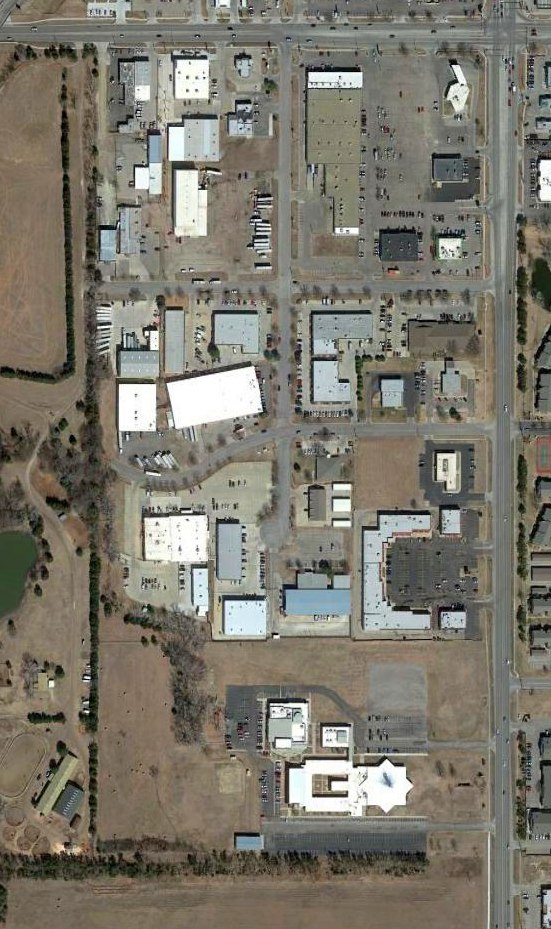
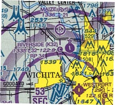
Riverside Airport (K32), Wichita, KS
37.75, -97.406 (Northwest of Downtown Wichita, KS)
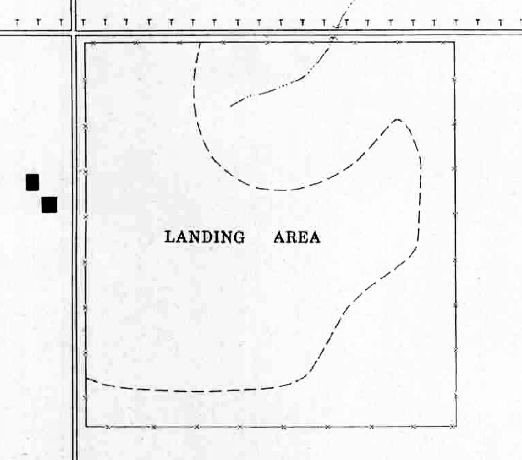
The 1956 USGS topo map depicted a single unpaved northwest/southeast runway, labeled simply as “Landing Field”.
Riverside Airport was not yet depicted on a 1950 aerial photo.
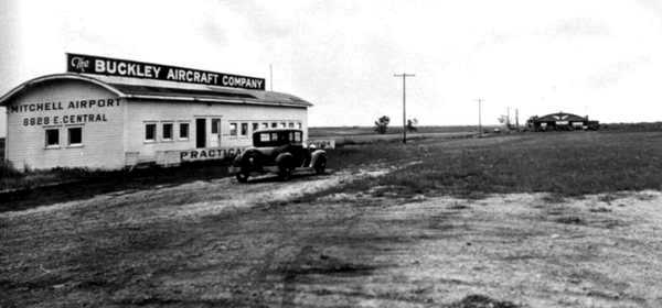
According to an article entitled “Cornejo & Sons in process of buying Riverside Airport” by Molly McMillin in the 2/24/14 Wichita Eagle (courtesy of Dana Shifflett),
this small general aviation airport was founded in 1953 by the family of Tom Sanders.
The earliest depiction which has been located of Riverside Airport was on the 1956 USGS topo map,
which depicted a single unpaved northwest/southeast runway, labeled simply as “Landing Field”.
The earliest photo which has been located of Riverside Airport was 1956 aerial view,
which depicted a single unpaved northwest/southeast runway, with 1 single-engine plane, 1 twin-engine plane, and 3 T-hangars on the northwest side.
The earliest photo which is available of Riverside Airport was on a 9/25/60 USGS aerial view,
which depicted a single unpaved northwest/southeast runway, with one single-engine plane & several T-hangars on the northwest side.
Riverside Airport's FAA Airport/Facility Directory data had an activation date of March 1964,
which is presumably when it was registered with the FAA.
Riverside Airport was not yet listed among active airports in the 1968 Flight Guide (courtesy of Robert Levittan)
nor depicted on the January 1969 Wichita Sectional Chart.
The earliest aeronautical chart depiction which has been located of Riverside Airport was on the 1971 Wichita Sectional Chart (courtesy of Ed Granato).
It depicted Riverside as having a single paved 3,000' runway.
Brett Harris recalled of Riverside Airport, “I used to hangar my old 172 there... I loved Tom Sanders.”
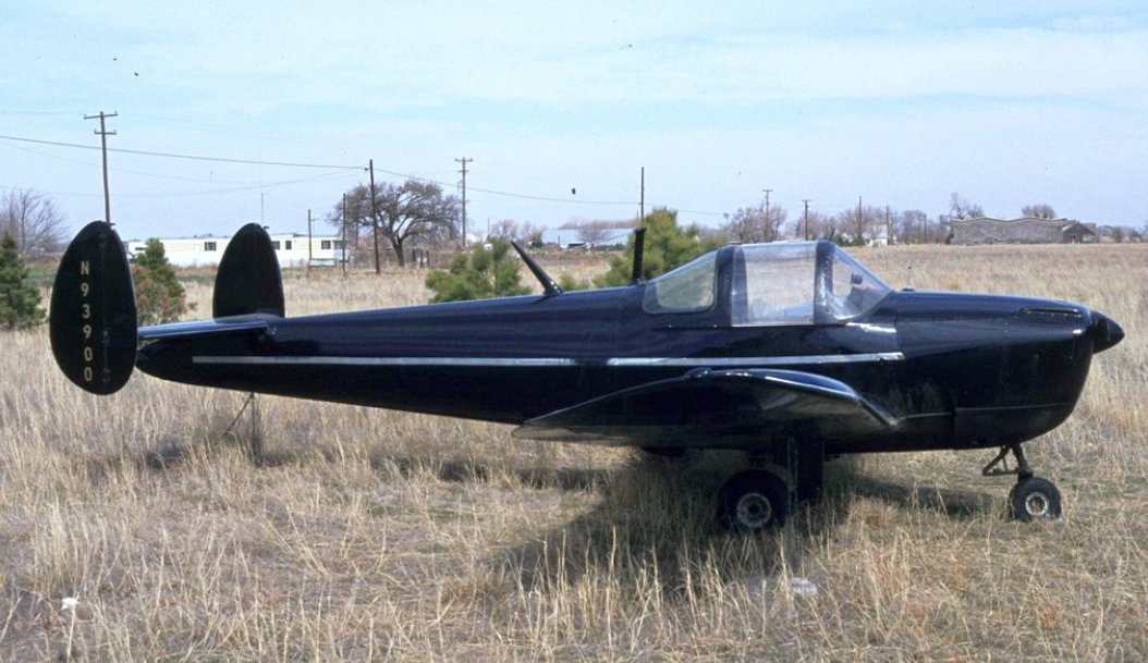
The earliest ground-level photo which has been located at Riverside Airport was a March 1981 photo of N93900, Ercoupe 415CD, construction # 1223.
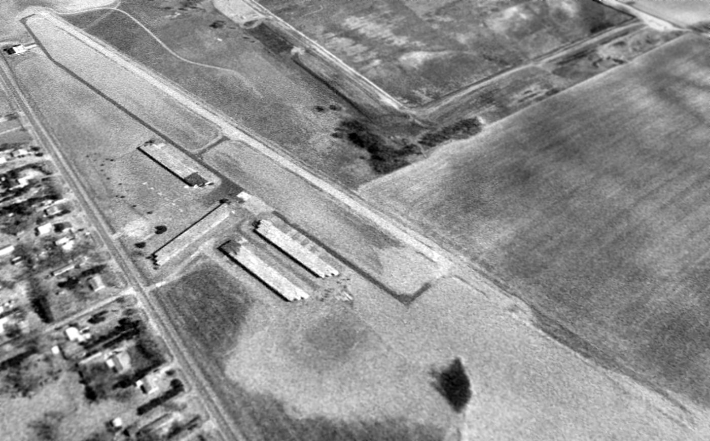
A 1996 aerial view looking northeast at Riverside Airport showed the airport to not appear very healthy, without any aircraft visible on the field.
According to an article entitled “Cornejo & Sons in process of buying Riverside Airport” by Molly McMillin in the 2/24/14 Wichita Eagle (courtesy of Dana Shifflett),
“When Tom Sanders died in 2009, his family didn’t want to manage it anymore.
Les Eck, owner of Rusty Eck Ford, bought the airport for $1.65 million in an auction of the 200-acre property in 2010.”
“I bought it because of the nostalgic value,” Eck said.
The article continued, “His plans were to repair the runway & put in a lake with houses on one side and new hangars on the other.
Eck said he spent more than $200,000 on rezoning efforts.
He also spent a lot of time on Federal Aviation Administration approvals.
As time went on, Eck learned of the city’s plans to put a water line through his property as it worked to widen Hoover Road
and to add water lines to prepare for a new city park north of the airport.”
“We knew the road was going to be widening,” Eck said. “We just didn’t know about the water lines & other stuff...
I went back for one final request, and the city told me they’re putting a water line right through the center of my plans.”
Eck also talked to airplane owners who had their planes at Riverside. “I was upfront with everybody,” Eck said.
He told them if they wanted to move their planes to feel free to do so.
“They were sad, but I felt they understood that I had given it a pretty good effort,” Eck said.
That was a year & a half ago [2012]. “I wasn’t looking to sell it,” Eck said. “I had people approach me on it.”
In the meantime, Eck said he learned a lot when it comes to airports.
“I learned there is more government red tape that you can shake a stick at,” Eck said. “My intentions were there.
“I had a plan, but it just didn’t come together,” he said. “I gave it a couple hundred thousand (dollar) effort.”
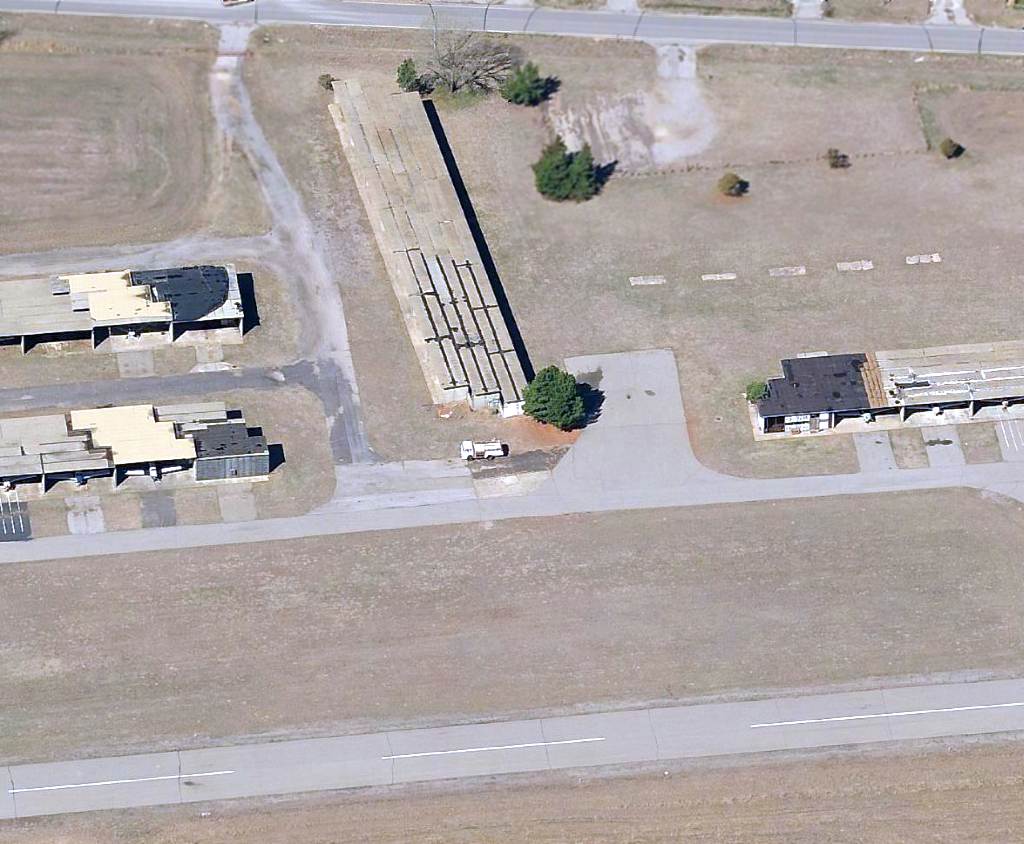
A circa 2010-2013 aerial view looking west at the ramp & hangars at Riverside Airport, showing no aircraft parked outside, and a few peeking out from the shade hangars.
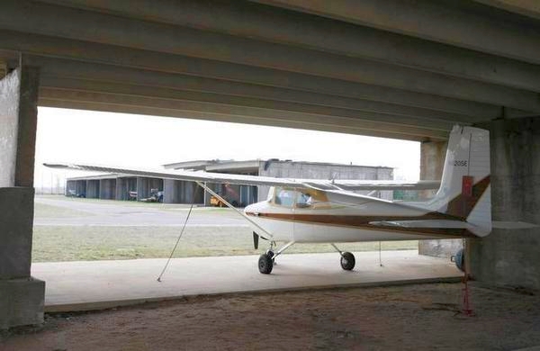
A circa 2010-2014 photo of a classic Cessna 170 inside a shade hangar at Riverside Airport.
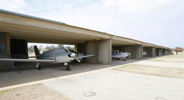
A circa 2010-2014 photo of planes inside the shade hangars at Riverside Airport.
As of 2014, Riverside Airport's FAA Airport/Facility Directory data indicated it had a 3,200' asphalt Runway 16/34,
a total of 29 based aircraft, and conducted an average of 38 takeoffs or landings / day.
The owner was listed as Fly High Inc., and the manager was listed as Les Eck
(who had passed away 5 years previously, showing how much you can trust the published data).
The 2014 Sectional Chart depicted Riverside as having a single paved 3,200' runway.
Note the presence of the Wichita Class C airspace directly overhead, which complicated operations at Riverside.
Unfortunately the end appeared to have come for Riverside Airport in 2014.
According to an article entitled “Cornejo & Sons in process of buying Riverside Airport” by Molly McMillin in the 2/24/14 Wichita Eagle (courtesy of Dana Shifflett),
“Auto dealer Les Eck has a buyer for the historic airport.
Eck has signed a deal with Ron Cornejo, CEO of Cornejo & Sons, to acquire the property.
The company intends to use the land for future sand reserves. Cornejo & Sons operates several sand mining operations.”
“Someday when we use up our existing reserves, we will move there,” Cornejo said.
The article continued, “Letters have been sent to those who had rental or lease agreements for the hangars at the airport, giving them notice about moving their airplanes, he said.
The deal has not yet closed.”
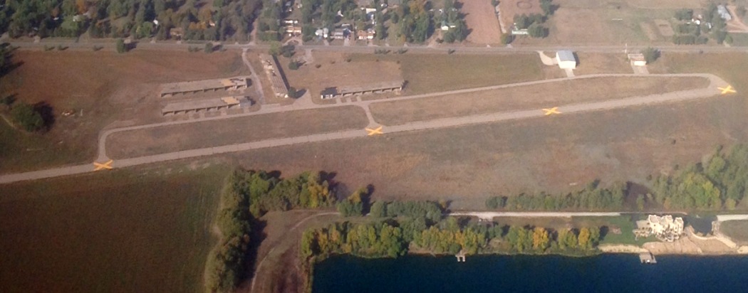
A sad 8/25/14 aerial view by Ian Beyer, showing closed-runway “X” symbols painted on Riverside's runway.
A 2015 aerial view looking northeast at Riverside Airport, showing the closed-runway “X” symbols painted on the runway.
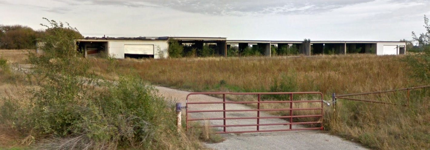
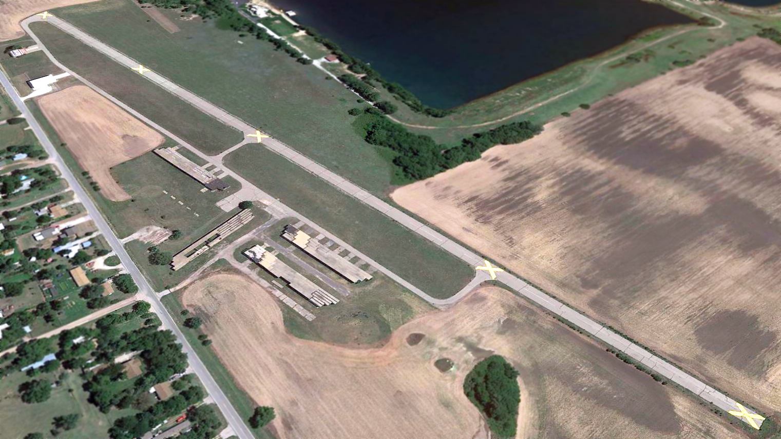
A November 2016 photo looking east at Riverside Airport's southern-most hangar.
A 2021 photo showed that most of Riverside Airport's hangars were removed between 2016-2021.
A March 2022 photo looking east at the site of Riverside Airport's southern-most hangar.

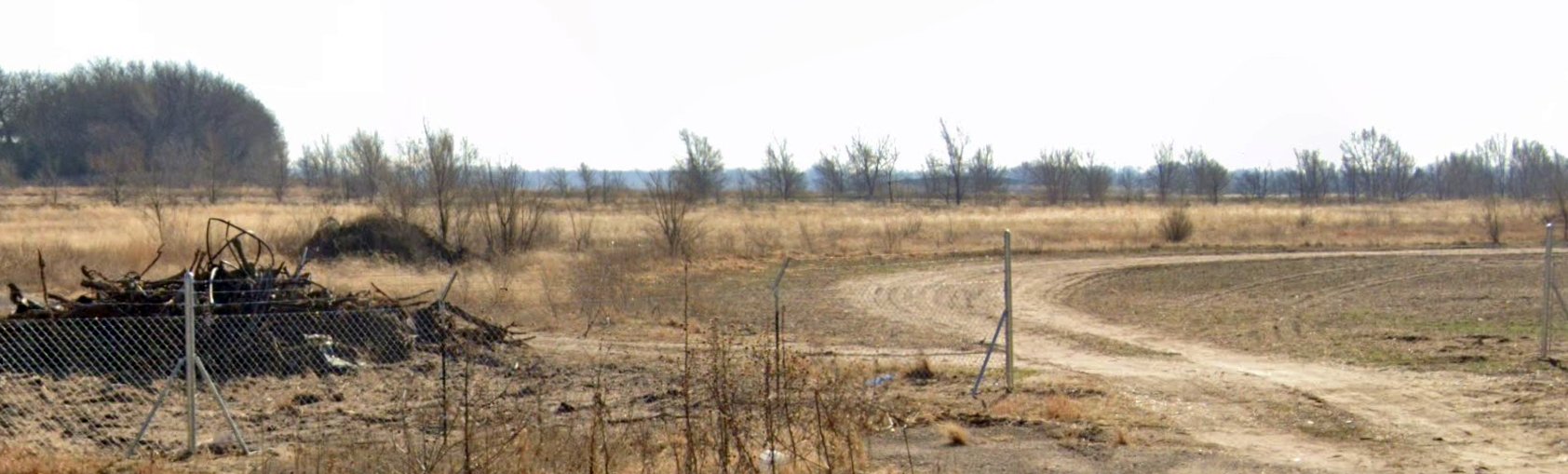
A 3/23/24 photo by Bethany Egbert looking south along the remains of Riverside Airport's Runway 16.

A 3/23/24 photo by Bethany Egbert of 2 former hangars on the northwest side of the Riverside Airport site.
Thanks to Dana Shifflett for pointing out this airfield.
____________________________________________________
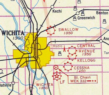
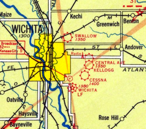
Swallow Field / United Aircraft Airfield / University Airport, Wichita, KS
37.728, -97.3 (Northeast of Downtown Wichita, KS)
A 1928 aerial view looking northeast at the Swallow Airplane Factory,
showing 2 biplanes and several hangars on the east side of a grass field.
The date of establishment of Swallow Field has not been determined.
The E.M. Laird Aviation Company Ltd eventually became the Swallow Airplane Manufacturing Company,
and designed & built light aircraft from 1923-27.
The earliest depiction of Swallow Field which has been located was a 1928 aerial view looking northeast
showing 2 biplanes and several hangars of the Swallow Airplane Factory on the east side of a grass field.
Wichita Park Cemetery was visible directly across North Hillside Street to the east.
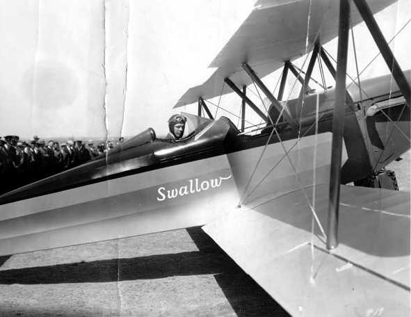
A 1928 photo of Charles Lindbergh in the cockpit of an unidentified Swallow biplane at Swallow Field.
With re-financing the doors of Swallow Aircraft opened again in 1933.
A total of 200 examples of the Swallow TP were manufactured, a remarkable quantity for that time in aviation history.
The earliest aeronautical chart depiction of Swallow Field which has been located
was on the 1933 Wichita Airway Chart (courtesy of Roger Connor),
which depicted Swallow as a commercial/municipal airport.
The last aeronautical chart depiction of Swallow Field which has been located was on the 1934 Wichita Airway Chart,
which depicted Swallow as a commercial/municipal airport.
The earliest directory listing of Swallow Field which has been located
was in The Airport Directory Company's 1937 Airport Directory (courtesy of Bob Rambo).
It described Swallow as a commercial field, encompassing 80 acres, with a 1,300' square sod field.
Buildings were said to be marked with “Swallow”.
A 1938 aerial photo depicted Swallow Field as a square grass field with a hangar on the southeast corner.
Swallow Field was evidently reopened at some point between 1937-43 under the name of “United Aircraft” Airfield,
as that is how it was depicted on the February 1943 Wichita Sectional Chart (courtesy of Ron Plante).
The 1943 USGS topo map did not depict Swallow Field / United Aircraft Airfield,
but did depict the hangar at the southeast corner.
The February 1944 Wichita Sectional Chart (courtesy of Tim Zukas) depicted United Aircraft as an auxiliary airfield.
According to the 8/15/44 Wichita Eagle, “The University Airport, at 2501 North Hillside, formerly the Swallow Field, held a formal opening yesterday.
The airport is under the direction of Eddie Ottaway & Jack Thomas.
The University airport has 1,000 acres & now has 8 level runways, each of which is half a mile or more long.”
Mary Ottaway Stokes recalled, “My dad (Eddie Ottaway) was co-owner of the University Airport.
I spent many long hours playing at the airport, and hanging out with my dad in an airplane. My mom was also a licensed pilot.”
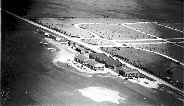
A 10/10/43 aerial view looking north at University Airport from the 1945 AAF Airfield Directory (courtesy of Scott Murdock)
depicted University as a square grass field with several hangars on the southeast side.
The 1945 AAF Airfield Directory (courtesy of Scott Murdock) described University Airport
as a 35 acre irregularly-shaped property having 4 sod runways, with the longest being the 2,696' east/west strip.
The field was said to have a single 150' x 121' brick hangar, and to be owned & operated by private interests.
Bill Schmidt recalled, “University Airport... It was probably 1946 & Cessna had already geared up
and was producing the 140-120 series airplanes as fast as they could to compete with all the other light plane producers that were filling up the G.I. Bill flight schools.
My dad was re-located to the University Airport to start converting the Cessna Bobcat / UC-78 et al to civilian use & sales.
Dad was doping fabric on the left side of a Bobcat fuselage & he swiped my hand with a big brush of nitrate dope & said to wait a bit & peel it off.
I got to ride on the planes as the men rolled them in & out of that hangar that remains there today.
Looking back I feel that those were halcyon days!”
The last aeronautical chart depiction which has been located of University Airport was on the October 1949 Wichita Sectional Chart.
It depicted University Airport as having a 2,800' unpaved runway.
The last depiction of University Airport which has been located was a 1950 aerial photo.
It depicted the field as a square grass field with a hangar on the southeast corner, and 5 single-engine aircraft visible on the field.
University Airport evidently closed (for reasons unknown) at some point in 1950,
as it was no longer depicted on the May 1950 Wichita Sectional Chart.
The 1955 USGS topo map depicted streets covering the University Airport site.
Bill Schmidt recalled, “That hangar went on to be a lot of things but most notably a site of various nightclubs of some note.
My wife attended WSU fraternity dances when the place was on the front side of it's afterlife in the mid-1960s.
From that time on it began a slow slide to rougher venues dominated by parties that constantly culminated in serious fights & many police calls.
This activity ended the hangar's use as a nightclub. The church group has a brief interlude in the late 1970s that didn't last long.”
A 1996 USGS aerial view looking north showed the majority of the site of University Airport had been covered with housing,
with the only trace being the hangar on the southeast side.
A comparison of aerial photos shows that this building on the southeast side of the airport property, depicted in a circa 2008 aerial view looking north,
is the same hangar depicted in the 1938 aerial photo.
A 2013 photo by Ian Beyer of the side of the University Airport hangar.
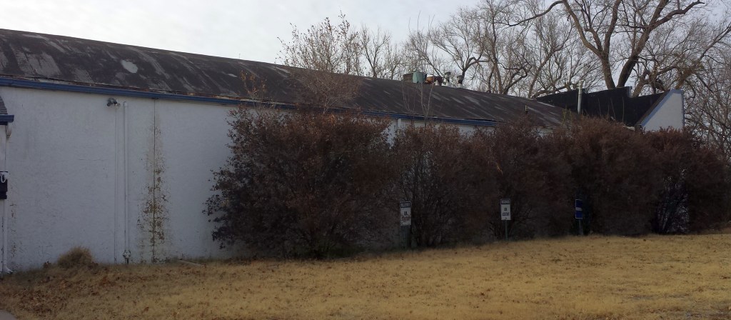
A closeup 2013 photo by Ian Beyer of the University Airport hangar.
A 2013 photo by Ian Beyer of the remains of a sign at the site of University Airport.
Bill Schmidt observed, “The lighted-type upper broken-out sign is a remnant from the nightclub days.”
The “Victory Temple” on the lower sign is a remnant from the hangar's reuse by a church in the 1970s.
A 2015 aerial photo shows that the majority of the site of University Airport has been covered with housing,
but amazingly the hangar on the southeast side remained standing after more than 77 years.
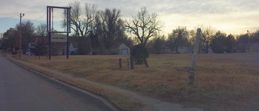
Bill Schmidt reported in 2016, “The old University Airport hangar on North Hillside has been renovated & is quite spectacular.”
A 3/20/17 photo by Bill Schmidt of the former University Airport hangar.
Bill observed, “Once again it has become a church with a tremendous facelift & a nice new sign.”
The site of University Airport is located southwest of the intersection of 25th Street & Hillside Street.
____________________________________________________
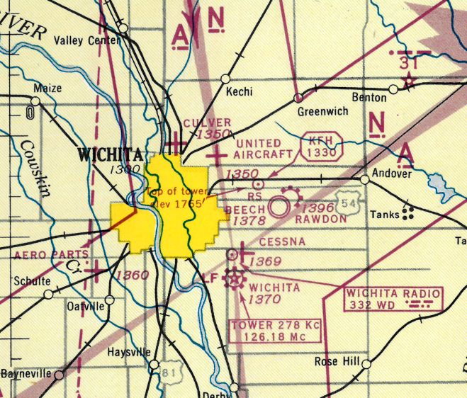
Buckley Aircraft Airfield / Rawdon Field / Copeland Field / Beech North Airport (K31), Wichita, KS
37.7, -97.21 (East of Downtown Wichita, KS)
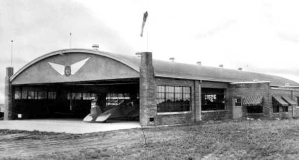
A circa 1929-31 photo of the Buckley Aircraft Company hangar.
Walter House reported, “The Rawdon Field main hangar was originally built by the Buckley Aircraft Company in 1929–1930.”
The Buckley Aircraft Company was formed by Roy Buckley in late 1929 at Wichita,
and it produced only 2 aircraft that were designed by well-known William Stout: the FC-1 of 1929 & the LC-4 of 1930.
The FC-1 was a 2-seat monoplane powered by a Kinner K-5.
It had an all-metal fuselage of chromoly welded tubing covered with a corrugated aluminum skin.
The 4-seat all-metal LC-4, powered by a 300 hp Pratt & Whitney Wasp Junior radial engine,
was designed as an aerial taxi, and the Yellow Air Cab Company signed a contract for 200 aircraft.
The aircraft received its ATC (Approved Type Certificate) number 2-359 on 6/13/31,
however, NC499W was the sole example produced, and was sold to Northrop.
The earliest photo which has been located of the Buckley Aircraft Company was a circa 1929-31 photo of a hangar.
A circa 1929-31 photo of the Buckley Aircraft Company “factory” & hangar in the background,
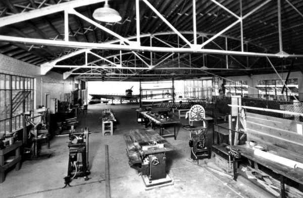
A circa 1929-31 photo of the interior of the Buckley Aircraft Company hangar.
The Buckley Company folded under the Depression in 1931.
No airfield at this location was depicted on Wichita Sectional Charts from 1933/35/37/39/40.
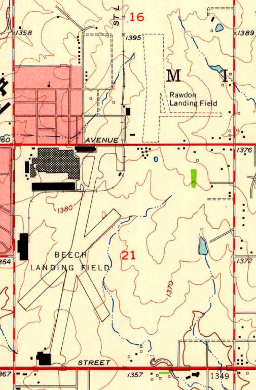
This property was next the home of Rawdon Brothers & Rawdon-Burnham Company, an aircraft manufacturing firm.
Herb Rawdon had been the chief designer of Travel Air, and later Beech Aircraft in Wichita, Kansas.
He left Beech & in 1938 established the firm, with his brother Gene Rawdon, with their factory located near the Beech aircraft plant.
Dutch Rawdon was the company pilot.
The date of construction of Rawdon Airport is unknown.
A 1938 aerial photo depicted Rawdon Field as a rectangular grass area with a single hangar along the west side (the previous Buckley Aircraft hangar).
No aircraft were visible on the field.
The Rawdon R-1 aircraft was designed by Herb Rawdon in 1938 & a single example was built.
It was a single-engine twin-seat side-by-side open cockpit low-wing training monoplane powered by a 75 HP Lycoming engine.
It had a maximum speed of 110 MPH & a cruising speed of 105 MPH.
The R-1 was not accepted as a trainer by the U.S. Army Air Corps & it was modified as a crop spraying aircraft.
According to the Kansas Aviation Museum, the Rawdon Brothers Flying Service was organized in 1940
as a partnership for the purpose of running a flight school, operating a commercial airport, and performing related flying services.
According to Richard Harris, “Herb Rawdon was one of the city's preeminent aircraft engineers
(with partner Walter Burnham, he'd designed Travel Air's legendary Mystery Ship racer & Dole Race victor 'Woolaroc'),
and had been chief engineer at Beech, until apparently falling out of favor with its finicky grand dame, Olive Ann Beech.
He moved to his own operation across Central Avenue from Beech, and tinkered on various projects, for himself & other companies.”
The earliest aeronautical chart depiction of Rawdon Field which has been located was on the August 1941 Wichita Sectional Chart (courtesy of Chris Kennedy).
It depicted Rawdon as a commercial airport.
The earliest photo which has been located of Rawdon Airport
was a 10/10/43 aerial view looking north from the 1945 AAF Airfield Directory (courtesy of Scott Murdock).
The 1945 AAF Airfield Directory (courtesy of Scott Murdock) described Rawdon Airport
as a 110 acre L-shaped property having 2 sod & sand 2,200' runways, oriented north/south & east/west.
The field was said to have a single 120' x 65' brick & stone hangar,
and to be owned & operated by private interests.
Rawdon Airport was not depicted at all on the 1945 USGS topo map.
The 1945 Wichita Sectional Chart (courtesy of Chris Kennedy) depicted Rawdon as a commercial airport.
According to the Kansas Aviation Museum, Rawdon Brothers Aircraft Inc.
was incorporated while in facilities on Rawdon Field on 7/1/47,
with the partners of Rawdon Brothers Flying Service serving as principal stockholders.
The Corporation continued with the flying school & airport activities.
It also established a small factory for the production of aircraft parts & assemblies.
The Rawdon T-1 aircraft was developed from the original Rawdon R-1.
The aircraft secured CAA approval in September 1947, but was not immediately placed into production.
It was a tandem-seat closed cockpit low-wing monoplane, powered by Lycoming engines of between 125-150 HP.
The T-1 was built in 5 versions & was used for training, crop spraying, aerial advertising and other utility roles.
Bob Heath reported, "I own a J-3C-65 Cub that was once owned by the Rawdon Brothers
and operated out of Rawdon Field in January-November 1948."
In 1948 the company started the manufacturing of aircraft parts,
then in 1949 began producing parts for crop spraying equipment for installation on war surplus Stearman airplanes.
When the Korean Conflict began, the federal government was again interested in purchasing aircraft.
Rawdon was extensively involved in producing aircraft sub-assemblies,
including wing panel assemblies, tail surface assemblies, pilot seats,
cabin doors, windshields, and other furnishings for the Cessna L-19 Bird Dog.
The company produced a number of conversions for the PT-17, BT-13, BT-15,
and even the Beech Model 35 Bonanza which were authorized under the Type Certificate of the airframe manufacturer.
The Company also worked as a sub-contractor for Continental Can as a primary contractor for the Air Force.
During this time Rawdon accumulated valuable experience in production techniques.
The design for the Company airplane was continuously revised,
awaiting the time when conditions were appropriate to introduce it to the market.
A few airplanes were produced & sold to friends of the company.
Crop spraying equipment was designed and added to the airplanes.
A metal wing was designed to replace the fabric covered wing.
Engines of 135, 150, and 180 HP were also certified.
The airplane was sold as a general trainer, aerobatic trainer, and crop duster.
Some airplanes were sold to foreign countries for use as trainers for military pilots.
The 1949 KS Airport Directory (courtesy of Chris Kennedy)
depicted Rawdon as having 3 sod runways, with the longest being the 2,550' northwest/southeast strip.
Four buildings (hangars?) were situated on the southwest corner of the field.
The airport was said to offer repairs & fuel, and the manager was listed as Gene Rawdon.
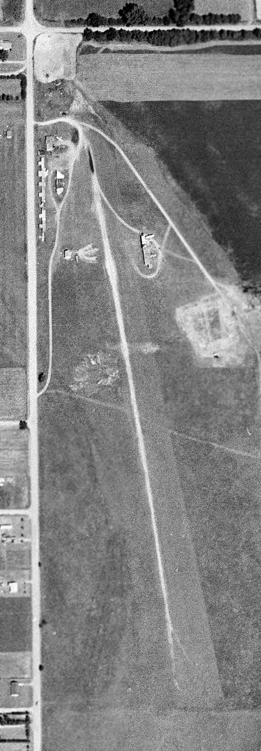
A 1950 aerial photo showed Rawdon Field to consist of a rectangular grass area,
with 25 light aircraft clustered around a hangar on the west side.
The 1956 USGS topo map depicted “Rawdon Landing Area” as having 2 unpaved runways with 2 buildings along the southwest side.
Jim Wickham recalled, “My father personally knew the Rawdons as he worked at Boeing Stearman from about 1938-50.
Rawdon Field did not have a paved field the summer 1959, the last time that my dad landed there in the Bluebird.
Also at that time there a couple of the Rawdon tandem 2-seat low wings were in their hangar.”
A 9/13/60 USGS aerial view depicted Rawdon Field as having 2 unpaved runways, with 2 buildings, a row of T-hangars, and 16 single-engine aircraft along the west side.
A total of 35 examples of the Rawdon T-1 completed before the production line was closed in the 1960s.
According to Richard Harris, “Rip Gooch, who developed & owned the Fixed Base Operation (aircraft dealership, repair shop, and flight school) at Rawdon -
Aero Services, Inc. - for several years during the 1950s & 1960s, was a pioneer black aviator,
becoming one of the first African-Americans to own a successful FBO.
He rented the south Quonset-hut building (built in WWII).
With his airport just across the street from mighty Beech Aircraft Company,
he had the audacity to open one of the first (and most successful) Mooney Aircraft regional distributorships (not just a dealership) -
which remained, even after the field was bought by a dentist named Copeland.”
The runway at Rawdon was evidently paved at some point between 1959-65,
as the 1965 Wichita Sectional Chart (courtesy of John Price)
described the field as having a single 2,500' paved runway.
Bill Scmidt recalled, “I learned to fly in 1965 at Rip Gooch's Rawdon Field under the Air Force ROTC program that Rip had captured the contract for.
I bought a run-out Piper PA-16 Clipper that I restored.
I was one of the hobbyist / homebuilders that were mentioned in the Rawdon story.
I could walk in there anytime and use the shears, saws, crimpers and even the English Roll with no charge. Can you imagine this today! Liability?
Herb Rawdon only wanted to sit in his little building in back & do engineering work for Lockheed, Douglas & Boeing.
These companies would fly him to CA for consulting work all the time.
The actual shop functions were left to an old crippled man named Harold Johnson & the experimental actual work in the shop was headed by able George Packard.
They were involved in engine conversions on old Beech 18s.
This consisted of sticking Lycoming TIGO 540s (straining to produce 450hp) in a new mount & flat cowling that really upped the efficiency of the wing in the engine area.
They got an STC no sweat with Herb doing the engineering.
Money was supplied by a rich Texan named Bill Bessler.
There was still one partial Rawdon T-1 fuselage still fixed in the welding jig all this time.”
Bill continued, “Next they were well into slipping a Lycoming IO-720 8 cylinder into another Beech 18 when Herb died & things went to pot rapidly.
Herb's big verbose son took over the operation wanting to turn it into a big money maker, and things rapidly fell apart.
He had a physical confrontation with old, crippled Harold & threw everyone out.
That last Beech 18 was shoved outside & the KS wind blew it to the North down field & into pieces.
Rip Gooch was long gone after his government contract to rebuild UH-1 helicopter blades failed.
Soon the whole thing was sold to Beechcraft and the playpen was over, but I'll always remember the wonderful time.
Bill continued, “Lastly, there was a complete Vought F4U-2 Corsair sitting on the field that was abandoned when the pilot/owner flew in,
out of gas from the surplus sales in AZ & had no money to fuel it up.
He got a bus ticket & went home back East leaving the Corsair to sit.
Harold offered it to me free with a sales paper if I would haul it off! Gads! There was no way to do so for me.
A local Wichita scraper got it & cut it up. The P&W R-2800 laid at the junkyard entrance for several years & made me grimace & avoid the street for some years.”
Dean Hartschen recalled, “I learned to fly from Rawdon Field & worked at Aero Services Incorporated, which was the FBO on the field, from 1967-73.
While I was there I talked to people like Herb Rawdon, and Glen Stearman & several other people that later started business in the aviation field.
Some of the people at Aero Services Incorporated are the ones which got the Wichita police department to use a helicopter.
Another person at Aero Services Incorporated later moved on to start the Life Watch program in Wichita.
The runway was paved before I started to work there in 1967 & there were 2 crosswind grass runways
with several T-hangars along the west property boundary along the railroad track.
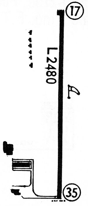
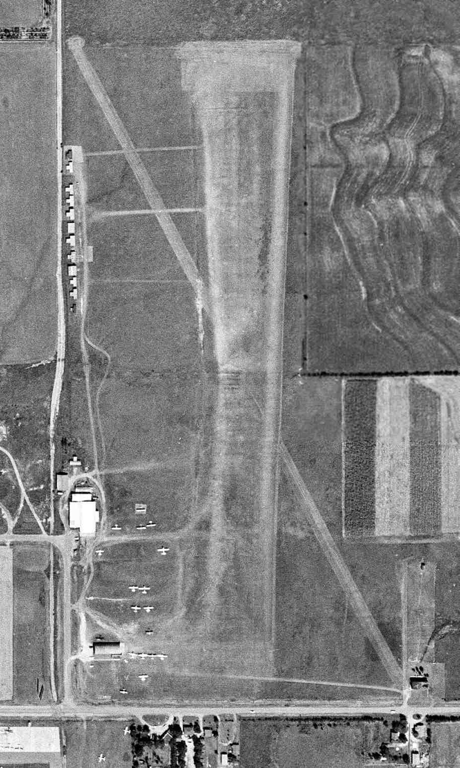
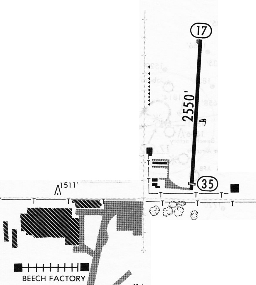
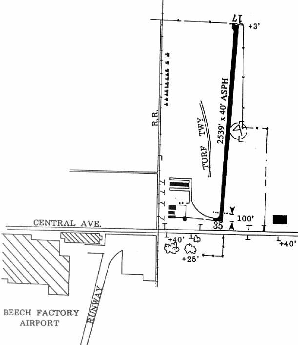
The 1968 Flight Guide (courtesy of Robert Levittan) depicted Rawdon Field as having a single 2,480' paved Runway 17/35,
with a row of 6 T-hangars on the northwest side, and a taxiway, ramp, and 3 larger buildings on the southwest side.
According to Richard Harris, “For a while in the 1960s, Rawdon's only workman was Kenny Isely
who (with Rawdon) did aviation product-development craftsmanship for Homer Jones' development company.
Rawdon died in the late 1960s / early 1970s.
Isley rented a vacant corner on the airfield's west side to build an ice rink around 1970.
Mr. Isely reports that a number of homebuilders/tinkerers were based on Rawdon Airport,
and occupied about 6-7 hangars along the west side, towards the north end of the field.”
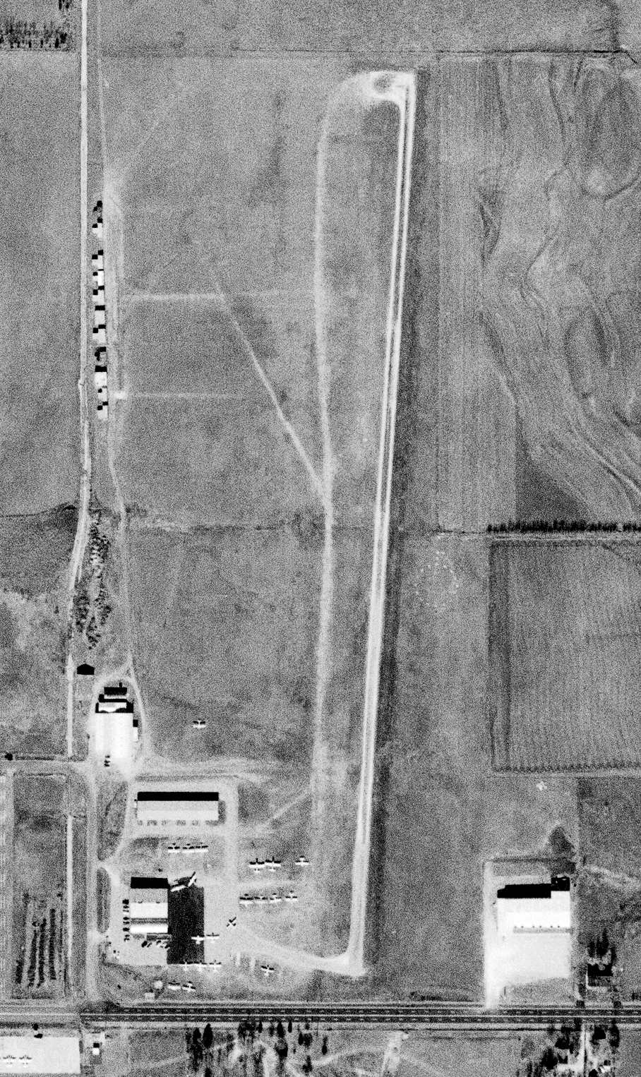
The last photo which has been located showing Rawdon Field still open was an 11/23/70 USGS aerial view.
It depicted Rawdon as having a single north/south paved runway, with a building having covered the southeast portion of the previous crosswind runway.
A large number of light aircraft were parked near the hangars on the southwest side, and the row of T-hangars remained on the northwest side.
The 1971 Wichita Sectional Chart (courtesy of Vince Granato) depicted Rawdon as having a single 2,500' paved runway.
According to Richard Harris, “The Rawdon family apparently kept the field until about 1973.”
The Rawdon company reportedly continued in operation until 1978, when it became Spinks-Rawdon in Fort Worth, Texas.
The last photo which has been located showing Rawdon Field in operation was a 1981 aerial view.
It depicted a single asphalt Runway 17/35, with a group of hangars & several light aircraft on the southwest side.
At some point between 1971-82, the field was renamed Copeland Airport,
as that is how it was listed in the 1982 AOPA Airport Directory (courtesy of Ed Drury).
It was described as having a single 2,550' asphalt Runway 17/35,
and listed the operators as Copeland Aviation Inc. & Flight Specialists Inc.
In addition to the single runway, the 1982 USGS topo map depicted a taxiway,
a small ramp area & a set of small hangars at the south end of the runway.
Dean Hartschen recalled, “When Copland had the facility they added a hangar to the north of the existing hangars
and then when Beech/Raytheon purchased the property another hangar was added on the north side of the Copland hangar.
The Beech Control tower was moved to the west of those hangars when the new runway went in & Rawdon Field disappeared.”
According to Richard Harris, “In the 1980s, Copeland (or subsequent owners) sold out to Beech Aircraft (by then renamed 'Raytheon Aircraft Division')
who wanted the field to expand their runway (important, since Raytheon had acquired the Hawker business line,
which often required more runway than Beech Field had).”
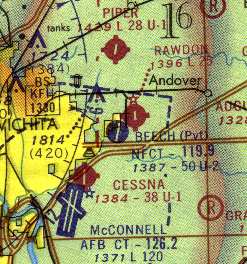
At some point between 1982-83, the airfield was renamed “Beech North Airport”, after having been purchased by Beechcraft,
as that is how it was depicted on a 11/18/83 airport directory (courtesy of John Kielhofer).
It depicted Beech North Airport as having a single 2,550' paved Runway 17/35.
The 1986 AOPA Airports USA Directory (courtesy of David Brooks)
described Beech North Airport as having a single 2,550' asphalt Runway 17/35.
The last aeronautical chart depiction which has been located of Beech North Airport
was on the 1992 Wichita Sectional Chart (courtesy of Ron Plante).
It depicted Beech North Airport as having a single 2,500' paved runway.
The 1994 KS Airport Directory (courtesy of David Brooks)
depicted Beech North Airport as having a single 2,539' asphalt Runway 17/35,
along with a ramp at the southwest end with several hangars.
The diagram also depicted the proximity of the Beech Factory & its runway, just across Central Avenue to the southwest.
The field was described as consisting of a total of 62 acres,
and the remarks said, “Fuel & assistance available at Beech Factory Airport.”
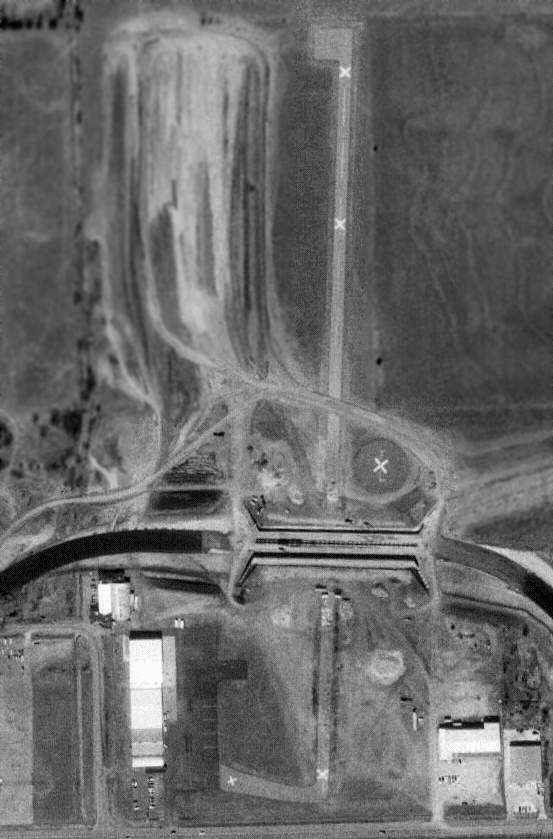
Beech North Airport was apparently closed at some point between 1994-96,
as the 1996 USGS aerial picture showed that portions of the runway had been covered by construction,
making way for an expansion of the runway of the Beech Factory Airfield, which sits adjacent to the south.
The majority of the length of the former runway was still visible, marked with closed-runway "X" symbols,
although the center portion of the runway had been bisected by construction.
Several hangars were visible at the southwest corner of the former airfield, having been added at some point between 1950-96.
Beech North Airport was no longer depicted on the 1999 Wichita Sectional Chart.
A 2000 aerial photo showed that the former airport was covered by a new runway of Raytheon (Beech) Airfield,
which extended across Central Avenue.
It also showed 3 Raytheon Starships sitting on the ramp to the east of the Rawdon hangar.
The Starships had been repurchased by Raytheon after the Starship program was canceled,
with the intent of destroying them to eliminate liability.
John Davis reported in 2005, “This airfield is now totally incorporated in the Raytheon (Beech) Airfield;
which is why it does not appear - even on sectionals.
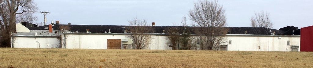
One, or two, of the buildings still stand - in use by Raytheon.”
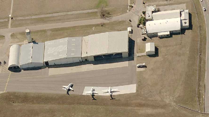
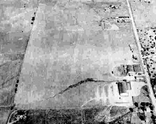
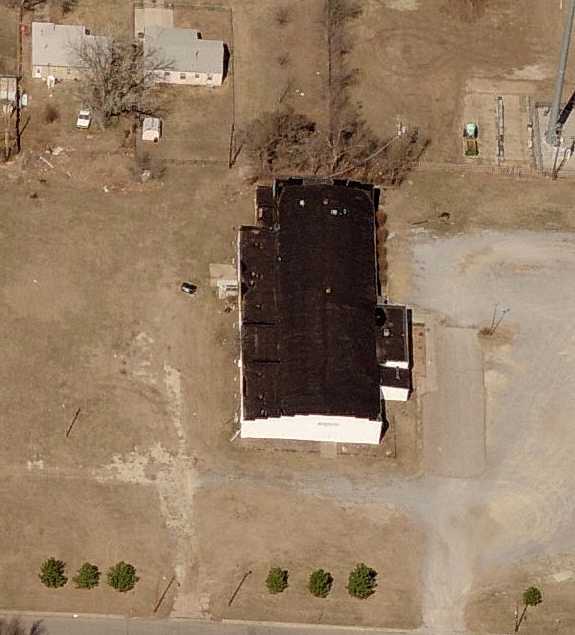
A circa 2006 aerial view looking west at hangars from the former Beech North Airport, now reused as part of the new Raytheon Airport.
Dean Hartschen reported in 2006, “The original Rawdon hangar is still in use by Raytheon Aircraft.
There are still two of the original Aero Service hangar standing and in use also.”
A 2008 aerial view showed the former Rawdon hangar still remained standing.
Richard Harris reported in 2009, “Today, only a few of the original buildings remain,
along with many newer hangars built by Raytheon Corporation,
before selling out their Aircraft Division to Onex Corporation (who renamed it 'Hawker-Beechcraft Corporation').”
____________________________________________________
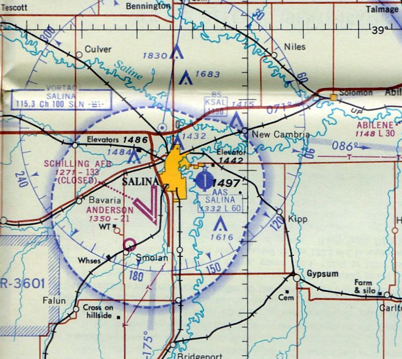
(Original) Salina Airport, Salina, KS
38.82, -97.57 (Northwest of Wichita, KS)
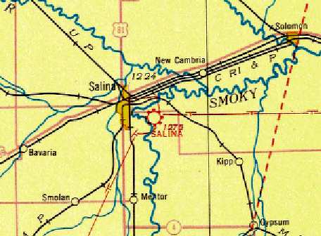
The Salina Airport, as depicted on the 1933 Salina Sectional Chart (courtesy of Scott O'Donnell).
The municipal airport for the town of Salina was originally located east of the city.
The Salina Airport was opened on 7/24/29, as indicated on a trophy presented to George Halsey (according to Thomas Mackel, his great-grandson).
The earliest depiction which has been located of the Salina Airport was on the 1933 Salina Sectional Chart (courtesy of Scott O'Donnell).
Airline service was provided at Salina Airport by Continental Airlines & Central Airlines.
The earliest photo which has been located of the Salina Municipal Airport
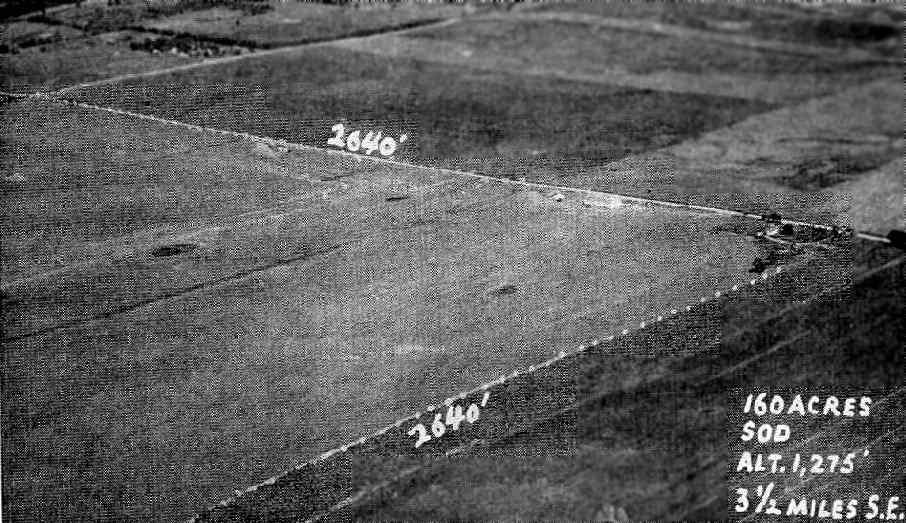
was an undated aerial view in The Airport Directory Company's 1938 Airport Directory (courtesy of Chris Kennedy).
It described the Salina Municipal Airport as having a total of 4 sod & clay runways,
with the longest being a 2,600' northwest/southeast strip.
A 10/8/43 USAAF aerial view looking north (from the National Archives, courtesy of Brian Rehwinkel)
depicted Salina Municipal Airport as having 3 unpaved runways.
The 1945 AAF Airfield Directory (courtesy of Scott Murdock) described Salina Municipal Airport
as a 160 acre square property having 4 sod runways, the longest being the 2,590' north/south & east/west strips.
The field was said to have 3 wooden hangars, the largest being a 100' x 50' structure.
Salina Municipal Airport was described as being owned by the City of Salina, and operated by private interests.
The 1949 KS Airport Directory (courtesy of Chris Kennedy)
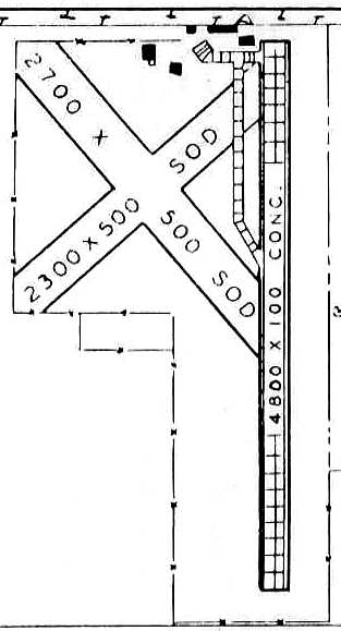
depicted Salina Municipal Airport as having a single 4,800' concrete north/south runway,
along with 2 shorter sod runways along the northwestern corner of the field.
A paved taxiway along the western side of the concrete runway led to 5 buildings (hangars?) on the northern edge of the field.
The airport was said to offer repairs & fuel, and the manager was listed as C. I. Aspergen.
The last photo which is available showing the Salina Municipal Airport still in operation was a 7/27/54 USGS aerial view.
A dozen light aircraft were visible parked on the northwest side.
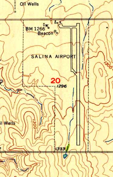
The 1955 USGS topo map depicted Salina Airport as having a paved north/south runway,
with a ramp leading to several small buildings & a beacon on the northwestern corner of the field.
A 1957 aerial view depicted the long concrete north/south runway,
along with several hangars & light aircraft on the north side of the field.
A set of 3 T-hangars was located on the northwest side of the field, arranged southwest/northeast.
A 1958 aerial view showed that the ramp on the north side had been expanded at some point within the preceding year, along with a few more hangars.
A DC-3 was visible on the ramp.
Bill Fusselman recalled, “In 1961-65 I was stationed at Shilling AFB.
I got my Private Pilot certificate through the Shilling AFB aero club.
We used the (original) Salina Municipal Airport for some of our practice (pre-solo, solo, etc.).
I solo'd there & also did my private pilot check ride there on 10/26/63. The examiner's name was Clifford Vogan.”
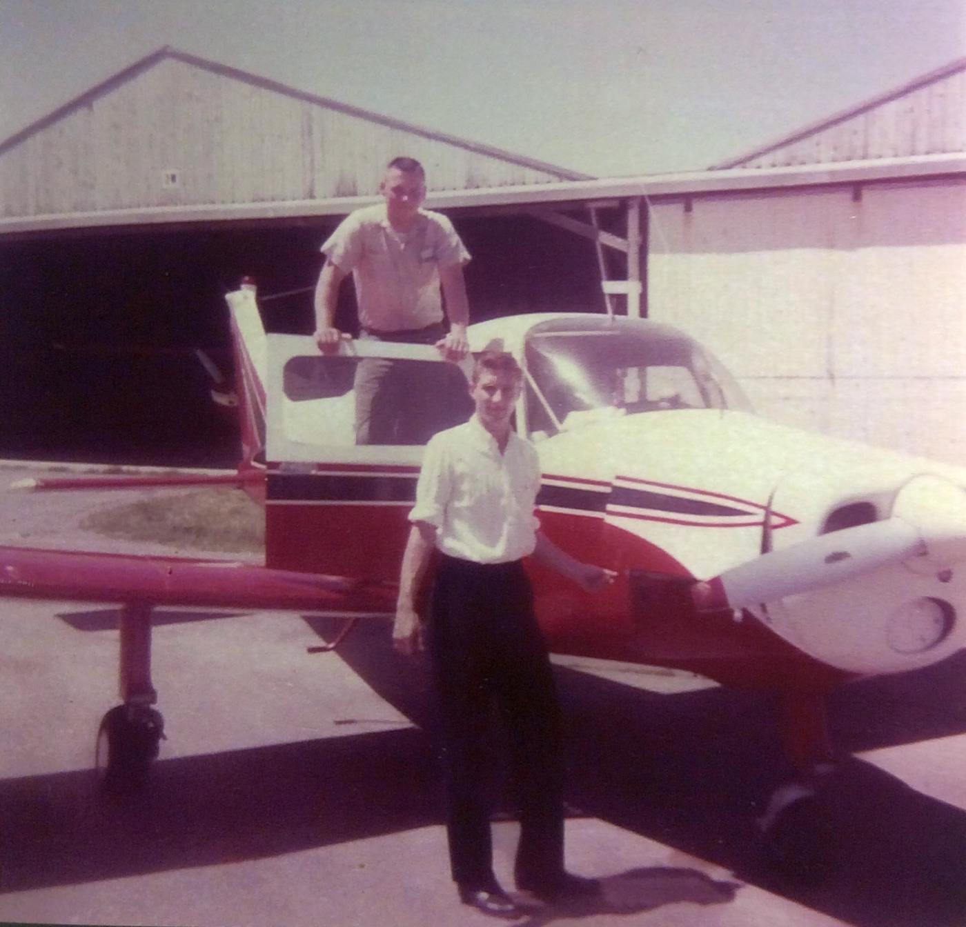
The last photo which has been located showing the original Salina Municipal Airport in operation
was a photo which Bill Fusselman recalled “was taken in Summer 1964. I am in the foreground, checking the engine.
The other guy was an unnamed airman from Schilling whom I was taking for a flight.
In 1964, Air Force Flight Surgeon, Dr. Terry Poling & I informally leased the pictured 1962 Beechcraft Musketeer.
We brought it to Salina & kept it at the (original) Salina Airport from Spring 1964 until it sold some time near December 1964.”
According to Bill Fusselman, “Schilling AFB closed in June [1965] and became the new Salina Municipal Airport soon after.”
The last depiction which has been located showing the original Salina Airport still open
was on the September 1965 Salina Sectional Chart (courtesy of Ron Kunse).
It depicted Salina as having a 6,000' paved north/south runway.
The original Salina Airport was evidently closed at some point between 1965-66,
as a 1966 aerial view showed that closed-runway “X” markings had been painted along the runway,
but the airfield otherwise remained intact.
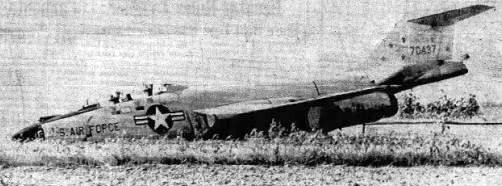
An undated photo (from the 8/3/67 Decatur Review, courtesy of Joseph DuPont) of an Air Force McDonnell F-101B Voodoo fighter
which was heavily damaged after an emergency landing at the abandoned Salina Airport.
The crew, from Schilling AFB, was not injured, but the Voodoo suffered a collapsed nose gear.
Mike Hamblin lived in Salina from 1967-68.
He recalled, “The original Salina Airport... in the late 1960s
was used as an auxiliary helicopter base by the U.S. Army out of Ft. Riley (the 1st Air Cavalry).
I remember my cousin telling me about it during an airshow at Schilling & later I went there to see for myself.
I observed about 7-8 UH-1s parked on the ramp.”
The original Salina Airport was depicted as an abandoned airfield on the June 1970 Wichita Sectional Chart (courtesy of Stu Sibitzky).
A 1973 aerial photo showed that the 3 T-hangars on the northwest side had been removed at some point between 1966-73,
but the runway & hangars otherwise appeared to remain intact.
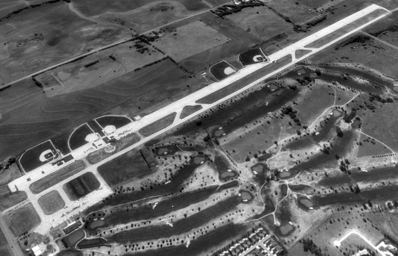
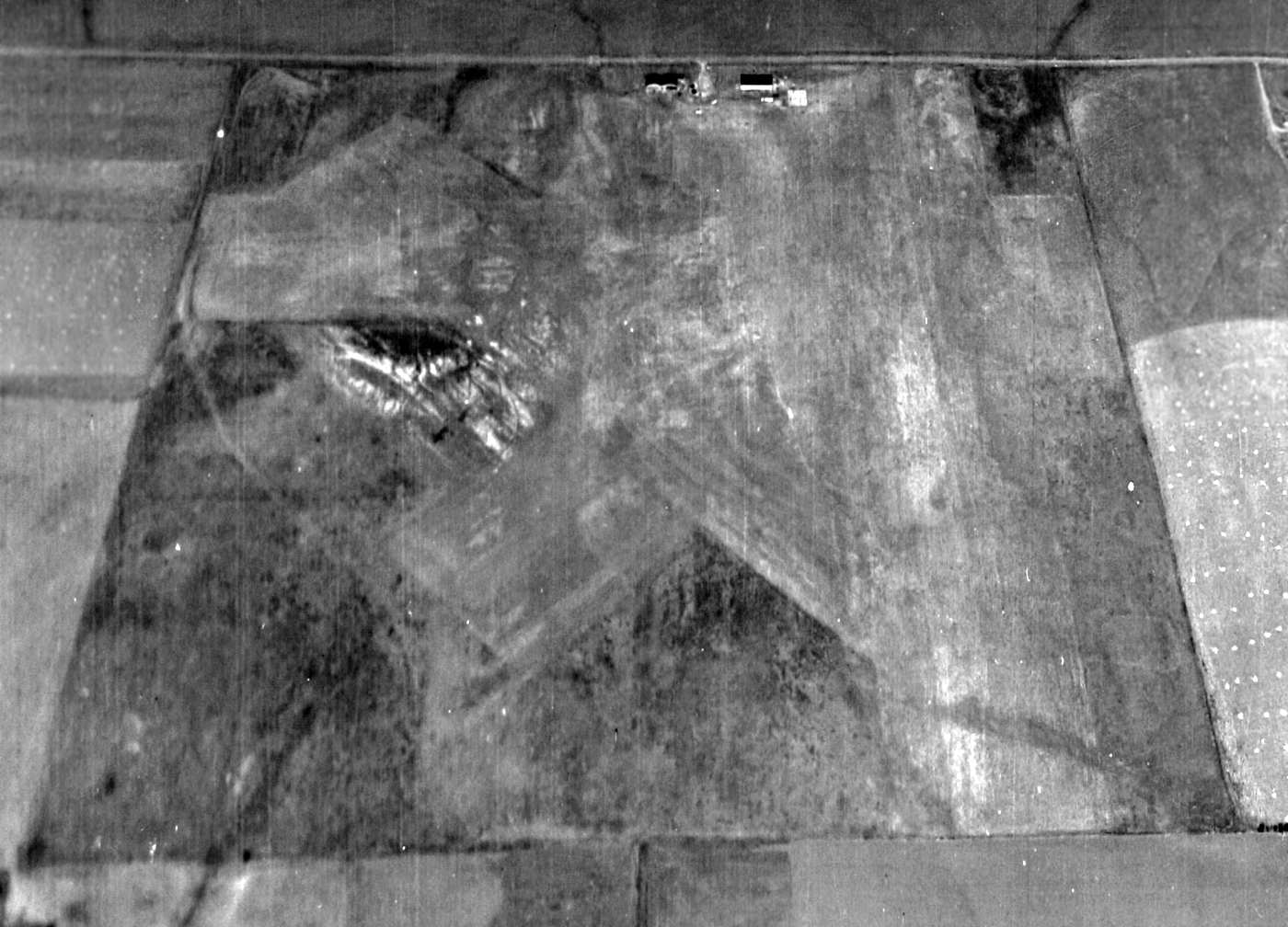
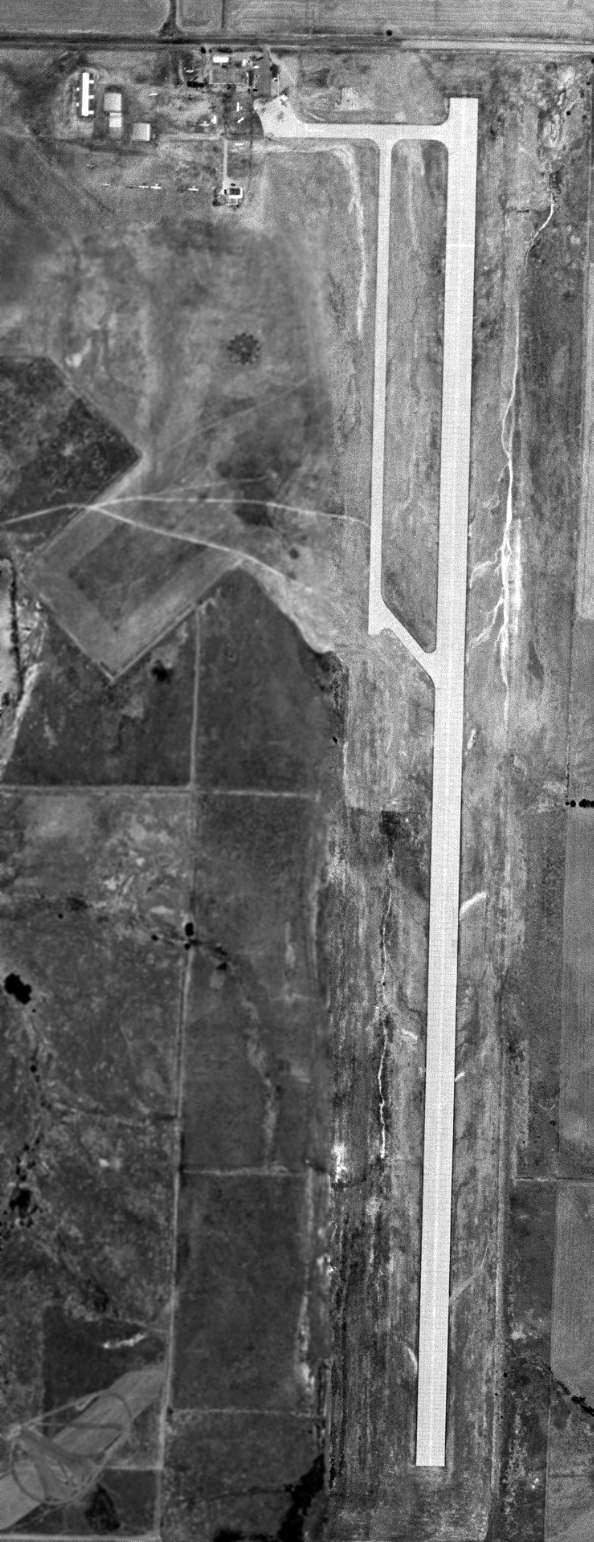
A 1991 USGS aerial view looking southeast at the site of the original Salina Airport showed several baseball diamonds had been built along the paved runway,
and the area of the former grass runways to the west had been converted into a golf course.
Senior Airport Planner Brad Weisenburger recalled, "I went to college in Salina & worked at the golf course that is next to the ball fields.
The parallel taxiway is now Markley Road, it connects Crawford Street on the north to Magnolia Street on the south.
The former commercial passenger terminal building is the golf course clubhouse.
One former hangar remains; it is used for equipment for the golf course.
The former apron area is parking for the golf course."
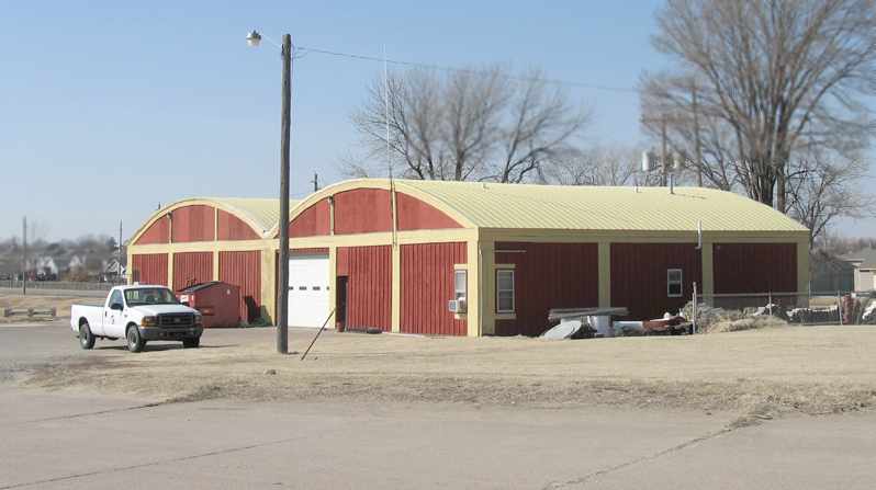
A 2006 photo by Jon Karkow, looking northwest at the former hangars which remain at the site of the original Salina Airport.
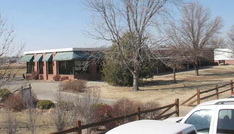
A 2006 photo by Jon Karkow, looking northwest at the former terminal building at the site of the original Salina Airport.
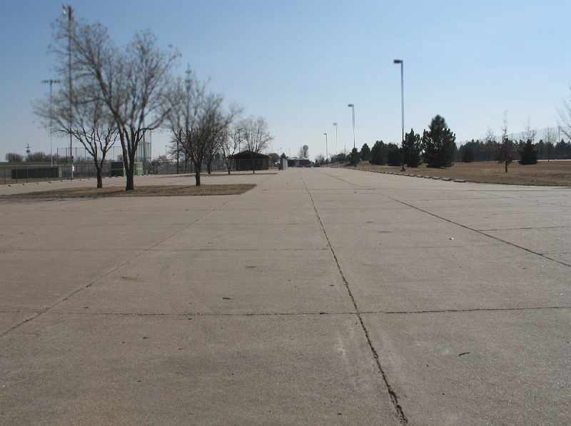
A 2006 photo by Jon Karkow, looking south from the north end of the former runway at the site of the original Salina Airport.
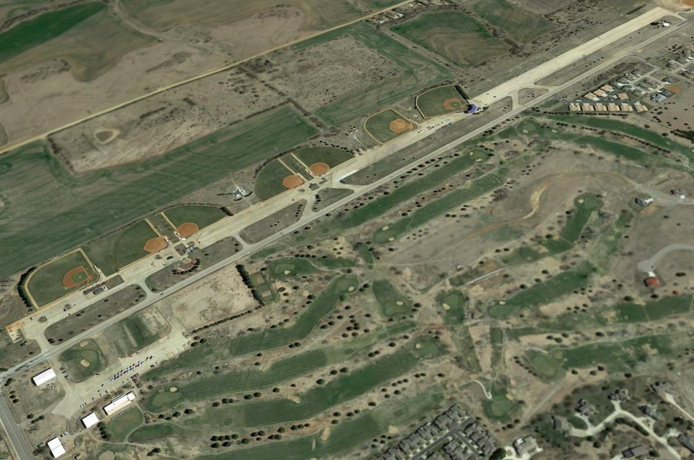
A 2014 aerial view looking southeast at the remains of the original Salina Airport.
Thanks to John Vickers for contributing information about this field.
____________________________________________________
Since this site was first put on the web in 1999, its popularity has grown tremendously.
If the total quantity of material on this site is to continue to grow,
it will require ever-increasing funding to pay its expenses.
Therefore, I request financial contributions from site visitors,
to help defray the increasing costs of the site
and ensure that it continues to be available & to grow.
What would you pay for a good aviation magazine, or a good aviation book?
Please consider a donation of an equivalent amount, at the least.
This site is not supported by commercial advertising –
it is purely supported by donations.
If you enjoy the site, and would like to make a financial contribution,
you
may use a credit card via
![]() :
:
Please consider checking the box to make a monthly donatation.
For a mailing address to send a check, please contact me at: paulandterryfreeman@gmail.com
If you enjoy this web site, please support it with a financial contribution.
please contact me at: paulandterryfreeman@gmail.com
If you enjoy this web site, please support it with a financial contribution.
____________________________________________________
This site covers airfields in all 50 states.