Abandoned & Little-Known Airfields:
Northern Illinois
© 2004, © 2024 by Paul Freeman. Revised 4/13/24.
This site covers airfields in all 50 states: Click here for the site's main menu.
Please consider a financial contribution to support the continued growth & operation of this site.
Clarence C. Johnson Field (revised 4/13/24) - Earlville Airport (revised 10/18/22) - Galesburg Airport (original location) (revised 7/27/23) - Kankakee River State Park Airfield (added 11/27/20)
Lincoln Airport / Bock Airfield (added 3/1/23) - Ottawa Airport / Skydive Chicago Airfield (revised 8/20/21) - Piper Airport (revised 3/1/23) - (Original) Rockford Airport / Machesney Airport (revised 10/20/22)
South Beloit Airport (revised 10/15/21) - Starved Rock Airpark (revised 8/3/23) - Sycamore Airport (revised 9/5/23) - Wagon Wheel Airport (revised 10/21/22)
____________________________________________________
40.157, -89.397 (Southwest of Chicago, IL)
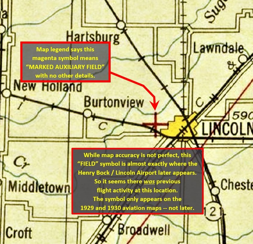
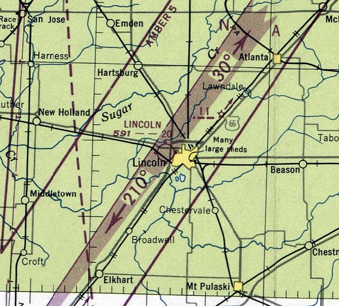
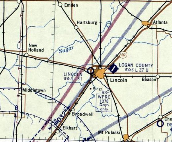
Lincoln Airport, as depicted on a 1929 Strip Chart aeronautical chart (courtesy of John Fuller).
The earliest depiction which has been located of Lincoln Airport was on a 1929 Strip Chart aeronautical chart (courtesy of John Fuller).
It depicted an auxiliary airfield, west of the town, in the same location which will eventually become the site of Lincoln Airport / Bock Field.
Lincoln Airport was still depicted as an auxiliary airfield on the December 1930 Chicago Sectional Chart.
Lincoln Airport was evidently closed (for reasons unknown) at some point between 1930-32,
as it was no longer depicted on the August 1932 Chicago Sectional Chart.
John Fuller reported, “As a retired pilot, at times I think back to my first sightings of airplanes at my small hometown of Lincoln in the 1950s.
Lincoln was unusual because for most of that decade, it had 2 airports for a town of only about 15,000 people. Most towns that size didn’t even have one airfield.
Lincoln’s first commercially viable airport was at the west edge of town. It is at that grass airfield where I recall seeing my first airplanes.
The place was formally & unremarkably called the Lincoln Airport, but was also known as the Bock Airfield, since the land owner & founder of the facility was farmer Henry Bock.”
Henry bought his farm around 1934.”
Aerial photos from 1936 & 1940 (courtesy of John Fuller) do not show any conclusive traces of an airfield.
John Fuller reported, “Henry’s son, John Bock, tells me that one day around 1945, an airplane landed across the road from their farm house.
The pilot, apparently a flight instructor, was looking for a field where he could give flying lessons, probably under the new G.I. Bill program.
Plans emerged to set aside some of the land on the south side of the road for this new flight school. In the next few years, it quickly grew into a base for local private airplanes.”
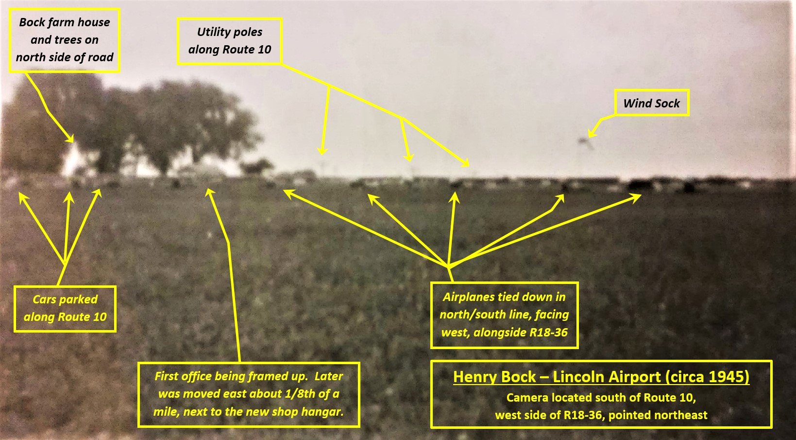
The earliest photo which has been located of Lincoln Airport was a 1945 photo (courtesy of John Bock, annotated by John Fuller).
Nancy Gehlbach reported, “The airport was a busy place.”
Lindy Fancher recalled, “There were so many people in the little office that you couldn’t turn around.”
The main activities were G.I. Bill flight training, aircraft sales & repairs, and fuel sales.
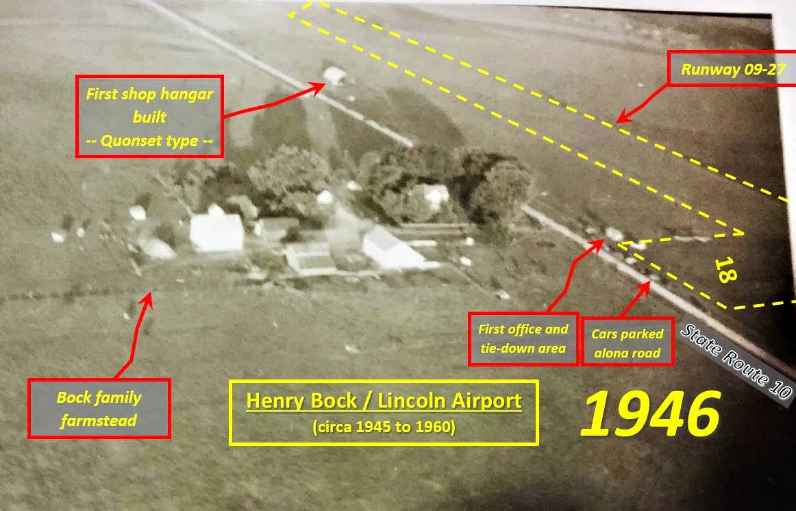
A 1946 aerial view looking southeast at Lincoln Airport (ourtesy of John Bock, annotated by John Fuller).
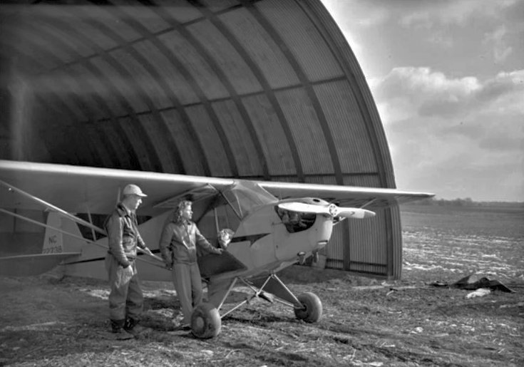
A 1946 photo (from the Bloomington Pantagraph, courtesy of John Fuller) of flight instructors Ray Suiter & Ethel Jones in front of a Piper Cub in a Quonset hut hangar at Lincoln Airport.
Ray Suiter had invested $10k in the airfield & a distributorship for Aeronca planes in 38 states.
Lincoln Airport was still not depicted on the December 1946 Chicago Sectional Chart.
John Fuller reported, “In 1946, not long after the Bock property was transformed into an airport,
the citizens of Logan County passed a referendum to plan & fund a separate new airport”, which would eventually be built to the east of the town.
Lincoln Airport was once again depicted on the June 1947 Chicago Sectional Chart,
and described as having a mere 2,000' unpaved runway.
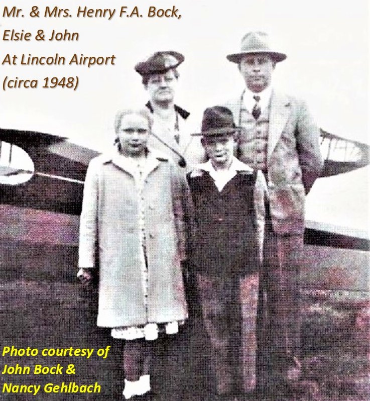
A circa 1948 photo (courtesy of John Fuller) of Henry Bock & family in front of an Aeronca at Lincoln Airport.
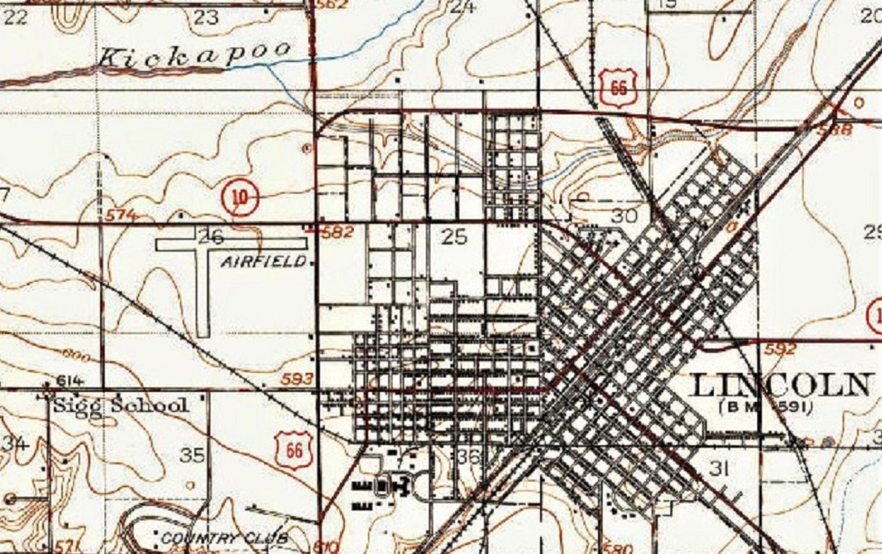
The 1949 USGS topo map (courtesy of John Fuller) depicted Lincoln Airport as 2 perpendicular runways, generically labeled “Airfield”.
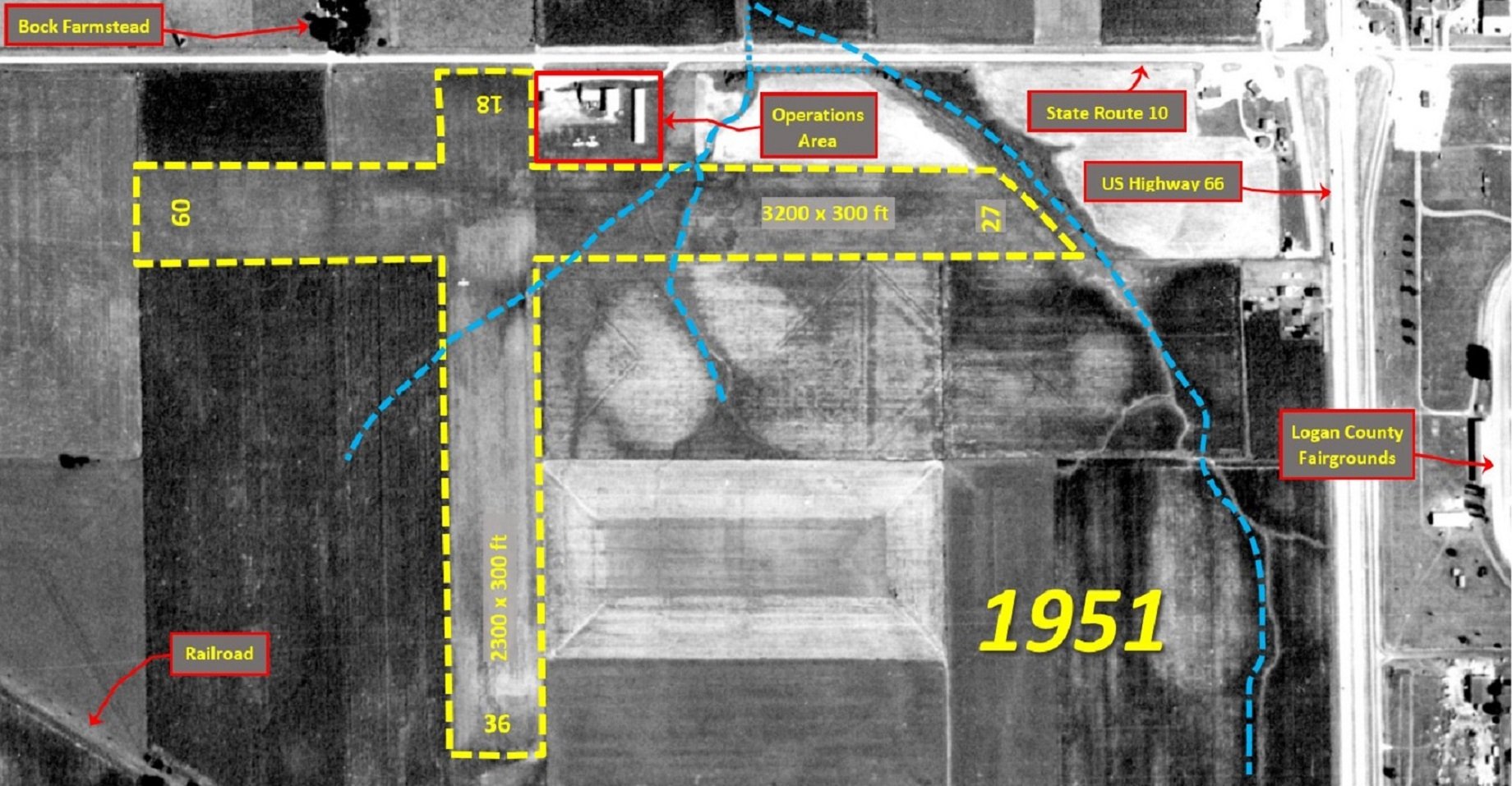
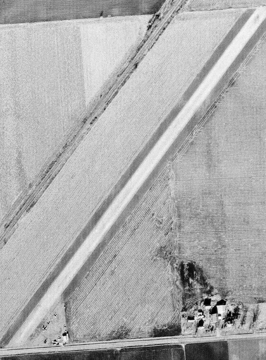
A 1951 aerial view (annotated by John Fuller) depicted Lincoln Airport as having 2 perpendicular unpaved runways, with 2 light aircraft parked near some small buildings on the northeast side.
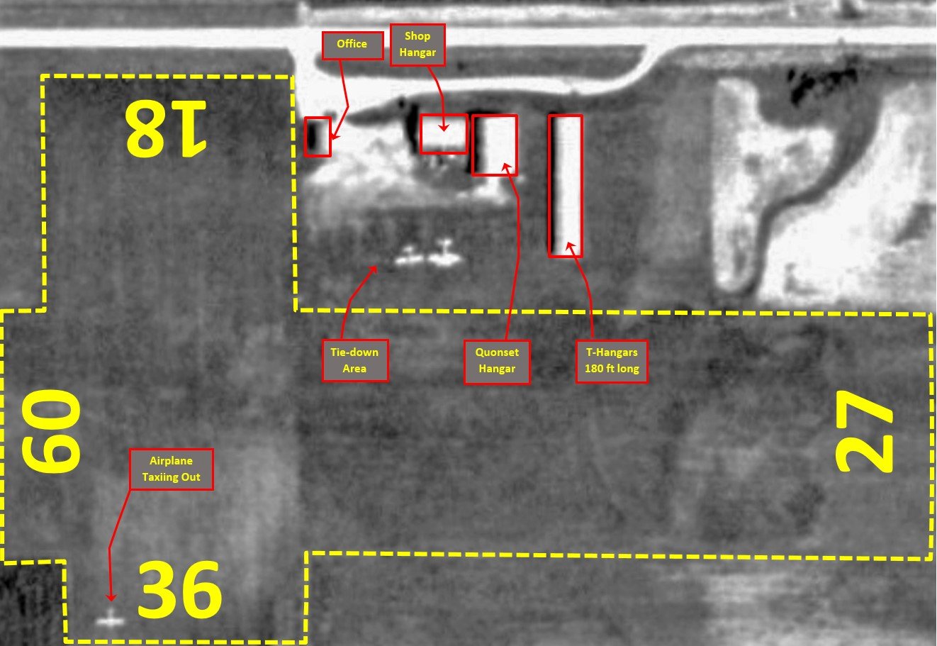
A closeup from the 1951 aerial view (annotated by John Fuller) of the Lincoln Airport operations area.
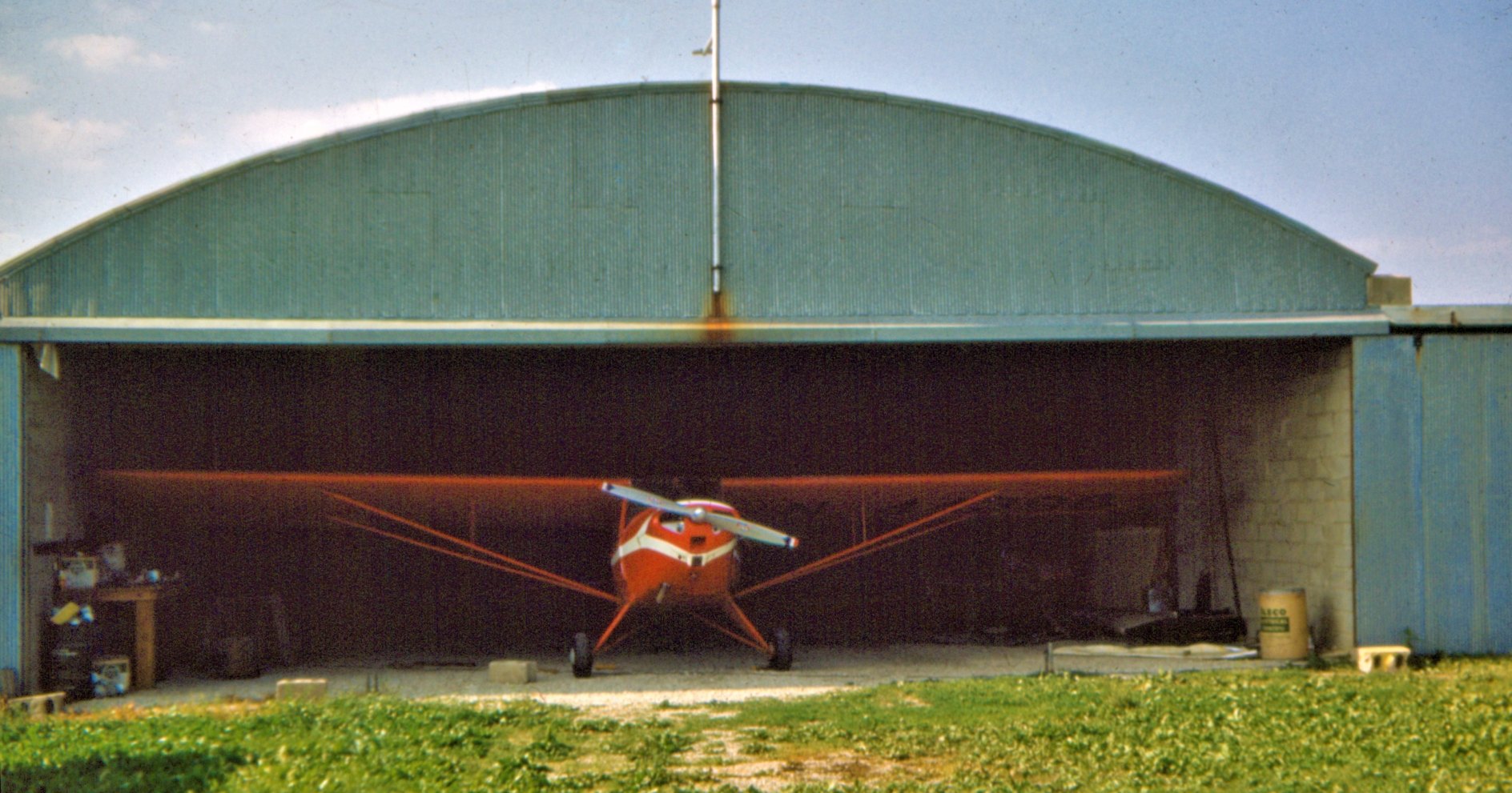
A 1955 photo (courtesy of Dick Martin) of a single-engine taildragger inside a Lincoln Airport hangar.
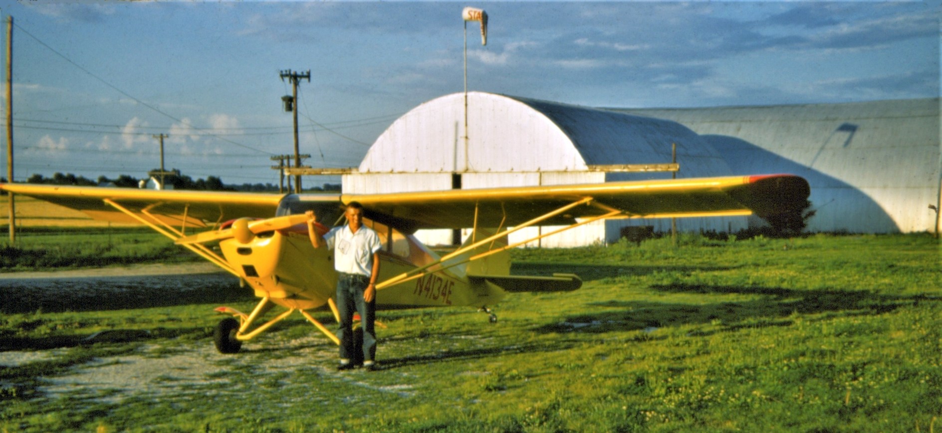
A 1955 photo (courtesy of Dick Martin) of Dick Martin & a 1947 Aeronca in front of a Lincoln Airport hangar.
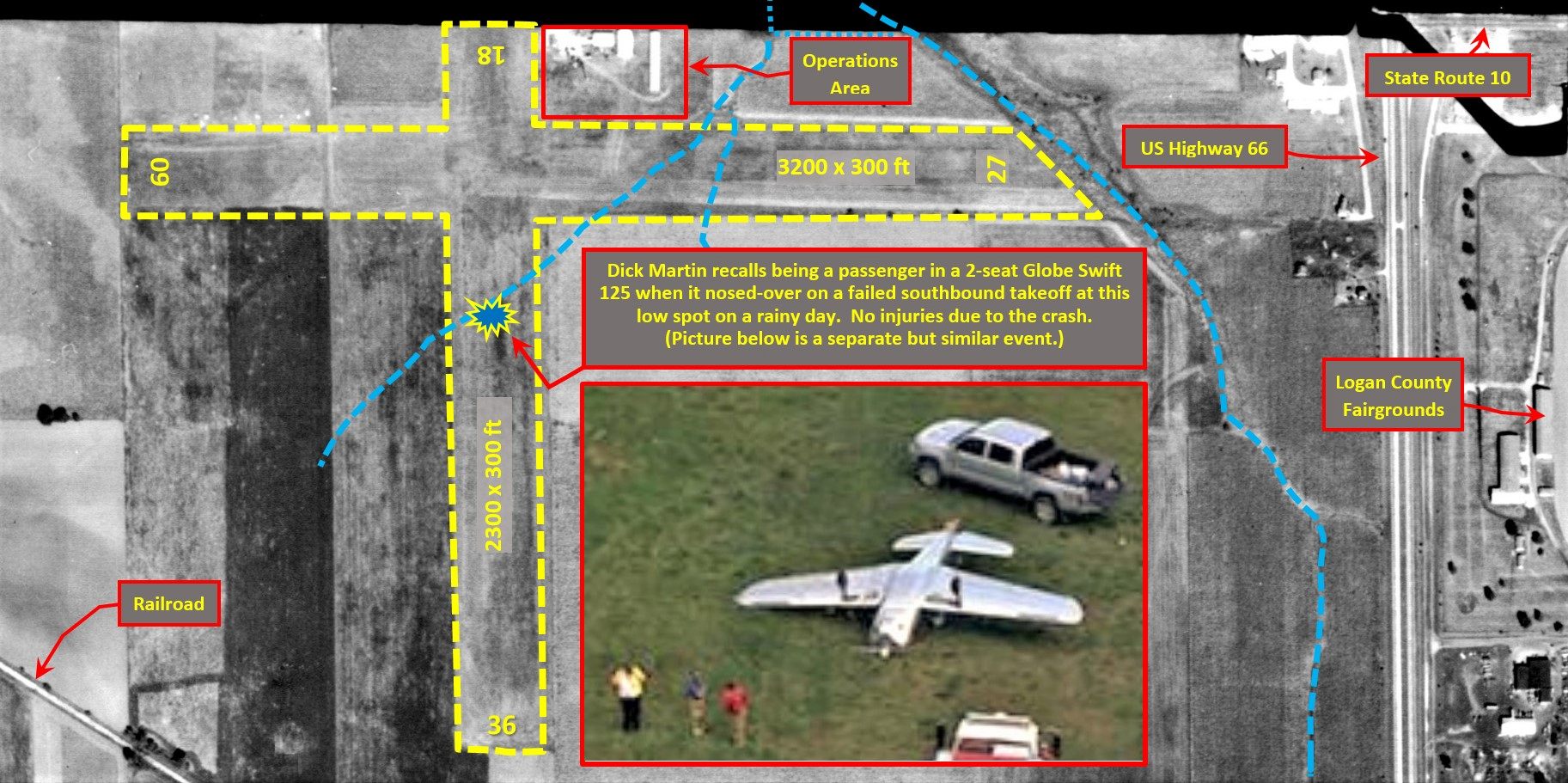
A 1957 aerial view (annotated by John Fuller) of Lincoln Airport.
The last aeronautical chart depiction which has been located of Lincoln Airport was on the January 1959 Chicago Sectional Chart.
It depicted Lincoln Airport as having a 3,100' unpaved runway.
Lincoln Airport was evidently closed (officially) at some point in 1959, as it was no longer depicted on the June 1959 Chicago Sectional Chart.
John Fuller reported, “In less than 10 years, and as aviation activity shifted to the Logan County Airport, with its hard-surface & lighted runway, the Bock airport faded out of existence.
It appears the last flight ops were around 1960, with the few buildings being leased to other businesses for uses such as auto repair & equipment storage.
A tornado in the spring of 1963 destroyed much of the remaining structures.”
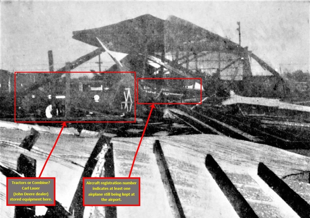
A 1963 Larry Shroyer photo (from the Lincoln Courier, annotated by John Fuller) of storm damage at Lincoln Airport.
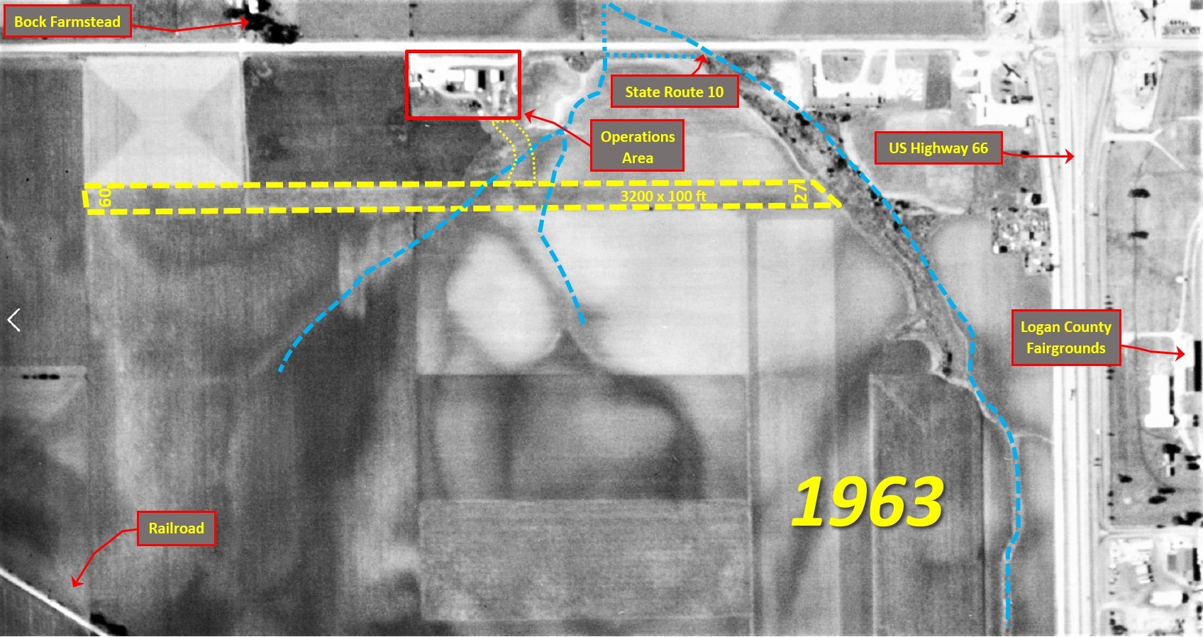
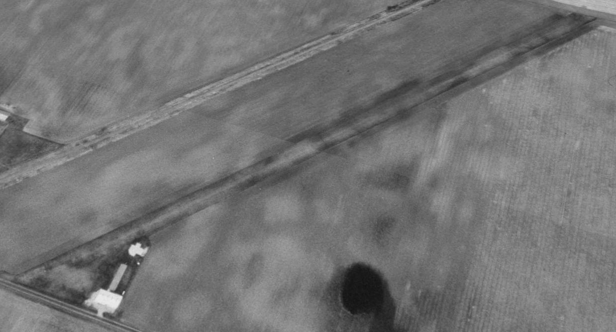
A 1963 aerial view (annotated by John Fuller) of Lincoln Airport.
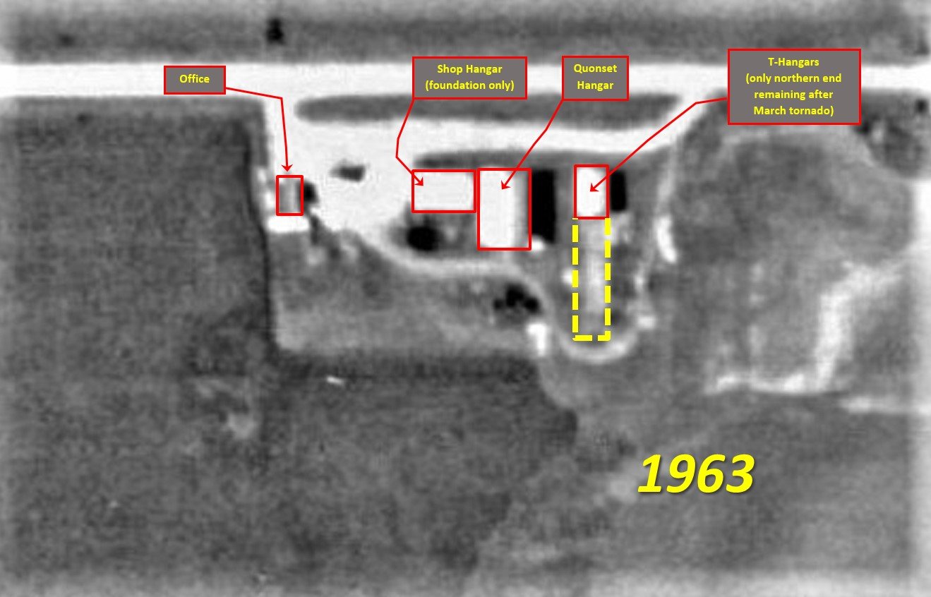
A closeup from the 1963 aerial view (annotated by John Fuller) of Lincoln Airport's operations area.
Presumably the last aircraft to land at Lincoln Airport was flown by Larry Whitbeck, who recalled:
“The plane I landed there was my first personal airplane - a forest green & Daytona Cream Stinson 108-1! I purchased that airplane in the summer of 1973.
I landed on the south end of Runway 18 because I knew the airport had been closed for years, and I did not want to get in trouble by someone reading my N-number had I been on Runway 27.
That [Stinson] had a very short takeoff roll with only the pilot on board, maybe 500-600'. All took place south of the field waterway, which was soft & grown up with taller grass.
The only building left at that time was the Quonset [hut] with old junk & farm machinery stored in it, none of which looked usable.”
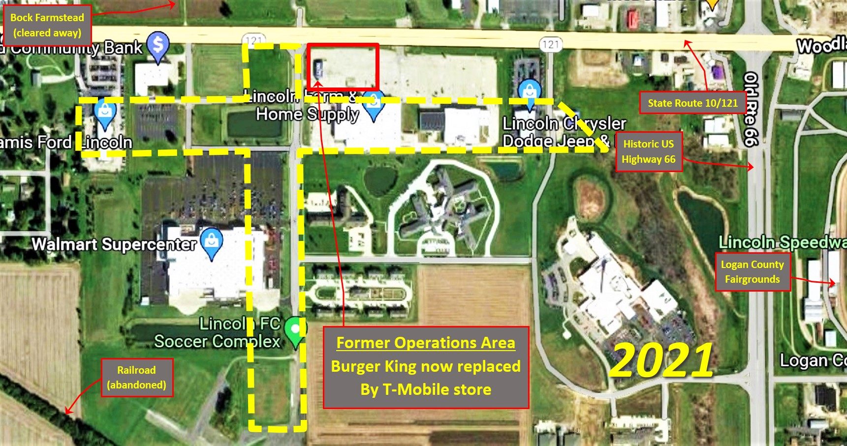
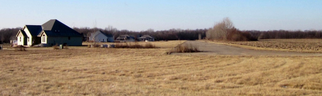
A 2021 aerial view (annotated by John Fuller) shows no trace remains of Lincoln Airport.
Thanks to John Fuller for pointing out this airfield.
____________________________________________________
41.566, -88.951 (Southwest of Chicago, IL)
Earlville Airport, as depicted on a 12/15/79 aerial view (courtesy of Mike Denja).
This small general aviation airport was evidently established at some point between 1969-78,
as it was not yet depicted on a 1969 aerial photo.
The earliest depiction which has been located of Earlville Airport was a 11/1/78 aerial view (according to Mike Denja).
The earliest depiction which is available of Earlville Airport was a 12/15/79 aerial view (courtesy of Mike Denja).
It depicted Earlville Airport as having a single grass northeast/southwest runway, with 5 light single-engine planes & a small building on the southwest side.
The earliest depiction which has been located of Earlville Airport was a 1983 aerial photo.
It depicted Earlville Airport as having a single grass northeast/southwest runway, with 2 light single-engine planes & a small building on the southeast side.
Richard Carlson recalled, “There is a good chance that my Dad & I visited Earlville Airport in a Cessna 172 in the early 1980s.
We had family in that part of the state & would drop in at small airports here & there.”
A 1998 USGS aerial view looking northwest depicted Earlville Airport as having a single grass northeast/southwest runway, with 2 small buildings on the southeast side,
but there were no aircraft visible on the field.
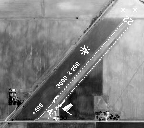
An undated aerial view from the 2004 IL Airport Guide (courtesy of Richard Carlson)
depicted Earlville Airport as having a 3,000' unpaved Runway 4/22, with a few small buildings on the southeast side.
The Fixed Base Operator was R&R Flight Service, and the manager Lyle Younglove.
According to its FAA Airport/Facility Directory data,
Earlville Airport had a single 3,400' turf Runway 4/22, was owned by John Weidner, was managed by Lyle Younglove, and had 5 based aircraft.
As of 12/31/04, Earlville Airport had an average of 39 takeoffs or landings per week.
The last listing which has been located showing Earlville Airport still in operation was in the 2008 Airport/Facility Directory (courtesy of Richard Carlson).
The last photo which has been located showing an aircraft at Earlville Airport was a 2010 aerial view looking northwest.
It showed 1 light single-engine plane parked near the foundations on the south side.
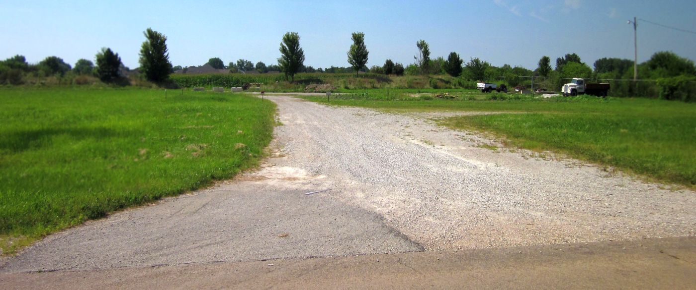
Earlville Airport was evidently closed at some point between 2010-11, as a 2011 aerial view showed the runway had been plowed over,
and it was no longer listed in the 2012 Airport/Facility Directory (according to Richard Carlson).
A 2015 aerial view looking northwest showed Earlville Airport's former runway was no longer evident, with the ground having been returned to agriculture.
The foundation of 2 small buildings remained on the south side.
Thanks to Richard Carlson for pointing out this airfield.
____________________________________________________
40.963, -90.384 (Southwest of Chicago, IL)
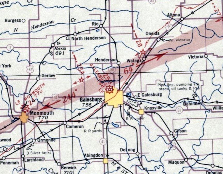
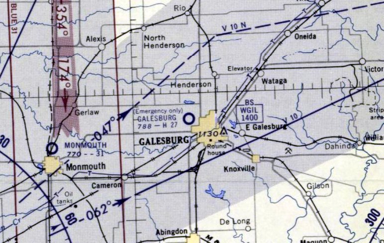
Galesburg Airport, as depicted on the September 1934 Des Moines Sectional Chart.
The date of construction of Galesburg's original airport has not been determined.
The earliest depiction which has been located of Galesburg Airport was on the September 1934 Des Moines Sectional Chart.
It depicted Galesburg as a commercial/municipal airport, located adjacent to the northwest side of the town,
with Commerce Department Airway Beacon 25B on the field.
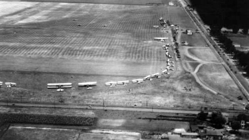
A circa 1930s aerial view looking north at Galesburg Airport (courtesy of Tim Toal) showed a gathering of biplanes, presumably military.
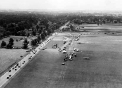
A circa 1930s aerial view looking south at Galesburg Airport (courtesy of Tim Toal) showed a gathering of biplanes, presumably military.
The earliest dated photo which has been located of Galesburg Airport was a 7/1/40 aerial photo (courtesy of Tim Toal).
It depicted Galesburg as having 2 paved runways & 2 grass runways.
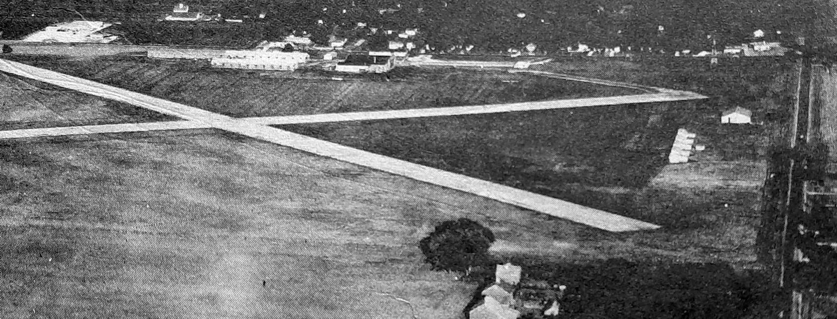
A circa 1940s aerial view looking east at Galesburg Airport (courtesy of Tim Toal) showed 2 paved runways & hangars along the east & south sides.
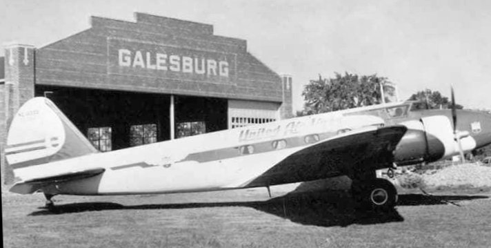
A circa 1940s photo (courtesy of Tim Toal) depicted a United Airlines Boeing 247 airliner in front of the Galesburg hangar.
A circa 1940s photo (courtesy of Tim Toal) of a single-engine taildragger in front of the Galesburg hangar.
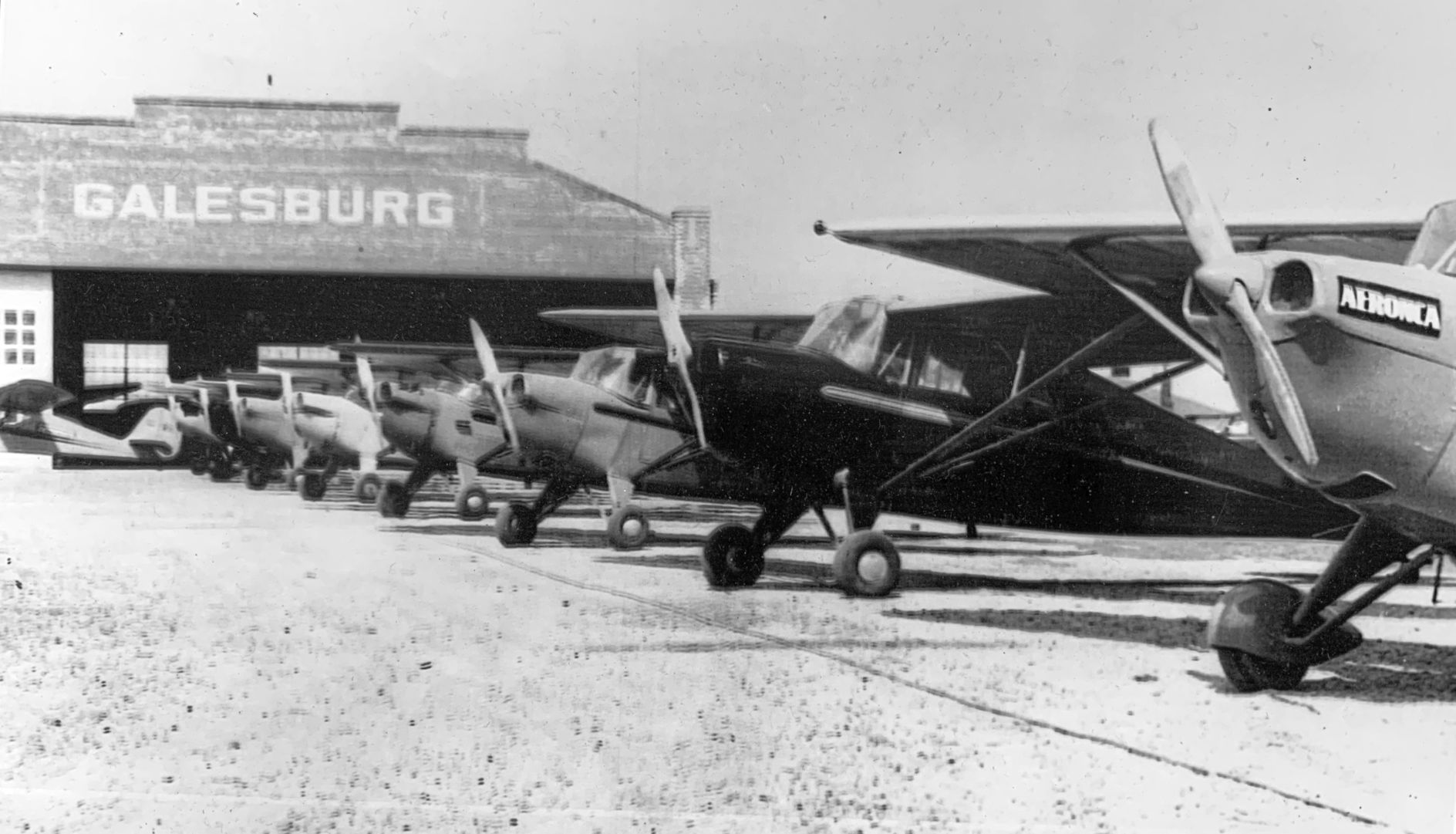
A circa 1940s photo (courtesy of Tim Toal) of a row of Aeroncas in front of the Galesburg hangar.
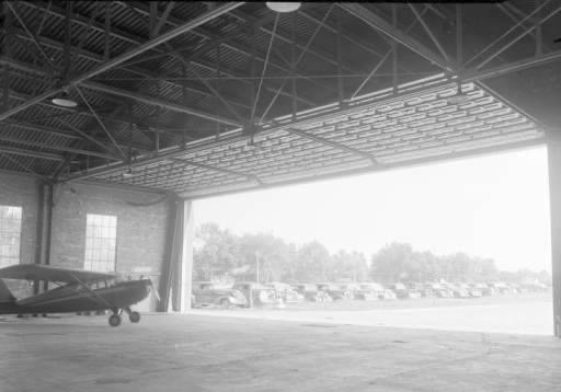
A circa 1940s photo (courtesy of Tim Toal) of a single-engine taildragger inside the Galesburg hangar.
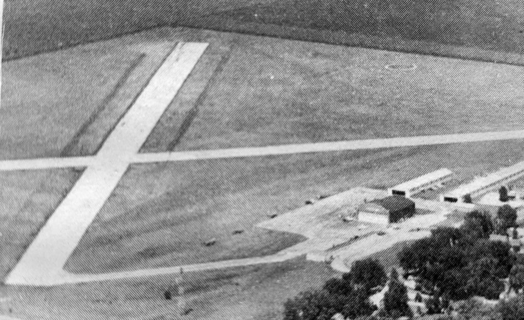
A circa 1940s aerial view looking northwest at Galesburg Airport (courtesy of Tim Toal) showed 2 paved runways & hangars along the east side.
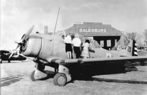
A circa 1940s photo (courtesy of Tim Toal) of a North American trainer in front of the Galesburg hangar.
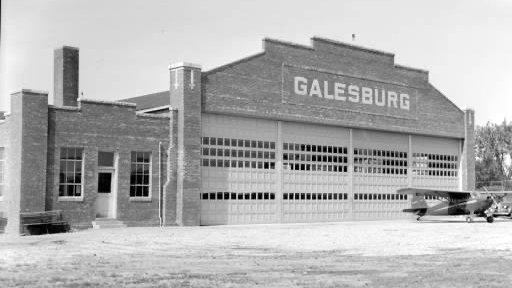
A circa 1950s photo looking north from Fremont Street at the original Galesburg Airport (courtesy of Tim Toal)
depicted 4 single-engine taildragger monoplanes & a biplane parked near a hangar marked “Galesburg”.
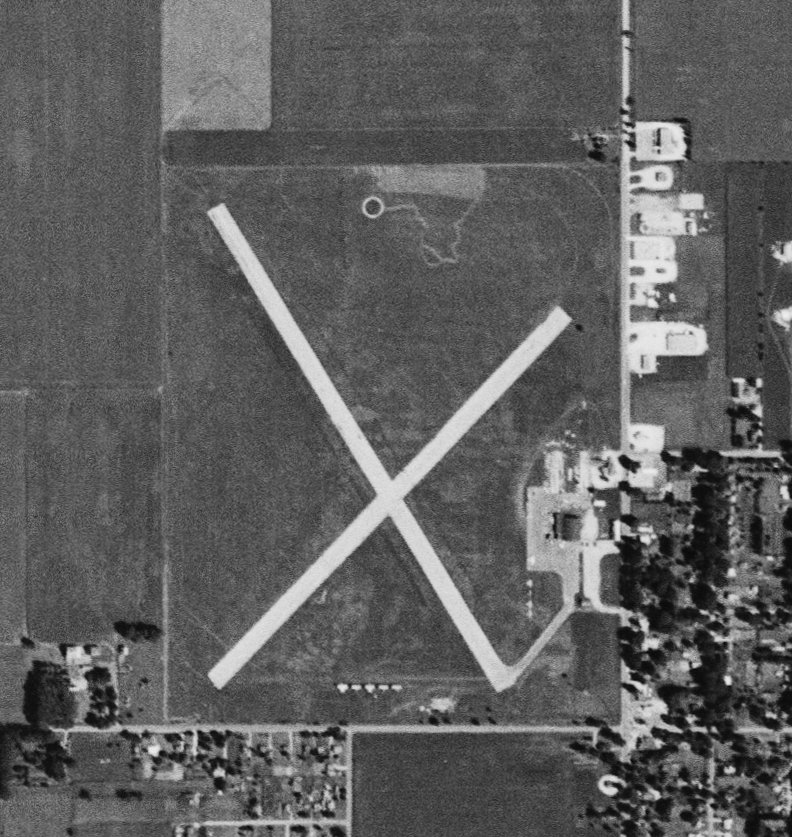
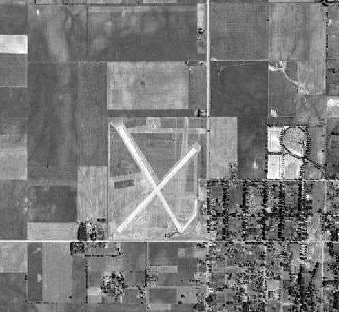
The last dated photo which has been located of Galesburg Airport was an 8/21/56 USGS aerial view.
It depicted Galesburg as having 2 paved runways, with a hangar along the east side, 5 T-hangars on the south side, and several light aircraft parked on the southeast side.
The last depiction which has been located of the original Galesburg Airport was on the December 1956 Des Moines Sectional Chart.
It depicted Galesburg as having a 2,700' paved runway, but also included the note “Emergency only”,
which presumably foreshadowed the airport's replacement within the next year.
Tim Toal reported, “Our airport on North Henderson moved to its current location in about 1957.
The airport moved from close-in to further out west to make room for a new high school & other development.”
The original Galesburg Airport was no longer depicted on the June 1957 Des Moines Sectional Chart,
which instead depicted the replacement Galesburg Airport, west of the town.
Tim Toal reported, “The new Galesburg Senior High School opened in the fall of 1959 at the west southwest side of the old airport site.”
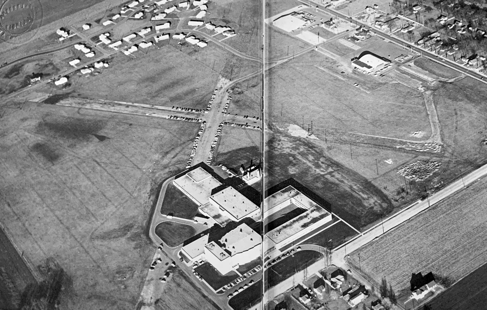
An undated aerial view (courtesy of Tim Toal) from the 1959 Galesburg High School Yearbook looking northeast at the Galesburg Airport site, with the high school built over the southern portion,
but the majority of the 2 runways remained, along with the hangar on the east side.
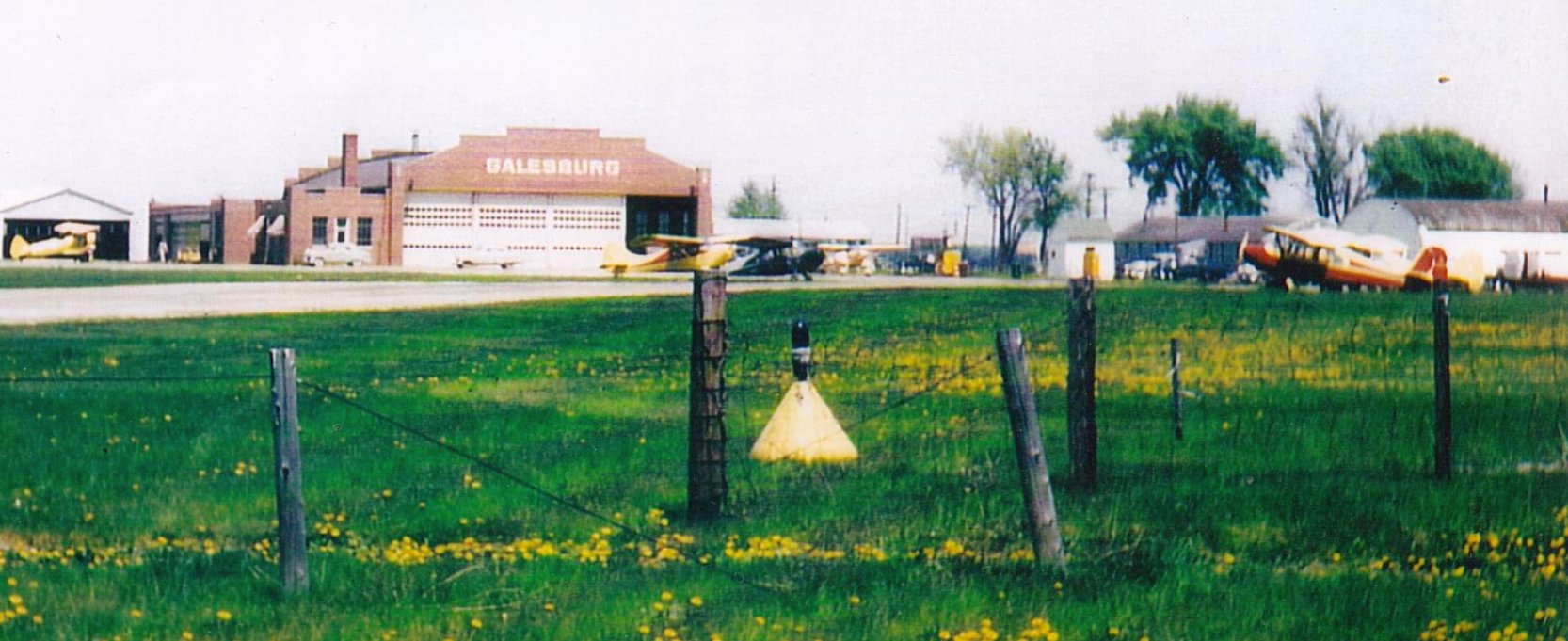
Tim Toal reported, “The hangar building was an store in the 1960s & 1970s.
They took the hangar doors off & converted the building when the airport closed.”
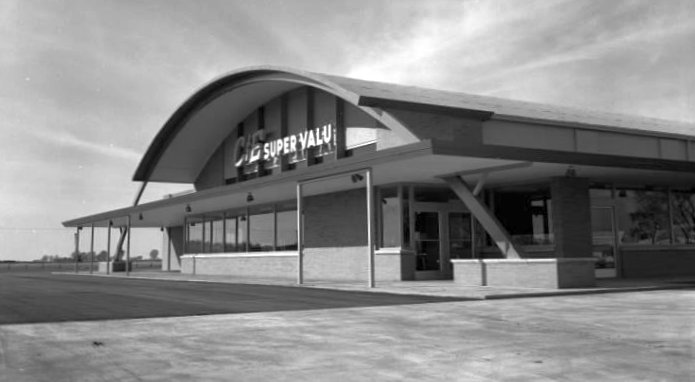
A circa 1960s photo of the C/E Super Value hardware store which reused the former Galesburg Airport hangar (courtesy of Tim Toal).
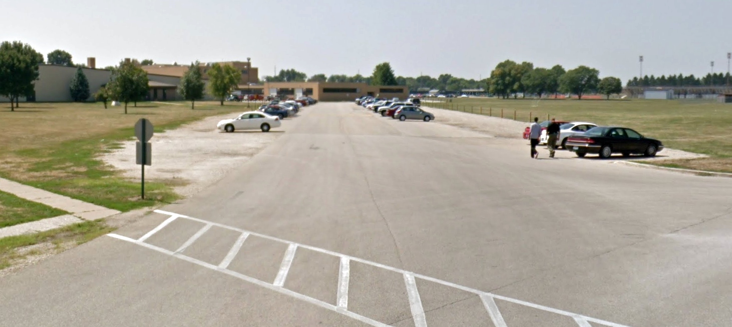
An August 2011 photo looking southwest along a former Galesburg runway, reused as Silver Streak Boulevard.
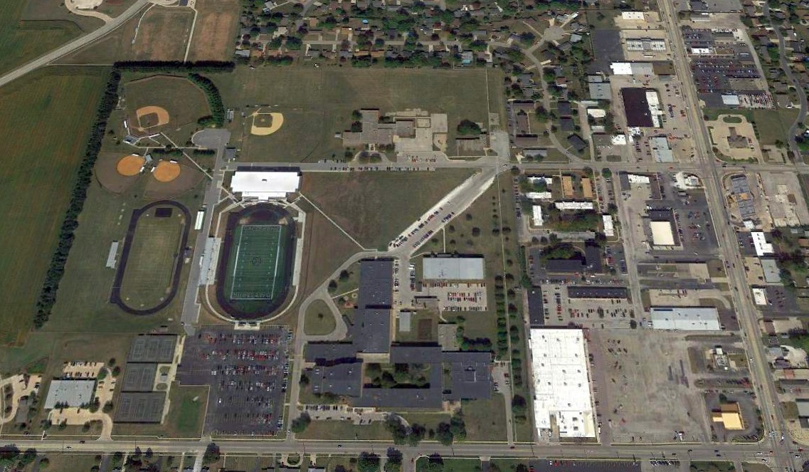
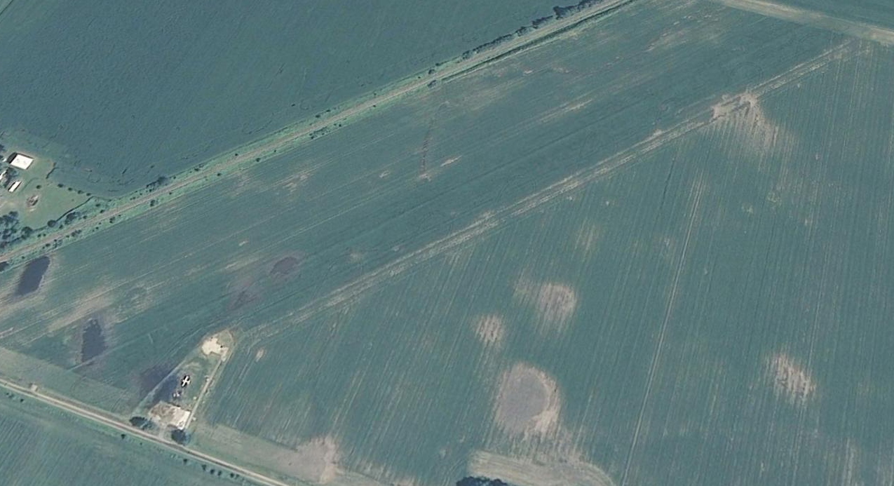
A 2017 aerial view looking north at the site of the original Galesburg Airport showed Galesburg High School occupying the western portion of the site,
but the former hangar remained on the northeast side of the site.
A remnant of the southwest end of a runway is in the center of the photo, on the north side of the school, named Silver Streak Boulevard.
Tim Toal reported in 2021, “The hangar building has a liquor store & a home furnishings store in it; located at 1400 North Henderson Street.”
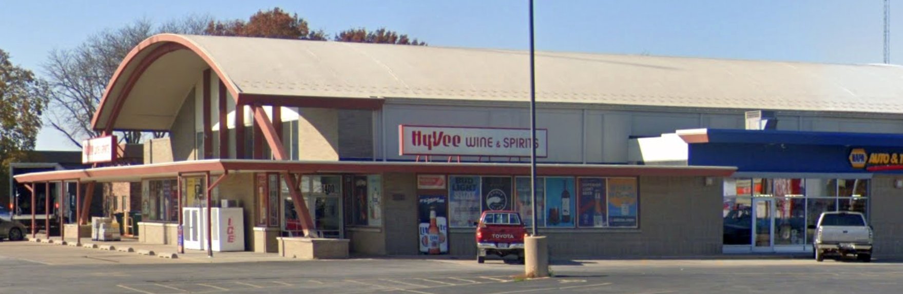
A November 2022 photo looking west at the retail stores which reuse the former Galesburg Airport hangar.
Thanks to Tim Toal for pointing out this airfield.
____________________________________________________
41.213, -87.985 (Southwest of Chicago, IL)
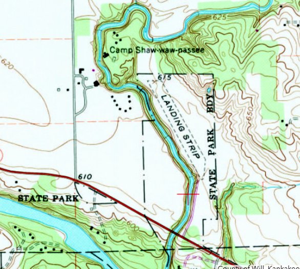
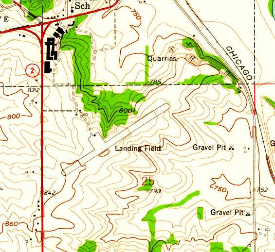
Kankakee River State Park Airfield, as depicted on the 1978 USGS topo map.
Not much is known about this small airfield, including its name.
It was evidently constructed at some point between 1952-61,
as it was not yet depicted on a 1952 aerial photo or the 1959 USGS topo map.
No airfield was depicted at this location on Chicago Sectional Charts from 1951/55/60/65/70.
The earliest photo which has been located of this airfield was a 1961 aerial photo, which depicted a single unpaved northwest/southeast runway.
David Swan recalled “The grass landing strip with a wind sock that was at the Kankakee River State Park in the 1960s & 1970s, for small planes.
We had a Cessna 210 & my father landed there regularly.”
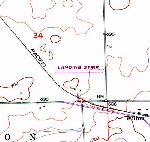
The 1978 USGS topo map depicted a single unpaved northwest/southeast runway, generically labeled as “Landing Strip”, within the boundaries of the Kankakee River State Park.
Camp Shaw-waw-passee was depicted adjacent to the northwest.
Gregg Maryniak recalled, “Kankakee River State Park Airfield... I flew to the airfield in a Cessna 172 in August 1982.
The field was nicely mowed & my wife & I & our guests were impressed with the tranquility of the park.
We purposely arrived with a light fuel load.”
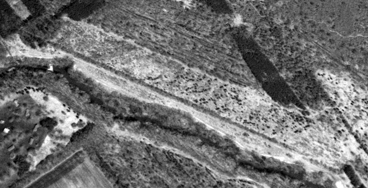
The earliest photo which is available of the Kankakee River State Park Airfield was a 1994 USGS aerial view looking northeast.
It depicted the overgrown remains of a single unpaved northwest/southeast runway.
David Swan reported of the airfield, “The Superintendent of the Kankakee State Park said it was already closed in 1996 when he started there.”
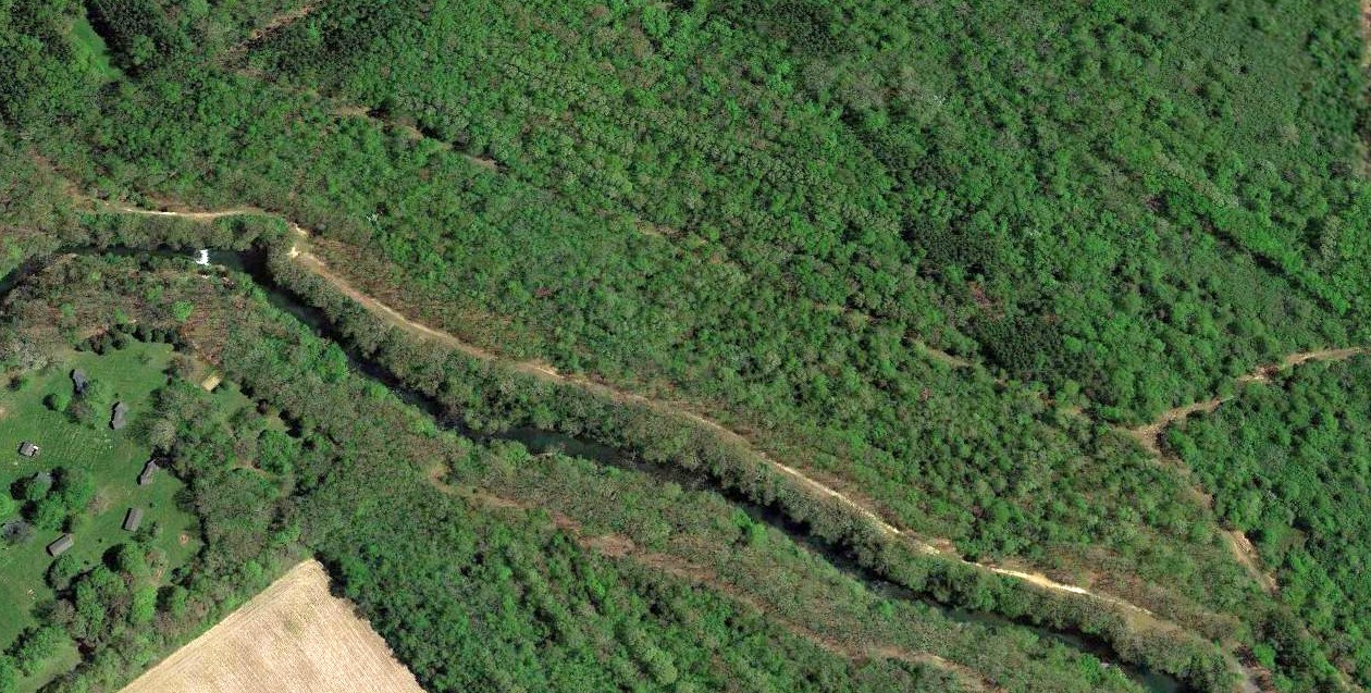
A 2017 aerial view looking northeast at the site of the Kankakee River State Park Airfield showed the overgrown remains of the runway barely recognizable.
Thanks to David Swan for pointing out this airfield.
____________________________________________________
Clarence C. Johnson Field, Manhattan, IL
41.384, -87.945 (Southwest of Chicago, IL)
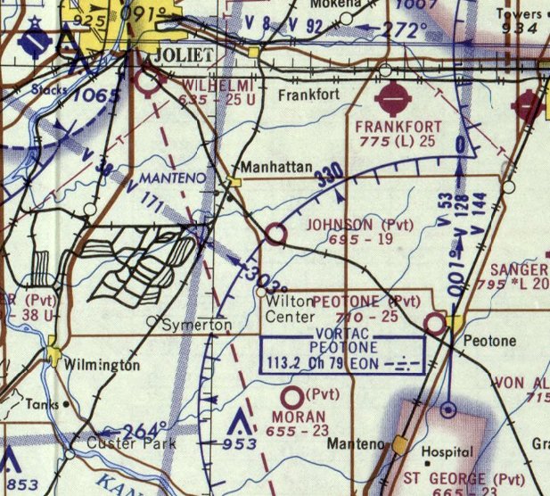
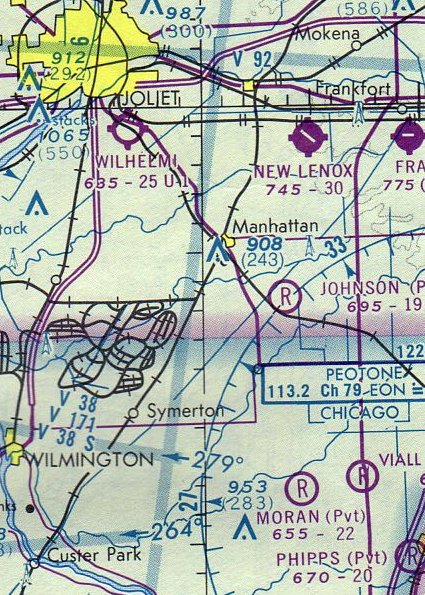
Johnson Field, as depicted on the December 1967 Chicago Sectional Chart.
The date of establishment of this small grassroots airfield southwest of Chicago has not been determined.
A 1952 aerial photo showed what may have been an early unpaved east/west runway, to the north of a farmhouse & other small buildings.
A 1961 aerial photo showed a more distinct unpaved east/west runway, slightly to the north of the previous possible runway.
Johnson Field was not yet depicted on the 1955 USGS topo map nor on the May 1967 Chicago Sectional Chart.
The earliest aeronautical chart depiction which has been located of Johnson Field was on the December 1967 Chicago Sectional Chart.
It depicted Johnson as a private airfield having a mere 1,900' unpaved runway.
The May 1968 Chicago Sectional Chart (courtesy of Larry Nussbaumer) described Clarence C. Johnson Field as having a 1,900' unpaved east/west runway.
Larry Nussbaumer recalled, “When I started my flight training in 1969, I flew from a small field just southeast of Manhattan, IL.
Clarence C. Johnson Field was a grass field set in the middle of a cornfield.
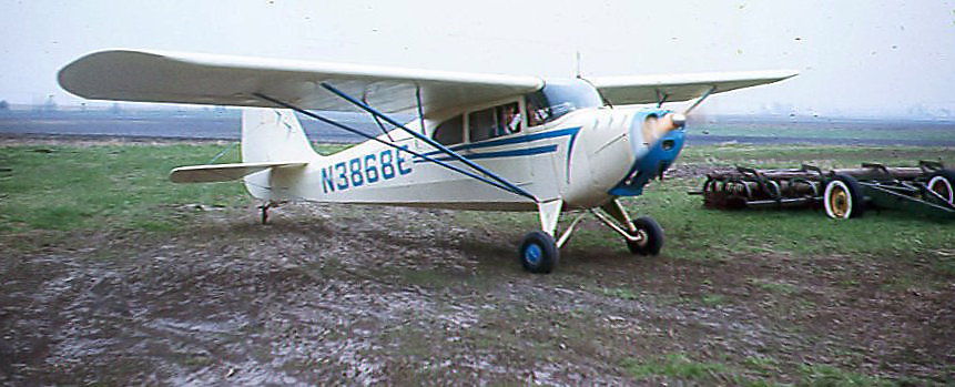
Mr. Johnson kept his TriPacer in a barn on the field, and my Civil Air Patrol squadron commander at the time, Jim Lalumendre, kept his 1946 Aeronca Chief there, as well.”
A 1969 photo by Larry Nussbaumer of Jim Lalumendre & Mary Ann Nussbaumer taxiing in Jim's 1946 Aeronca Chief at Johnson Field.
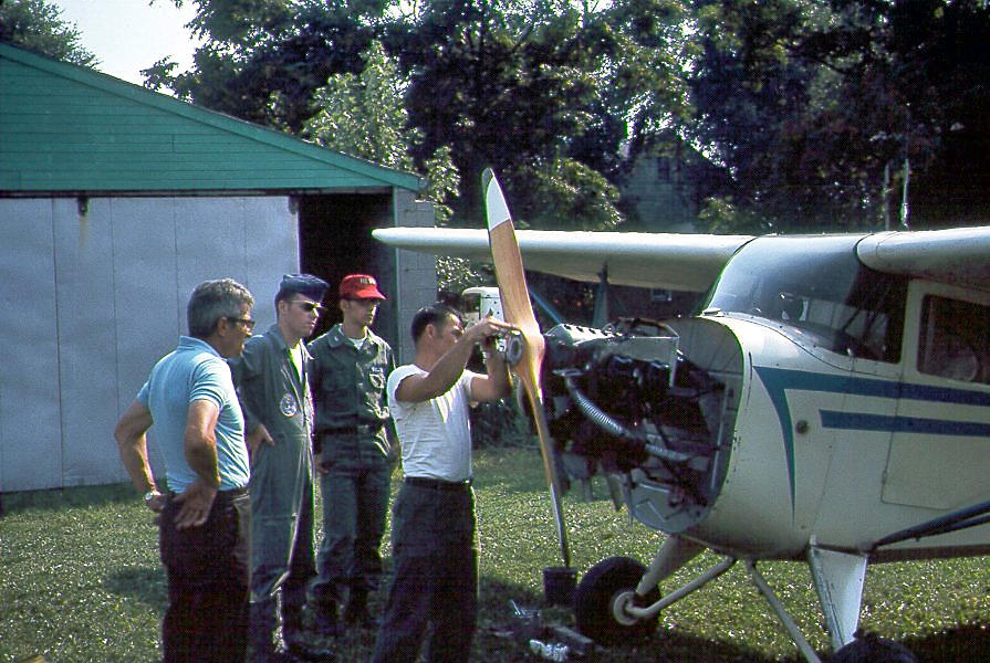
A 1969 photo by Larry Nussbaumer of Jim Lalumendre working on his 1946 Aeronca Chief at Johnson Field.
Larry Nussbaumer observed, “The one in the flight suit (with the overseas cap) is Dan Sullivan, an older cadet (or maybe he'd just turned senior member).”
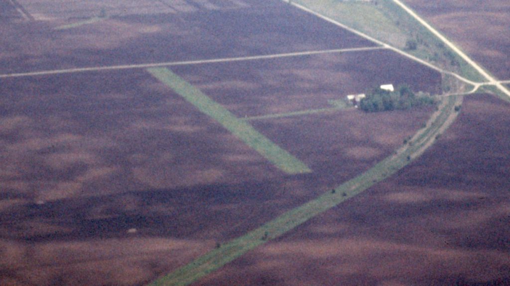
A circa 1960s aerial view by Larry Nussbaumer depicted Johnson Field as having a single east/west grass runway with several buildings to the south.
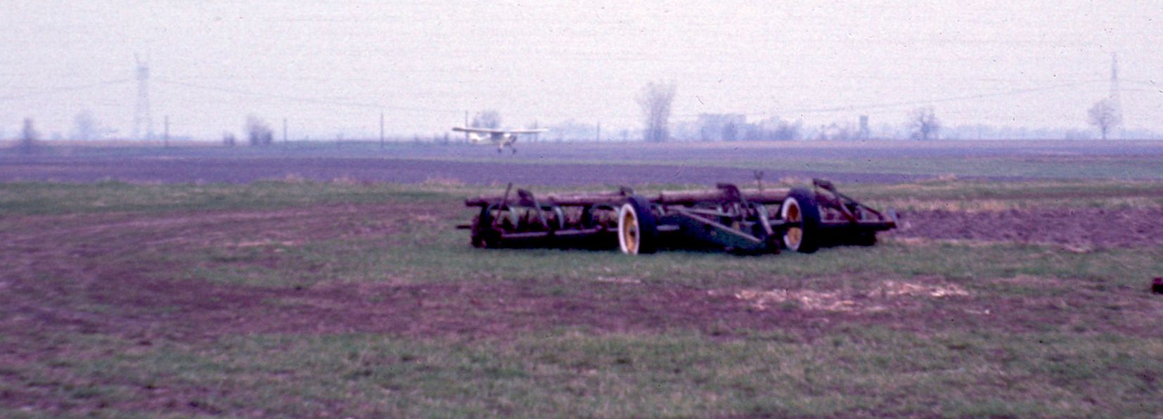
A circa 1960s photo by Larry Nussbaumer of Chief N3868E landing on Johnson Field, taken from the parking area.
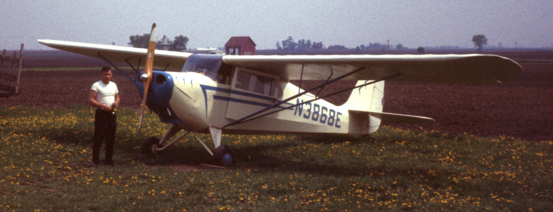
A circa 1960s photo by Larry Nussbaumer of Jim Lalumendre with his Aeronca Chief at Johnson Field.
The 1970 IL Airport Directory (according Larry Nussbaumer) described Clarence C. Johnson Field as having a 1,900' unpaved east/west runway.
The 1973 USGS topo map depicted Johnson Field as an unpaved east/west runway, genericaly labeled as “Landing Strip”.
A 1973 aerial photo showed Johnson Field's unpaved east/west runway was somewhat less distinct than in the 1961 aerial view,
but there was 1 light single-engine aircraft parked to the south, near the farm house & buildings.
A 1974 aerial photo showed Johnson Field in the same configuration, but there were no aircraft visible on the field.
The last aeronautical chart depiction which has been located of Johnson Field was on the May 1975 Chicago Sectional Chart,
which depicted Johnson as a private airfield having a 1,900' unpaved runway.
The 1980 USGS topo map depicted Johnson Field in the same configuration as on the 1973 topo map, but with the name “Johnson Landing Strip”.
Johnson Field was evidently closed (for reasons unknown) at some point between 1975-88,
as it was no longer depicted on the 1988 Chicago Sectional Chart (according Larry Nussbaumer).
The 1990 USGS topo map continued to depict “Johnson Landing Strip”.
Amazingly a 2017 aerial view looking northwest continued to show the former Johnson Field unpaved east/west runway as very recognizable,
even though the airfield has evidently been closed for approximately 30 years.
Thanks to Larry Nussbaumer for pointing out this airfield.
____________________________________________________
Sycamore Airport, Sycamore, IL
41.983, -88.662 (West of Chicago, IL)
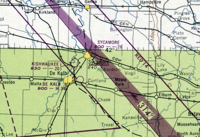
Sycamore Airport, as depicted on the December 1948 Chicago Sectional Chart.
Photo of the airport is not available.
This general aviation airport west of Chicago was evidently established at some point between 1946-48
(like hundreds of other small U.S. airports, in the post-WW2 general aviation boom),
as it was not yet depicted on the December 1946 Chicago Sectional Chart (courtesy of Ron Plante).
The earliest depiction which has been located of Sycamore Airport was on the December 1948 Chicago Sectional Chart,
which depicted Sycamore Airport as having a 2,600' unpaved runway.
The only photo which has been located of Sycamore Airport was a 1953 aerial view.
It depicted Sycamore Airport as having 4 unpaved runways, with a few small buildings & 1 light single-engine plane on the northeast side.
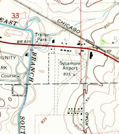
The 1968 USGS topo map depicted Sycamore Airport as having 4 unpaved runways, with a few small buildings on the north side.
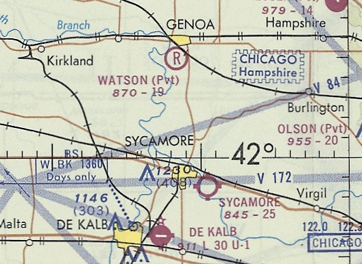
The last aeronautical chart depiction which has been located of Sycamore Airport was on the October 1970 Chicago Sectional Chart,
which depicted Sycamore Airport as having a 2,500' unpaved runway.
According to David Johnson, Sycamore Airport “closed around 1970.”
The reason for the airport's closure has not been determined.
Sycamore Airport was no longer depicted on the November 1974 Chicago Sectional Chart (courtesy of Ron Plante).
A 1975 aerial photo showed baseball fields covering the site of the Sycamore Airport runways.
Two former hangars remained on the northeast side, the only remnants of the airport.
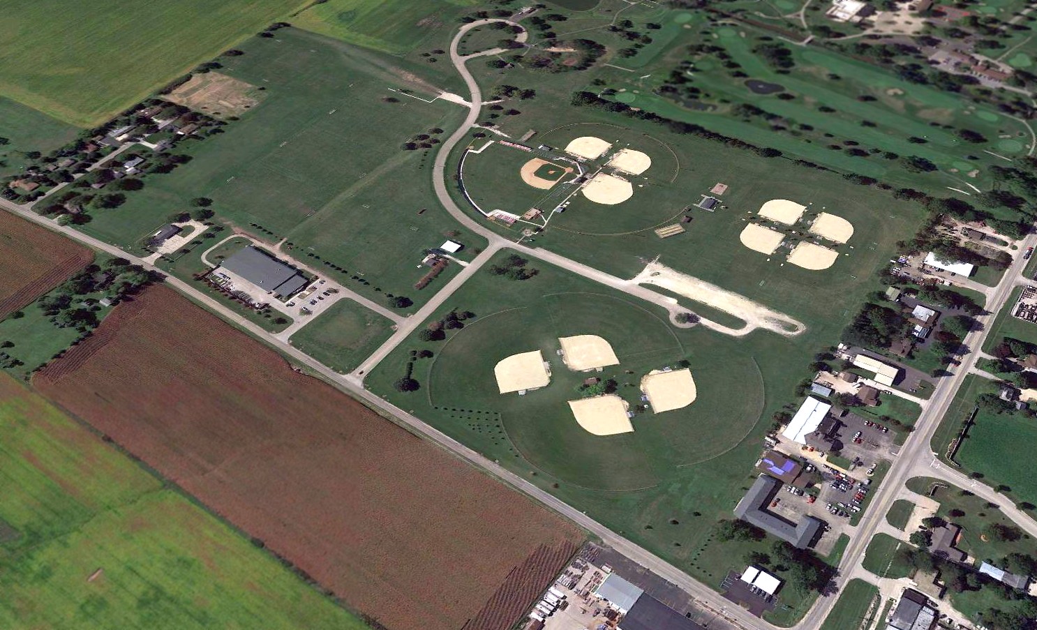
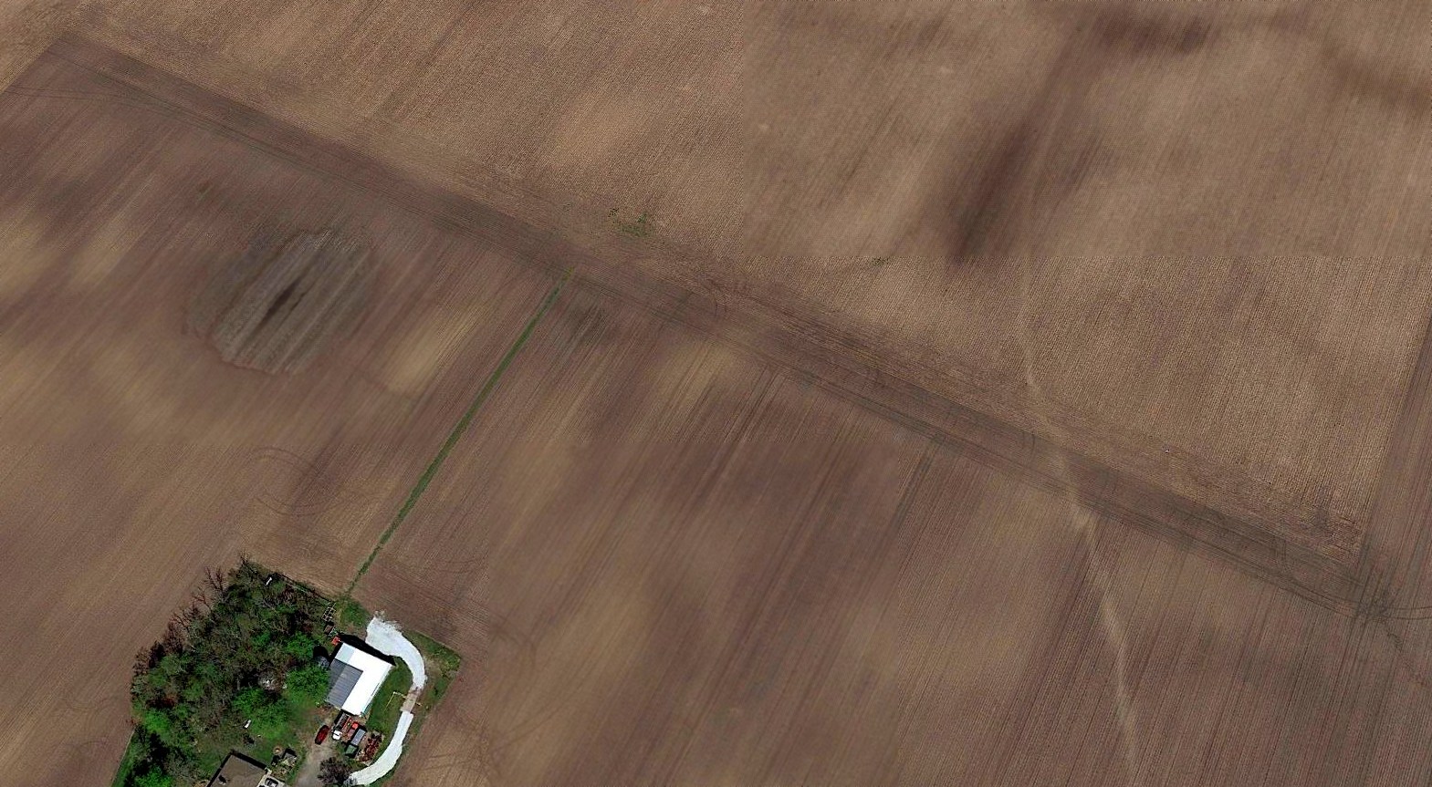
A 2015 aerial view looking southwest at the site of Sycamore Airport covered by baseball fields.
A few buildings at the northeast corner (bottom-right of photo) are former hangars.
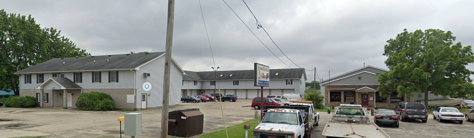
A 2019 photo looking south at former hangars along the north side of the Sycamore Airport site, though completely unrecognizable as former hangars.
The site of Sycamore Airport is located southwest of the intersection of Route 64 & Airport Road, appropriately enough.
Thanks to David Johnson for pointing out this airfield.
____________________________________________________
South Beloit Airport / Beloit Airways Airport, South Beloit, IL
42.476, -89.036 (Northwest of Chicago, IL)
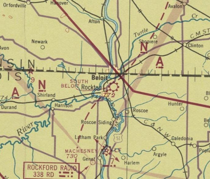
South Beloit Airport, as depicted on the June 1942 Milwaukee Sectional Chart.
According to Kent Van Galder, “The South Beloit Airport was opened in the mid-1930s.”
However, no airport in Beloit was depicted on 1935/37/39 Milwaukee Sectional Charts.
According to Kent Van Galder, “My Dad ran the airport in South Beloit [starting in] 1940.
The airport was there [in 1940] and had a few hangars on it, but didn't have a operator, and dad took on that role.
Russell Van Galder was owner, operator, mechanic, instructor, charter pilot, etc., as were many operators trying to make a living running a small airport.
Dad was a CFI, A&E, AI, and a Designated Flight Examiner.
Dad did charter flying, aircraft repair, and flight instruction, along with farming between the runways.
At one time we had 20-25 airplanes on the airport. Every thing from Cubs & Stearmans to a Cessna Bobcat.
Dad instructed students on the WWII GI Bill.”
South Beloit Airport was not yet depicted on the September 1941 Milwaukee Sectional Chart.
The earliest depiction which has been located of South Beloit Airport was on the June 1942 Milwaukee Sectional Chart.
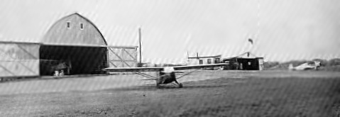
The earliest photo which has been located of South Beloit Airport was a circa 1945 photo
of 3 planes & 2 hangars from the book “Taming the Blue” by Marge Van Galder (courtesy of Kent Van Galder).
Kent Van Galder observed, “The little shack behind the left wing was the office.”
A 1946 aerial view (courtesy of Lee Corbin) depicted South Beloit Airport as having 4 unpaved runways,
with a few small buildings & several light planes on the northwest side.
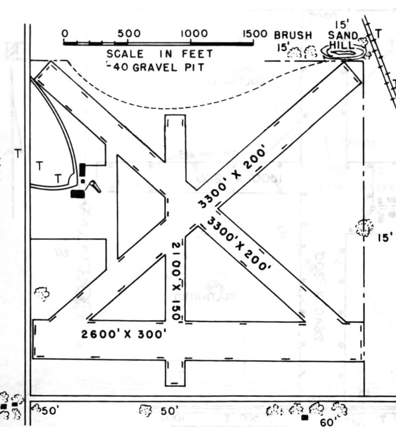
The 1953 IL Airport Directory (courtesy of Lee Corbin) depicted South Beloit Airport as having 4 unpaved runways, with the longest being the 3,300' northwest/southeast & northeast/southwest strips.
Three small buildings were depicted on the west side.
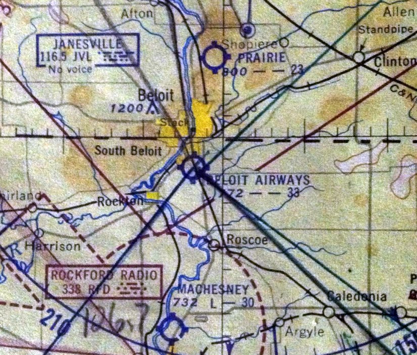
The May 1953 Milwaukee Sectional Chart (courtesy of Kent Van Galder) depicted “Beloit Airways” Airport as having a 3,300' unpaved runway.
According to Kent Van Galder, “Dad instructed students on the Korean War GI Bill. I soloed from this airport in 1955.”
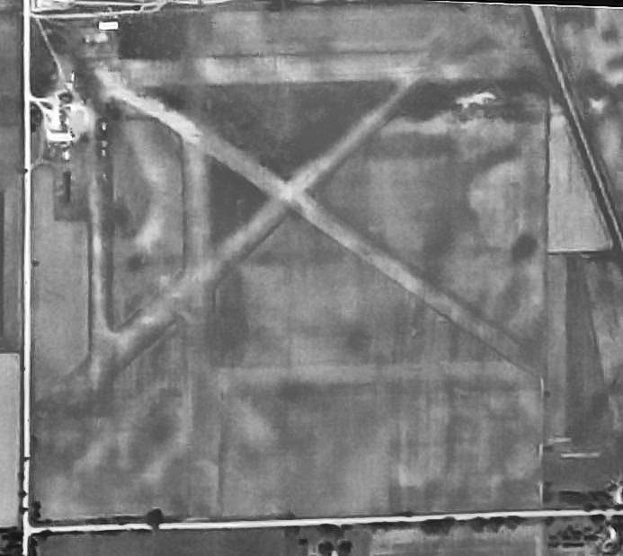
An April 1956 USGS aerial view (courtesy of Lee Corbin) depicted South Beloit Airport shortly before its demise.
The eastern portion had been taken over for storage, and the gravel pit had expanded over the northern portion of the airport.
But the remainder of the runways & several buildings still remained, and at least 7 light aircraft were still visible on the northwest corner.
According to Kent Van Galder, “We rented the airport from a gravel company & as time progressed, the pit got bigger & bigger, and you can guess what happened to the airport.
My Dad ran this airport to 1958 at which time it was closed down.”
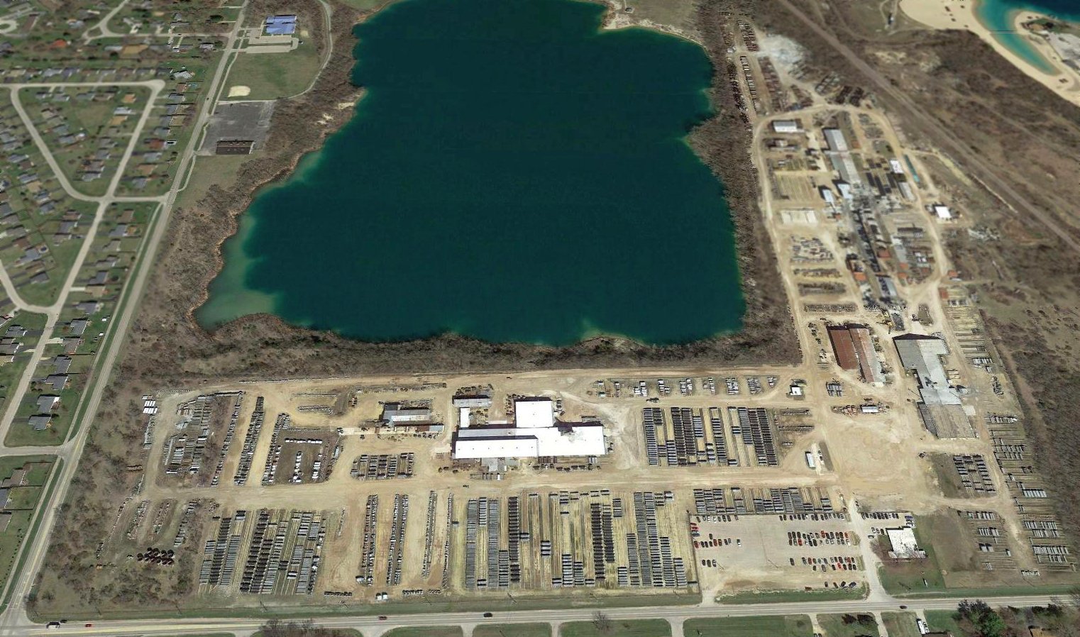
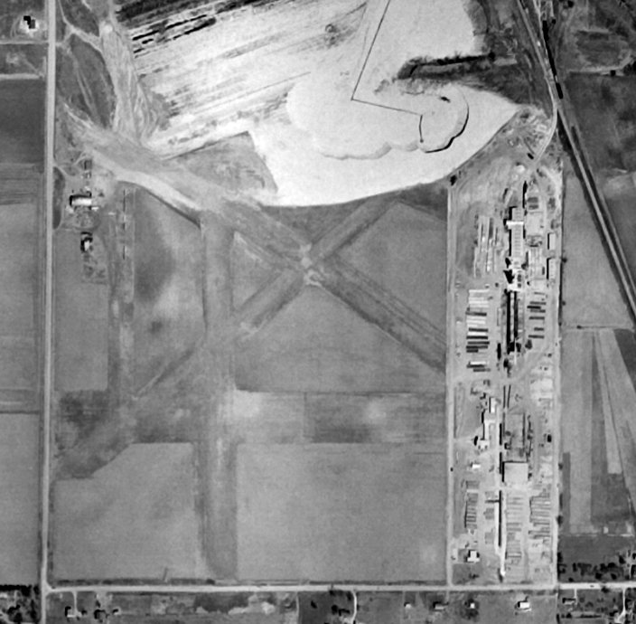
A 2017 aerial view looking north showed no trace remaining of south Beloit Airport, with most of the property having been covered by the flooded gravel pit.
____________________________________________________
Piper Airport (C41), Princeton, IL
41.37, -89.43 (West of Chicago, IL)
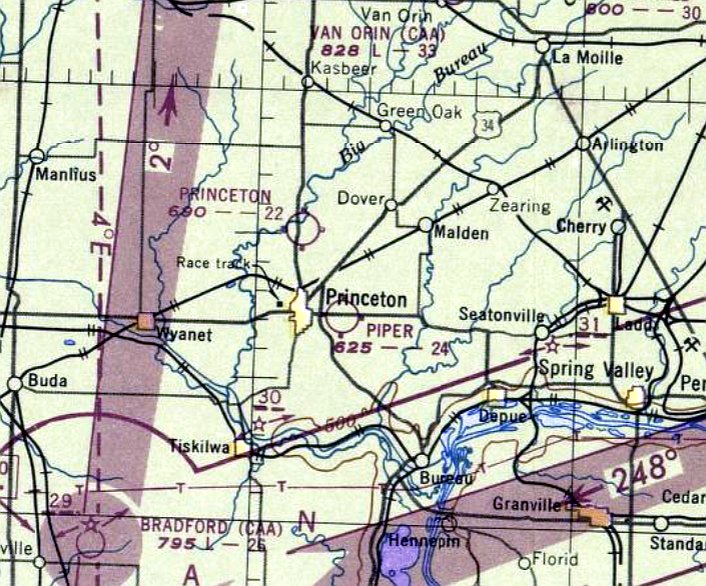
Piper Airport, as depicted on the December 1947 Chicago Sectional Chart.
According to the video “Piper Airport Princeton” (courtesy of Jonathan Westerling),
“After the War [WW2] a farmer, Roger Piper, built an airport next to his farm, a mile east of town.
The May Brothers, Marvin, Melvin, and Walter, rented the airport in 1946.
They had 2 planes for training & rental plus Roger Piper's Cabin Waco for passenger flights.”
Piper Airport was not yet depicted on the June 1947 Chicago Sectional Chart.
The earliest depiction which has been located of Piper Airport was on the December 1947 Chicago Sectional Chart.
It depicted Piper as a commercial/municipal airport having a 2,400' unpaved runway.
According to the video “Piper Airport Princeton” (courtesy of Jonathan Westerling),
“In 1951 Melvin May left & became a civilian flight instructor for the Army.
Elmo Salsman was the Chief Flight Instructor for the Mays from 1951-83.”
The 1953 IL Airport Directory (courtesy of Lee Corbin) depicted Piper Airport as having 2 unpaved runways,
and 3 small buildings on the northwest side.
A 1953 Sectional Chart (courtesy of Jonathan Westerling) depicted Piper Airport as having a 2,400' unpaved runway.
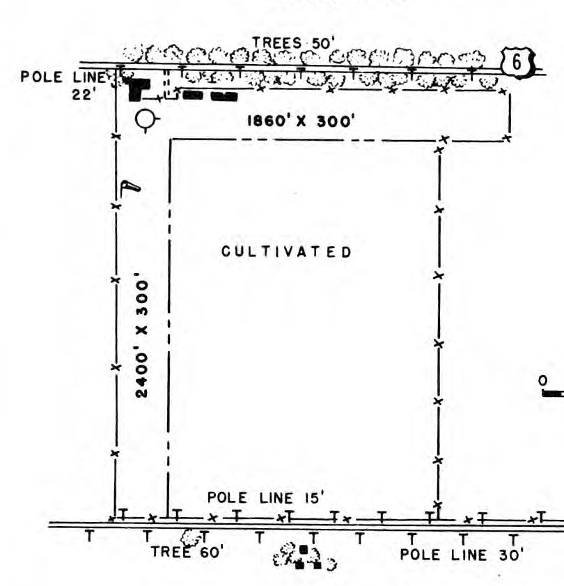
The earliest photo which has been located of Piper Airport was an undated aerial view from the 1962 IL Airport Directory (courtesy of Jonathan Westerling).
It depicted Piper Airport as having 2 turf runways, measuring 2,500' north/south & 1,850' east/west.
Several hangars were depicted on the northwest side. The manager was listed as Marvin May.
According to the video “Piper Airport Princeton” (courtesy of Jonathan Westerling),
“Rental rates in 1964: Aeronca 7AC: $7/hr wet, Cessna 172 $12/hr wet.”
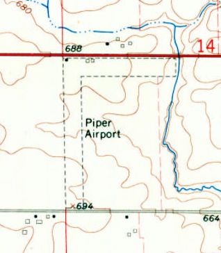
The 1966 USGS topo map depicted Piper Airport as having 2 unpaved runways, with 2 small buildings on the northwest side.
A 1953 Sectional Chart (courtesy of Jonathan Westerling) depicted Piper Airport as having a 2,500' unpaved runway.
According to the video “Piper Airport Princeton” (courtesy of Jonathan Westerling),
“As of 1974, 1,000 students had soled from there. Many went on to aviation careers.”
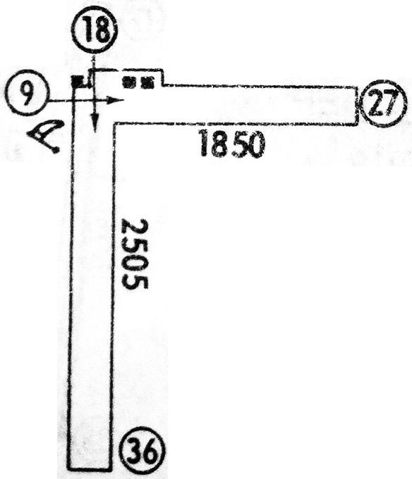
A 1979 airport directory (courtesy of Jonathan Westerling) depicted Piper Airport as having 2 unpaved runways: 2,505' Runway 18/36 & 1,850' Runway 9/27.
Two small buildings were depicted on the northwest side.
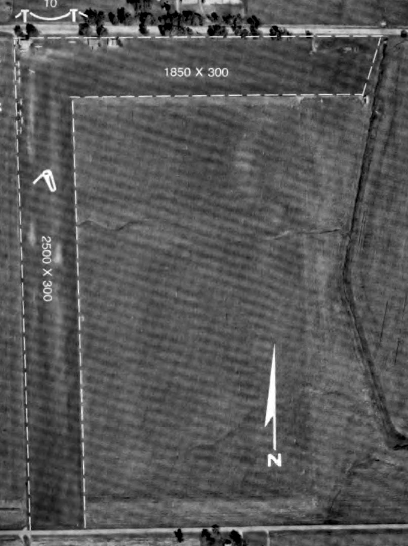
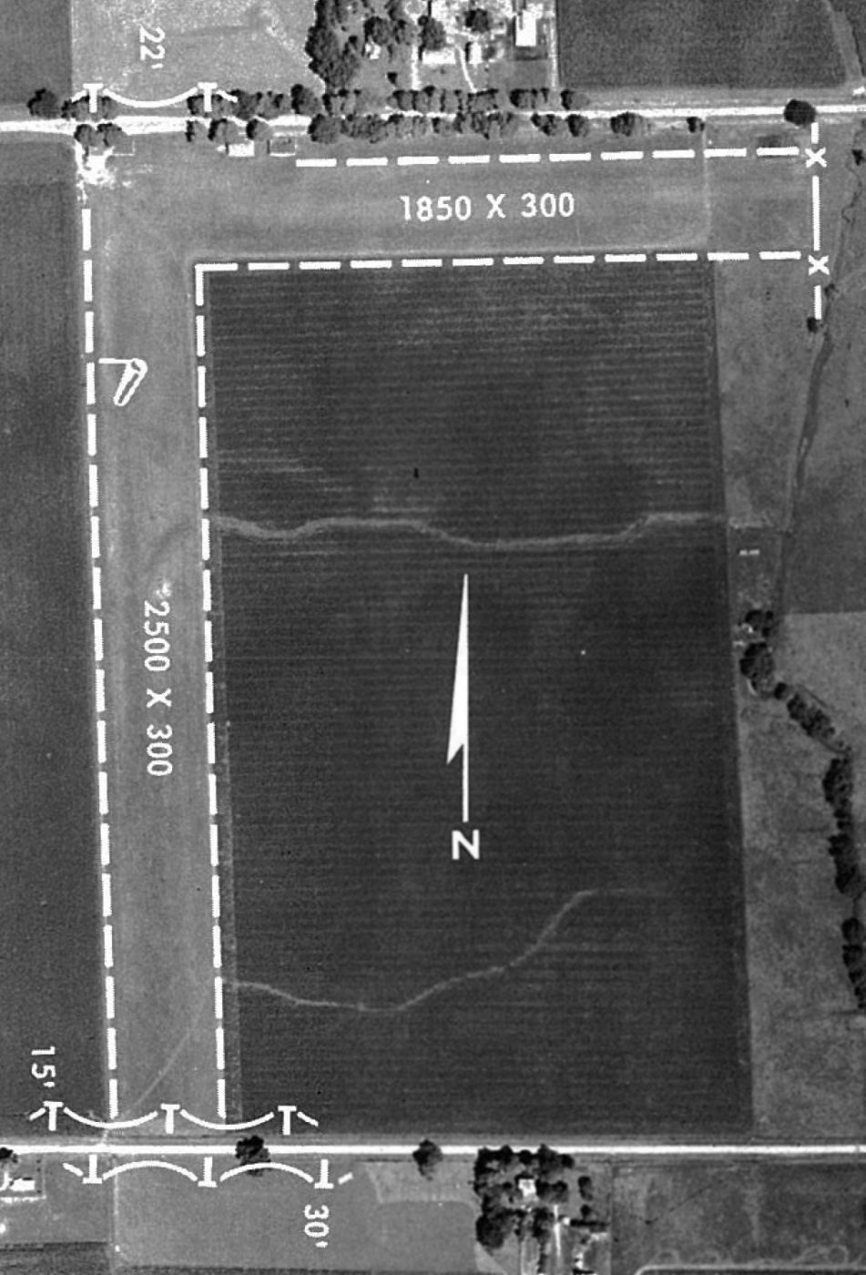
The last photo which has been located of Piper Airport was an undated aerial view from the 1980 IL Airport Directory (from the University of IL, courtesy of Daniel McGill).
It depicted Piper as having 2 grass runways, measuring 2,500' north/south & 1,850' east/west.
It appeared quite popular for a little airport, with 10 light single-engine aircraft seen on the northwest side near some small buildings.
According to the video “Piper Airport Princeton” (courtesy of Jonathan Westerling),
“In 1983 Marvin retired & sold the operation to Marty Mart & Paul Swanson.
When they went out of business, the airport became private.”
The 1989 AOPA Airports USA Directory (courtesy of Jonathan Westerling) described Piper Airport
as a private-use airfield having a single 2,500' turf Runway 18/36.
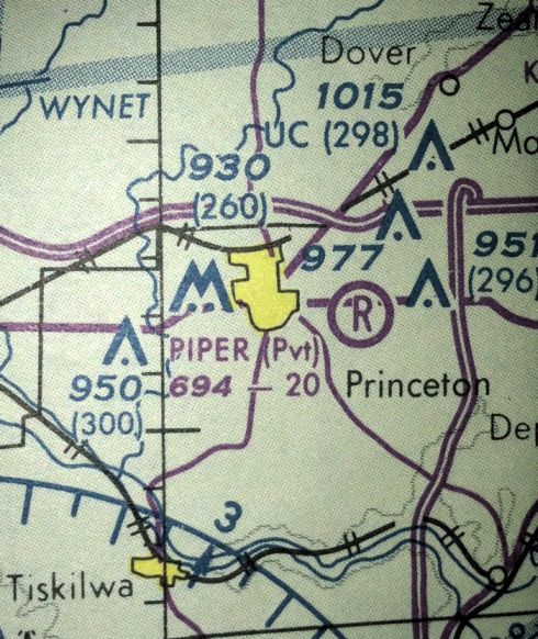
The last aeronautical chart depiction which has been located of Piper Airport was on the 1994 Sectional Chart (courtesy of Jonathan Westerling).
It depicted Piper Airport as a private airfield, having a 2,000' unpaved runway.
According to the video “Piper Airport Princeton” (courtesy of Jonathan Westerling), “The airport... was razed in 1997.”
A 1998 aerial view showed the Piper Airport runways had been plowed over & reused for farming.
A 2015 aerial view showed no trace of Piper Airport, with the runways & airport buildings having been erased from the landscape.
The site of Piper Airport is located southeast of the intersection of Route 6 & South 9th Street.
Thanks to Jonathan Westerling for pointing out this airfield.
____________________________________________________
Starved Rock Airpark, Utica, IL
41.325, -89 (West of Chicago, IL)
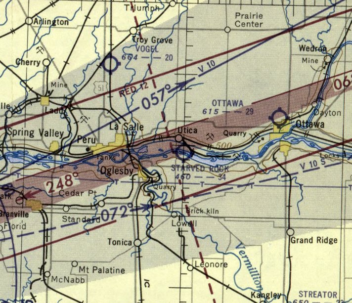
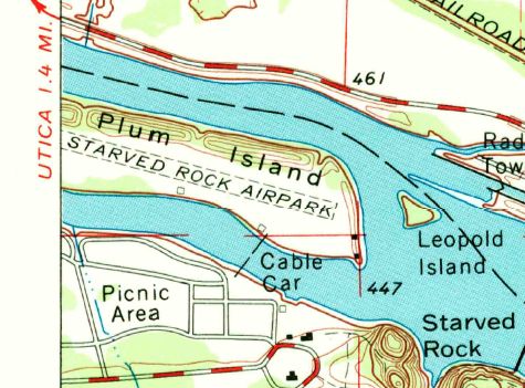
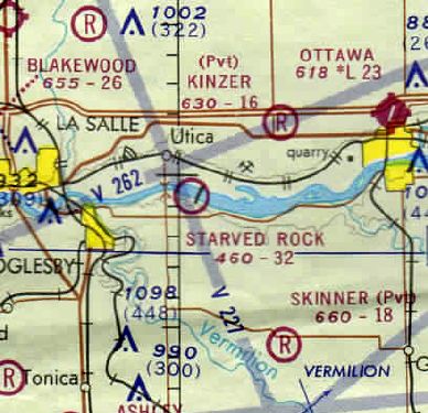
Starved Rock Airpark, as depicted on the December 1952 Chicago Sectional Chart.
According to Bill Pagett, “This airport is both odd & unique - it was located on an island [Plum Island] in the Illinois River
and visitors to the Starved Rock State Park that flew in, had to take a cable car from the landing field across the river to the state park.”
In 1950 Starved Rock Air Park was issued a state charter to operate landing strip / air park on Plum Island opposite Starved Rock State Park.
Starved Rock Airpark was not yet depicted on the November 1950 Chicago Sectional Chart.
The earliest depiction which has been located of Starved Rock Airpark was on the December 1952 Chicago Sectional Chart,
which depicted it as having a 3,400' unpaved runway.
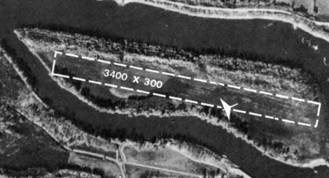
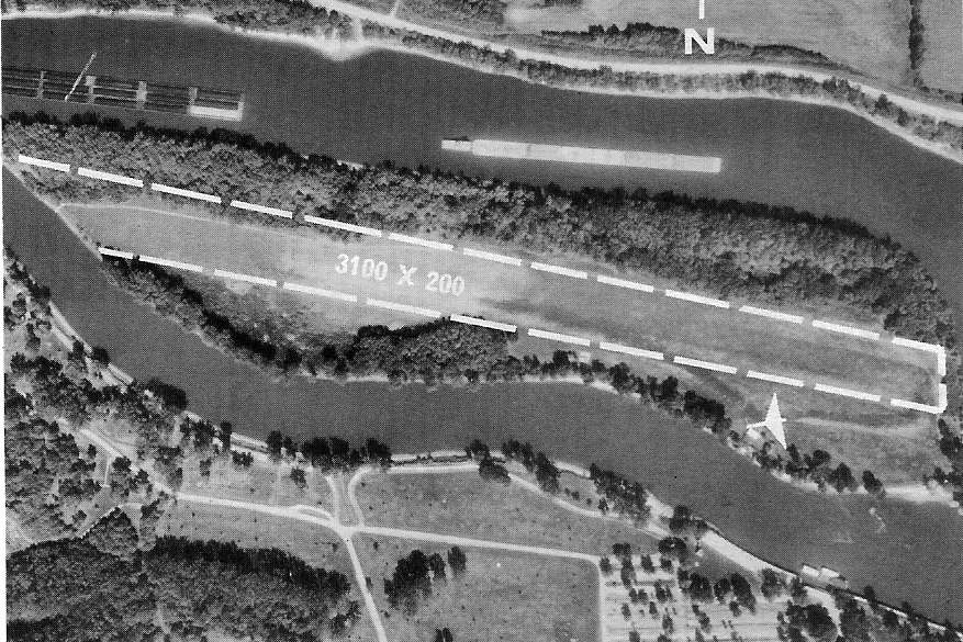
The earliest photo which has been located of Starved Rock Airpark was an undated aerial view from the 1956 IL Airport Directory (courtesy of Gregg Maryniak).
It described Starved Rock Airpark as having a 3,400' northwest/southeast turf runway, managed by Walter Hahn.
Starved Rock Airpark was not yet depicted on the 1958 USGS topo map.

A July 1961 photo by Werigg showed 1 single-engine taildragger at Starved Rock Airpark.
A July 1961 aerial view by Werigg of Starved Rock Airpark.
Werigg recalled, “Our family went on the airplane ride, 5 kids in the back seat with 1 big seatbelt, Mom in copilots seat. Not sure if it was a SR7 or SR10 Stinson Reliant.”
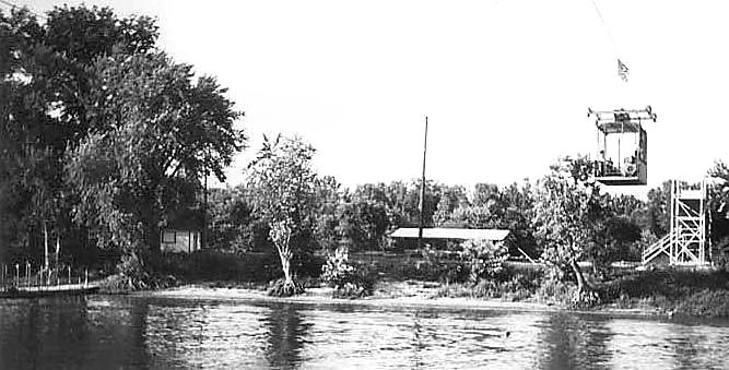
A 1961 photo of the cable car which brought visitors across the river to Starved Rock Airpark.
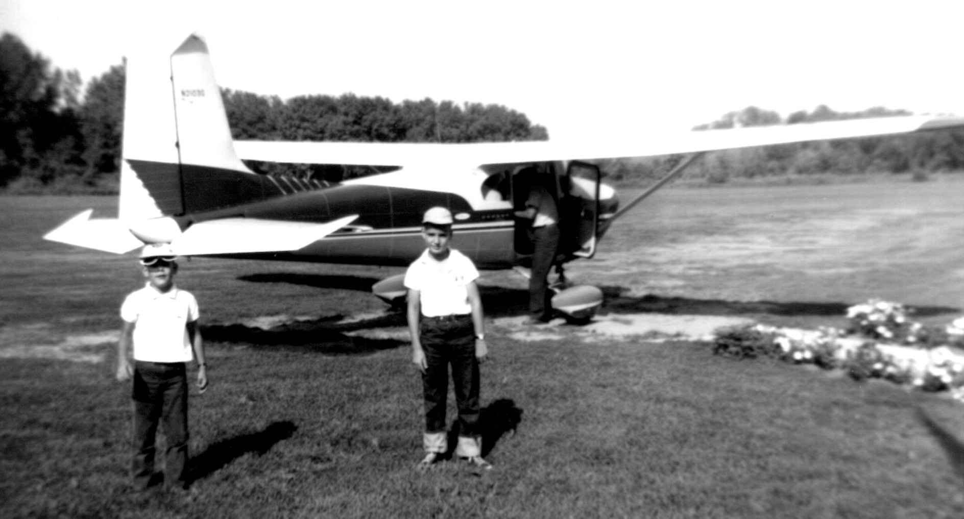
An August 1962 photo of Gregg Maryniak & his brother & a Cessna 182 at Starved Rock Airpark.
Gregg recalled, “I took my first airplane ride during the Summer of 1962 at the Starved Rock State Park Airport on Plum Island.
Although the airport had been in business for years & was originally 'connected' to the mainland by boats, at some point a cable car was added & it was pretty thrilling for the 8 & 6 year old boys to traverse half of the Illinois River to get from the South shore to Plum Island.
Once there, we waited our turn & then walked out to a very nice 1950s vintage (pre Omni-Vision) Cessna 182. Note the flowers planted alongside the pathway.”
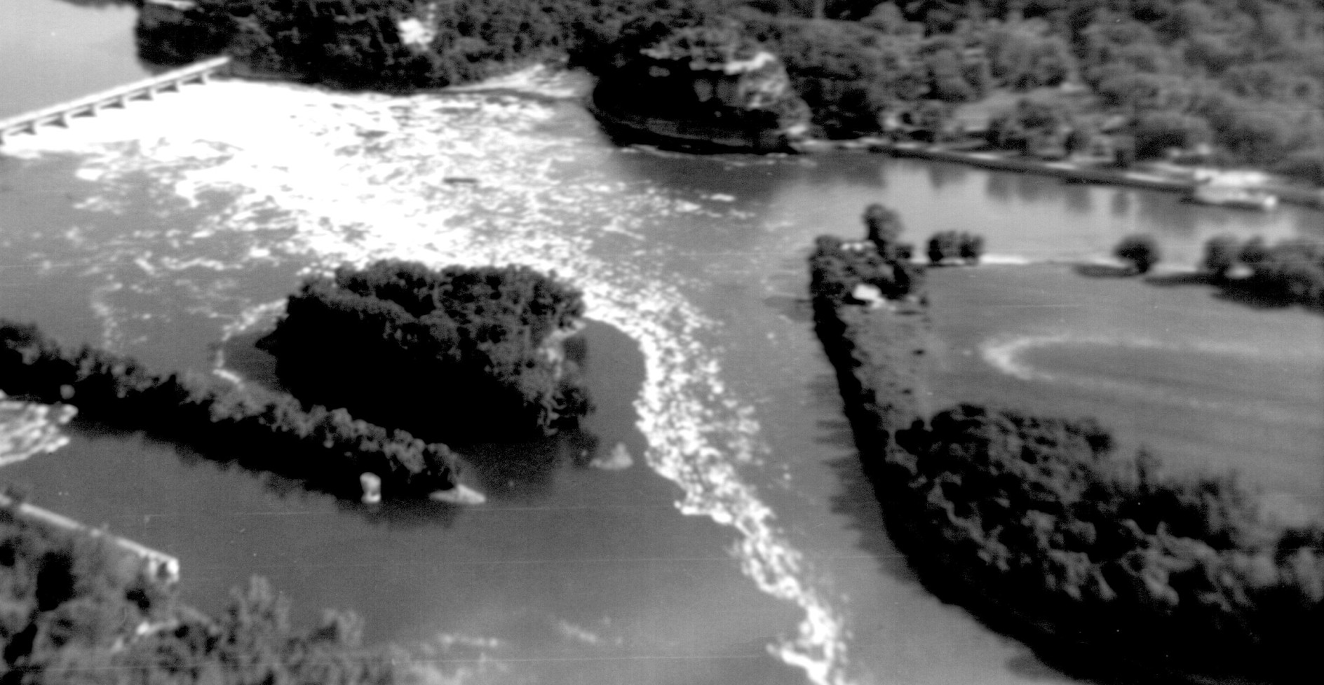
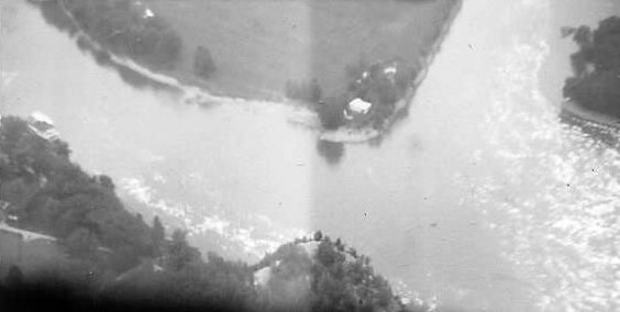
An August 1962 aerial view by Gregg Maryniak looking south at the west end of Starved Rock Airpark, showing one of the cable cars which crossed over the river to the island airport.
Gregg recalled, “We took off to the West & my father, little brother and I could see the dam across the river (just East of Plum Island).
The convention was to take off to the West & land to the East (which no doubt minimized the taxi & turn-around time between flights).”
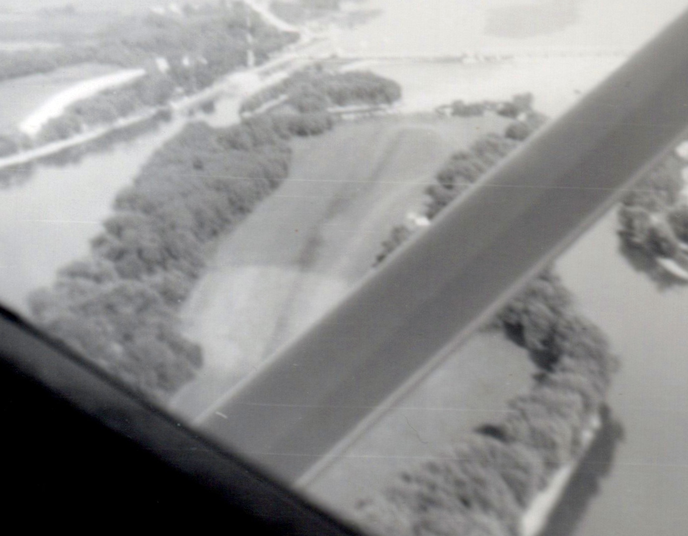
An August 1962 aerial view by Gregg Maryniak looking east at Starved Rock Airpark.
Gregg recalled, “I remember the feeling that the world was turning beneath us rather than a sense of speed which I had expected.”
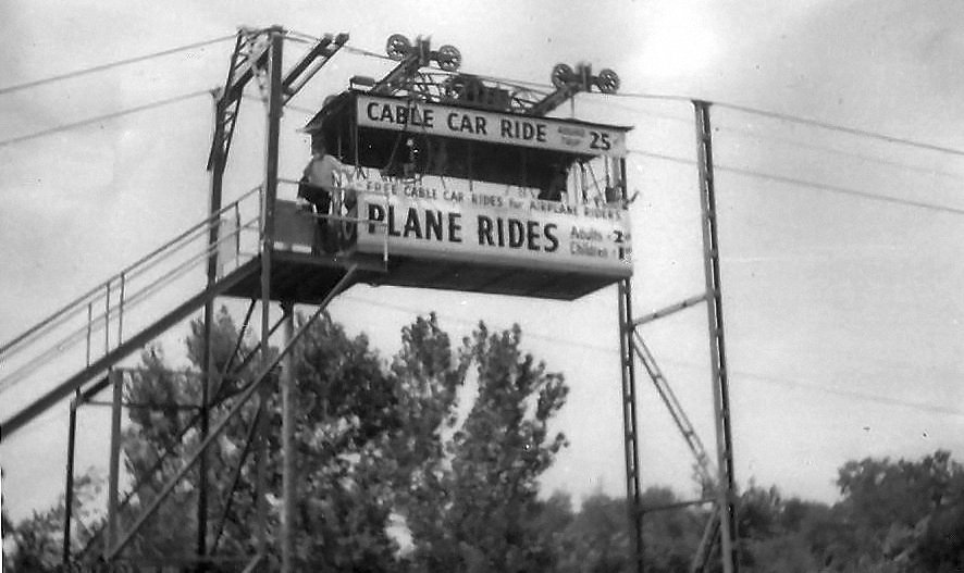
An August 1965 photo of the cable car which brought visitors across the river to Starved Rock Airpark for plane rides.
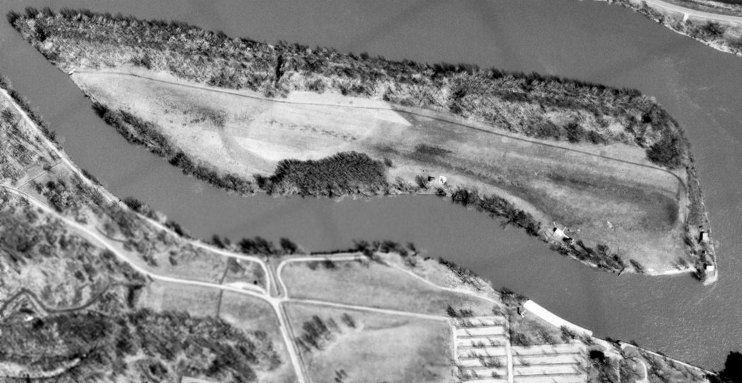
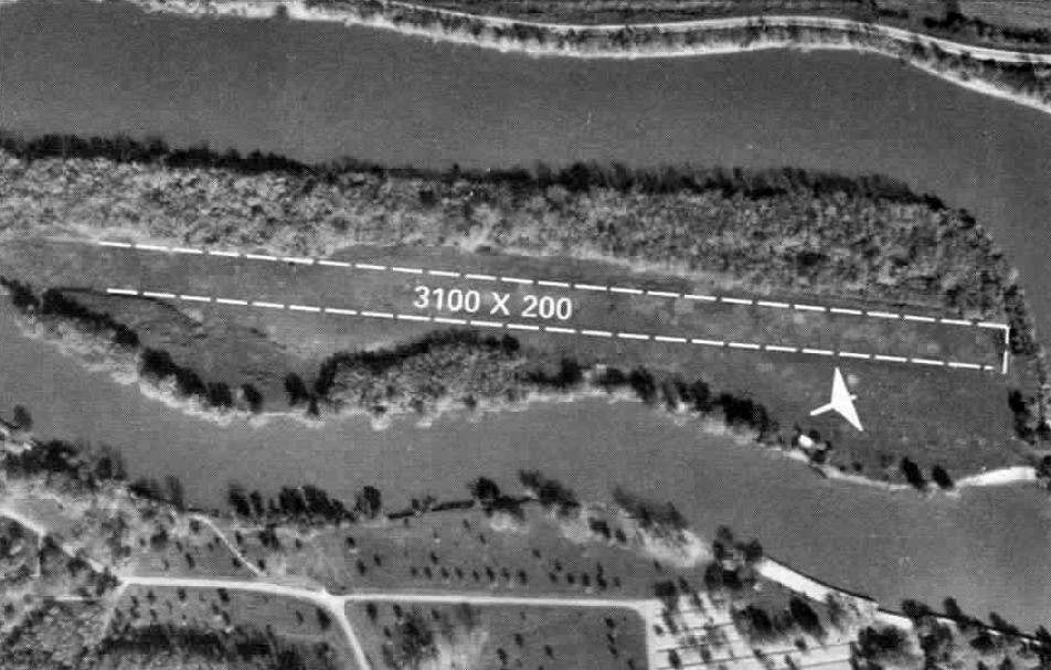
A 3/19/67 USGS aerial view depicted Starved Rock as having a northwest/southeast grass runway which occupied most of the length of the island.
A few small buildings were located at the east end.
The 1968 Flight Guide (courtesy of Robert Levittan) depicted Starved Rock as having a 3,100' unpaved Runway 10/28.
Jeff Morris recalled, “I had an introductory flight at Starved Rock Airpark [in 1969].
I was 12 years old at the time & my parents made a stop here during a coast-to-coast automobile trip from Nova Scotia.
We must have camped at Starved Rock State Park & I was lucky that my folks gave me the opportunity for a short flight.”
The 1970 USGS topo map depicted Starved Rock Airpark as having a northwest/southeast unpaved runway, with a few small buildings at the east end,
along with the cable car connecting the island to the mainland.
In 1970 flood waters in the IL River forced closure of the aerial tramway connecting Plum Island & Starved Rock State Park.
Gregg Maryniak recalled, “Starved Rock Airport was still in operation & I remember flying over it during my first solo cross-country flight in 1970.”
The 1972 IL Airport Directory (courtesy of Bill Pagett) depicted Starved Rock as having a 3,100' northwest/southeast grass runway.
According to the book “Starved Rock State Park, The First 100 Years” by Mark Walczynski, aerial tours of the park were discontinued in 1975.
The last photo which has been located showing Starved Rock Airpark still in operation
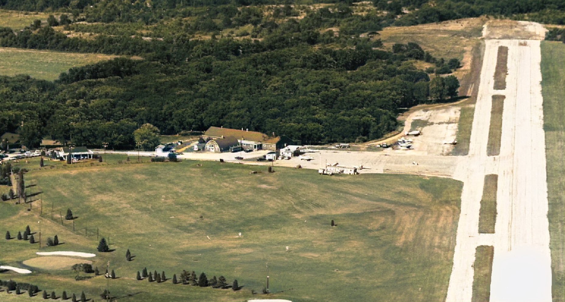
was an undated aerial view from the 1978 IL Airport Directory (courtesy of Bill Pagett).
It listed the manager as Walter Hahn, and said that “Cable cars available to park summer months.”
The last aeronautical chart which has been located showing Starved Rock Airpark was on the 1979 Sectional Chart (courtesy of Bill Pagett),
which depicted Starved Rock as having a 3,200' unpaved runway.
According to Bill Pagett, “It closed sometime after 1979 as I did not find it listed in the 1980 Illinois [Airport] directory.
I made a huge mistake & landed on the grass runway after the airport had closed.
I did not call the phone number listed as we were already in the air & I just remembered it was there & we were on our way.
It was on a July 4th & my wife & I were flying around looking for someplace to just relax for the day.
We had packed a picnic lunch & we were looking for a country grass strip to land, have lunch, and just relax.
It could not have been long after the airfield closed as from the air, there were no 'closed' markings & the landing area looked to be maintained.
There were no radio advisories available.”
Bill continued, “Once committed to a landing, and settling in from the flare,
I realized that the grass that from the air that looked to be mowed, was brushing the underside of my Cherokee 140's wings.
Needless to say, our ground roll was dramatically shortened by the tall grass grabbing at the landing gear.
Thankfully, I had wheel pants or the stop would have been a bit quicker.
At the west end of the strip, and with more throttle than usual, I did a 180 to assess the problem I now had.
As I turned around, I saw 3 wheel tracks where the grass had been laid down by the landing gear.
I informed my wife of the huge error I had made & formulated a plan to taxi back-&-forth 3 or 4 times
to flatten a suitable path for us to beat a hasty departure into the prevailing winds.
We did so without attracting much attention from anyone across the water in the state park
and without fanfare, successfully departed a rather embarrassing situation.”
A local resident reported that “Mr. Pagett was not the only one to land on the Plum Island field after it was no longer in use.
Another pilot with his wife & children landed there safely. He swam across the Illinois River to the park & got assistance from park personnel & others.
There was an old tractor/mower on the island; they got it started & mowed an area for the pilot to take off from.
His family returned to their home by car while he flew the plane off the island.”
Starved Rock Airpark was no longer depicted on the October 1993 Sectional Chart (courtesy of Ron Plante).
Plum Island was listed for sale again in 6/23/00.
As of 2/6/02, developer Don Barclay no longer planned to build a resort & conference center on Plum Island,
but instead envisioned luxury townhouses.
Later in 2002 the Village of Utica began annexation of Plum Island.
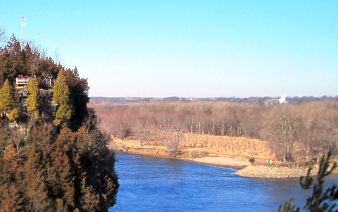
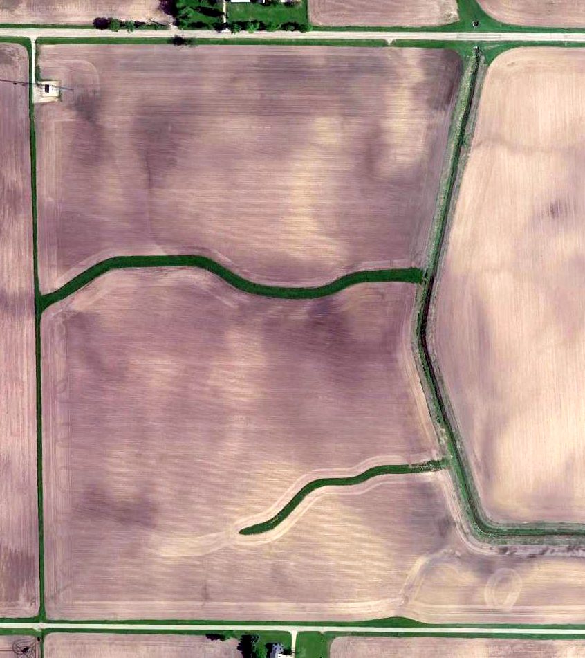
In a 12/29/11 photo looking northwest at the site of Starved Rock Airpark,
the photographer noted “some of the tree plantings on what had been the airstrip can be seen.”
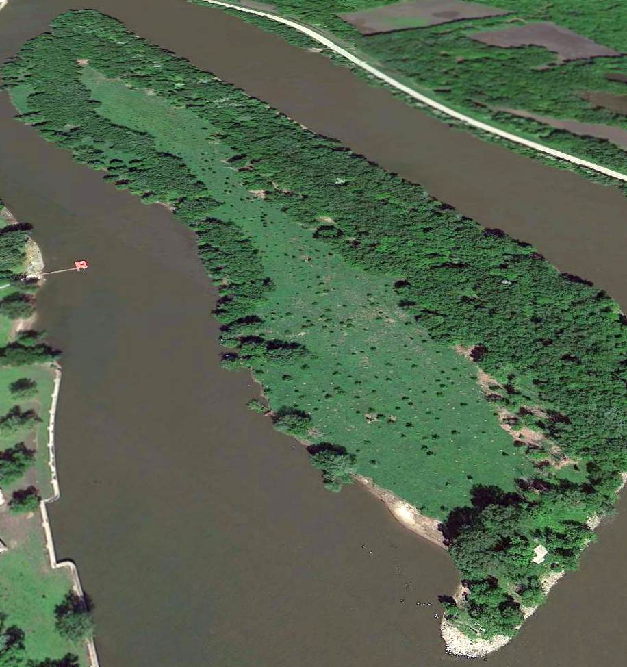
A 5/23/13 aerial view looking west shows the site of the Starved Rock runway remains mostly clear,
and what may be the foundation of a former airpark building is visible at the lower-right.
A local resident reported in 2014, “The island has become a nature preserve & groups have gone out there in the past few years to clear it of debris & to plant trees.
There were a couple of private homes on the island for years at the east end but they have been removed since it became a nature preserve.
One of the residents had one of those Aqua Cars - a car/boat combination - for years & used it as transportation from the state park to the island.”
Thanks to Bill Pagett for pointing out this airfield.
____________________________________________________
(Original) Rockford Airport / Machesney Airport (KRMC), Machesney Park, IL
42.35, -89.054 (Northwest of Chicago, IL)
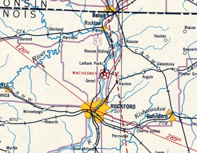
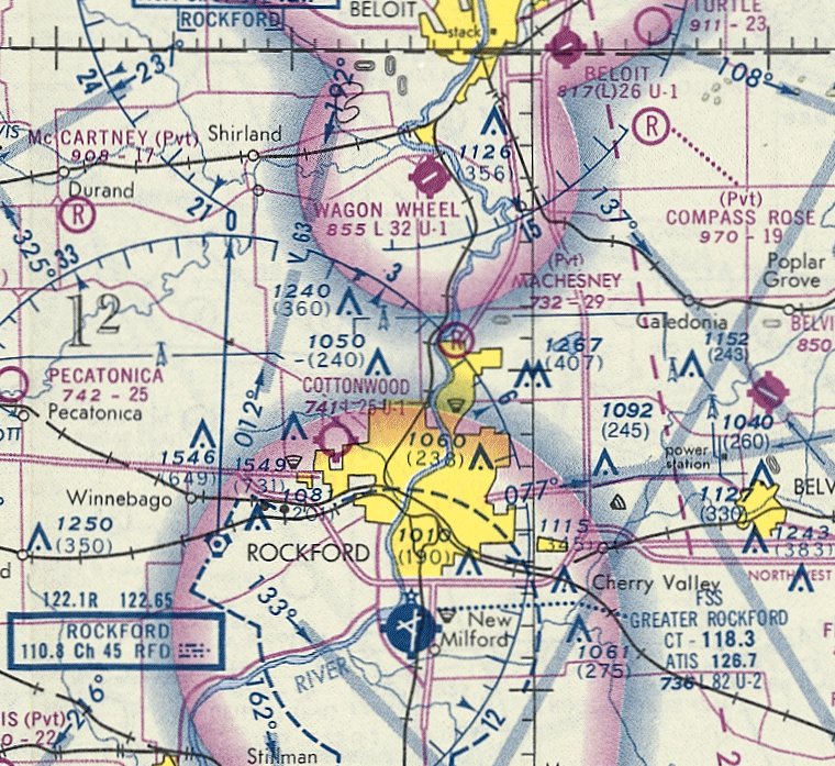
Machesney Airport, as depicted on the June 1931 Milwaukee Sectional Chart.
According to the Village of Machesney Park, “In June 1927 Fred Machesney came to the Rockford area
and acquired rights to a 55-acre tract of land & it eventually expanded to 160-acres.
It officially became the 'Rockford Airport' on 7/8/27 where it was high, a well-drained field,
and was comprised of 160 acres touching North 2nd Street / Road (east),
extending to the west along the Rock River, and making the airport accessible to seaplanes for a landing.
On the field there were 3 hangars, 60' square with a 14' clearance, capable of housing 12 standard airplanes.
Two additional smaller hangars provided space for 3 more aircraft. There was a workshop, classroom, and waiting room.”
According to the Village of Machesney Park, “It was Mr. Machesney’s thoroughness & unusual precautions on the part of each & every pilot that he employed
which enabled him to point with pride to a 'no accident' record during the 1928 flying season.
More & more people made use of the aircraft for transportation purposes.
Almost midway through the year, May 1928, Mr. Machesney took delivery of a 5-place Fairchild cabin plane, which included the pilot.
Mr. Machesney bought the plane to increase his passenger carrying capacity & his income.
Whether the travel was for pleasure, business or shopping trips to Milwaukee or Chicago,
it was now possible by means of the Fairchild Cabin Plane used by Mr. Machesney.”
According to the Village of Machesney Park, “The new aircraft was able to travel at a speed of 90 MPH under favorable conditions.
At this speed, travelers, shoppers, and businessmen were able to reach the Wisconsin metropolis, Chicago, or other distant cities in a remarkably short time.
During his career Fred Machesney flew more than 100,000 miles, quite a record for any pilot.
This moved the Rockford area manufacturers, businessmen, and salesmen into a position to compete with those of other cities
who already knew the value of the aircraft in exceeding the competition.
Also the same year new equipment was arriving on Machesney’s field from the newly formed Forest City Airways,
which operated out of the Blackhawk field, which they placed an Air King biplane, thus increasing Rockford’s passenger carrying air fleet to 4.”
According to the Village of Machesney Park, “Notably on 8/16/28 marked a 2nd flight attempt to Sweden from the Rockford Airport,
whereby the pilots were lost between August 18 & September 2, 1928 in Greenland.
They were safely returned to a warm reception on 10/18/28.”
According to the Village of Machesney Park, “When the air mail service was proposed for Rockford,
a revolving beacon was removed from atop the Rockford National Bank building, which was donated & installed at the airport.
It was used in connection with the flood lighting system installed from assistance by the aviation committee of the Rockford Chamber of Commerce.
Obstruction lighting was installed to mark hazards for pilots flying at night to mark the property boundaries.
Northwest Airways, Inc., who flew the mail in & out of the area put their stamp of approval on the airport in one visit (1930).
Fred Machesney was instrumental in getting airmail delivered to the area, which lasted from 1930-33.”
The earliest depiction which has been obtained of Machesney Airport was on the June 1931 Milwaukee Sectional Chart.
According to the Village of Machesney Park, “Some of the individuals who worked at the airport were:
Ralph Swaby, pilot, 1927. Howard Adams, mechanic, 1935, and pilot 1942.
R.S. Day, chief pilot & operations officer, 1940-49. B.W. 'Sandy' Sandberg, pilot & operations manager, 1934.
Chuck Kissel, chief pilot & flight examiner, 1942-52. Ray Bloomster, flight instructor & pilot, 1947-52.
Robert Miller, shop superintendent, civil aeronautics authority & aircraft inspector, 1943-52.”
According to the Village of Machesney Park, “Fred Machesney & Ralph Swaby, who was the first pilot Fred hired, were transport pilots.
He & Fred flew 800 hours, covered 60,000 miles, carried 3,600 passengers (short hops & cross country),
and they successfully took off & landed over 4,000 times.
The airport had 203 visiting aircraft & it became a favorite stopping place for flyers of the Army & Navy
who made hops from Chanute Field at Rantoul, and Great Lakes Naval Training Station at North Chicago.”
According to the Village of Machesney Park, “In 1930 Northwest Airlines expanded its passenger services to Elgin & Rockford,
routed to Machesney Field, which they had already approved as a route for airmail delivery with just one visit previously.”
According to the Village of Machesney Park, “In 1934, Fred went back to operating 3 or 4 planes & was doing most of the flying again.
Extra passenger work was being handled by 'Sandy' Sandberg & Pat Bailey.
In 1935 famed aviatrix Amelia Earhart visited Rockford & addressed the Woman's Club.”
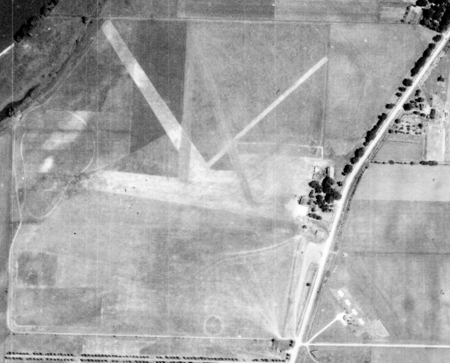
The earliest photo which has been obtained of Rockford Airport was a 7/3/39 IL State Geological Survey aerial view.
It depicted Rockford as having 3 grass runways, with a few small buildings (hangars?) along the east side.
According to the Village of Machesney Park, “Fred received a boost in the winter of 1939 when his airport, in co-operation with Beloit College,
instituted a Civilian Pilot Training Program with about 10 students in the first class.
This was followed by several classes being formed for pilots & instructors for Army primary schools,
and Army Air Corps cadet’s indoctrination training under the War Training Service in 1943.
The airport was a stop over spot for United States military planes heading over to the Sovit Union during World War II.
From 1939-43, 1,139 students in military service were trained at the Machesney Rockford Airport,
and an estimated 2,000 civilian students completed the training during the same time period.”
According to the Village of Machesney Park, “On 11/16/43, voters approved the formation of the Greater Rockford Airport Authority.
The law was later found unconstitutional, but the authority was approved & created 2 years afterward.”
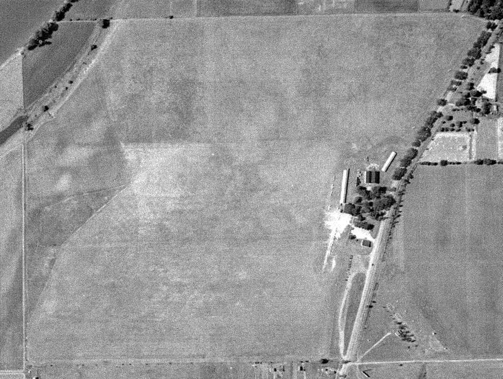
A 10/5/45 USGS aerial view depicted Machesney Airport as having a roughly squared-shaped grass airfield
with several hangars & at least 3 single-engine aircraft along the east side.
The 1949 USGS topo map depicted “Machesney Landing Field” as an irregularly-shaped area with several buildings along the east side.
According to the Village of Machesney Park, “In 1951, 237 charter passengers were carried on 143 trips
for a total of 55,155 passenger miles, as told by Fred Machesney.
There were 35 airplanes based at the Machesney Field, whereby Fred was operating 11 of them.
Freight handling aircraft flew 12,380 miles, transporting 10,828 pounds of cargo during 1951.
In January 1952, the total hours flown were 76,330, air miles estimated at 7,633,000
with more than 75,000 passengers carried by the planes that landed at the airport.”
Harold Bish recalled, “I instructed there in the 1950s.”
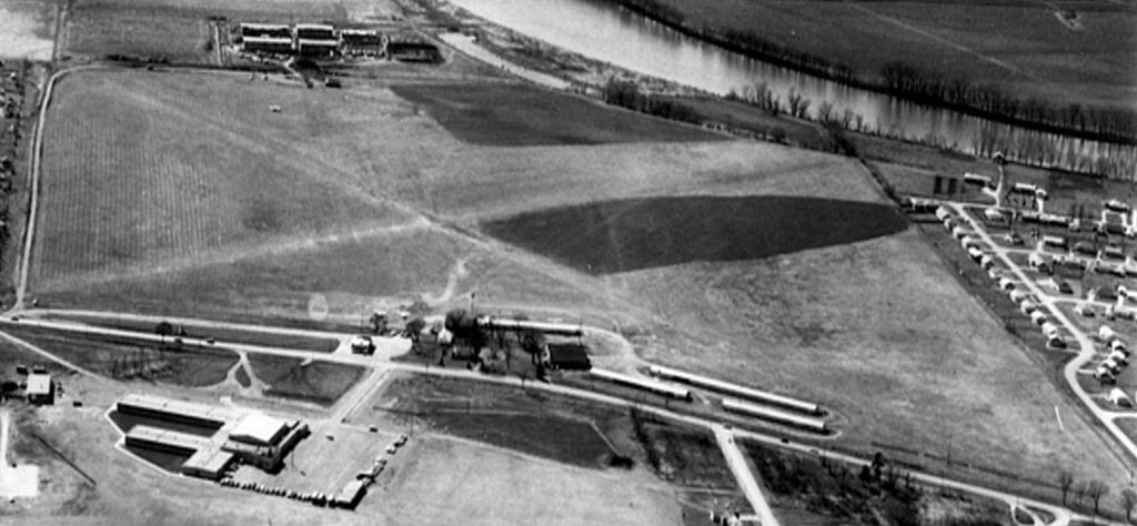
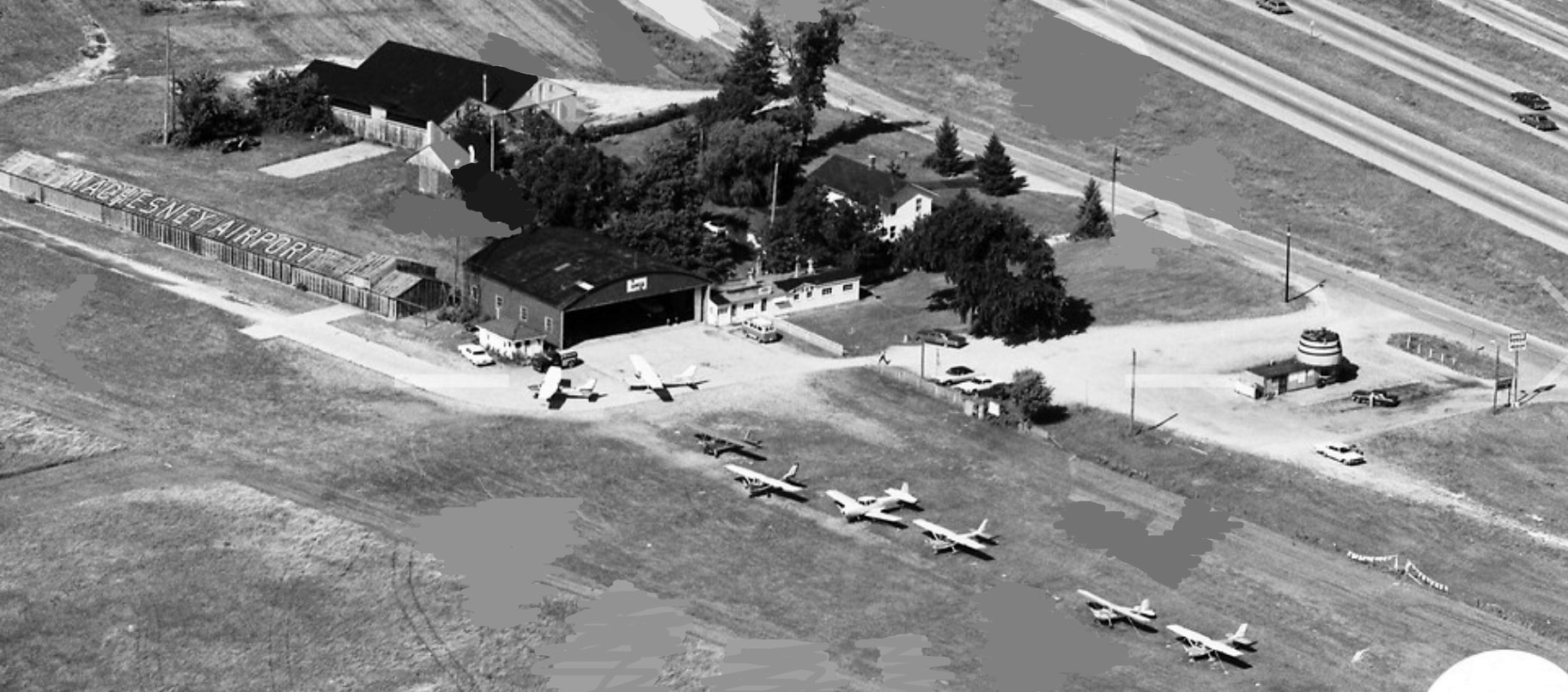
A 1962 aerial view looking west (courtesy of Michael Abernethy)
showed that Machesney Airport had gained several more rows of hangars at some point between 1945-62.
The outlines of 2 grass runways were visible on the airfield.
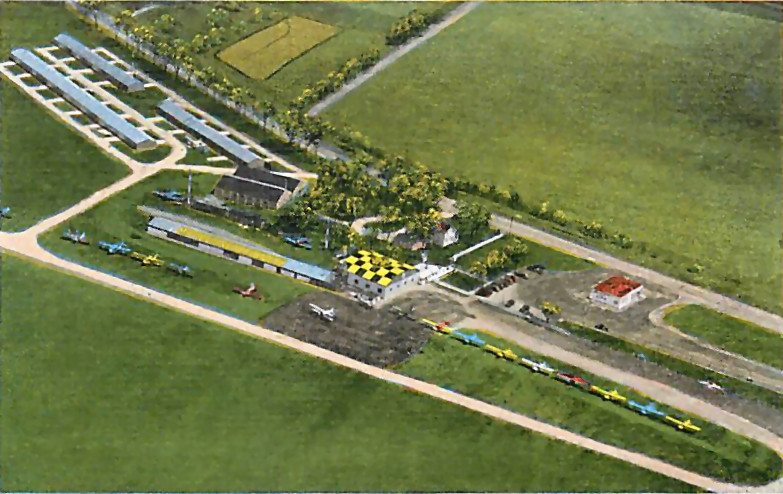
A circa 1960s colorized aerial view looking west depicted Machesney Airport at perhaps its zenith of popularity,
with 17 single-engine aircraft visible parked outside, along with 5 hangars & other buildings.
According to Wikipedia, “A tornado in 1966 damaged hangars & aircraft at the airport.”
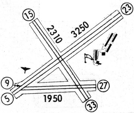
The 1968 Flight Guide (courtesy of Robert Levittan) depicted Machesney Airport as having 3 unpaved runways, with the longest being 3,250' Runway 5/23.
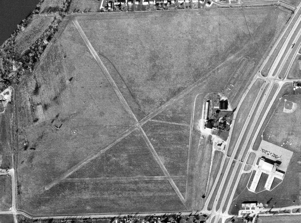
A 10/7/70 USGS aerial view depicted Machesney Airport as having 3grass runways.
But the airport appeared to be in a state of steep decline, as the 3 rows of T-hangars on the northeast side had been removed at some point between 1962-70,
and only a sole aircraft was visible parked outside.
According to Harold Bish, Machesney Airport “was the oldest longest operating Fixed Base Operator in the U.S.”
The 1973 USGS topo map depicted Machesney Airport as having 3 unpaved runways.
A 1973 aerial view looking northeast (courtesy of Mike Denja) west depicted 7 light single-engine planes parked near the hangars on the east side of Machesney Airport.
Mike Denja noted, “The barrel-shaped restaurant [adjacent to the airport, right side of picture] was the Huskies A&W Root Beer Barrel.”
The last aeronautical chart depiction which has been located of Machesney Airport was on the November 1974 Chicago Sectional Chart (courtesy of Ron Plante).
It depicted Machesney as a private airfield having a 2,900' unpaved runway.
According to the Village of Machesney Park, “In 1974 with the continued decline of the Machesney Airport operations
it closed 20 years after the opening of the Greater Rockford Airport.”
However the 1977 USGS topo map continued to depict Machesney Airport as having 3 unpaved runways.
According to the Village of Machesney Park, “Not long after its closing the property was redeveloped as the Machesney Park Mall (1978).”
Machesney Airport was no longer depicted on the October 1993 Chicago Sectional Chart (courtesy of Ron Plante).
Ironically as of 2013 the Machesney Park Mall was described as a “dead mall”, with most of its stores vacant, and reportedly planned for demolition.
Maybe the nice little airport could've stayed there after all?
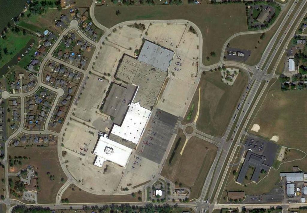
A 9/9/13 aerial view of the mostly-vacant Machesney Park Mall, with no trace remaining of the Machesney Airport.
The site of Machesney Airport is located northwest of the intersection of Route 251 & Machesney Road.
____________________________________________________
Ottawa Airport / Skydive Chicago Airfield (C13), Ottawa, IL
41.364, -88.86 (Southwest of Chicago, IL)
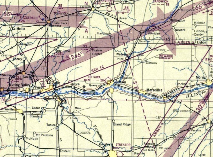
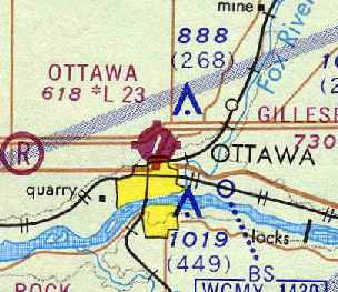
Ottawa Airport, as depicted on the June 1947 Chicago Sectional Chart.
Ottawa Airport was apparently built at some point between 1946-47,
as it was not depicted on the December 1946 Sectional Chart nor on the 1946 USGS topo map.
The earliest depiction which has been located of Ottawa Airport was on the June 1947 Chicago Sectional Chart.
It depicted Ottawa Airport as having a 2,600' unpaved runway.
The earliest photo which has been located of Ottawa Airport was an undated aerial view in the 1956 IL Airport Directory (courtesy of Chris Kennedy).
It depicted Ottawa Airport as having a 2 turf runways: a 2,800' north/south & a 2,000' east/west strip.
The operator & manager was listed as Julius Corsini.
Ottawa Airport had gained a paved runway at some point between 1956-62,
as the 1962 IL Airport Directory (courtesy of Jonathan Westerling)
depicted the field as having a 2,300' paved Runway 5/23, in addition to the 2 previous turf runways.
Several buildings were depicted on the north side of the field.
The operator was listed as Ottawa Flying Service, and the manager was listed as Julio Corsini.
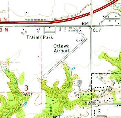
The 1970 USGS topo map depicted Ottawa Airport as having a paved northeast/southwest runway
with a ramp leading to a cluster of buildings on the north side of the field.
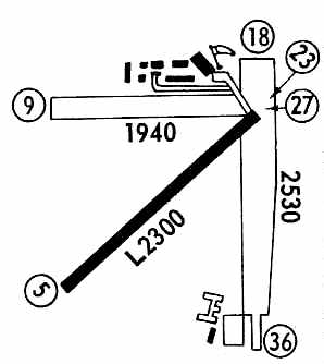
The 1971 Flight Guide (courtesy of Chris Kennedy) depicted Ottawa Airport
as having a 2,300' paved Runway 5/23 & 2 turf runways.
A total of 7 buildings (hangars?) were depicted on the north side of the field.
Ottawa Airport, as depicted on the May 1971 Sectional Chart (courtesy of Chris Kennedy).
The paved runway at Ottawa was lengthened at some point within the next decade,
as the 1982 AOPA Airport Directory (courtesy of Ed Drury)
described the field as having a 3,400' asphalt Runway 5/23, in addition to the 2 turf runways.
The field was described as offering charter, flight instruction, fuel, and tiedowns.
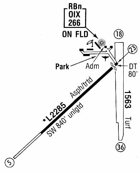
The 1986 Flight Guide (courtesy of Chris Kennedy)
showed that the primary (paved) Runway 5/23 had gained an 840' overrun on the southwest end.
The 1,563' turf Runway 18/36 was still open,
but the former turf Runway 9/27 had apparently been abandoned.
The field had also gained its own NDB navigational beacon,
located adjacent to the cluster of buildings on the north end of the field.
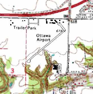
The 1993 USGS topo map depicted Ottawa Airport as having a single paved runway.
Ottawa Airport was renamed "Skydive Chicago" Airfield at some point between 1993-98,
as that is how it was depicted on the 1998 World Aeronautical Chart.
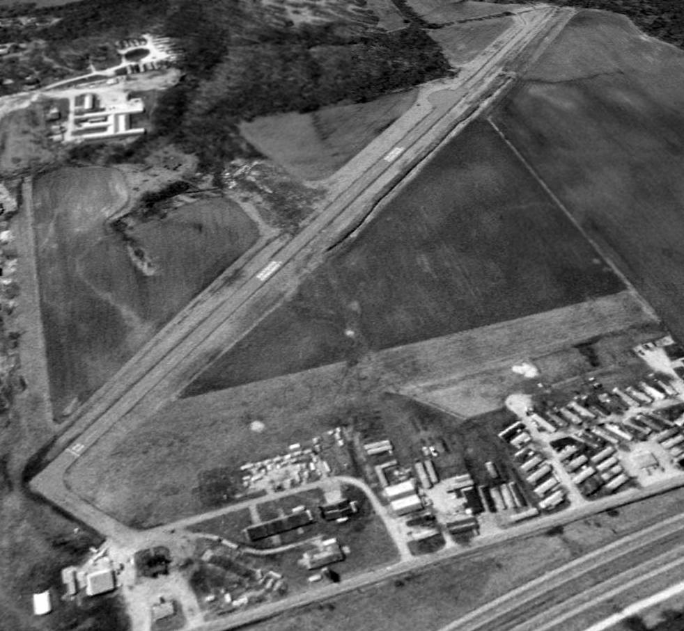
A 1998 USGS aerial view looking southwest was apparently taken while the airport was still open.
A single aircraft is visible next to a building at the northeast corner of the field.
The 2 former grass runways were still intact.
In June of 1998, Skydive Chicago Airfield was relocated (for reasons unknown) to a new field 4 miles northeast of the town of Ottawa,
and Ottawa Airport was presumably closed at that point.
According to a local resident, “The Ottawa Airport / Skydive Chicago site was sold, probably after the death of Mr. Corsini who was the owner/operator.
Skydive Chicago had used the airport as a base of operations for a number of years before the sale.
They eventually moved northeast of Ottawa to a small town named Dayton.”
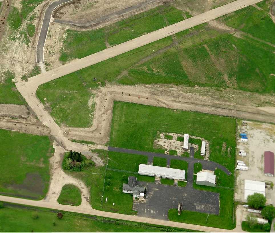
A circa 2007 aerial view looking south at the remains of Ottawa Airport showed that the paved Runway 5/23 remained intact (with a closed runway X symbol),
along with several hangars & some other airport buildings.
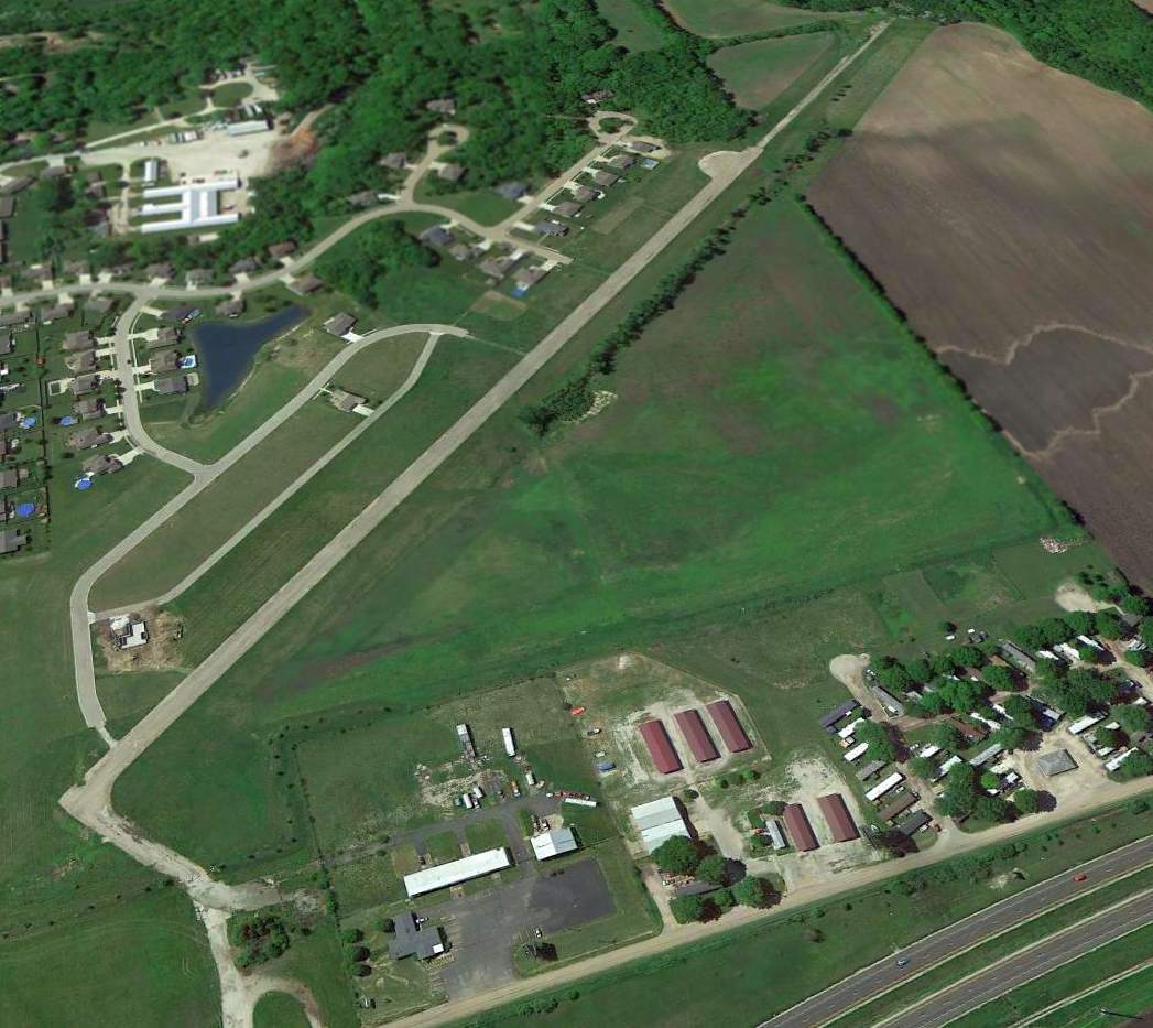
A 2013 aerial view looking southwest showed that the paved runway remained intact, along with one grass runway,
but houses had been built along the southern portion of the former grass Runway 18/36.
Several hangars remained standing on the north side (foreground).
A 12/31/14 photo by a local resident looking southwest along the concrete strip from the road on the east side of the site of Ottawa Airport.
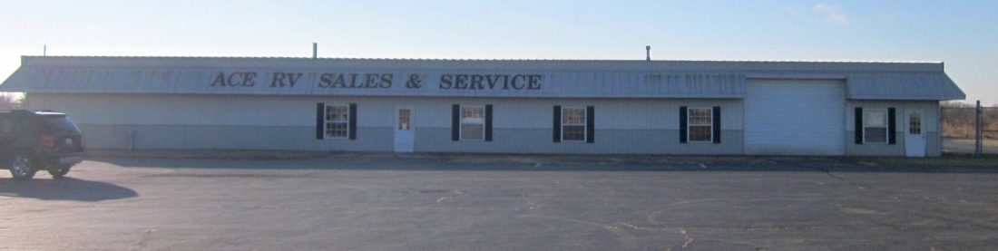
A 12/31/14 photo by a local resident of a former Ottawa Airport hangar.
The photographer reported, “The buildings are part of a mobile home sales company - they expanded into the area where the hangars used to be.”
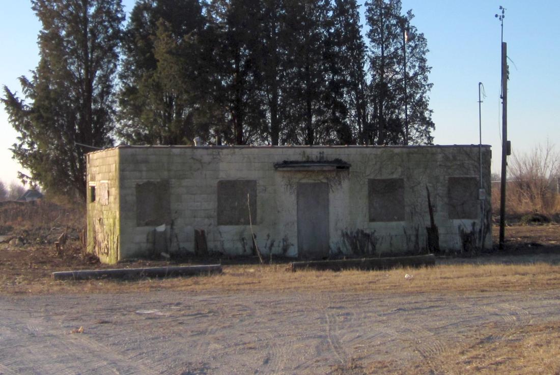
A 12/31/14 photo by a local resident of the former Ottawa Airport office building – note the wind sensors on top of the pole on the right.
An 8/10/16 photo of the site of Ottawa Airport, showing that the Operations/Office building had been removed at some point between 2014-2016.
A 10/31/16 photo looking along the remains of the Ottawa Airport runway.
A 1/9/17 photo looking west along the remains of the Ottawa Airport runway.
The photographer reported, “This past summer they’ve been installing water lines along East 16th Road which runs on the east boundary of the old airfield so that might be why the stone & equipment was there.
You can drive through the subdivision & get to the strip.
There are concrete barricades to keep traffic from getting onto the strip but no signs saying to keep out.
The couple of streets bordering the area all have 'Lot for Sale' signs on them so I’d guess they are planning on expanding the subdivision.”
A 1/9/17 photo looking west along the remains of the Ottawa Airport runway, showing the closed-runway “X” which is still visible.
The site of Ottawa Airport is located south of the intersection of North 30th Road & Airport Road, appropriately enough.
____________________________________________________
Wagon Wheel Airport (C80), Rockton, IL
42.44, -89.073 (Northwest of Chicago, IL)
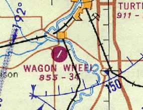
Wagon Wheel Airport was depicted simply as “Landing Field” on the 1959 USGS topo map.
The Wagon Wheel Airport was apparently part of the Wagon Wheel Resort.
According to a 2001 article in the Beloit Daily News,
the Wagon Wheel Resort itself was founded in Rockton by Walt Williamson in 1936.
The original resort burned in a 1945 fire,
but was rebuilt & became a Mecca for celebrities such as Bob Hope & James Dean to perform & vacation.
At its peak, the Wagon Wheel boasted more than 200 rooms, a banquet hall, bowling alley, shops,
candy kitchen, theater, swimming pools, ice skating rink and a church.
The date of construction of the Wagon Wheel Airport has not been determined,
but it may have been built at some point between 1956-59,
as it was not yet depicted on a 4/14/56 USGS aerial photo, nor listed among active airfields in the 1956 IL Airport Directory (according to Chris Kennedy).
The earliest depiction which has been located of Wagon Wheel Airport was on the 1959 USGS topo map.
It depicted a single paved northeast/southwest runway, with a paved ramp & a single building on the northwest side,
labeled simply as “Landing Field”.
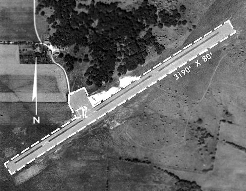
The earliest photo which has been located of Wagon Wheel Airport
was a circa 1961 aerial view in the 1962 IL Airport Directory (courtesy of Jonathan Westerling).
It depicted the field as having a single 3,190' bituminous northwest/southeast runway, with a paved ramp along the northwest side.
There did not appear to be any buildings directly at the airport.
The operator was listed as Wagon Wheel Resort, and the manager was listed as Walter Williamson.
The earliest aeronautical chart depiction which has been located of Wagon Wheel Airport
was on the May 1962 Milwaukee Sectional Chart (courtesy of Chris Kennedy).
It depicted Wagon Wheel as having a single 3,400' paved runway.
According to Harry Fenton (who worked at the Wagon Wheel Airport from 1977-80),
“Beyer Aviation (Al Beyer, aka, Beyer the Flyer) was the operator from the early 1970's.”
According to a 2002 article in the Beloit Daily News,
Joyce Beals returned to the Wagon Wheel Resort in 1970 to head its airport.
Beals' duties included giving lessons, selling gasoline and chartering flights.
Between her days working inside the resort & on the airstrip, Beals saw her share of celebrities.
Like most employees of the famed resort, she did not know who was going to arrive in advance.
"The celebrities were a deep dark secret because Miss Manners did want people knocking on her door,'' Beals recalled.
She remembers John Wayne, Ronald Reagan and Shirley Temple visiting the resort,
as well as Jack Nicklaus flying into the airport & taking in a round of golf at the Wagon Wheel's golf course.
Race car driver Bobby Allison used the resort & airport as a stop-over when racing in Rockford.
The 1971 Flight Guide (courtesy of Chris Kennedy) depicted Wagon Wheel Airport
as having a single 3,200' paved Runway 5/23, along with a parallel taxiway on the northwest side
in the middle of which was a ramp, with two small buildings (hangars?).
It indicated that the field was attended during days.
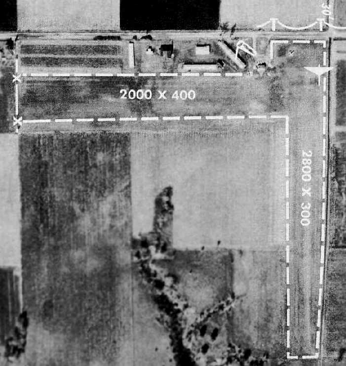
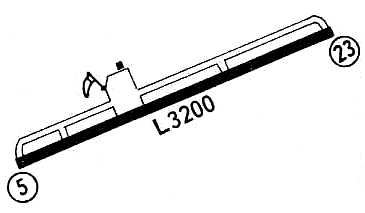
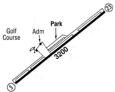
An aerial view of Wagon Wheel Airport from the 1972 IL Airport Directory (courtesy of Bill Pagett).
The directory depicted the field as having a single 3,200' bituminous Runway 5/23,
with a paved ramp along the northwest side of the field with several buildings.
The operator was listed as Beyer Aviation, with the manager being Al Beyer.
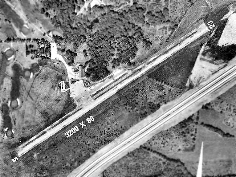
The last photo which has been located showing aircraft at Wagon Wheel Airport was a 1973 aerial view looking northeast (colorized by Mike Denja).
Seven light single-engine aircraft were parked on the north ramp.
According to a 2002 article in the Beloit Daily News, taking good care of the airport
brought Wagon Wheel Airport manager Joyce Beals notoriety from the resort's owner, Walt Williamson.
In 1975, deciding the buildings at the airport needed a new coat of paint,
Beals purchased both red & white paint for the job.
But unlike the rest of the resort, which was mainly red with white trim,
Beals painted the buildings white & used the red for trim.
She became nervous when Williamson came out to inspect the paint job.
To her surprise, Williamson was pleased with the painted buildings,
and as a thank you invited Beals to dine with him at his table that night.
While eating that night, Williamson asked Beals if she needed anything for the airport.
When she told him she could use a few airplane hangars,
he arranged for the ground to be excavated the next day, and lumber for the project arrived shortly after.
However, Williamson suffered a heart attack & died a few days later. "I never got my hangar," Beals said.
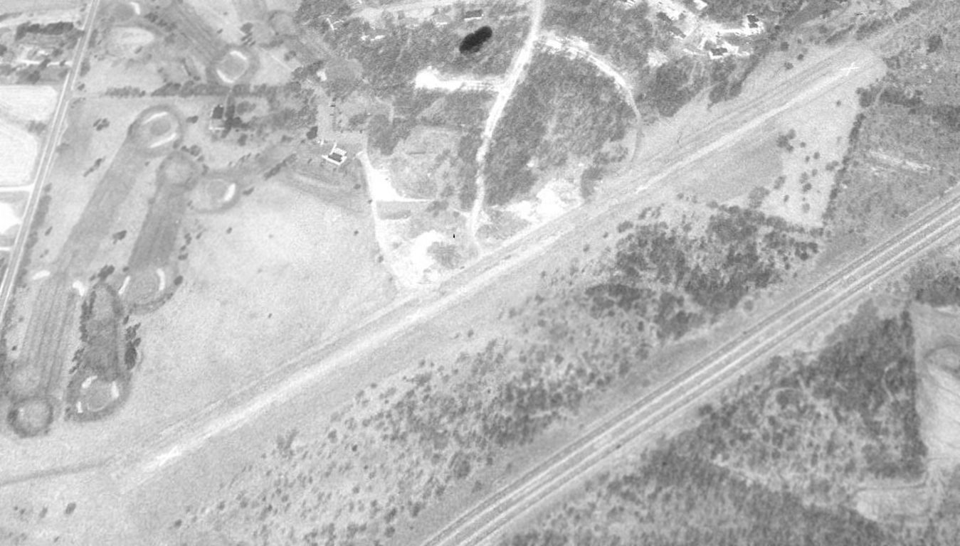
The last photo which has been located of Wagon Wheel Airport was a 4/6/76 USGS aerial view.
Steve Wilson recalled, "The first time I flew into the Wagonwheel Airport was 2/15/77.
At that time there was an FBO open regular hours, and selling fuel.
We used to fly in once in a while, and eat at the lodge
(pleasant walk was about 1/3 mile, or they would provide transportation).
One time my wife & I spent a weekend at the lodge,
and at least twice the Illinois Swift Wing held fly-ins at the Wagonwheel Airport & Lodge in the late 1970's or early 1980's."
According to Harry Fenton (who worked at the Wagon Wheel Airport from 1977-80),
“Beyer Aviation was the operator... through about 1979 when he was kicked off of the airport for back rent.
Pheasant Run Resort bought the resort & installed an FBO that they owned - Philko Aviation.
Philko ran for a year or so before folding up.”
Harry continued, “The resort was owned by Walt Williamson, and after his death, the resort & airport passed through many owners,
none of which made any improvements & the airport continued to slide into disrepair.
To be honest, in 1979 the runway surface was in pretty bad shape & needed resurfacing.”
Harry continued, “I was there on the last day of commercial operations [1980].
The airport was open for operations for a few more years, but there was no FBO, no fuel services.
There was one lone airplane based there from 1980-86, a Beech Bonanza operated by Martin Automatic for corporate use.
Martin purchased the remaining fuel inventory & pumped gas for their own use until the pump was hit by lightning & broke.”
Steve Wilson recalled, "The last time I was in the airport was on 7/02/84, after a couple years of not going there.
Grass was growing up through cracks in the runway,
the asphalt was heaving in spots, and of course there was no one around; however, NO Xs on the ends of the runway!
We walked to the lodge which was still open, and got a bite to eat.
When asked where we came from, we said "The airport."
To which the lady asked, "What airport?" I guess it had been closed longer than we thought!"
The runway configuration at Wagon Wheel Airport was depicted in the 1986 Flight Guide (courtesy of Chris Kennedy)
as being a single 3,200' paved Runway 5/23,
with a parallel taxiway leading to a parking area & ramp.
However, the status of the airport had evidently started to decline,
as it was described as "Unattended", and the remarks said "[Use at] own risk."
According to Harry Fenton, “I'm not sure of the actual date where the airport was officially closed for operations, but 1986 is as good as any.
The runway surface was utterly shot by the early 1980's
and shrubs, grass, and even small trees were breaking through the surface.
Part of the resort, including the airport,
was sold for a housing development called the Woodlands in the late 1980's / early 1990's.”
The Wagon Wheel Resort was sold in 1989 to a group of local investors.
The land was sold again in 1992, and a 5-alarm fire caused more than $1 million worth of damage to the resort.
The Wagon Wheel Airport was no longer depicted at all on the 1993 USGS topo map.
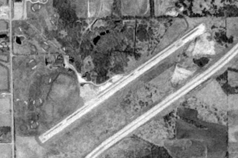
A 1994 USGS aerial view looking north at the site of Wagon Wheel Airport showed the runway remained intact, though marked with closed-runway “X” symbols.
A second fire destroyed the vacant lodge building in 1995, and the facility has not been operational since.
VIP Holdings bought the property in 1998 during a Winnebago County Sheriff's Department auction.
The Wagon Wheel Airport was depicted as an abandoned airfield on the 1998 World Aeronautical Chart.
A 1998 USGS aerial photo showed a housing development had been built adjacent to the north side of the former Wagon Wheel Airport,
and 2 new roads (Williamson Parkway & Falcon Point Place) were in the process of being constructed over the former runway.
The outline of the former runway was still apparent, but it appeared as if all of the hangars & other former airport buildings had been removed.
The buildings on the Wagon Wheel Airport property burned twice in 1999, and 2 local men were charged & convicted of arson in connection to the fires.
A 1999 article in the Beloit Daily News indicated that the current owner of the resort property,
VIP Holdings Company, intended to refurbish & reopen part of the facility.
Buck Wyndham reported in 2004, "Despite the fact that it [Wagon Wheel Airport] is totally unrecognizable from the air,
it is still noted as a 'prominent VFR checkpoint' on the newest Chicago sectional chart.
Optimism runs deep at the FAA, I guess."
Harry Fenton reported in 2005, “Ironically, I am buying a house located about 1,000' from where the old airport office once stood.
The former runway location is now covered with condominiums & an old folks home.
The remainder of the Wagon Wheel resort was razed just a couple of months ago
and it is all gone & ownership of the property is in the hands of the courts.”
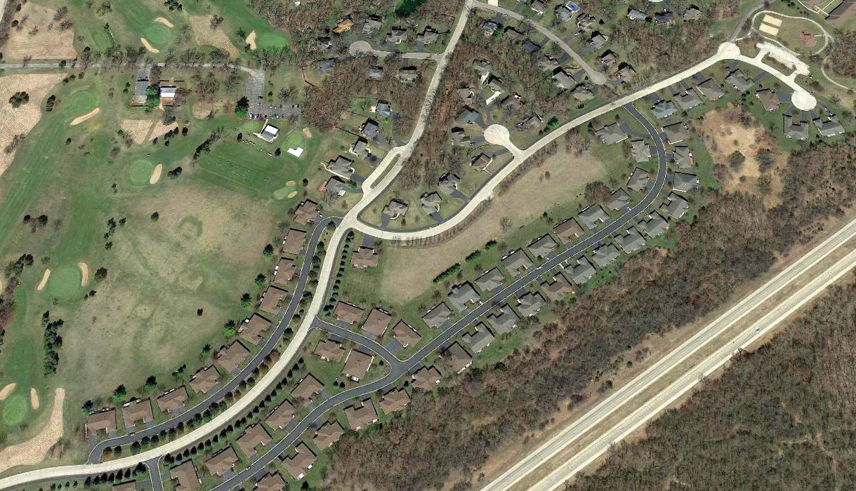
A 2019 aerial view showed houses covering the Wagon Wheel Airport site, with no trace remaining of the airport.
The site of Wagon Wheel Airport is located east of the intersection of North Main Street & Williamson Parkway.
Thanks to Erik for pointing out this airfield.
____________________________________________________
Since this site was first put on the web in 1999, its popularity has grown tremendously.
If the total quantity of material on this site is to continue to grow,
it will require ever-increasing funding to pay its expenses.
Therefore, I request financial contributions from site visitors,
to help defray the increasing costs of the site
and ensure that it continues to be available & to grow.
What would you pay for a good aviation magazine, or a good aviation book?
Please consider a donation of an equivalent amount, at the least.
This site is not supported by commercial advertising –
it is purely supported by donations.
If you enjoy the site, and would like to make a financial contribution,
you
may use a credit card via
![]() :
:
Please consider checking the box to make a monthly donatation.
For a mailing address to send a check, please contact me at: paulandterryfreeman@gmail.com
If you enjoy this web site, please support it with a financial contribution.
please contact me at: paulandterryfreeman@gmail.com
If you enjoy this web site, please support it with a financial contribution.
____________________________________________________
This site covers airfields in all 50 states.