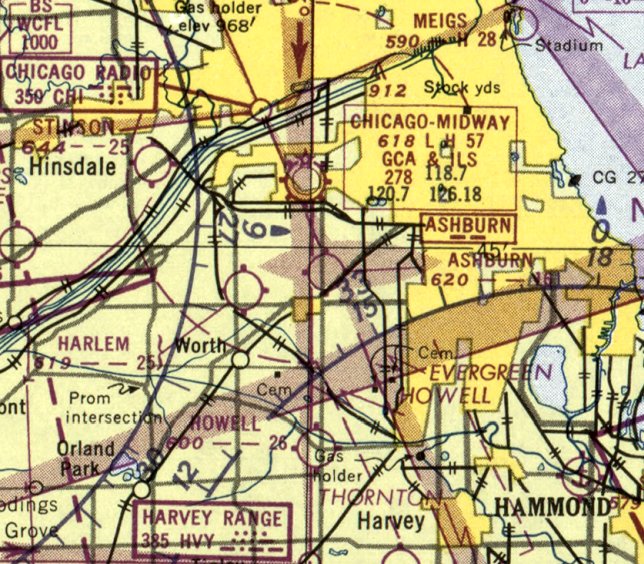
Abandoned & Little-Known Airfields:
Illinois: Western Chicago area
© 2002, © 2023 by Paul Freeman. Revised 11/25/23.
This site covers airfields in all 50 states: Click here for the site's main menu.
Please consider a financial contribution to support the continued growth & operation of this site.
Aero Club of Illinois Flying Field / Ashburn Field (revised 11/25/22) - Aurora Airport / Aurora Airways Airport / Aurora Industrial Airport (revised 1/29/21)
Harlem Airport (revised 11/29/20) - Hinsdale Airport (revised 10/6/20) - Lemont Aero Airport / Lemont Airfield (revised 2/3/21)
Lombard Airport / York Township Airport (revised 10/8/21) - Stinson Airport (revised 10/20/22)
____________________________________________________
Aurora Airport / Aurora Airways Airport / Aurora Industrial Airport, Aurora, IL
41.8, -88.337 (West of Chicago, IL)
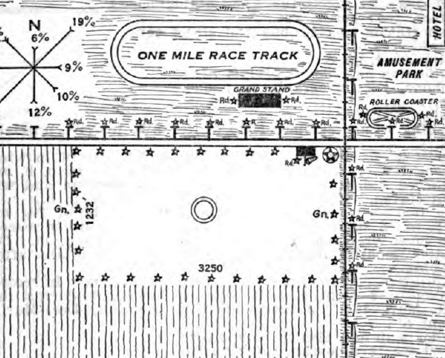
Aurora Airport, as depicted on the 4/15/29 Commerce Department Airway Bulletin (courtesy of Lee Corbin).
The date of establishment of this early airport to west of Chicago has not been determined.
The earliest depiction which has been located of Aurora Airport was on the 4/15/29 Commerce Department Airway Bulletin (courtesy of Lee Corbin).
It depicted Aurora Airport as a rectangular airfield measuring 3,250' east/west, with a hangar on the northeast side.
An oval “one mile race track” was depicted on the opposite (north) side of the street.
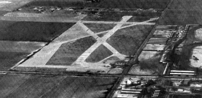
The earliest photo which has been located of Aurora Airport was a 1920s-1931 aerial view looking southwest (courtesy of Lee Corbin).
It depicted Aurora Airport as having 4 runways, with a ramp & a building on the northeast side.
The earliest aeronautical chart depiction which has been located of Aurora Airport was on the December 1930 Chicago Sectional.
A 7/7/46 USGS aerial photo depicted Aurora Airport as having 4 unpaved runways,
with 7 light aircraft parked near some buildings on the northeast side.
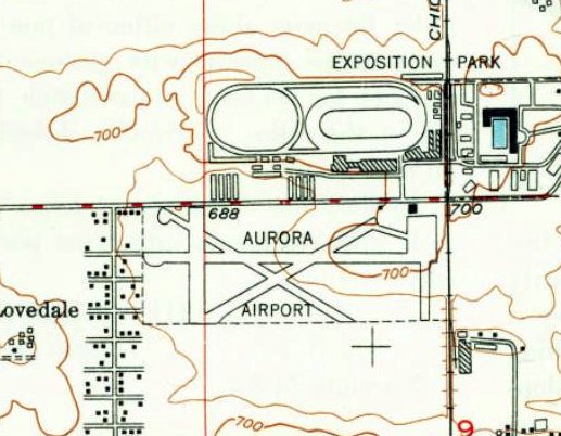
The 1950 USGS topo map (courtesy of Lee Corbin) depicted Aurora Airport as having 4 runways, with a ramp & a building on the northeast side.
A 1952 aerial photo showed a big change in Aurora Airport's runway configuration, with only 1 east/west unpaved runway.
Three light aircraft were parked near a small hangar on the northeast side.
The 1956 Chicago Local Aeronautical Chart showed Aurora Airport had gains a 2,800' paved runway at some point between 1952-56.
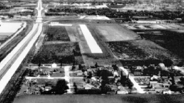
A 1961 aerial view looking east (courtesy of Lee Corbin) depicted Aurora Airport as having a single paved east/west runway, with a ramp & a building on the northeast side.
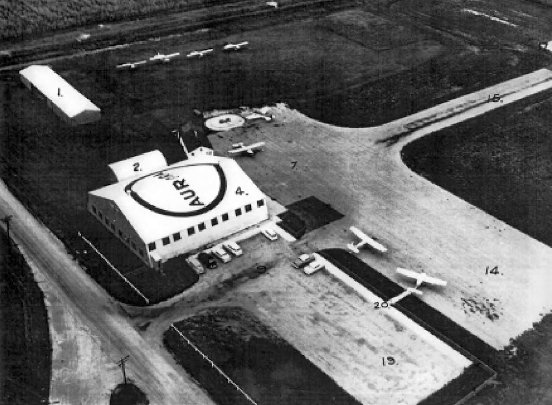
A 1960s aerial (courtesy of Lee Corbin) depicted a hangar with “Aurora” painted on the roof, and 4 light single-engine aircraft parked on the ramp.
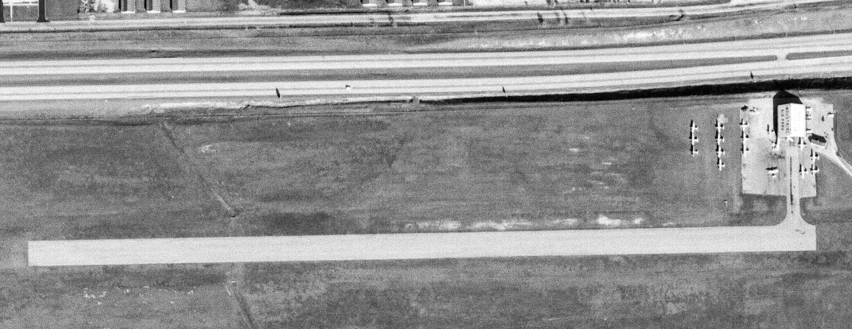
The last photo which has been located showing aircraft at Aurora Airport was an 11/14/63 USGS aerial photo.
It showed Aurora Airport at perhaps the zenith of its popularity, with 13 light aircraft parked near a small hangar on the northeast side.
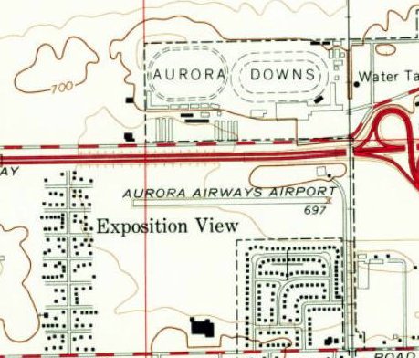
The 1964 USGS topo map (courtesy of Lee Corbin) depicted “Aurora Airways Airport” as having a single paved east/west runway, with a ramp & 1 building on the northeast side.
The 1967 Chicago Local Aeronautical Chart depicted Aurora “Industrial” Airport as having a 2,500' paved east/west runway.
A 1972 aerial photo of Aurora Airport showed a large industrial building had been built immediately adjacent to the southeast end of the runway.
The runway & small hangar on the northeast side remained intact, but there were no aircraft visible on the field.
The 1981 Chicago Local Aeronautical Chart depicted Aurora “Industrial” Airport as a private airfield having a 2,800' paved east/west runway.
Aurora Industrial Airport was evidently abandoned at some point between 1981-93,
as it was no longer depicted on the 1993 Chicago Sectional Chart (courtesy of Ron Plante).
A 1996 aerial photo showed the Aurora Airport hangar had been removed at some point between 1972-96,
but the majority of the paved east/west runway remained recognizable though deteriorated.
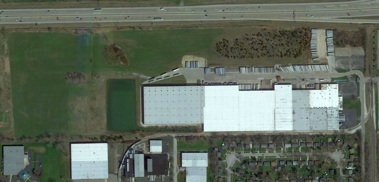
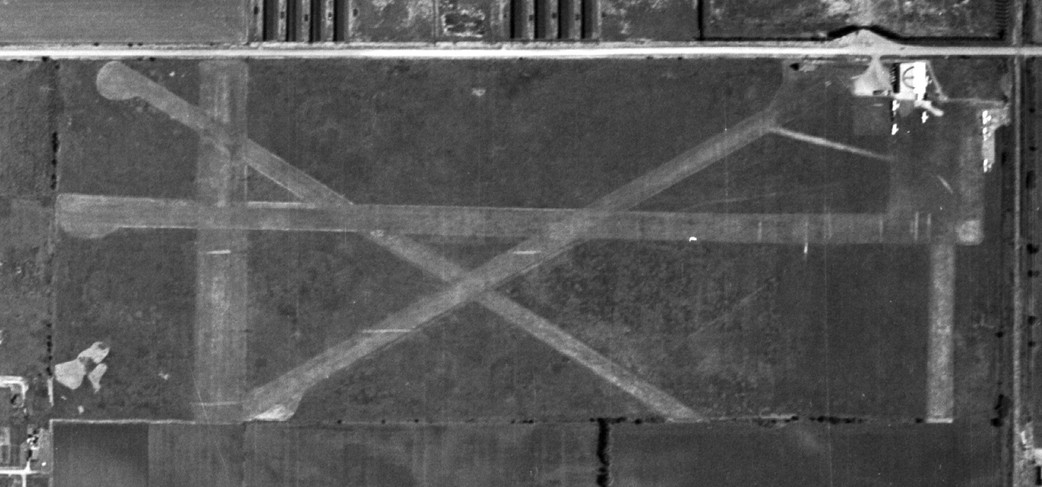
A 2017 aerial view showed 2 traces remaining of Aurora Airport: the eastern portion of the paved runway had been reused as a parking lot to the north of the warehouse,
and the former airport ramp remained on the northeast side.
The site of Aurora Airport is located west of the intersection of Evergreen Drive & Smoketree Lane.
Airport Road is located on the opposite (north) side of Interstate 88, giving a clue as to the property's history.
Thanks to Lee Corbin for pointing out this airfield.
____________________________________________________
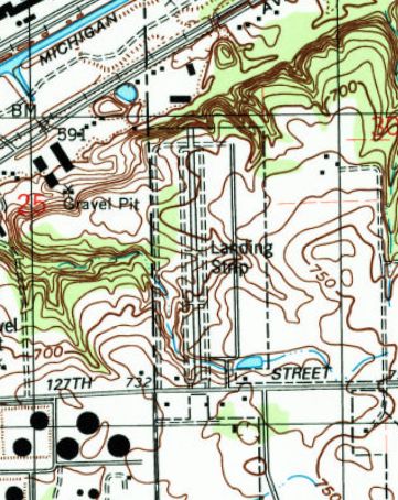
Lemont Aero Airport / Lemont Airfield, Lemont, IL
41.658, -88.027 (Southwest of Chicago, IL)
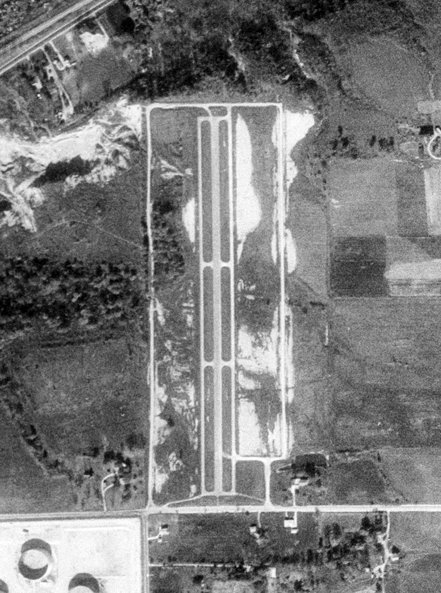
An 11/30/78 USGS aerial photo of Lemont Aero Airport.
A 1973 aerial photo did not yet show any sign of Lemont Airport, just an empty field.
According to an article entitled “Air Park Planners On Course” in the 7/24/94 Chicago Tribune by By Kristina Marlow (courtesy of Sen Kohnke),
“In the early 1970s, the owners sold 12 properties for the proposed residential air park, contingent on its final development.
But like any other property, developing an aero community depends on timing, price, amenities and location.
And in the 1970s, an air park in Lemont was an idea ahead of its time.”
"It just wasn't the right time," said Louis Dineff, a Summit attorney who was one of the owners of the property then.
Lemont Aero Airport was not yet depicted on the 1974 USGS topo map.
The earliest depiction which has been located of Lemont Airport was a 1974 aerial photo,
which apparently showed the field under construction, with a single asphalt north/south runway & a parallel taxiway on each side,
in the middle of a newly-graded rectangular property.
Lemont Airport was not depicted at all on the May 1975 Chicago Sectional Chart (courtesy of Mitchell Hymowitz).
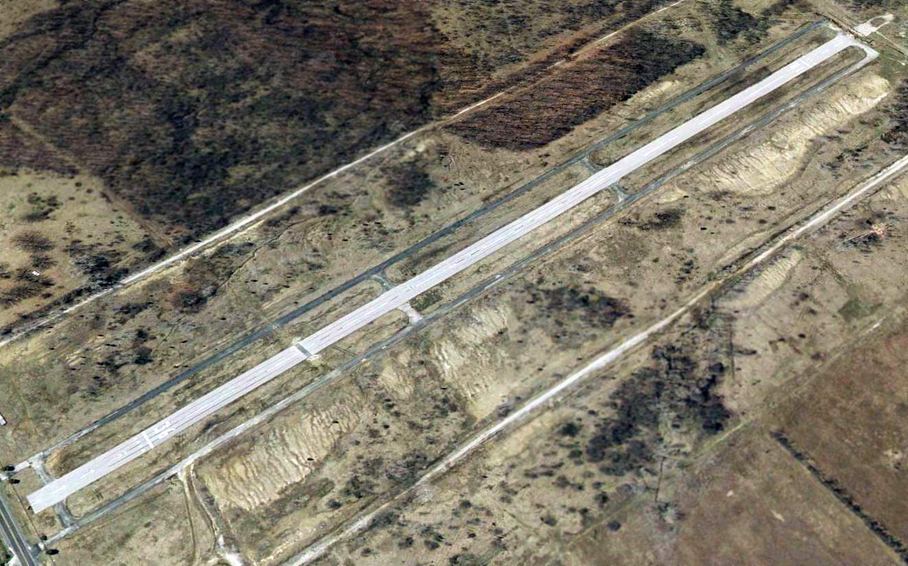
The earliest depiction which is available of Lemont Airport was an 11/30/78 USGS aerial photo.
It depicted a single north/south paved runway with a parallel taxiway on each side.
There did not appear to be any hangars or other buildings on the airport.
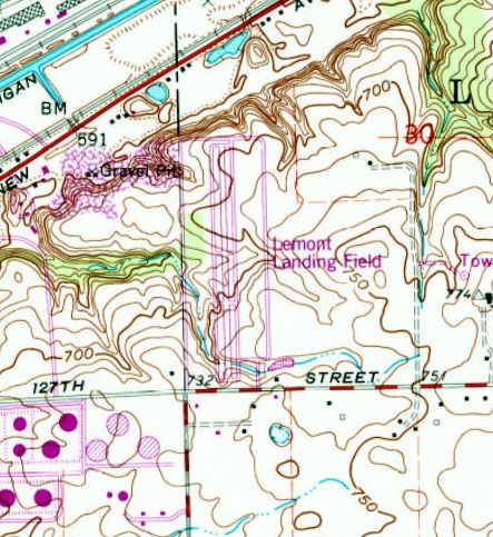
The earliest topo map depiction which has been located of Lemont Airport was on the 1980 USGS topo map.
It depicted “Lemont Landing Field” as having a single north/south paved runway with a parallel taxiway on each side.
No buildings were depicted on the airport.
Dineff & Andrew Maletich bought out the other partners & instead planned to develop a 22-plot industrial development, "the first and foremost fly-in industrial park in Chicagoland."
But the early 1980s weren't a good time for evelopment, either. So the partners put their plans on the back burner and concentrated on their own businesses.
"You just hold on to it (the property) until you have a use for it," said Dineff, who has since sold his half to his younger brother.
Eftimoff, a Willow Springs developer who is a pilot himself, had a use for it.
He wanted to combine his hobby & his home. He signed an option agreement with the new owners & started working with Lemont.
A 1988 aerial photo showed Lemont Airport in an apparently idle state.
It had a single asphalt north/south runway & a parallel taxiway on each side.
A single small building (a hangar/home?) was located on the southwest side.
A parallel road had been cleared on the east side, but without any hangars or homes, and there were no aircraft visible on the field.
In early 1992, the Village Board approved a conceptual plan for Aero Landings that included a plane maintenance area, office space,
a small strip mall & a 2-story restaurant along 127th Street, backed by single-family & town homes.
Eftimoff still hopes to expand the plan slightly, to include more residential lots.
"I think there's a market for it, especially in the metro area," said Jim Bildilli,
an engineer of airport planning & programming for the IL Division of Aeronautics, who has followed the project since its conception.
The developers of Aero Landings aren't the only ones whose dreams of a residential air park haven't immediately taken flight.
Although Eftimoff is a developer, the pilots who envision such air parks usually have little experience in development and marketing, Sclair said.
"An awful lot of people who fly love to fly, and they're not necessarily business people," he said.
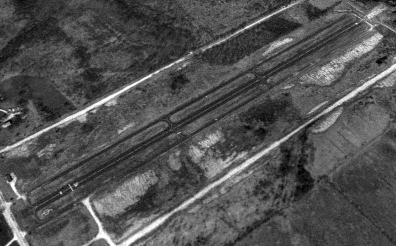
A 1993 USGS aerial view looking northwest depicted Lemont Airport as having a single asphalt Runway 18/36, with a parallel asphalt taxiway on each side.
A single small hangar was located on the southwest side.
Lemont Airport was not depicted at all on the October 1993 Chicago Sectional Chart.
The 1998 USGS topo map depicted Lemont as a single paved north/south runway, labeled simply as “Landing Strip”.
Unlike earlier depictions, the parallel taxiways were now depicted as unpaved, perhaps an indication of the airfield's deterioration.
The last photo which has been located of Lemont Airport was a 2002 aerial view looking northwest.
Runway 18/36 was still marked as an active runway, and it appeared to have been repaved compared to the asphalt parallel taxiways.
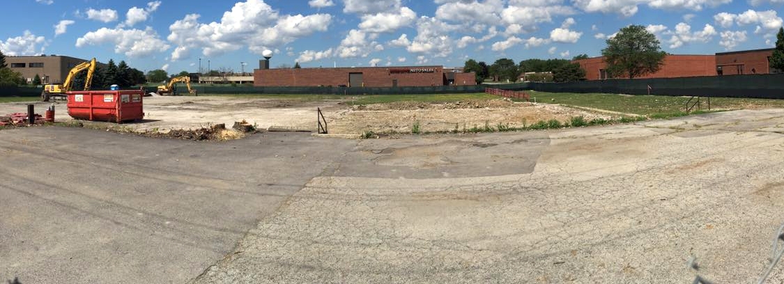
Lemont Airport was evidently abandoned at some point between 2002-2005,
as a 2005 aerial photo showed it had been swallowed by housing construction.
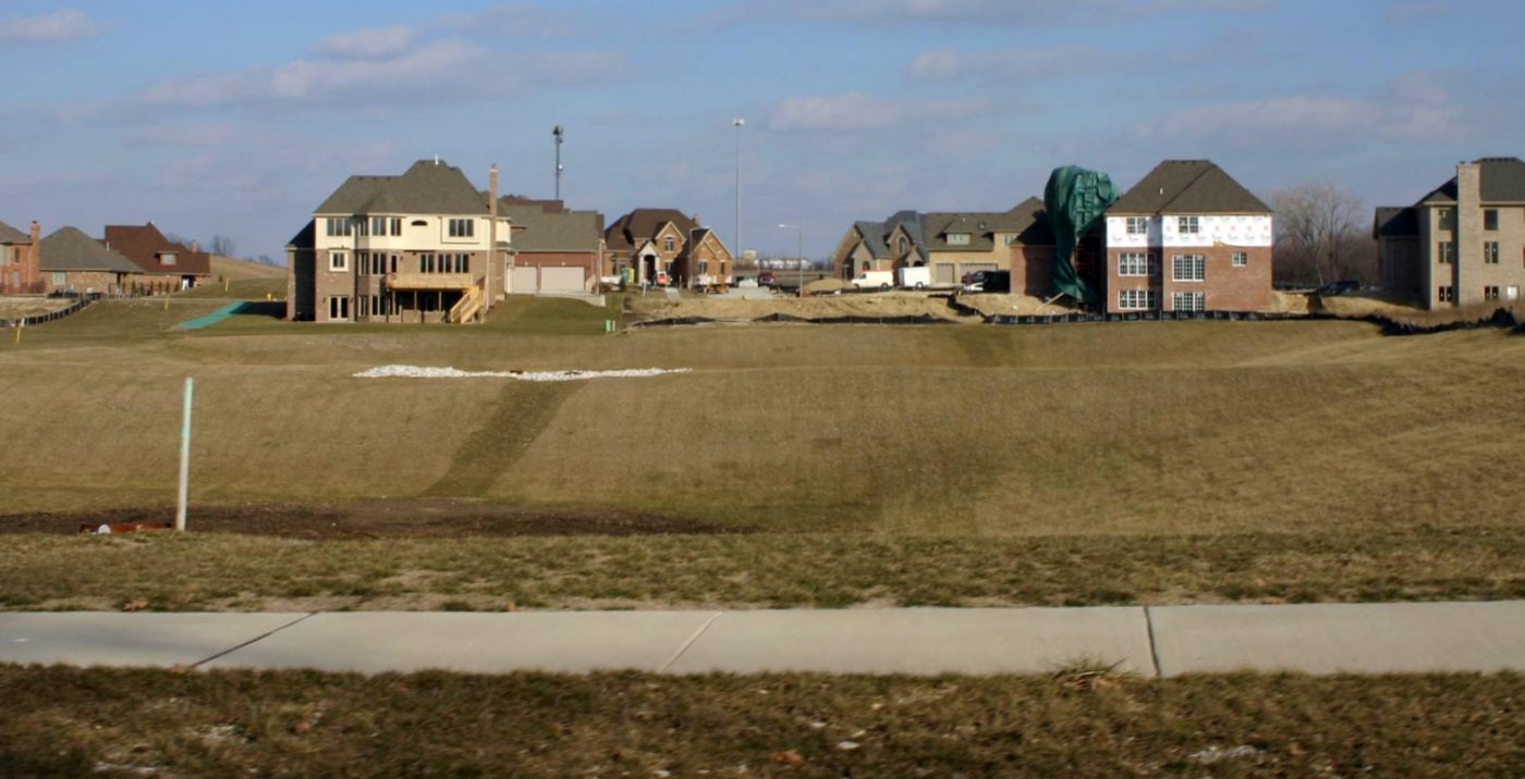
A 2006 photo looking north at the housing development built over the site of Lemont Airport.
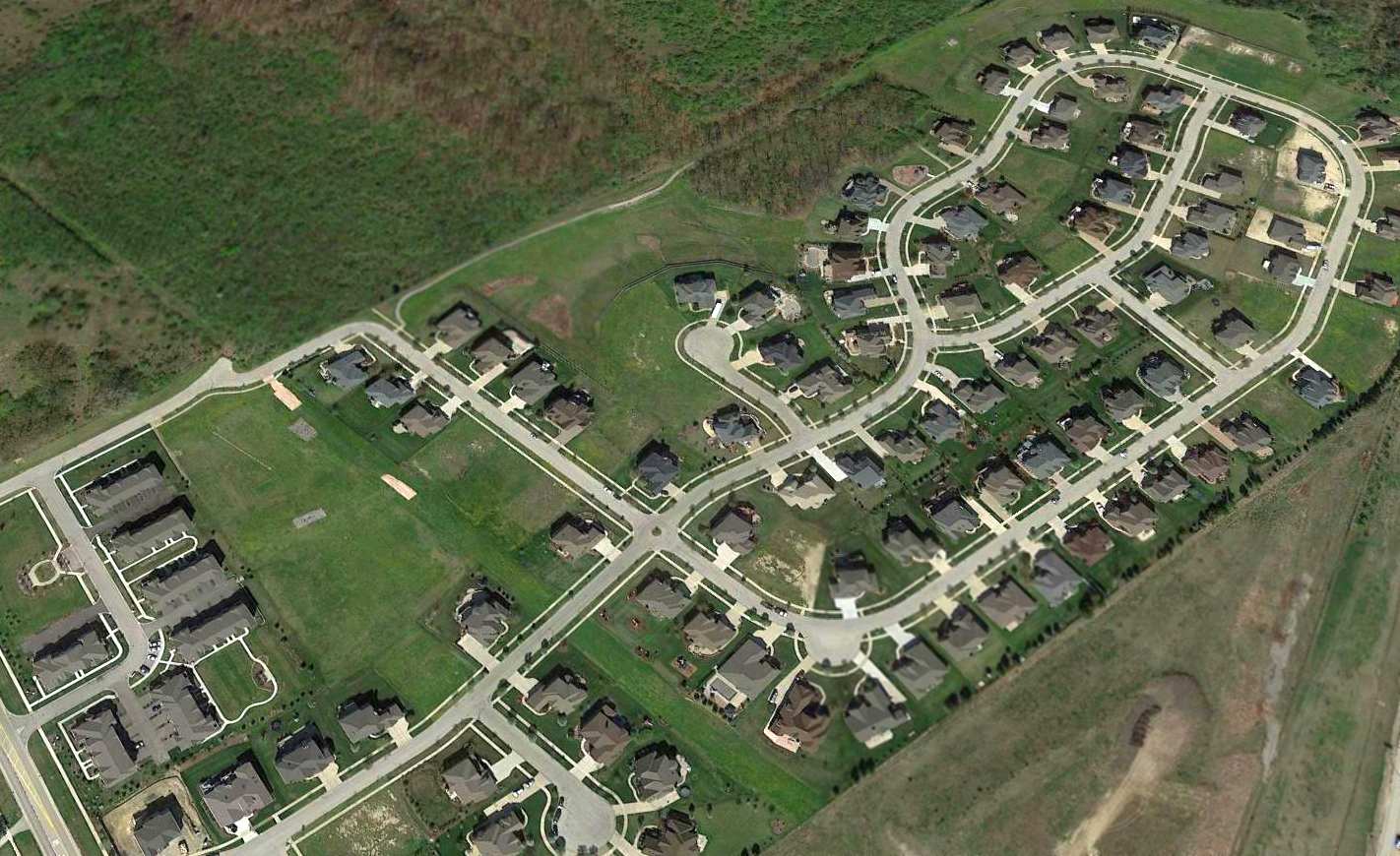
A 2015 aerial view looking northwest ay the site of Lemont Airport, with no trace remaining of the little airport.
The site of Lemont Airport is located northeast of the intersection of 127th Street & Smith Road.
Thanks to S. Williams for pointing out this airfield.
____________________________________________________
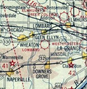
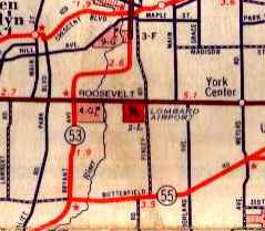
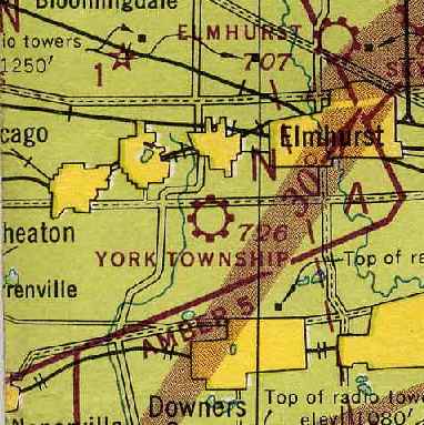
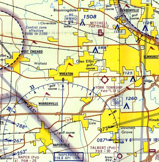
Lombard Airport / York Township Airport, Lombard, IL
41.858, -88.031 (West of Downtown Chicago, IL)
Lombard Airport, as depicted on the 1930 Chicago Sectional Chart.
According to Nicholas Selig's book “Lost Airports of Chicago”,
“In 1913, two brothers, Emile & Herbert Miller, came to DuPage County.
Their father helped them establish a Willys Knight auto repair shop on Roosevelt Road near Finley Road called the Roosevelt Garage.
In 1921, nineteen-year-old Emile became interested in aviation & assembled an airplane using an auto engine for power.”
According to Bob Siegfried, “The Miller brothers opened [Lombard Airport] on their family farm in 1920.
They operated the aviation business as the Lombard Airport Company.”
The earliest depiction which has been located of Lombard Airport was on the 1930 Chicago Sectional Chart,
which depicted Lombard as a commercial/municipal airport.
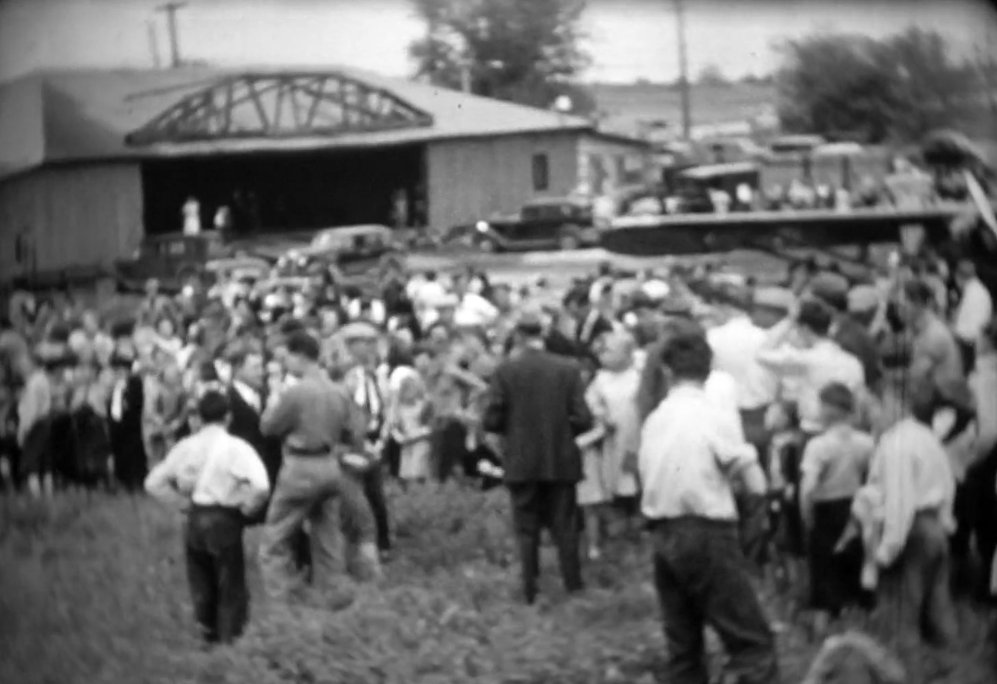
The earliest photo which has been located of Lombard Airport was a series of stills from a circa 1930s movie (courtesy of Tim Frakes).
It depicted a large crowd at the airport some kind of event, with this scene showing a high-wing monoplane in front of a hangar.
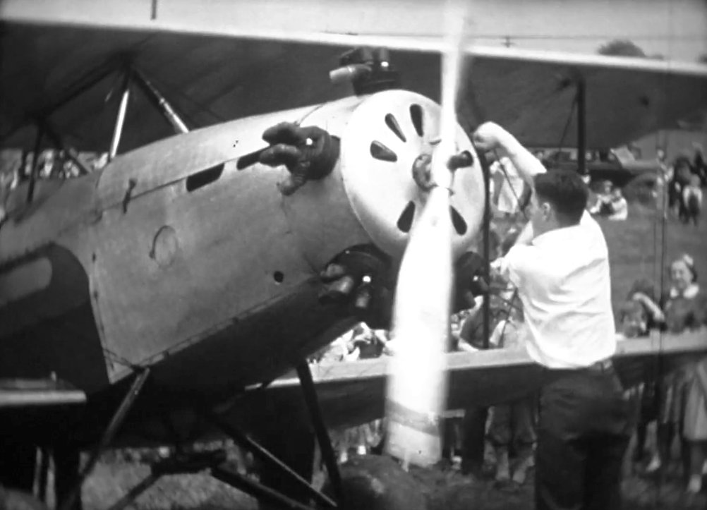
A still from a circa 1930s movie (courtesy of Tim Frakes) of a man hand-cranking a biplane at Lombard Airport.
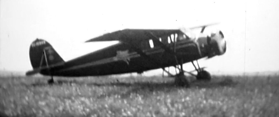
A still from a circa 1930s movie (courtesy of Tim Frakes) of a an unidentified high-wing cabin monoplane taxiing at Lombard Airport.
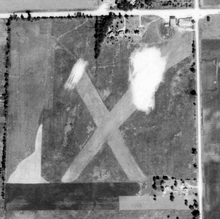
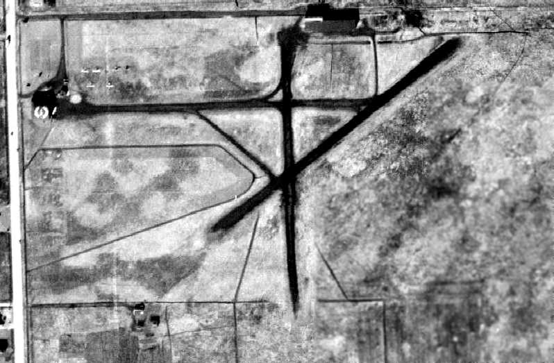
The earliest aerial photo which has been located of Lombard Airport was a 9/24/39 IL State Geological Survey aerial view.
It depicted Lombard as having 2 unpaved runways in an X-shape,
with a few small buildings on the northeast side.
Lombard Airport, as depicted on a 1941 DuPage County map (courtesy of Jim Cather).
The airport was renamed York Township Airport at some point between 1941-42,
as that is how it was depicted on the October 1942 Chicago Sectional Chart (courtesy of Brad Lawrence).
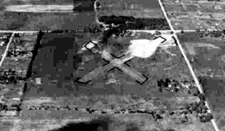
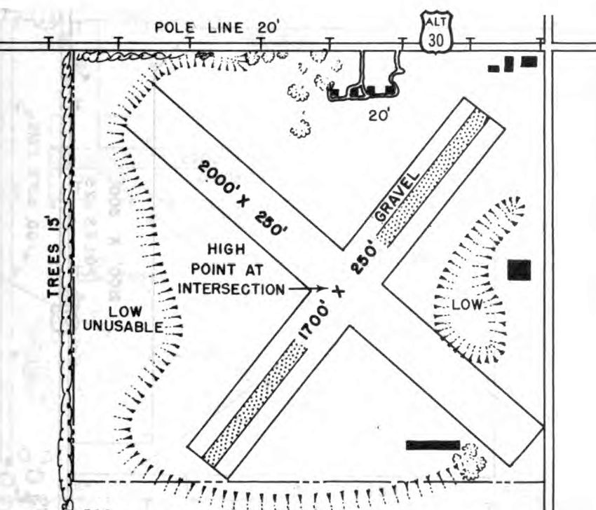
A 9/25/43 aerial view looking north from the 1945 AAF Airfield Directory (courtesy of Scott Murdock)
depicted York Township as having 2 perpendicular unpaved runways.
The 1945 AAF Airfield Directory (courtesy of Scott Murdock) described York Township
as a 61 acre rectangular property having 2 sod runways, measuring 1,800' northeast/southwest & 1,600' northwest/southeast.
The field was said to have 2 hangars, the largest being a 90' x 45' wooden building,
and to be owned & operated by private interests.
A 7/18/46 aerial view depicted York Township in much the same manner as the 1939 photo.
The 1946 Chicago Sectional Chart depicted York Township as a commercial/municipal airport.
According to Micheal McMurtrey, FAA aircraft registration records show that Cessna Bobcat NC73548
was purchased in 1947 by Lombard Airport Company Inc.
According to Nicholas Selig's book “Lost Airports of Chicago”,
“When I first laid eyes on this suburban airfield, I was a teenage Civil Air Patrol Cadet in about 1952.
Since I was the only one with access to a car, my brother's 1938 Plymouth sedan,
some of my fellow Cadets in the Maywood CAP squadron talked me into driving out to the cornfields that surrounded the airport one evening.
Our motive was the rumor that the local Lombard CAP squadron had several female Cadets, which proved to be true.”
Dave Menard recalled, “York Township / Miller Field (official name was the former, owner was the latter)...
No paved runway, and no big iron but several Cessna Bamboo Bombers, and smaller fabric-covered light planes, and some Ercoupes.
That Civil Air Patrol unit had a L-3A in CAP markings with a civil registration on it.
Eventually the L-3A was replaced by a fully USAF-marked L-16A.”
The 1953 IL Airport Directory (courtesy of Lee Corbin)
depicted York Township Airport as having 2 perpendicular unpaved runways,
with a few small buildings on the north, east, and south sides.
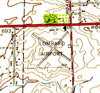
The 1954 USGS topo map continued to label the site as Lombard Airport.
It depicted Lombard as having 2 paved perpendicular runways, with several small buildings on the northeast, east, and southeast sides.
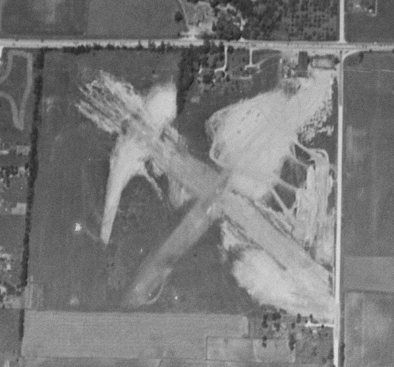
A 1961 aerial view depicted York Township as having 2 unpaved runways in an X-shape.
A hangar had been added to the east & southeast sides at some point between 1946-61.
A total of 13 light aircraft were visible on the northeast, east, and southeast sides.
According to Nicholas Selig's book “Lost Airports of Chicago”,
“When I next laid eyes on the Lombard Airport, it was about 10 years later [1962].
I flew a Piper PA-18 Super Cub into the field & took my big brother Harry for his first small airplane ride.
The area was surrounded by cornfields & still as undeveloped as it had been in 1952.
The most significant thing about it was that the middle of the field where the 2 sod & gravel runways crossed
was about 10' higher than the corners of the field.
Therefore it wasn't uncommon when starting a takeoff in one direction to find an aircraft coming at you from the other end over the hill.
However, side from a few startling near-happenings I never heard of any collisions occurring.”
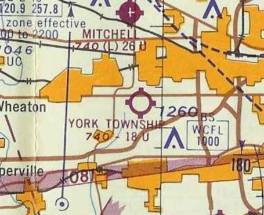
The 1962 Chicago Sectional Chart depicted York Township Airport as having an 1,800' unpaved runway.
Mike Crist recalled, “Lombard... Dad took a few flying lessons there in the 1960s.
We would wait for him, parked in our car along Roosevelt Road.
There was a big hangar along Roosevelt with the opening facing south.
It had a red painted checkerboard pattern design on it & it was beige/brown.
We would park to the east of the hangar, where a taxiway along Finley Road was where all the airplanes parked.
There was a runway running roughly northeast/southwest.
I remember Dad revving up the plane engine & off he would go.
There was more storage & parking along the west side of the hangar.”
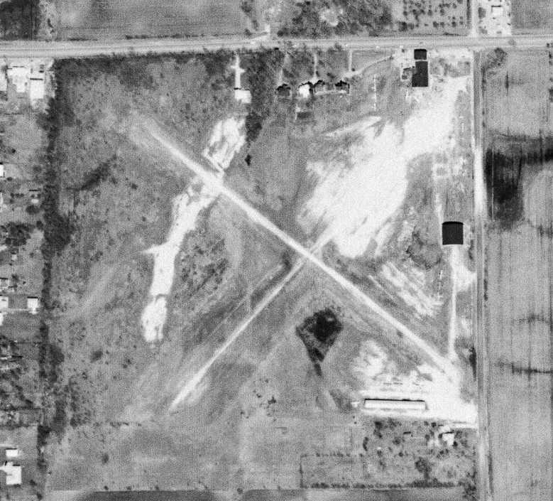
The last photo which has been located of York Township Airport was a 4/10/62 aerial photo.
The airport appeared to be well-used, with a total of 14 light aircraft visible on the northeast, east, and southeast sides.
Frank Ziberna recalled, “York Airport at the southwest corner of Roosevelt Road & Finley... we kept our airplane there.
There is a big apartment building now where we used to tie down & a bank where the hanger was.
We were there one time in the mid-1960s to pay our tie down fees & there was an old guy hanging around the hangar.
It was your typical airport office. Junk all over & the old couch in the office.
It turns out the guy in the office used to fly airmail out of Checkboard field with Lindberg.
They also jumped parachutes together. He was a fascinating person to listen to.
They did an interview with him the next year on one of the local TV stations.
It was funny he was just hanging around the airport looking for people to talk to.
I remember my dad telling me on the way home that I should remember this because it had been a rare opportunity.”
The last aeronautical chart depiction which has been located of York Township Airport was on the 1967 Chicago Local Aeronautical Chart (courtesy of Tim Zukas).
It depicted York Township as having a mere 1,800' unpaved runway.
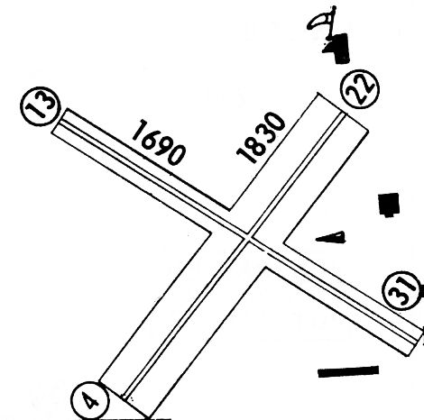
The last airport directory listing which has been located of York Township Airport was in the 1968 Flight Guide (courtesy of Robert Levittan).
It depicted York Township Airport as having 2 perpendicular runways, 1,830' Runway 4/22 & 1,690' Runway 13/31.
The 1970 USGS topo map still depicted Lombard Airport.
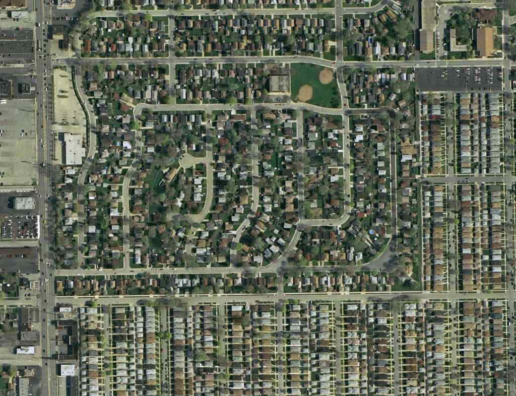
Lombard Airport was eventually closed & built-over by apartments.
Mike Crist recalled, “There was one lone plane that supposedly belonged to a doctor, parked west of the hangar long after everything else was gone.”
Dave Strieter recalled, “The apartment complex was, and still is, called International Village Apartments.
I lived in that very new complex from June 1971 - May 1973, so it is clear that the airport must have closed no later than 1970.
I remember that in June 1971, a dilapidated, abandoned wooden hangar still stood on the corner & I walked over to look at it up close.
The hangar was demolished shortly after that. The MEMCO & a restaurant were built on the hangar site while I still lived in the apartments (prior to May 1973).”
York Township Airport was was no longer depicted on the May 1973 Chicago Terminal Aeronautical Chart (courtesy of Mitchell Hymowitz),
and the 1973 USGS topo map depicted apartment buildings covering the site.
A 1974 aerial view showed apartments & other buildings covering the site,
with no trace remaining of the little airport.
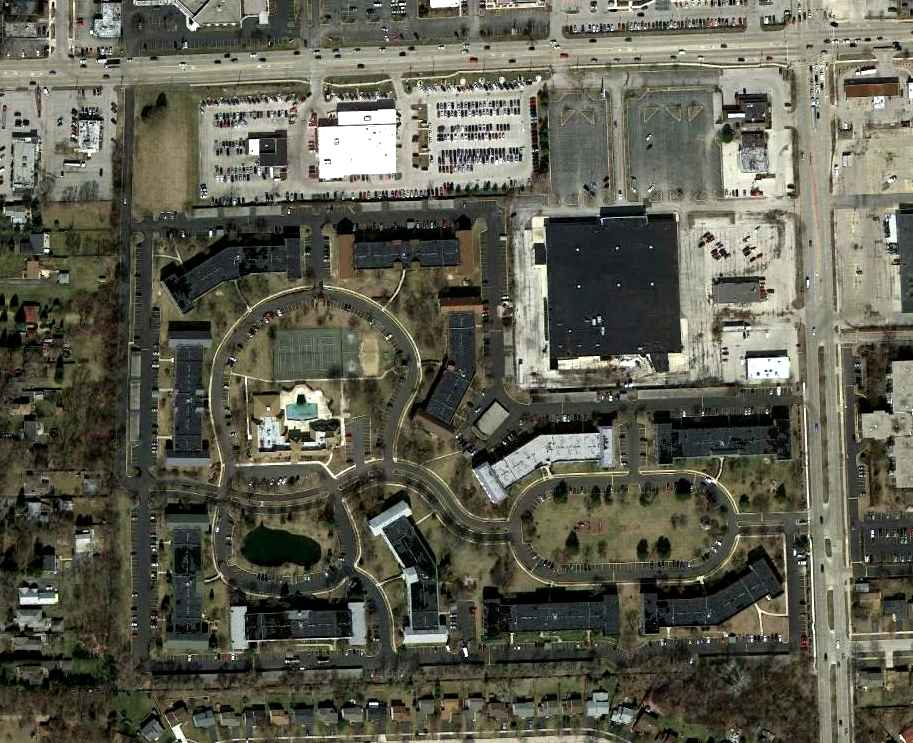
A 3/12/12 aerial view showed no trace remaining of York Township Airport.
The site of York Township Airport is located southwest of the intersection of Roosevelt Road & Finley Road.
____________________________________________________
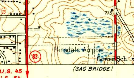
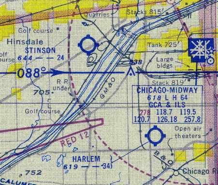
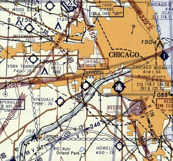
Hinsdale Airport, Hinsdale, IL
41.748, -87.94 (West of Chicago Midway Airport, IL)
A 1939 aerial photo of Hinsdale Airport (from the Access IL Historical Aerial Photography collection, via Chris Kennedy).
This general aviation airport was evidently established at some point between 1937-39,
as it was not yet listed among active airfields in The Airport Directory Company's 1937 Airports Directory (courtesy of Bob Rambo).
The earliest depiction which has been located of the Hinsdale Airport
was a 1939 aerial photo (from the Access IL Historical Aerial Photography collection, via Chris Kennedy).
It depicted Hinsdale as having 2 grass runways, oriented north/south & northeast/southwest.
A set of buildings (hangars?) sat south of the runway intersection.
According to Linda Lyman, her brother John Lyman had a Taylorcraft at Hinsdale Airport.
Linda recalled, “He had a Taylorcraft Model A which he bought from Charlie Feris in 1939.
At age 10, I was following my brother around the Hinsdale Airport.”
The earliest aeronautical chart depiction which has been located of the Hinsdale Airport
was on the May 1942 Chicago Sectional Chart (courtesy of Chris Kennedy).
It depicted Hinsdale as a commercial/municipal airfield.
The April 1944 US Army/Navy Directory of Airfields (courtesy of Ken Mercer)
described Hinsdale as having a 2,600' unpaved runway,
along with the remark, “Rolling ground, caution.”
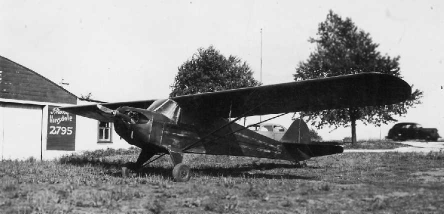
An 8/5/44 photo of John Lyman's Taylorcraft Model A NC19047 at Hinsdale Airport (courtesy of Linda Lyman),
with a hangar visible in the background.
The October 1944 Chicago Sectional Chart (courtesy of Richard Doehring)
depicted Hinsdale as a commercial/municipal airfield.
Hinsdale Airport, as depicted on a 1947 street atlas.
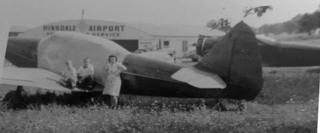
A September 1948 photo of Anna, Max and Henry Ocic of a Fairchild M-62A (a civilianized 1940 Fairchild PT-19) at Hinsdale Airport (courtesy of Danni Halik),
with a Hinsdale Airport hangar visible in the background.
The 1953 USGS topo map depicted Hinsdale Airport as having 2 perpendicual unpaved runways.

The 1953 IL Airport Directory (from the University of IL, courtesy of Daniel McGill) depicted Hinsdale Airport as having 2 perpendicual runways,
measuring 2,600' east/west & 2,400' north/south.
A single small building was depicted on the southeast side.
The 1956 Chicago Local Aeronautical Chart depicted Hinsdale Airport as having a 2,600' unpaved runway.
According to Bob Morrison, “In the late 1950s & early 1960s
Will St. Germain bought the airport & started a flight school there.
My father Lawrence 'Dutch' Morrison was one of the flight instructors there, and I grew up there as an airport brat.
My first real job was line boy. In the 1960s the hangar that Midwest now occupies was built as a repair hangar for St. Germain.
At one time they were the largest Piper distributor in the region.
When my father became airport manager I would fly with him on lunch hours & that's how I got my ticket.
I built taxiways, hauled gravel & graded it for 2 whole summers.”
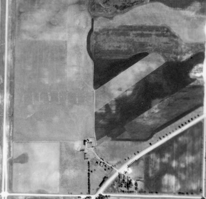
A 1961 aerial photo depicted as having 2 paved runways,
and 4 hangars, all of which had been added at some point between 1939-61.
Dozens of light aircraft were parked on the southeast side of the field.
A 1962 photo depicted the field in the same manner.
A passenger-freight charter air service called Altra-Aire Aviation Enterprises Inc. operated from Hinsdale Airport from 1962-64.
The 1962 IL Airport Directory (courtesy of Jonathan Westerling) depicted Hinsdale as having 2 paved runways: 2,160' east/west & 1,800' north/south.
Midwest Helicopter Airways started operations in Hinsdale in June 1968
as a FAR 133 certified external load company with one Sikorsky S-55 helicopter.
They presumably operated from Hinsdale Airport.
The 1969 Chicago Sectional Chart depicted Hinsdale Airport as having 2 paved runways, with the longest being 3,200'.
The 3,200' Runway 4/22 was evidently added at some point between 1962-69.
The 1971 Flight Guide (courtesy of Chris Kennedy) depicted Hinsdale Airport
as having 2 paved runways (3,200' Runway 4/22 & 2,450' Runway 10/28), along with a closed north/south runway.
A number of hangars were clustered on the south & east sides of the field.
The May 1971 Chicago Sectional Chart (courtesy of Chris Kennedy)
depicted Hinsdale Airport as having 2 paved runways, with the longest being 3,200'.
According to Bob Morrison, “In 1971 Will St. Germain [Hinsdale Airport owner]
came down with cancer from which he never recovered.
His wife Wilma wanted to sell the property as it was very valuable even back in those days.
So my father stayed & managed the airport until the sale was final & retired to Florida in 1973.
An awful lot of my boyhood memories involve that great old airport.”
David Bossert recalled, “I grew up in Hinsdale, and remember the airport well.
A childhood friend's father was a TWA pilot, who kept a Cessna at Hinsdale.
My first flight in a small plane was there. I remember him pointing out that the runway elevation was highest in the center.
When you were at one end of the runway, you could not see the other end!”
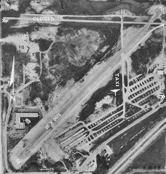
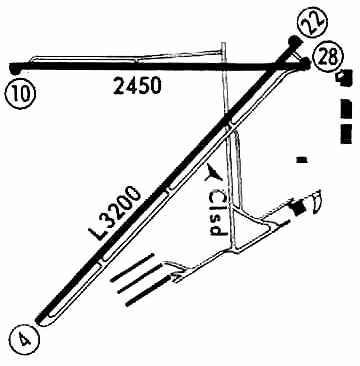
An aerial view of Hinsdale Airport from the 1972 IL Airport Directory (courtesy of Bill Pagett).
The directory depicted the field as having a single 3,200' blacktop Runway 4/22, along with a closed east/west runway.
An extensive parking area on the southeast side of the field held dozens of aircraft.
The operators were listed as Widwest & Hinsdale Aviation, St. Germain Aviation Co., and Douglas Aircraft Service.
The airport manager was listed as Larry Staples.
According to Raymond Skoff, “If you look at the aerial view from the 1972 Airport Directory,
I heard (but have not verified) that the hangar on the east side of the airfield immediately west of the windsock was originally a Taylorcraft distributorship.
I recall as a kid riding my bike over to this hangar & seeing a row of old Taylorcrafts parked along the fence line.
When the airfield shut down, my cousin & I snuck out to the hangar one evening & took the windsock.
I gave the windsock frame to a guy who operated an airport in Alaska,
and I've still got part of the Shell windsock in my garage.”
The last aeronautical chart depiction which has been located of Hinsdale as an active airfield
was on the May 1973 Chicago Terminal Aeronautical Chart (courtesy of Mitchell Hymowitz).
It depicted Hinsdale Airport as having 2 paved runways, with the longest being 3,200'.
David continued, “About 1973, I saw the bulldozers & graders turning that wonderful place into a sea of dirt.
The only building left standing was in the southeast corner of the field.
Its a medium sized hangar with office space, now owned by Midwest Helicopter.”
According to Raymond Skoff, “The hangar occupied by Midwest Helicopter Airways was originally a Piper hangar.
I believe Midwest took the hangar from Piper as the airfield was shut down.”
A 1974 aerial view showed the site after Hinsdale Airport had been closed.
The runways were still intact, but all of the hangars had been removed, with the exception of one hangar on the east side.
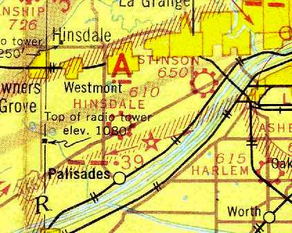
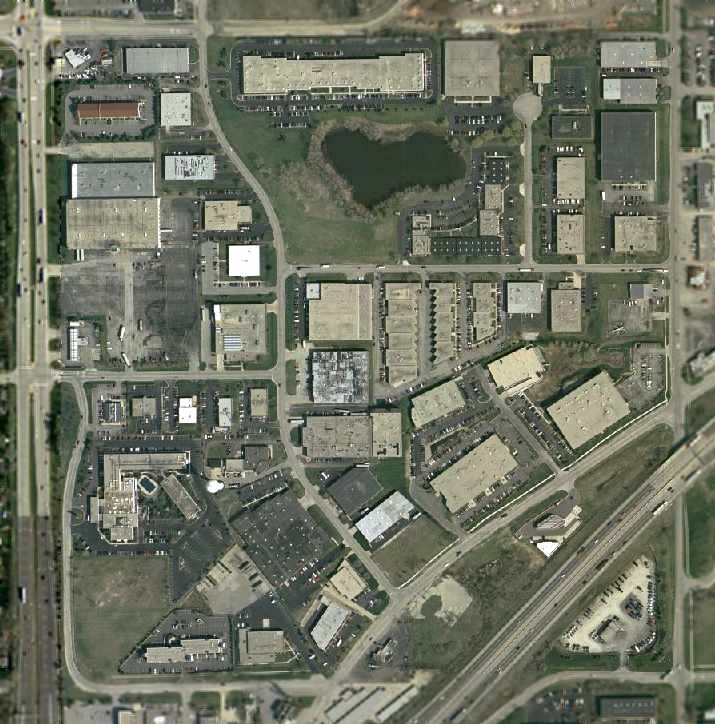
In 1975, the Willowbrook Executive Plaza, a 105-acre industrial park, was built on the site of Hinsdale Airport.
Hinsdale Airport was depicted as an abandoned airfield on the November 1976 Chicago Sectional Chart (courtesy of Chris Kennedy).
David Bossert recalled, “In 1977, I stuck my head in Midwest Helicopter, but they were too busy for a wide-eyed teen.
They had a Sikorsky S-55 & an S-58 (Army surplus) both white with a red stripe.
Sad it disappeared, but at least a fraction survived.”
The 1978 USGS topo map no longer depicted the former Hinsdale Airport.
A 1988 aerial view showed that buildings & streets had covered the former Hinsdale Airport.
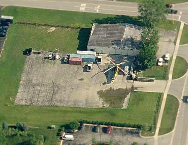
A 2002 USGS aerial photo of the site of Hinsdale Airport.
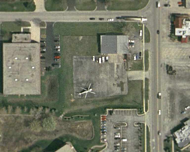
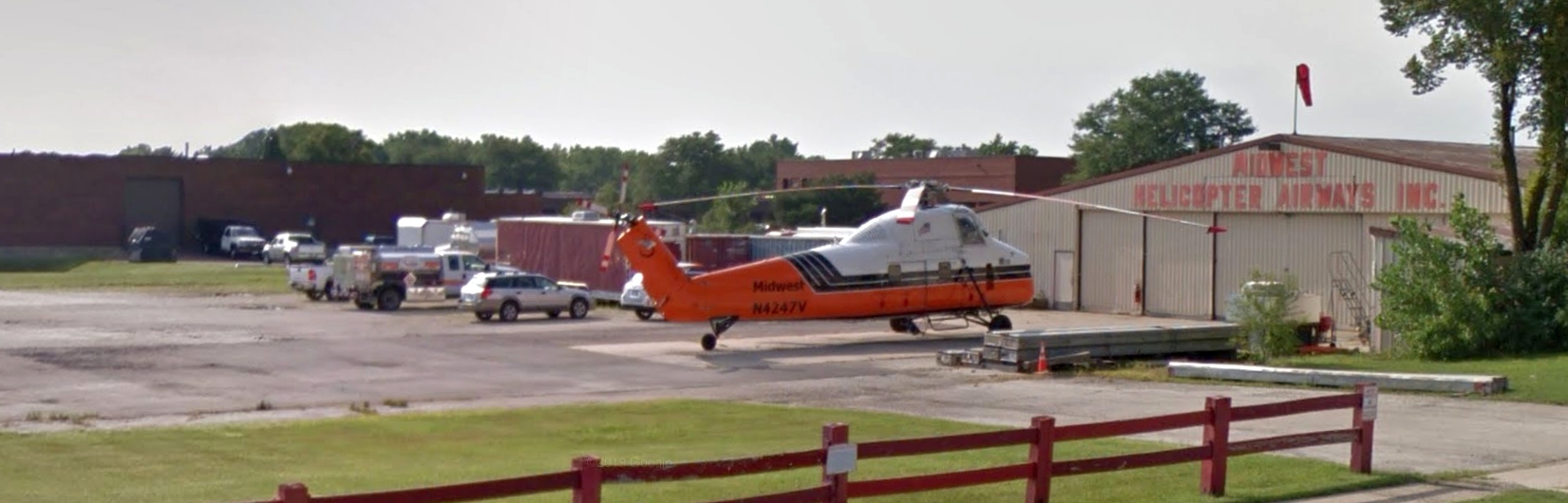
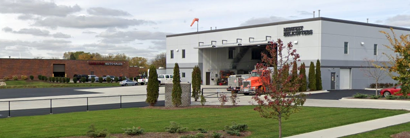
A close-up from the 2002 USGS aerial photo, showing a single S-58T helicopter at the Midwest Heliport,
which occupies a portion of the site of Hinsdale Airport, along with the only remaining hangar.
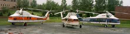
A circa 2000s photo of Midwest Helicopter Airways' 3 S-58Ts.
As of 2005, the site of Hinsdale Airport still retained an aviation use,
as it was the site of the Midwest Heliport, a private facility which served as the base of Midwest Helicopter Airways.
They operated a fleet of 3 Sikorsky S-58T heavy-lift helicopters.
A circa 2006 aerial view looking north at the hangar of Midwest Helicopter Airways,
with an MD-500 on the left side of the ramp & a S-58T on the right.
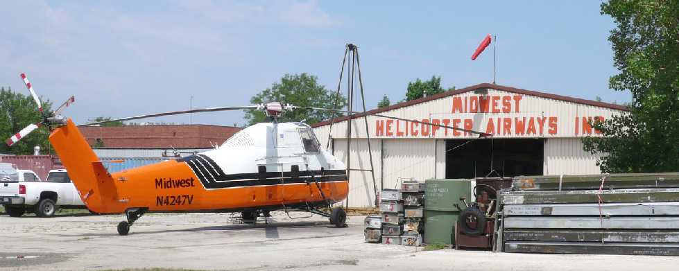
A 7/18/12 photo looking northwest at a Midwest Helicopter Airways S-58T in front of their hangar at the site of Hinsdale Airport.
Jim Triggs reported, “Our operation is the last that remains of the Hinsdale Airport, and we occupied the old Saint Germaine hangar.
Midwest has been in operation for nearly 50 years, and has occupied the hangar at the old Hinsdale Airport for the majority of that time.”
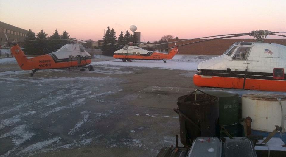
A circa 2012-2013 photo of 3 Midwest Helicopter Airways Sikorsky S-58Ts in front of their hangar at the site of Hinsdale Airport.
Jim Trigg recalled, “It has only happened a handful of times where all 3 of our aircraft are at the home base at the same time, and typically it is only for a day or so before one leaves.
Putting the helicopter in the hangar was a shoehorn fit, one of the reasons for the new facility.
The old facility flooded numerous times as it became the low spot in town.”
The last photo which has been located of a helicopter at Midwest Helicopter Airways' hangar at the site of Hinsdale Airport was an August 2016 photo looking northwest showing one of their S-58Ts.
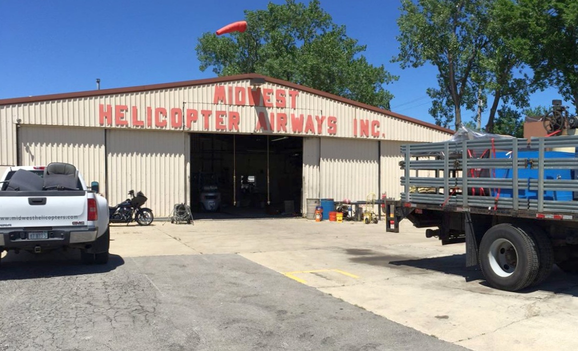
A June 2017 photo of the Midwest Helicopter Airways hangar at the site of Hinsdale Airport (courtesy of Jim Triggs), shortly before its demolition.
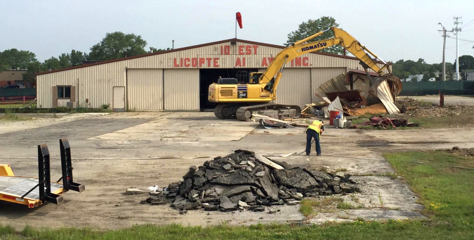
A June 2017 photo of the Midwest Helicopter Airways hangar at the site of Hinsdale Airport (courtesy of Jim Triggs), at the start of its demolition.
Jim Triggs reported, “As of last week, the last remaining portion of the airport was torn down.
We have made the hard decision to demolish the old hangar to rebuild a new facility, one that will allow us to continue to operate at the capacity we operate at.
We are temporarily located at Clow Airport in Bolingbrook, IL until early 2018 when the new facility is slated to be complete.
The new hangar will be built in the exact location as the old one, but much larger.
So while the last reminisce of the airport is now gone, aviation will continue in that location for years to come.”
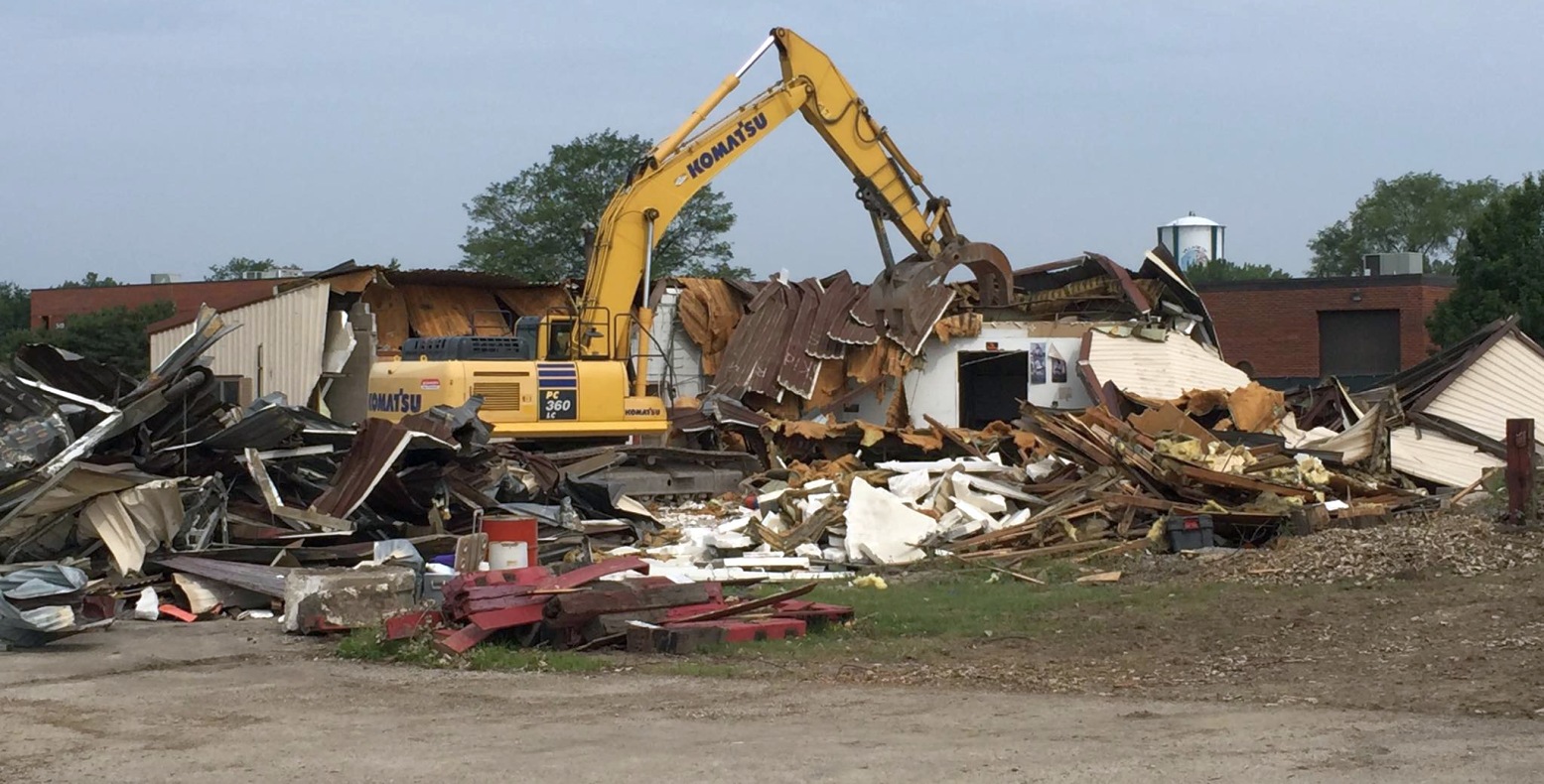
A June 2017 photo of the demolition of the Midwest Helicopter Airways hangar at the site of Hinsdale Airport (courtesy of Jim Triggs).
A June 2017 photo of the site of the Midwest Helicopter Airways hangar at the site of Hinsdale Airport (courtesy of Jim Triggs), after its demolition.
A September 2017 photo of the site of the Midwest Helicopter Airways hangar showed the site remained clear after its demolition.
Keeping alive the aviation role at the site of Hinsdale Airport, an October 2019 photo looking northwest (courtesy of Benton Bullwinkel)
shows the replacement hangar & helipad which Midwest Helicopter Airways built at the site.
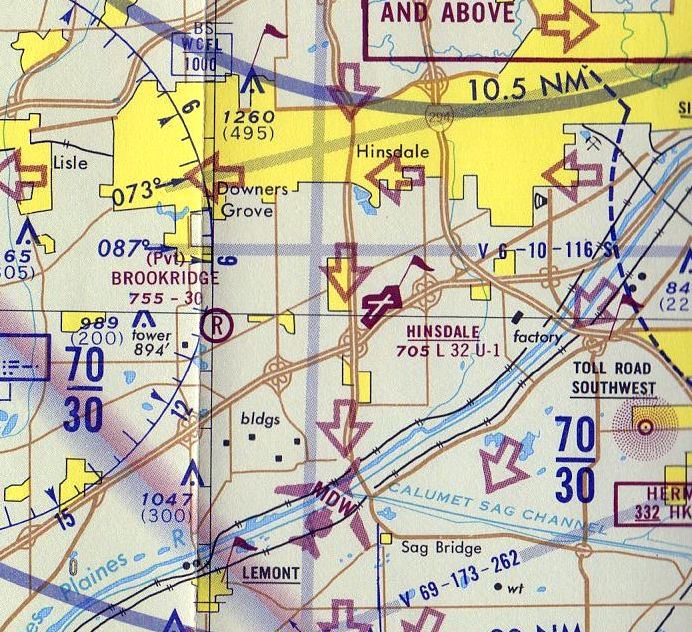
The site of Hinsdale Airport is located northeast of the intersection of Interstate 55 & South Madison Street.
Thanks to Benton Bullwinkel for pointing out this airport.
____________________________________________________
Aero Club of Illinois Flying Field / Ashburn Field, Chicago, IL
41.74, -87.736 (South of Chicago Midway Airport, IL)
 '
'
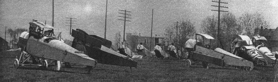
A circa 1917-18 photo of 9 partially-assembled biplanes, originally captioned “The Government Aviation Training Camp at Ashburn IL” (from the NY Times, courtesy of Glenn Ragaishis).
According to Len Kmiecek, the Aero Club of IL was originally located at Cicero Field
at approximately at 22nd Avenue & Cicero Avenue from late 1911 until the end of 1913.
It closed in early 1914, and most users moved to newly opened (1914) Aero Club of IL, at 83rd Street & Cicero Avenue.
Len Kmiecek recalled, “Tommy [airport manager Gordon Thomas] told me that Ashburn was the first 'registered' airport in IL.”
The earliest depiction which has been located of Ashburn Airport was a circa 1917-18 photo of 9 partially-assembled biplanes,
originally captioned “The Government Aviation Training Camp at Ashburn IL” (from the NY Times, courtesy of Glenn Ragaishis).
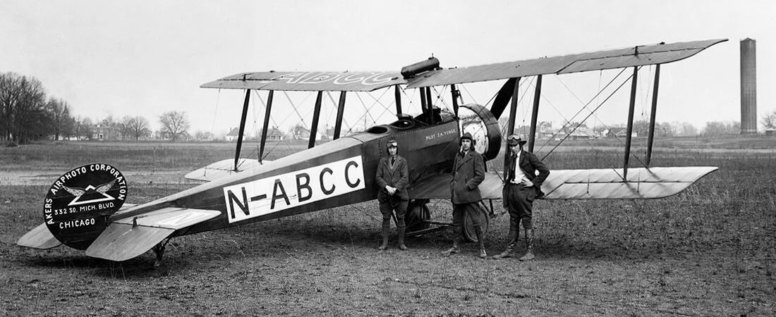
A November 1921 photo of Akers Airphoto Corporation Avro 504K N-ABCC at Ashburn Airport.
In the early 1920s there was little regulation of American commercial aviation, and one result was a difficulty of obtaining aircraft insurance.
The N-letter register was set up not by the government but by Underwriters' Laboratories. Less than 50 aircraft were entered in this voluntary register, with N-ABCC being one of the first.
John Yonge, on the right, became the 9th pilot registered by Underwriters Laboratory.
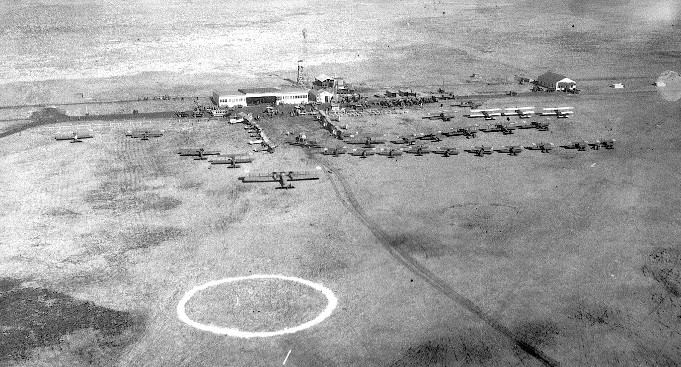
A circa 1921-23 aerial view (courtesy of Glenn Ragaishis) depicted Ashburn Airport as having a hangar, several smaller buildings, and beacon tower on the side of an unpaved airfield,
next to which was parked a total of 40 civilian & military biplanes.
Glenn Ragaishis remarked, “The circle was probably for parachute training or parachute target for aerial shows.”
Glenn Ragaishis reported, “A young Charles Lindbergh hung around a bit at Ashburn.
The field was originally owned by Pops Dickinson.
It is purported that WC Fields once used that airfield & the first airmail service to Chicago ran through here.”
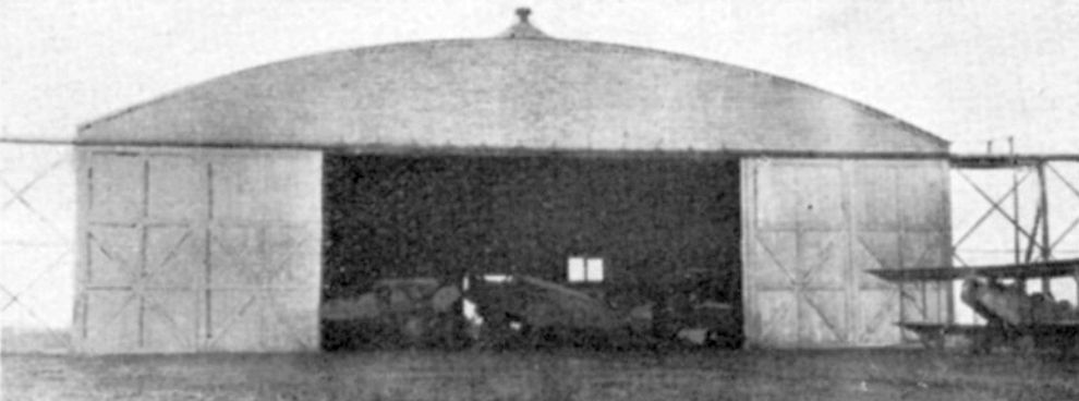
An undated photo of a hangar at the Aero Club Airport from a circa 1923 prospectus of “The Partridge System of Aeronautical Instruction” from the Aero Club of IL Field (courtesy of Tom Hietzman).
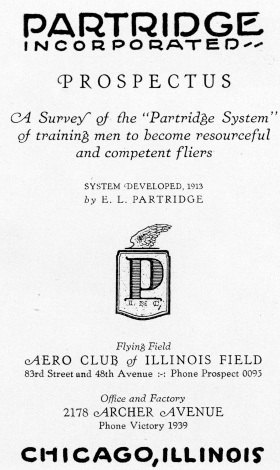
A circa 1923 prospectus of “The Partridge System of Aeronautical Instruction” from the Aero Club of IL Field (courtesy of Tom Hietzman).
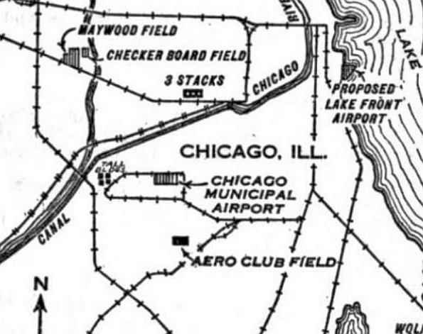
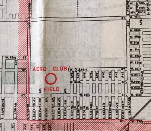
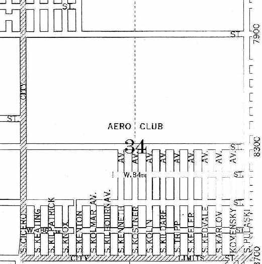
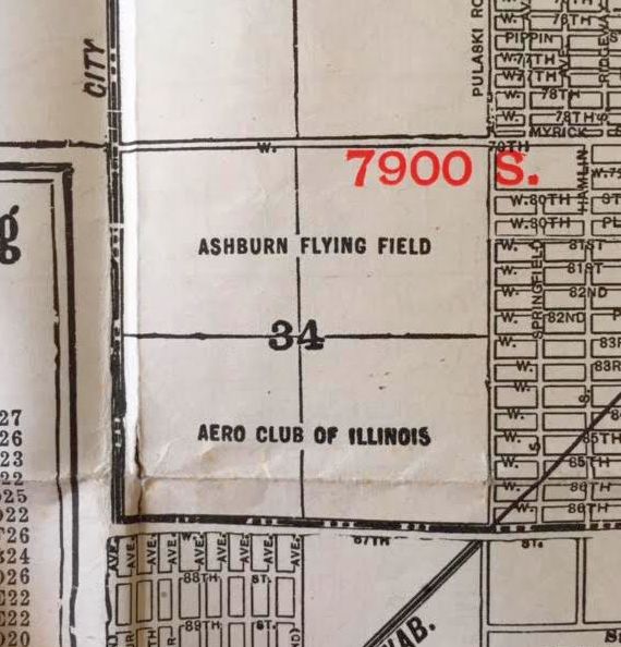
Location of the “Aero Club Field”, as depicted on the 6/29/28 Commerce Department Airway Bulletin (courtesy of Mike Denja).
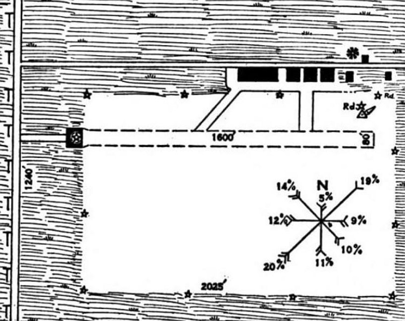
The 6/29/28 Commerce Department Airway Bulletin (courtesy of Mike Denja) depicted the Aero Club of Illinois airfield
as a 67 acre rectangular sod field having a 1,600' east/west ruunway, with 6 buildings along the northeast side, one of which was said to be marked with “Aero Club of Illinois” on its side.
It was owned by the Aero Club of Illinois, and operated by the Aero Club of Illinois & the Commerce Department.
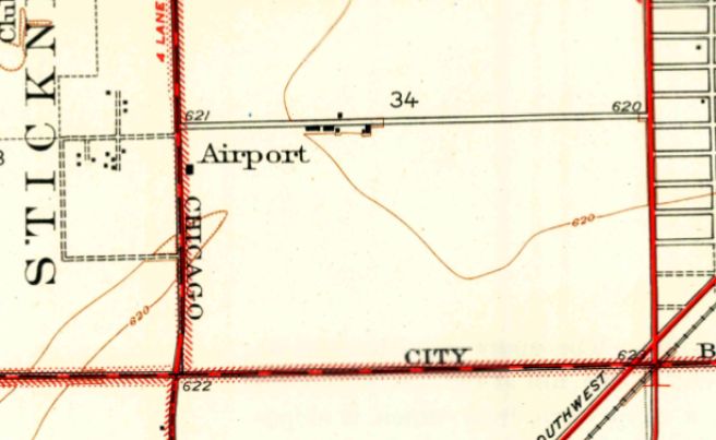
The earliest topo map depiction which has been located of the Aero Club Airport was on the 1929 USGS topo map, which labeled it simply as “Airport”.
It depicted an empty field with several buildings along the west & north sides.
The earliest aeronautical chart depiction which has been located of the Aero Club Airport was on the 1930 Chicago Sectional Chart.
The Airport Directory Company's 1933 Airports Directory (courtesy of Chris Kennedy)
described the Aero Club as a commercial airport, consisting of a 67 acre rectangular field.
The field was said to have 2 sod runways, with the longest being the 1,600' east/west strip.
A hangar was said to have "Aero Club of Illinois" painted on its side.
“Aero Club Field”, as depicted on a 1933 Rand-McNally map (courtesy of Kevin Walsh).
According to a history of the nearby "Old Barn", Ashburn Airport was located just east of Cicero Avenue at 83rd Street.
The airport was financially backed by "Pop" Dickinson, owner of Dickinson Feed Company.
Other names in early aviation history included "Pop" Keller, Lee Partridge and Matty Laird.
Another young man who used to hang around the old airport in order to learn more about flying… was Charles A. Lindbergh Jr.
A 1937 Chicago map (courtesy of Chris Kennedy) depicted the Aero Club Airport
as occupying a rectangular parcel of land on the northeast corner of South Cicero Avenue & West 83rd Street.
(southeast of the intersection of South Cicero Avenue & West 83rd Street).
One hangar was located on the west side, and one on the north side, but no aircraft were visible.
The Airport Directory Company's 1938 Airports Directory (according to Chris Kennedy) still listed the field under the name of "Aero Club".
According to Len Kmiecek, “The name Aero Club of IL was changed to Ashburn Airport in 1940.”
The Airport Directory Company's 1941 Airports Directory (courtesy of Chris Kennedy)
described “Ashburne” as a commercial airport, consisting of a 67 acre rectangular field.
The field was said to have 2 sod runways, with the longest being the 1,600' east/west strip.
A hangar was said to have "Aero Club of Illinois" painted on its side.
Len Kmiecek recalled, “I learned to fly there starting in 1941.”
The October 1942 Chicago Sectional Chart (courtesy of Brad Lawrence) depicted Ashburn as a commercial/municipal airfield.
“Ashburn Flying Field / Aero Club of IL”, as depicted on a 1944 map (courtesy of Kevin Walsh).
The Haire Publishing Company's 1945 Airport Directory (courtesy of Chris Kennedy)
described "Ashburn" as a "class s-1" airport, with 70 usable acres.
The field was said to be owned & operated by the Aero Club of IL,
and the manager was listed as Gordon Thomas.
The field was said to have 2 cinder runways (with the longest being the 1,600' east/west strip) and 2 hangars.
The June 1946 Chicago Sectional Chart (courtesy of Chris Kennedy)
depicted Ashburn as a commercial or municipal airport.
On 5/3/47 Navy pilot Donald Aldrich was killed when he tried to land his F4U-4 Corsair fighter at Ashburn Airport.
According to Len Kmiecek, “He tried landing on a newly installed cinder southwest runway which was too soft for the weight of the Corsair.
The Airman's Information Manual at the time showed the field was closed to aircraft over 2,000 lbs.
Tommy (Gordon Thomas the manager) and I were the first ones to reach the Corsair
but the airplane had gone over on its back & the entire cockpit was below the cinders.”
Len Kmiecek recalled, “I ended up instructing at Ashburn until 1949.
The last logbook entry I show for Ashburn is dated 5/15/49.”
The last aeronautical chart depiction which has been located of Asburn Airport was on the November 1950 Chicago Sectional Chart.
It depicted Ashburn as having a more 1,600' unpaved runway.
The last photo which has been located of Ashburn Airport was a 1951 aerial view, taken only a year or 2 before the field closed.
The airport had 3 cinder runways (with the northeast/southwest strip having been added at some point between 1938-51).
A hangar was located on the west side, with another building on the north side, and 6 light aircraft were visible on the west side.
According to Len Kmiecek, “I believe Ashburn closed in 1952 or 1953.”
Ashburn Airport was definitely closed by 1953, as it was no longer depicted on the 1953 Chicago Sectional Chart.
By July 1953 the Saint Bede The Venerable Church was celebrating Mass in the former Ashburn Airport hangar.
John Shearer recalled, “In 1957, Ashburn field was already gone.
There was a bowling alley on the corner of 83rd & Cicero called Scottsdale Bowling Alley.
The bowling alley was the same building that the church used. It looked like an old-style hangar.”
A 1961 aerial view showed that the site of Ashburn Airport had been filled in with numerous residential streets.
According to Glenn Ragaishis, the former Ashburn Airport hangar was reused as the Scottsdale Bowl until the 1990s.
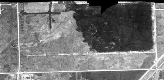
No trace of Ashburn Airport appeared to remain in the 1999 USGS aerial photo.
The 2002 USGS aerial photo showed the site has been densely redeveloped, with no trace visible of Ashburn Airport.
The site of Ashburn Airport is located southeast of the intersection of South Cicero Avenue & West 83rd Street.
____________________________________________________
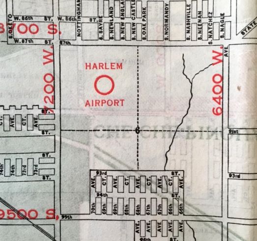
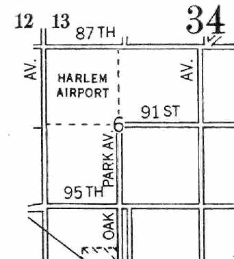
41.73, -87.796 (West of Chicago Midway Airport, IL)
Harlem Airport, as depicted on the 1930 Chicago Sectional Chart.
The earliest depiction which has been located of Harlem Airport was on the 1930 Chicago Sectional Chart.
According to the 3/2010 Air & Space Magazine article entitled “The Other Harlem”,
in 1932, at the intersection of 87th Street & Harlem Avenue in Oak Lawn, William Schumacher had purchased 140 acres of farmland with an airport in mind.
His brother Fred would manage it. Fred Schumacher visited the Challenger Air Pilots Association & invited the group to come use his brother’s airport.
The facility took shape, with grass sprouting where cornstalks had been plowed under, and a hangar & office sprang up along Harlem Avenue.
The article described, “Schumacher readily agreed to rent the lower end of the airport to the Challenger group,
but Hurd said that Schumacher initially insisted on segregation.
He was already running an all-white school.”
“Look, fellas,” he said, “I’m going to put you at the end of the field to save you from having any trouble with the other guys.”
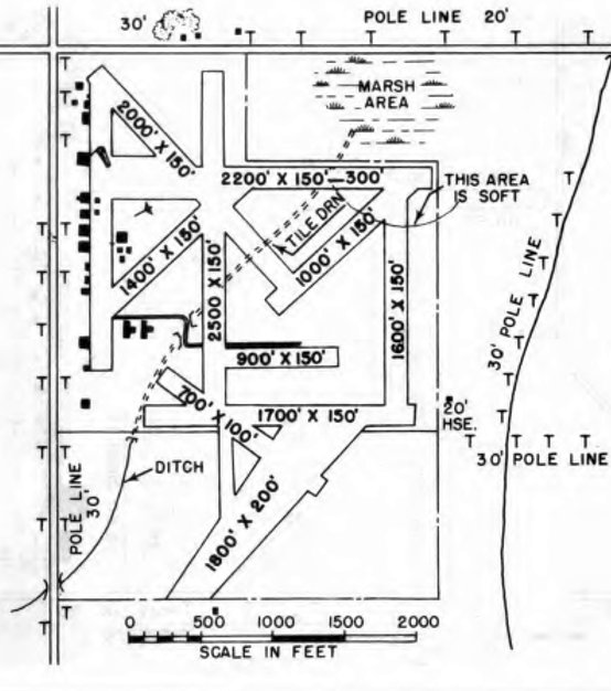
The article went on, “Black & white pilots parked their airplanes in separate hangars, but they shared Harlem’s 4 sod runways, the longest of which was 2,000'.
The rural area soon echoed with the thundering exhausts of Curtiss engines;
the sky above the corn & wheat fields of Worth Township teemed with WACOs, Travel Airs, and Taylor Cubs.”
Harlem Airport, as depicted on a 1933 Rand-McNally map (courtesy of Kevin Walsh).
The earliest directory listing which has been located of Harlem Airport
was in The Airport Directory Company's 1933 Airports Directory (courtesy of Chris Kennedy).
It described Harlem as a commercial airport, measuring 140 acres in size.
The field was said to have 4 sod runways, with the longest being the 2,000' east/west strip.
Hangars & buildings were said to be located on the southwest side of the field.
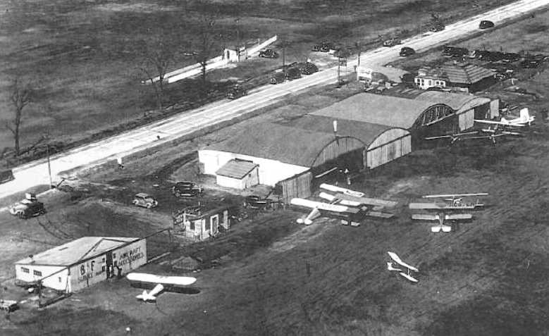
A circa 1930s aerial view of a number of aircraft & hangars at Harlem Airport, including the facilities of B&F Aircraft.
A 1937 Chicago map (courtesy of Chris Kennedy) depicted Harlem Airport
as occupying a square parcel of land on the southeast corner of South Harlem Avenue & West 87th Street.
A November 1938 aerial photo (courtesy of Chris Kennedy)
A total of 8 single-engine aircraft were visible parked around the hangars.
The May 1942 Chicago Sectional Chart (courtesy of Chris Kennedy)
depicted Harlem as a commercial/municipal airport.
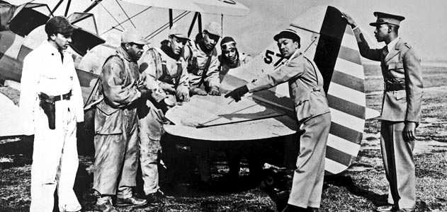
A WW2 era photo of military flight students with a Waco UPF-7 trainer at Harlem Airport.
The Haire Publishing Company's 1945 Airport Directory (courtesy of Chris Kennedy)
described Harlem as a "class 1" airport, with 135 usable acres.
The field was said to be owned by Robert Wilson & operated by Robert Schumacher (of Schumacher Flying Service).
The manager was listed as Fred Schumacher.
The field was said to have 4 loam runways, with the longest being the 2,300' east/west strip, and a total of 5 hangars.
According to the 3/2010 Air & Space Magazine article, “In the post-war years, Harlem Airport grew even busier, with 6 flying schools, a repair service, and 6 hangars.
Forty acres were added, and 10 unpaved runways crisscrossed the field.”
A circa 1940s photo of an unidentified pilot & a Piper Cub at Harlem Airport.
Susan Dolman Webb reported, “Harlem Airport... My mother learned to fly there in the late 1940s at Crea Flying School & subsequently became a Flight Instructor.”
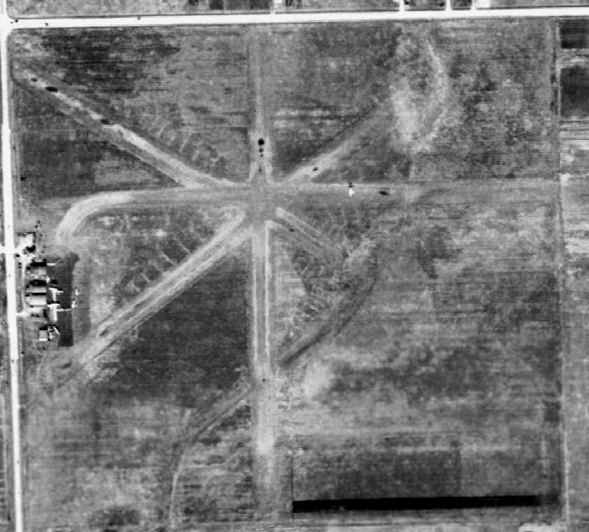
A 12/4/51 USGS aerial view depicted the original set of 4 runways at Harlem at the northwest corner,
as well as at least another 4 unpaved runways which had been added at some point between 1938-51 on the southeast side.
A dozen light aircraft were visible parked around the hangars on the west side of the field.
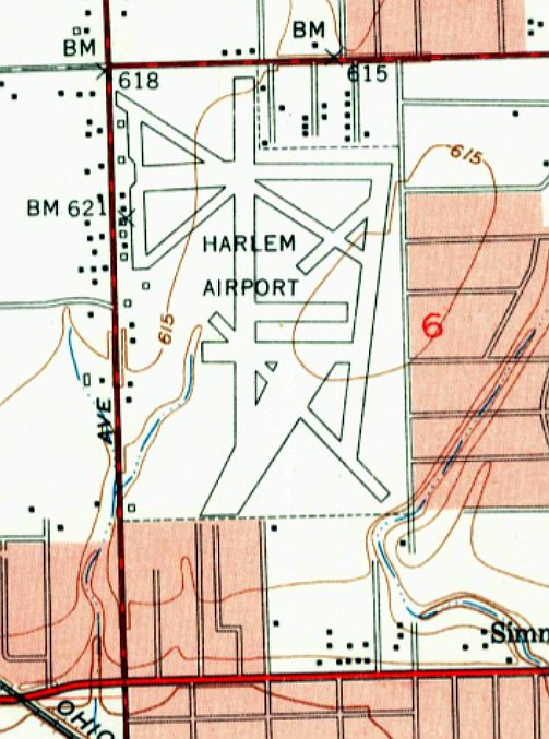
The 1953 USGS topo map depicted Harlem Airport as having no less than 10 runways,
and a number of small buildings along the west side.
The 1953 IL Airport Directory (from the University of IL, courtesy of Daniel McGill) depicted Harlem Airport as having no less than 10 runways,
with the longest being a 2,200' east/west strip.
A large number of small buildings were depicted along the west side.
The January 1954 Chicago Local Aeronautical Chart (courtesy of Chris Kennedy)
depicted Harlem Airport as having a 3,400' unpaved runway.
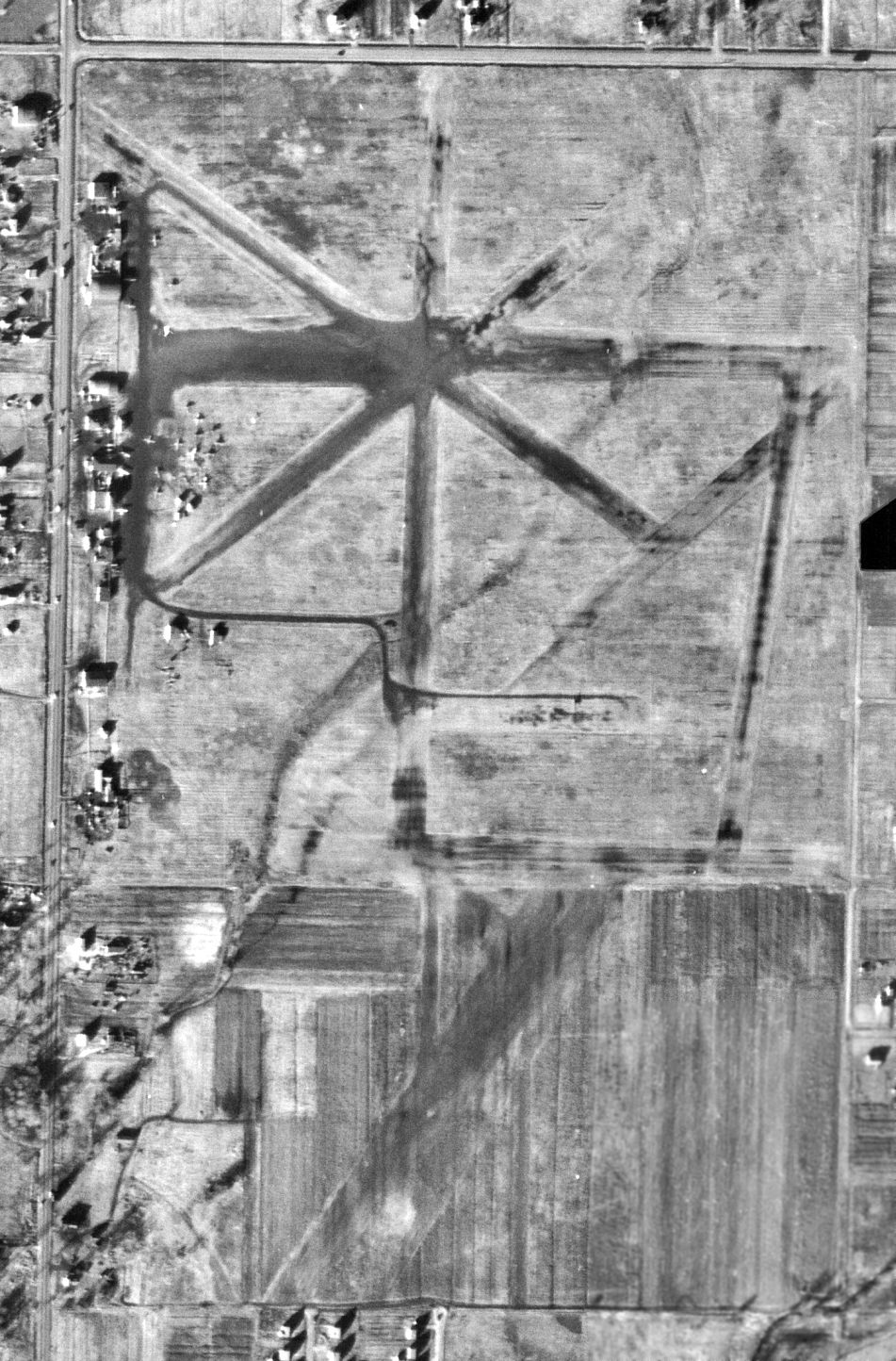
Harlem Airport was evidently closed (for reasons unknown) at some point between 1954-56,
as its picture in the 1956 IL Airport Directory (courtesy of Chris Kennedy) was overlaid with the word "closed".
The aerial photo in the directory was evidently taken several years prior to 1951 though,
as it depicted Harlem as having an amazing array of no less than 10 turf runways,
with the longest being the 3,400' north/south strip.
The operators were listed as Crea's Flying Service, Wilbur Bohl Flying Service,
and Fred Schumacher (who was also listed as the airport manager).
A few small buildings were depicted along the west side of the field,
along with a small (approximately 5) number of light aircraft.
According to the 3/2010 Air & Space Magazine article, “In September 1956 the airport lost its lease.
A parcel of land that had once been a cornfield was transformed once more,
this time into a residential subdivision & a shopping center named Southfield Plaza.”
A 1961 aerial view showed that a shopping center had been built over the northwest corner of the site of Harlem Airport,
with the remainder of the property having been filled in with residential streets.
Not a trace of the former airport appeared to remain.
The 2002 USGS aerial photo showed no trace remaining at the site of Harlem Airport.
According to the 3/2010 Air & Space Magazine article, “Today, customers walk to Shop ’N Save, Hobby Lobby, and Walgreens
on pavement where leather-helmeted pilots once revved engines to taxi & take off.
Grassy airstrips scarred by ruts have disappeared under smooth streets lined with houses & trees.
The acreage’s only link to aviation is several hundred feet overhead, where airliners descend toward landings at Midway Airport.”
The site of Harlem Airport is located southeast of the intersection South Harlem Avenue & West 87th Street.
____________________________________________________
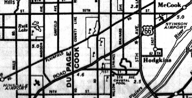
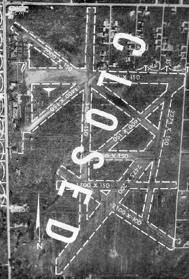
Stinson Airport, La Grange, IL
41.788, -87.852 (West of Chicago Midway Airport, IL)
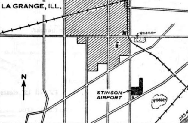
Stinson Airport, as depicted on the 1/14/30 Commerce Department Airway Bulletin (courtesy of Mike Denja).
The date of construction of Stinson Airport has not been determined.
The earliest depiction which has been located of Stinson Airport was on the 1/14/30 Commerce Department Airway Bulletin (courtesy of Mike Denja).
The 1/14/30 Commerce Department Airway Bulletin (courtesy of Mike Denja) described Stinson Airport
as a commercial airport owned by the Chicago Aero Sales Corporation & operated by Arthur Killips.
It was said to consist of a 80 acre L-shaped grass field measuring 2,600' east/west, with 3 hangars along the southwest side.
The earliest aeronautical chart depiction which has been located of Stinson Airport was on the 1930 Chicago Sectional Chart.
A biography of Milton Hershberger (courtesy of Ann Smart) said,
“In 1930, Hersberger was working at Chicago's Stinson Airport as chief pilot for Art Killip's passenger service.”
The earliest directory listing which has been located of Stinson Airport
was in The Airport Directory Company's 1933 Airports Directory (courtesy of Chris Kennedy).
It described Stinson as a commercial airport, measuring 80 acres in size.
The field was said to have 2 sod runways, each 1,000' long, oriented north/south & east/west.
A November 1938 aerial photo (courtesy of Bruce Lathrop)
The May 1942 Chicago Sectional Chart (courtesy of Chris Kennedy)
depicted Stinson as a commercial/municipal airport.
The Haire Publishing Company's 1945 Airport Directory (courtesy of Chris Kennedy)
described Stinson as a "class 2" airport, with 110 usable acres.
The field was said to be owned & operated by Midwest Flying Service, Inc.,
and the manager was listed as James Bird.
The field was said to have a single 2,870' northeast/southwest crushed stone runway,
two shorter sod & cinder runways, and 5 hangars.
Stinson Airport, as depicted on a 1947 street atlas.
A 1951 aerial view depicted a total of 18 light aircraft parked on the southwest side of Stinson Airport.
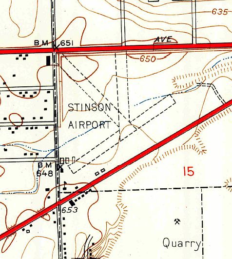
The 1953 USGS topo map depicted Stinson Airport as having 3 unpaved runways & several small buildings on the southwest side.
The January 1954 Chicago Local Aeronautical Chart (courtesy of Chris Kennedy)
depicted Stinson Airport as having a 2,400' unpaved runway.
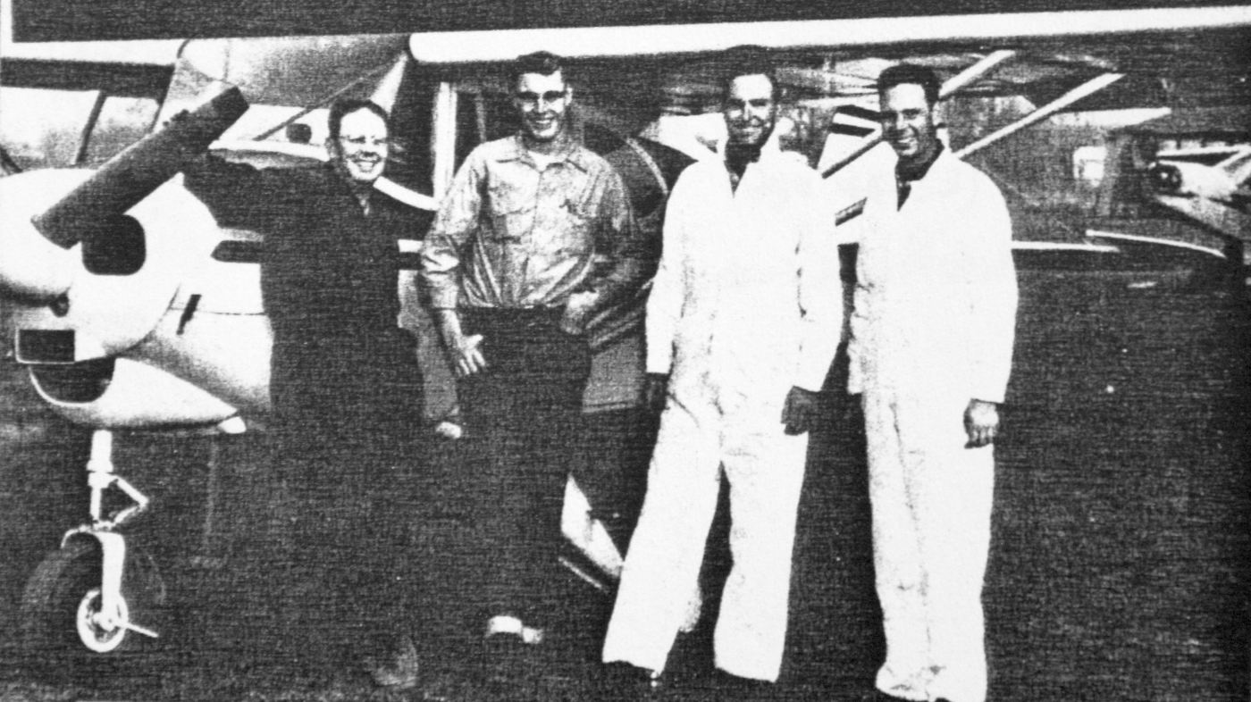
A circa 1955 photo (courtesy of Bruce Mabee) taken at Stinson Airport,
which Bruce observed showed “Orland Mabee, Les Carlson, Tony Esposito (possibly) and Jim Lee.
They are framed by the company's Tri-Pacer, with the nose of one of the 8 Piper Cubs in the background.”
Bruce Mabee recalled, “My father, Orland Mabee, was the owner of La Grange Aviation, and the Manager & main flight instructor of Stinson Airport in the mid & late 1950s.
With years of daily instruction time at Stinson, Mabee logged over 20,000 hours of lifetime flight time. His wife, Sophie, was the bookkeeper.
Jim Lee was the main mechanic in the Stinson shop (at the West end of the property).
Legendary Pete Peffer (Pfeffer?) was a consulting mechanic. Stories of Pete say he could diagnose an aircraft engine by hearing its sound as it flew over.
Stinson prepared many pilots on the GI Bill, military support for veterans.
It was apparently the busiest small airport in the Chicago area for a period in the 1950s.
Stinson graduates became pilots for major airlines.”
Bruce continued, “Of the many characters (that all small airports seem to attract),
Elmer Mott, inventor of the Hammerknife Mower, flew his SeaBee amphibious plane out of Stinson for many years.
One story of employee loyalty was that when it seemed that gasoline was being stolen from the pumps overnight,
two line boys hid in the bushes for days until they caught the thieves.
Orland claimed the loyalty resulted from the fact that when he hired someone, if they performed well in the first 2 weeks, he doubled their pay instantly.
As son of the owner, my most memorable job was to scrape the oil crud that caked up under each fuselage of the Piper Cubs & Tri-Pacer.
Luckily, he did teach me to fly when I was 10 years old, so it was not a bad deal!”
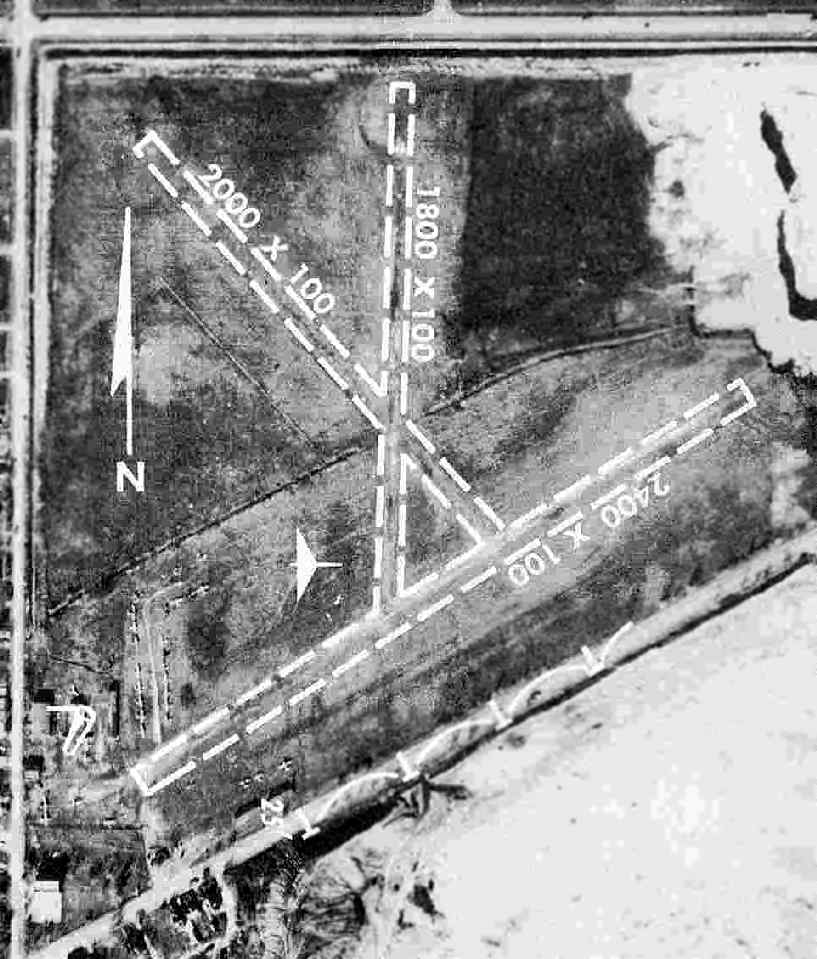
The 1956 IL Airport Directory (courtesy of Chris Kennedy)
depicted Stinson as having 3 "turf & cinder" runways,
with the longest being the 2,400' northeast/southwest strip.
The operator was listed as LaGrange Aviation, Inc., and the manager was listed as Orland Mabee.
The aerial photo in the directory depicted a few small hangars at the southwest corner of the field,
around which were parked a total of approximately 30 light aircraft.
A 9/1/56 Chicago Tribune article stated “The quarry company which owns the land [under Stinson Airport]
has informed the airport operators that they have another 2 or 3 years of operation at least, before excavation of stone closes the field.
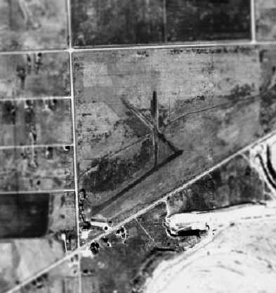
The quarry closed the airport in 1958.”
The last aeronautical chart depiction which has been located of Stinson Airport was on the January 1959 Chicago Sectional Chart.
It depicted Stinson as having a 2,200' unpaved runway.
Stinson Airport was no longer depicted at all on the June 1959 Chicago Sectional Chart.
A 1962 aerial view showed that several roads had been built across the site of the airport.
Several of the hangars had been removed, but the western hangar (adjacent to the road) was still standing.
A 1972 aerial view showed that one former Stinson Airport hangar still remained standing.
The majority of the airport property had been excavated as a quarry.
A 1974 aerial view showed that the last hangar had been removed at some point between 1972-74.,
eliminating the last trace of Stinson Airport.
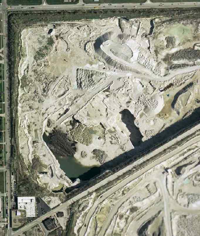
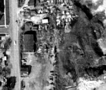
The 2002 USGS aerial photo showed the quarry covering the site of Stinson Airport.
Michael Bloome reported in 2005, “I work directly across the street from where the airfield once stood.
Where Stinson once stood is a quarry several hundred feet deep.
In fact the quarry is so large & deep at this point in time that it has caused the permanent closing of Route 66
(or as it is known by its real name Joliet Road) due to repeated explosions.”
The site of Stinson Airport is located southeast of the intersection of East Avenue & East 55th Street.
____________________________________________________
Since this site was first put on the web in 1999, its popularity has grown tremendously.
If the total quantity of material on this site is to continue to grow,
it will require ever-increasing funding to pay its expenses.
Therefore, I request financial contributions from site visitors,
to help defray the increasing costs of the site
and ensure that it continues to be available & to grow.
What would you pay for a good aviation magazine, or a good aviation book?
Please consider a donation of an equivalent amount, at the least.
This site is not supported by commercial advertising –
it is purely supported by donations.
If you enjoy the site, and would like to make a financial contribution,
you
may use a credit card via
![]() :
:
Please consider checking the box to make a monthly donatation.
For a mailing address to send a check, please contact me at: paulandterryfreeman@gmail.com
If you enjoy this web site, please support it with a financial contribution.
please contact me at: paulandterryfreeman@gmail.com
If you enjoy this web site, please support it with a financial contribution.
____________________________________________________
This site covers airfields in all 50 states.