Abandoned & Little-Known Airfields:
Florida: Southern Miami Area
© 2002, © 2022 by Paul Freeman. Revised 2/4/22.
This site covers airfields in all 50 states: Click here for the site's main menu.
____________________________________________________
Please consider a financial contribution to support the continued growth & operation of this site.
Brown's Airport / Aero Country Club (revised 2/4/22) - Chapman Field (revised 3/24/19) - Compton Flying C Ranch Airport (added 3/12/20)
Homestead Municipal Airport (revised 9/29/18) - Kendall Gliderport (revised 2/4/22) - Miami Gliderport (revised 11/19/17) - Richmond NAS (revised 2/4/22)
____________________________________________________
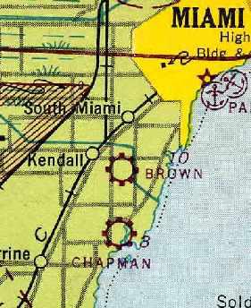
Compton Flying C Ranch Airport, Miami, FL
25.656, -80.349 (Southwest of Downtown Miami, FL)
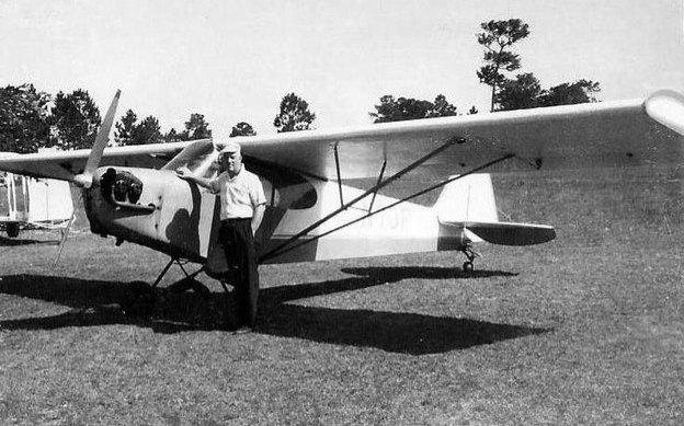
A circa 1959 photo of Captain Fritz Compton with his Piper J3 Cub towplane at Compton Flying C Ranch Airport (courtesy of Burt Compton).
No airfield was depicted at this location on a 1940 aerial photo.
Burt Compton recalled, “My father, Eastern Air Lines Captain Fritz Compton, built a dream home for my mother on open land south of Miami in 1947,
and graded a 1,900' northwest/southeast turf airstrip for Cubs & gliders, with nothing but tomato farms beyond each end.
At the time he could have bought another 5 acres past the south end, but he was a pay-cash guy, having lived through the 1930s depression era.
It was the home of the South Florida Soaring Association glider club.
Compton Flying C Ranch Airport was never listed on Sectional Charts as it was private.”
No airfield was depicted at this location on USGS topo maps from 1950/57/70/88.
According to Miami Gliders, “Fritz Compton built a grass airport just west of Route 1 near what is now known as The Falls shopping center.
The Compton family hosted the local soaring group known as the South Florida Soaring Association.
Glider pilots from around the world would gather in the winter to soar at the Compton Flying C Ranch.
Notable pilots included German legend Peter Riedel, French pilot Rene Comte, American soaring pioneer Captain Ralph Barnaby,
sailplane designer Dick Schreder, aviation photographer and writer Hans Groenhoff, and SSA President William Coverdale.”
The earliest depiction which has been located of Compton Flying C Ranch Airport
was a circa 1959 photo of Captain Fritz Compton with his Piper J3 Cub towplane (courtesy of Burt Compton).
According to Miami Gliders, “In the early 1960s the South Florida Soaring Association, flying at Compton's Flying C Ranch,
decided that they needed a gliderport further inland closer to the better thermal conditions near the Everglades, and to better utilize the sea breeze front.”
They moved to the nearby Miami Gliderport.
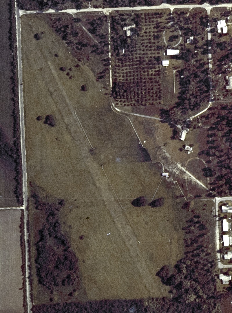
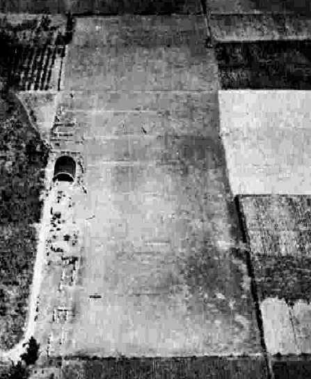
A 6/23/69 aerial photo showed Compton Flying C Ranch Airport to have a southeast/northwest grass runway, with a few small buildings on the east side.
There were no aircraft visible on the field.
Burt Compton recalled, “Compton Flying C Ranch Airport was 12 air miles southwest of Miami,
but the houses & shopping centers eventually moved south, surrounding our airport in the 1980s.
The occupants of the houses on that 5 acres that he could've, should've bought were the loudest to complain
to the County or to the FAA about Cubs, Stearman biplanes & gliders departing low over their homes.
My sisters & I were fortunate to grow up on our sweet little airport surrounded by a few men & women legends of aviation who would visit us in the winter.
My last flight out was in 1993.”
A 1994 aerial view looking west showed the grass runway of Compton Flying C Ranch Airport remained clear, but less distinct, with no sign of recent aviation use.
Burt Compton recalled, “Dad sadly sold our beautiful grass airport to an aggressive developer who covered it in zero lot-line houses.
There is no clue that an airport ever existed on the site.
How many small airfields across North America have disappeared this way? I bet you can name a few.
Just a few miles of our Compton Flying C Ranch Airport, it was the last to disappear after Brown's Airport / Aero Country Club,
Wedge's strip, Charlie Burr's strip, Curtis Pitts strip, Miami Gliderport, Kendall Gliderport and many more farther southwest of Miami.
And when the County decides to impose stricter zoning rules & increase the taxes, it's over.”
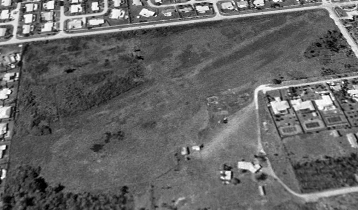
A 1999 aerial photo showed houses being built over the former Compton Flying C Ranch Airport runway,
but the former airfield buildings on the east side remained intact.
A 2005 aerial photo showed the former airfield buildings remained standing on the east side.
A 2007 aerial photo showed the former airfield buildings had been removed at some point between 2005-2007 of the east side.
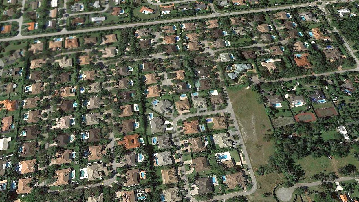
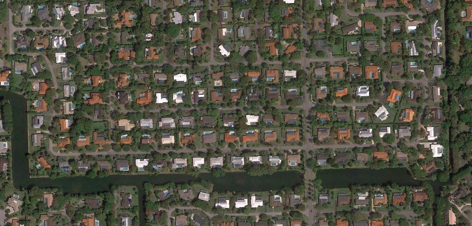
A 2018 aerial view looking west showed the site of Compton Flying C Ranch Airport covered by dense housing.
Curiously, the last remaining trace of the little airport is the remains of its driveway, visible in a small patch of clear land at bottom-right.
According to Burt Compton, Compton Flying C Airport was located along Southwest 97th Avenue between 120th & 128th Streets.
Thanks to Burt Compton for pointing out this airfield.
___________________________________________________
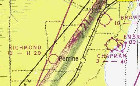
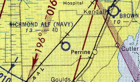
25.604, -80.585 (Southwest of Downtown Miami, FL)
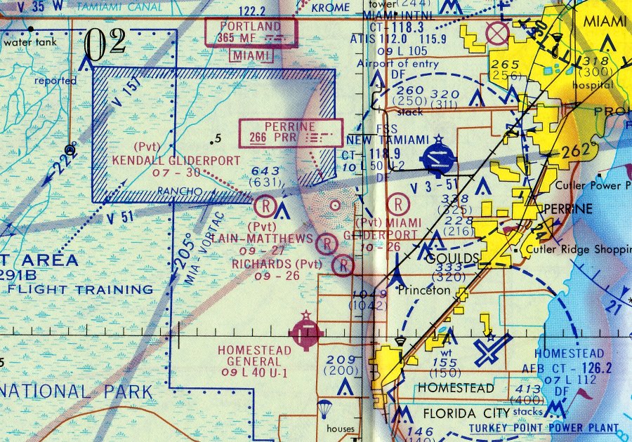
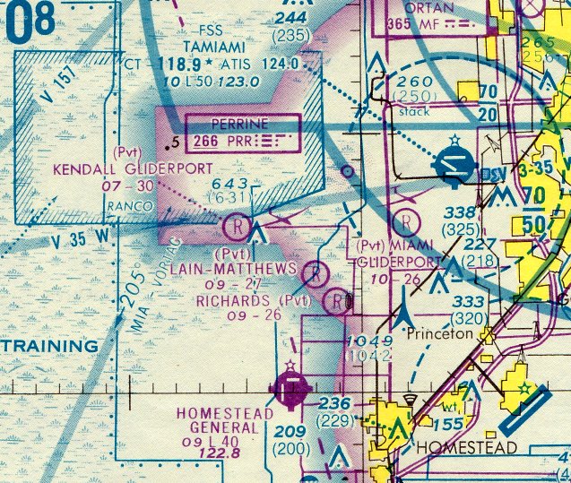
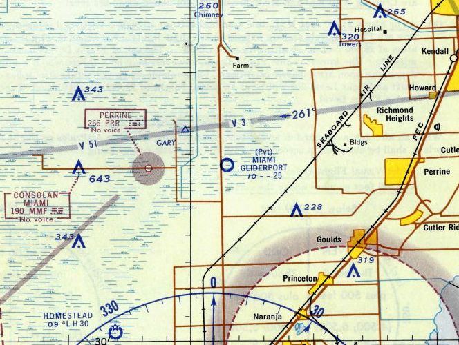
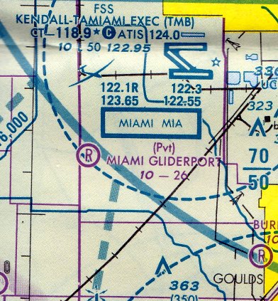
Kendall Gliderport, as depicted on the 1971 Miami Sectional Chart.
Kendall Gliderport was evidently established at some point between 1964-71,
as it was not yet depicted on a 1964 aerial photo or on the 1964 Miami Local Aeronautical Chart (courtesy of Tim Zukas).
According to Miami Gliders, “In the early 1970s, Mary Gaffaney, World Champion aerobatic pilot & owner of Kendall Flying School
established a commercial glider operation on land she purchased next to Everglades National Park.
She subsequently leased her Kendall Gliderport to other glider school operators who had difficulty growing the business at such a remote location.
However, dozens of new glider pilots were trained at Mary's Kendall Gliderport.
In spite of the snakes & mosquitoes Kendall Gliderport enjoyed the best soaring conditions in South Florida,
as the convergence of the Atlantic Ocean & Gulf of Mexico seabreeze fronts occasionally boosted cloud bases to over 8,000'.
On a few occasions air mass wave was encountered.
Bob Youngblood and Benny Flowers were among those to ride the wave above the cumulus cloud layer to over 10,000'.
Bill Harris, who had been flying sailplanes since the 1940s, was a fixture at Kendall Gliderport & mentor to many new glider pilots.
Later, Brian Thorpe operated Sunspot Soaring at Kendall Gliderport.”
The earliest depiction which has been located of Kendall Gliderport was on the 1971 Miami Sectional Chart.
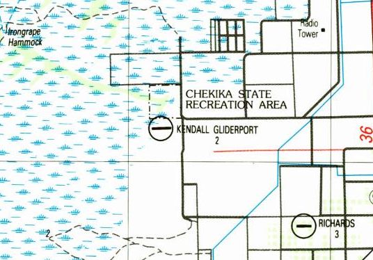
It depicted Kendall Gliderport as a private airfield having a 3,000' unpaved runway.
The earliest topo map depiction which has been located of Kendall Gliderport was on the 1973 USGS topo map.
It depicted a single east/west unpaved runway, with one small building on the northeast side.
Bob Mason recalled, “Kendall Gliderport... I did quite a bit of skydiving there in 1974-75 with Everglades Sport Parachutists.”
The March 1978 Miami Sectional Chart depicted Kendall Gliderport as a private airfield having a 3,000' unpaved runway.
The earliest photo which has been located of Kendall Gliderport was a 1980 aerial view.
It depicted Kendall Gliderport as having a single unpaved east/west runway,
with a hangar on the northeast side near which was visible 2 gliders & 1 single-engine aircraft.
The August 1987 Miami Terminal Aeronautical Chart (courtesy of John Kielhofer) depicted Kendall Gliderport as a private airfield having a 3,000' unpaved runway.
The 1988 USGS topo map depicted Kendall Gliderport as having a single east/west runway.
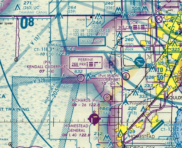
The last aeronautical chart depiction which has located of Kendall Gliderport was on the March 1989 Miami Sectional Chart.
It depicted Kendall Gliderport as a private airfield having a 3,000' unpaved runway.
According to Miami Gliders, “In the 1990s Mary Gaffaney's Kendall Gliderport was absorbed by the expansion of Everglades National Park & decommissioned as an airport,
and Burt Compton established Miami Gliders Flight School at Richard's Field Airport.”
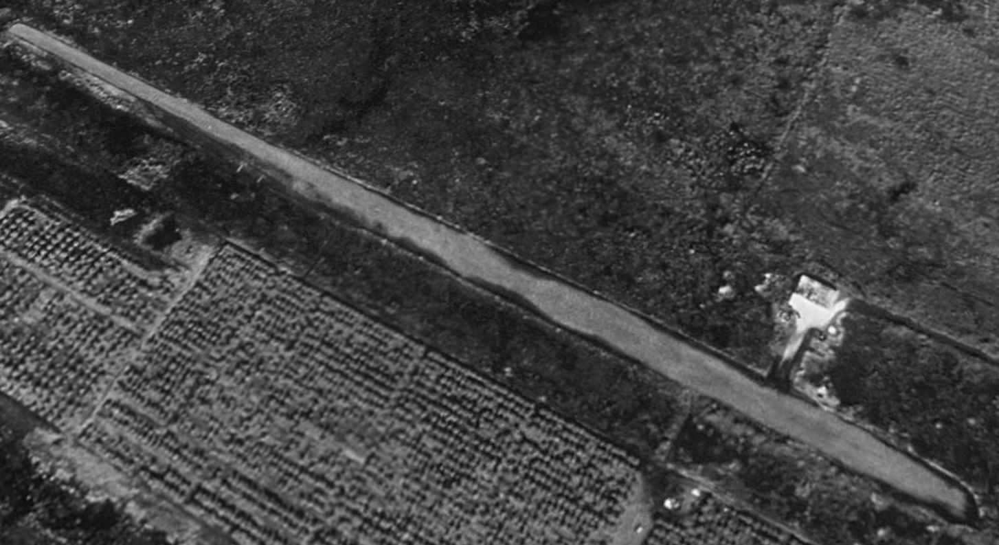
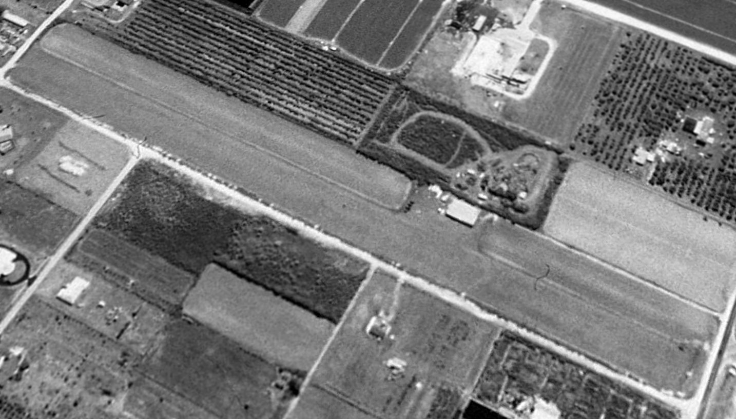
The earliest photo which is available of Kendall Gliderport was a 1994 aerial view looking northwest.
It depicted Kendall Gliderport as having a single unpaved east/west runway, with one small building on the northeast side.
There were no aircraft visible on the field.
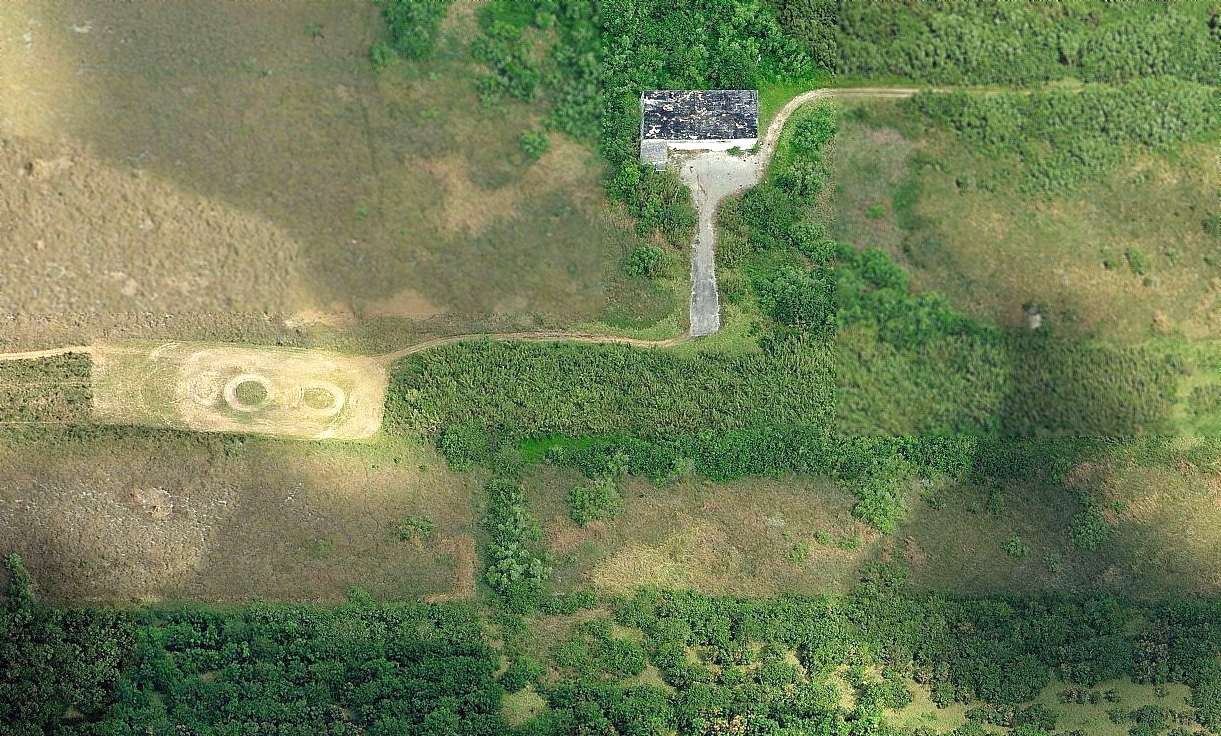
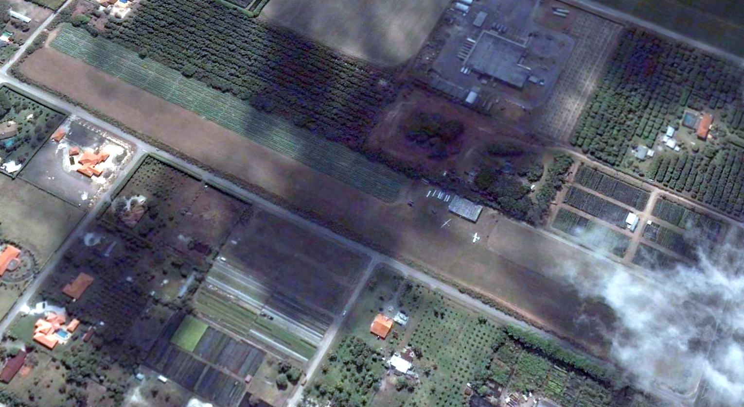
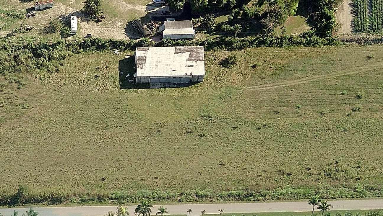
A circa 2005-2007 aerial view looking north at the Kendall Gliderport hangar & overgrown runway, showing no sign of recent aviation usage.
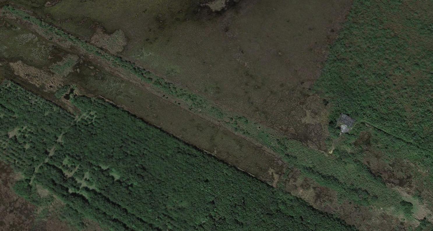
A 2016 aerial view looking northwest showed the Kendall Gliderport runway as overgrown but still recognizable,
and the hangar remained standing on the northeast side.
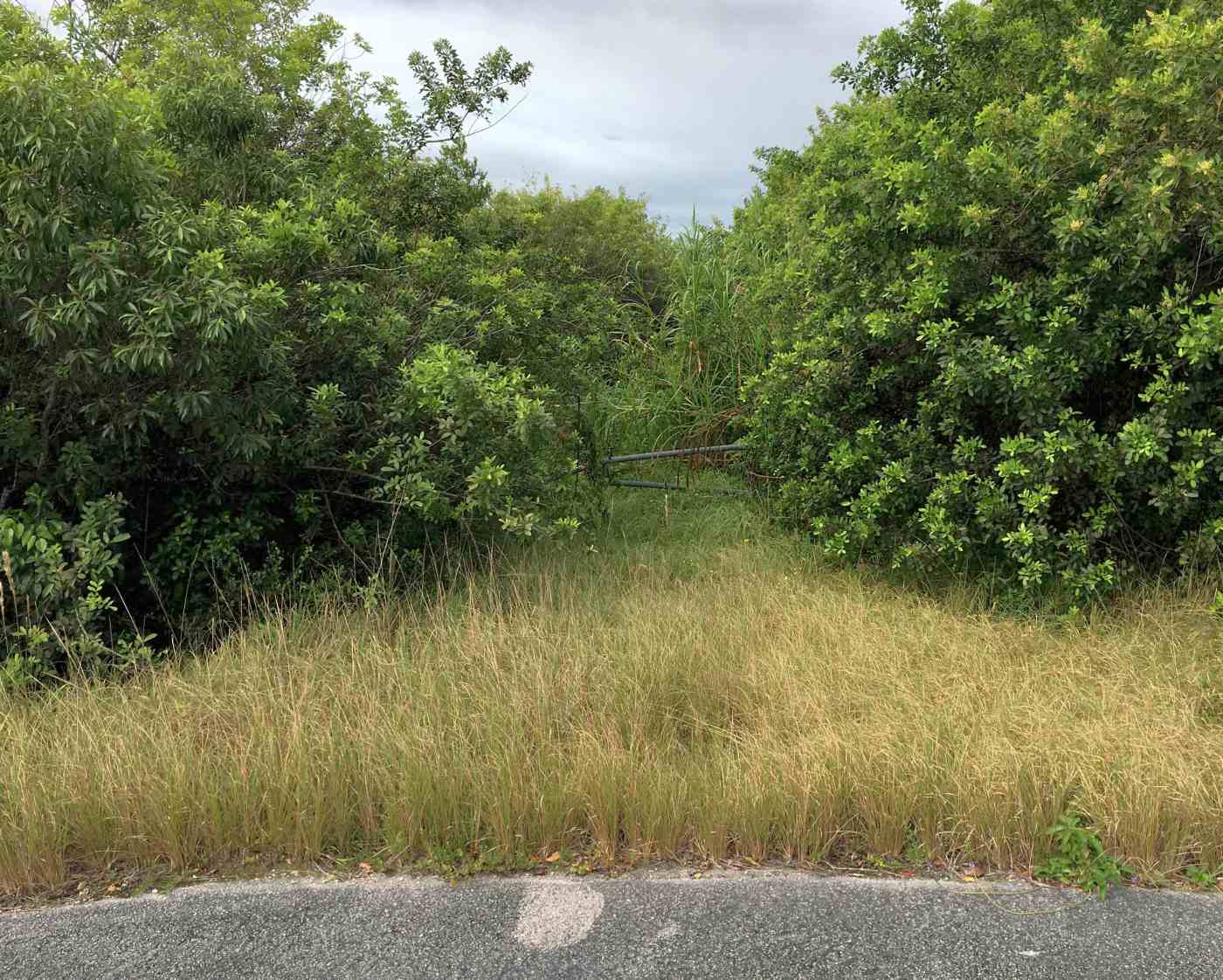
A 10/20/16 photo by Thomas Strom looking west at the entrance gate to the very overgrown path leading toward Kendall Gliderport.
Thomas reported, “I found its entrance gate & could not go on anymore.
There is what appeared to be an old walking path but it looked too overgrown to be of any use & I would not be surprised if part of the pathway is underwater.”
The site of Kendall Gliderport is located southwest of the intersection of Southwest 168th Street & Southwest 237th Avenue.
___________________________________________________
25.61, -80.476 (Southwest of Downtown Miami, FL)
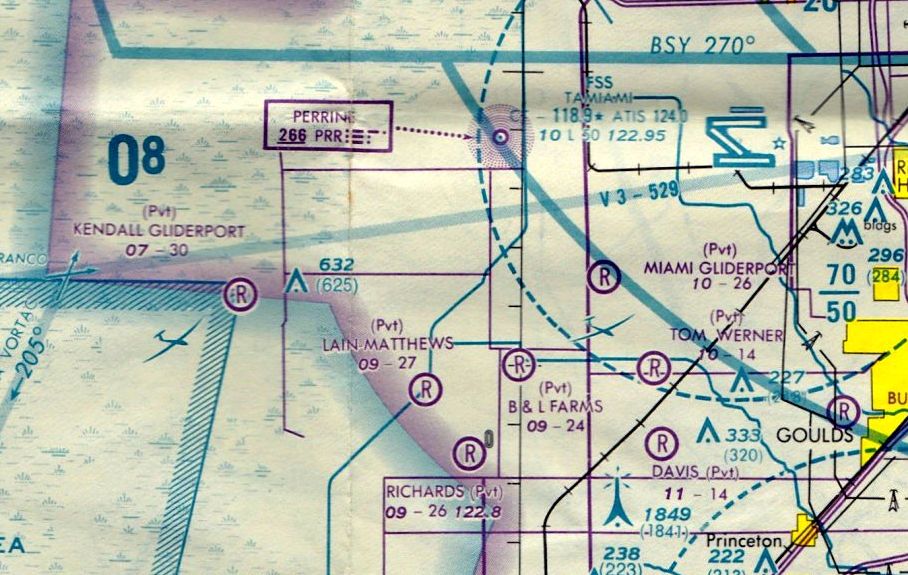
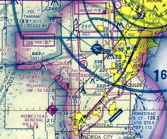
Miami Gliderport, as depicted on the 1964 Miami Local Aeronautical Chart (courtesy of Tim Zukas).
No airfield was yet depicted at this location on a 1952 aerial photo or on the 1962 Miami Local Aeronautical Chart (courtesy of Jonathan Westerling).
According to Miami Gliders, “In the early 1960s the South Florida Soaring Association, flying at Compton's Flying C Ranch,
decided that they needed a gliderport further inland closer to the better thermal conditions near the Everglades, and to better utilize the sea breeze front.
A committee was formed to arrange for zoning with Dade County & purchase a site near Homestead.
A site was chosen on Krome Avenue, however instead of the club purchasing the land as intended,
a small group of the club members preempted the club plans & bought the property themselves.
The club was grateful for the generosity of the syndicate that made the investment & agreed to pay rent to them which simplified club business.
Many years after the initial purchase the property was offered to the club but land values in the area had greatly increased
and the club could not make a timely decision to purchase.
The land was sold to another group of private individuals, and the club missed an opportunity to purchase the gliderport land.”
Miami Gliders continued, “Circa 1963 the site was named the Miami Gliderport & the club reorganized as Thermal Research Associates.
The gliderport had a 6,000 sq ft hangar & a Super Cub towplane.
Jim Parrott, a congenial high school teacher operated the Miami Soaring School at the gliderport with a Schweitzer 2-22 & a 1-26.
Jim was well loved & introduced hundreds of Miamians to the sport of soaring.
In the meantime club members John Randall & Fritz Sebek were flying their new KA-6 sailplanes.
George Arrents had the only Schweitzer 2-25 ever built, and Fritz Compton was building a Schreder HP-11 & waiting for his new Open Cirrus to arrive from Germany.
Other club members included Paul 'Pablo' Crowell who had a new German fiberglass Libelle H-301 (which he later sold to John Byrd);
Lou Salvatore had a Fournier RF4D motorglider & was partners with Harry Sinn in a Schweitzer 1-26.
Harry Sinn was professor of meteorology at the University of Miami & conducted 'thermal research'
which included tossing toilet paper out of his 1-26 into the thermal to determine direction of rotation of thermals.
Harry shared his observations of thermals & led lively post-flight debriefings of the day's weather.
Fritz Compton & Pablo Crowell would take their sailplanes to National contests, with Burt Compton serving as crew for both.
Happily, Fritz & Pablo flew well & almost always finished every contest task.
A Schleicher ASK-13 two-seat sailplane was acquired by the club & flown often by Hal & Scott Bingham.
Later, club gliders included a Blanik L-13, a IAR Lark & a Twin Astir.
The primary club instructor was Fred Brittain, succeeded by Scott Bingham.
Walt & Kay Cawby, and Chicho Estrada & his nephew Alfonso Jurado competed in many National contests.”
The earliest depiction which has been located of Miami Gliderport was a 1964 aerial photo.
It appears to show a single east/west unpaved runway, with 1 single-engine aircraft parked on the south side of the runway.
The earliest aeronautical chart depiction which has been located of Miami Gliderport was on the 1964 Miami Local Aeronautical Chart (courtesy of Tim Zukas).
It depicted Miami Gliderport as a private airfield with a 2,500' unpaved runway.
A 1969 aerial photo of Miami Gliderport showed that a hangar had been added at some point between 1964-69 on the south side of the runway.
The September 1980 Miami Sectional Chart depicted Miami Gliderport as a private airfield with a 2,600' unpaved runway.
A 1980 aerial view depicted several small objects on either side of the Miami Gliderport hangar, but no aircraft.
A 1986 aerial view depicted 2 gliders & 1 single-engine aircraft parked around the Miami Gliderport hangar.
The last aeronautical chart depiction which has located of Miami Gliderport was on the March 1994 Miami Terminal Aeronautical Chart.
It depicted Miami Gliderport as a private airfield having a 2,600' unpaved runway.
The earliest photo which is available of the Miami Gliderport was a 1994 USGS aerial view looking southeast.
It depicted Miami Gliderport as having a single grass east/west runway, with one small hangar on the south side.
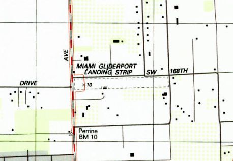
The 1994 USGS topo map depicted “Miami Gliderport Landing Strip”
as having a single unpaved east/west runway, with one small building on the south side.
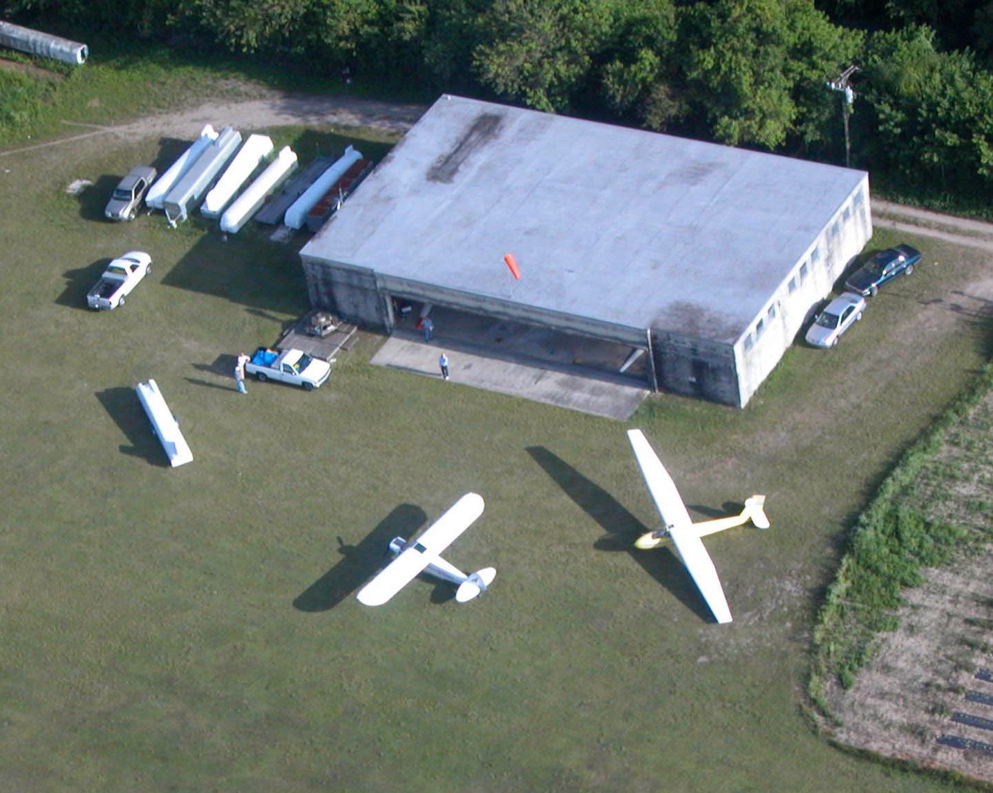
The earliest photos which are available showing aircraft at the Miami Gliderport was a series of 2003 photos by Thomas Strom,
this one showing a jumble of gliders & powered aircraft inside the Miami Gliderport at the start of a flying day.
Thomas recalled, “It was a beautiful place & one where I had the experience of going back in time to when the field operation was primitive & simple.
The hand pushing of the aircraft, the hand signals, the tow plane being a simple humble Piper Cub, a grassy runway, a simple hangar; it was like being in those 1920s & 1930s black & white pictures & films I've seen.
One guy (holding the glider's wing) even waved his hat on & laughed as my glider ride took off. It was so primal. To me, that was it, that was flying.
Up to that point, I was so used to modern-days conveniences of aviation and their formal operations (I'm thinking of the GA airports & the big airports; KTMB, KMIA, etc)
that it was a shock for me to learn that flying can be this simple & this basic.
I didn't realized the essentials of flying in the 1920/1930s had lived on in a different form.
So it was very inspiring & I tried to capture that with my photography during my short visits to the glider airfield.”
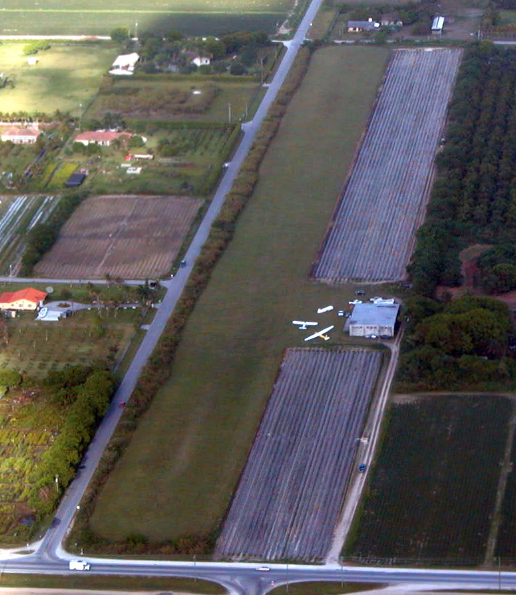
A 2003 aerial view by Thomas Strom looking east at Miami Gliderport, showing a glider & a powered aircraft outside the hangar.
A 2003 aerial view by Thomas Strom looking southeast at Miami Gliderport hangar, showing a glider & a powered aircraft.
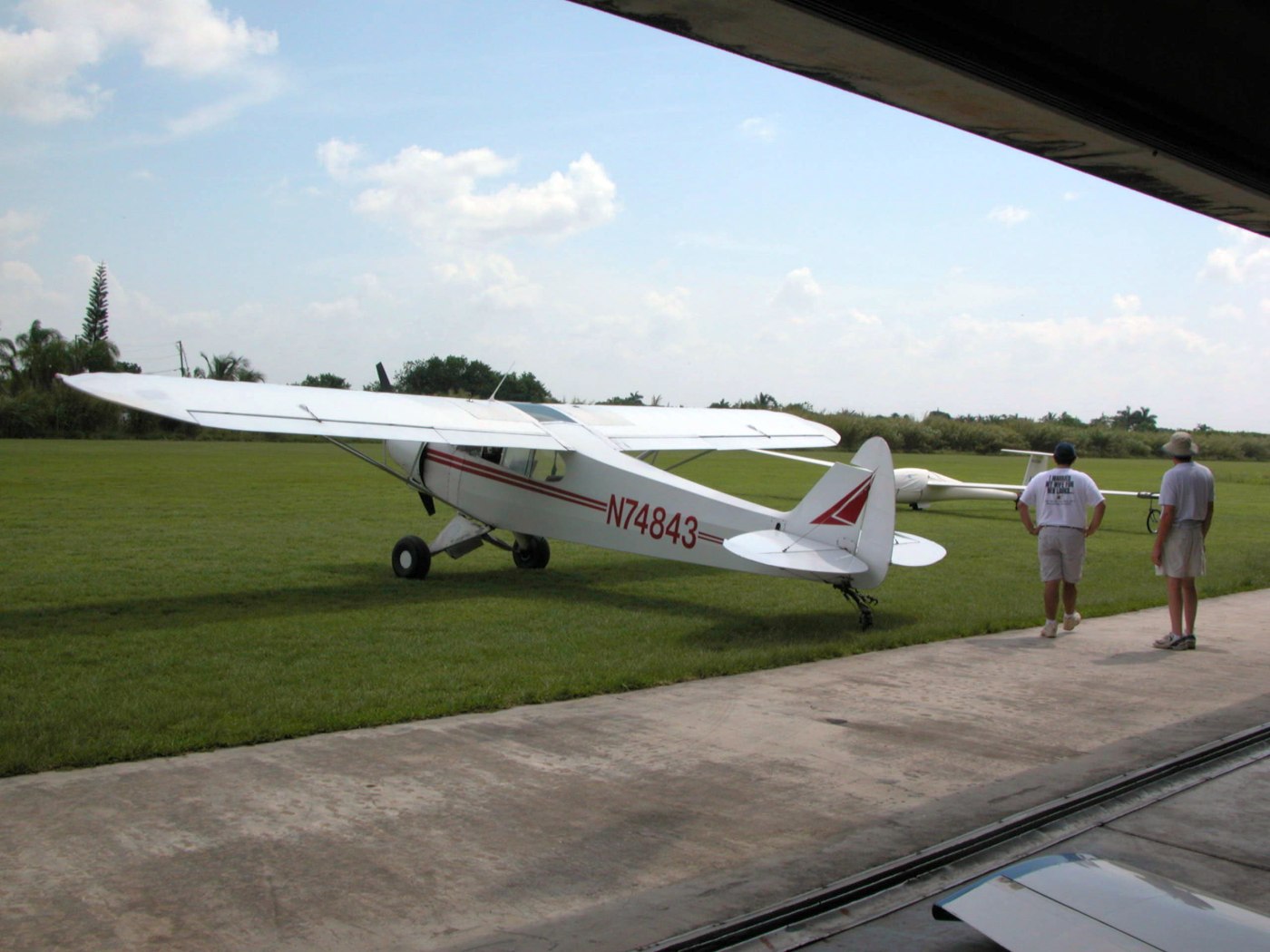
A 2003 photo by Thomas Strom of a Piper Cub tow plane & a glider outside the Miami Gliderport hangar.
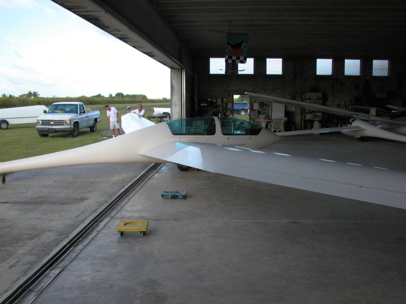
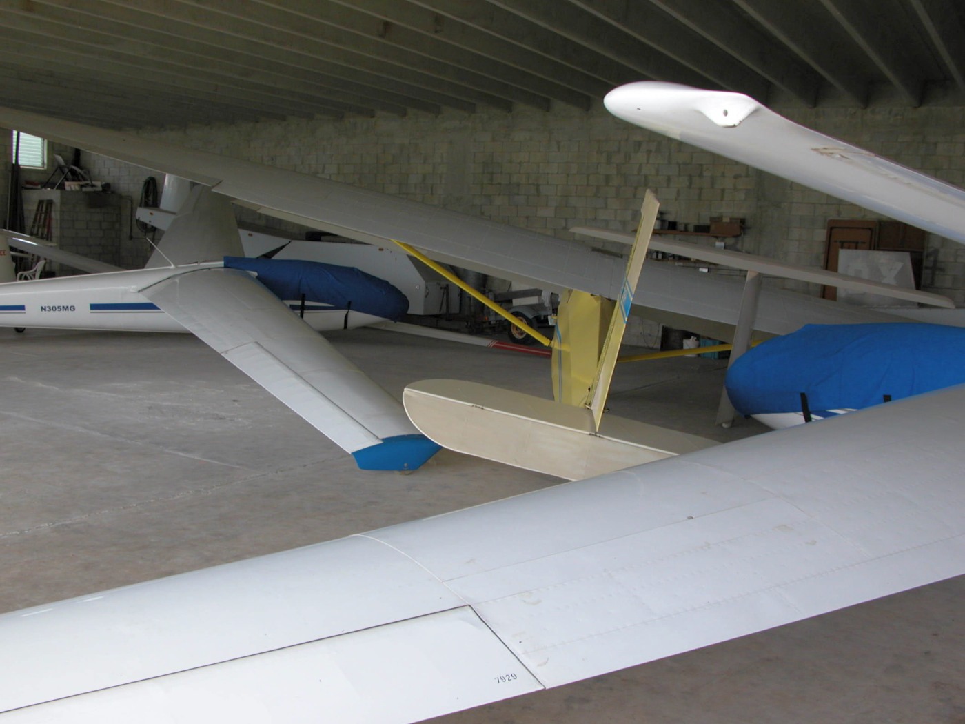
A 2003 photo by Thomas Strom of a glider (model undetermined) inside the Miami Gliderport hangar at the end of a flying day.
The last photo which has been located showing aircraft at the Miami Gliderport was a 2005 aerial view looking southeast.
It depicted one glider & one single-engine light aircraft parked near the hangar on the south side.
A circa 2005-2007 aerial view looking south at the Miami Gliderport hangar, showing no sign of recent aviation usage.
A 2007 aerial view showed the Miami Gliderport remained intact, but there was no sign of recent aviation usage.
Miami Gliderport had evidently been closed by 2009,
as a 2009 aerial view showed an asphalt road had been built across the runway, leading toward the hangar.
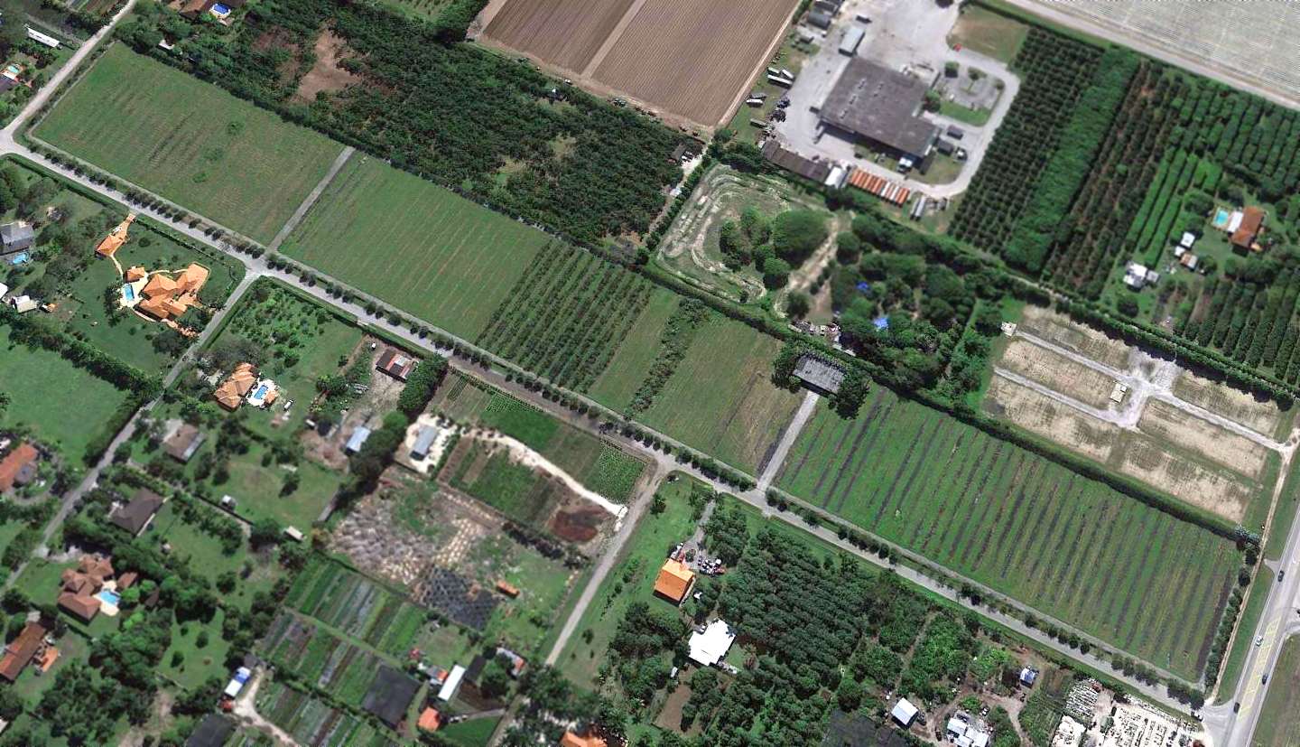
A 2016 aerial view looking southeast showed the Miami Gliderport former runway had been planted with rows of crops, but the hangar remained standing.
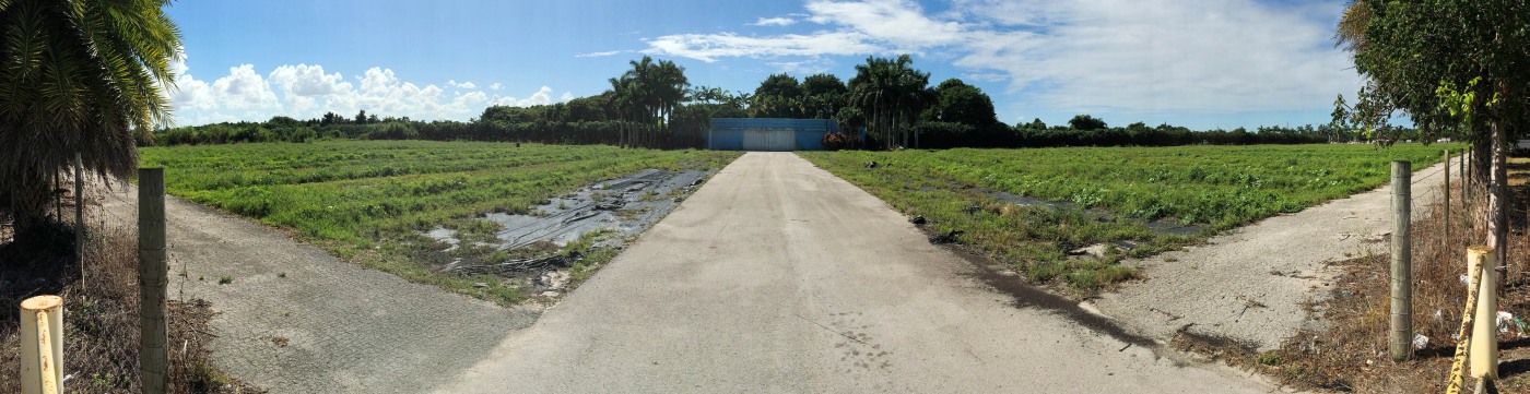
A 10/20/16 panoramic photo by Thomas Strom looking south at the site of Miami Gliderport.
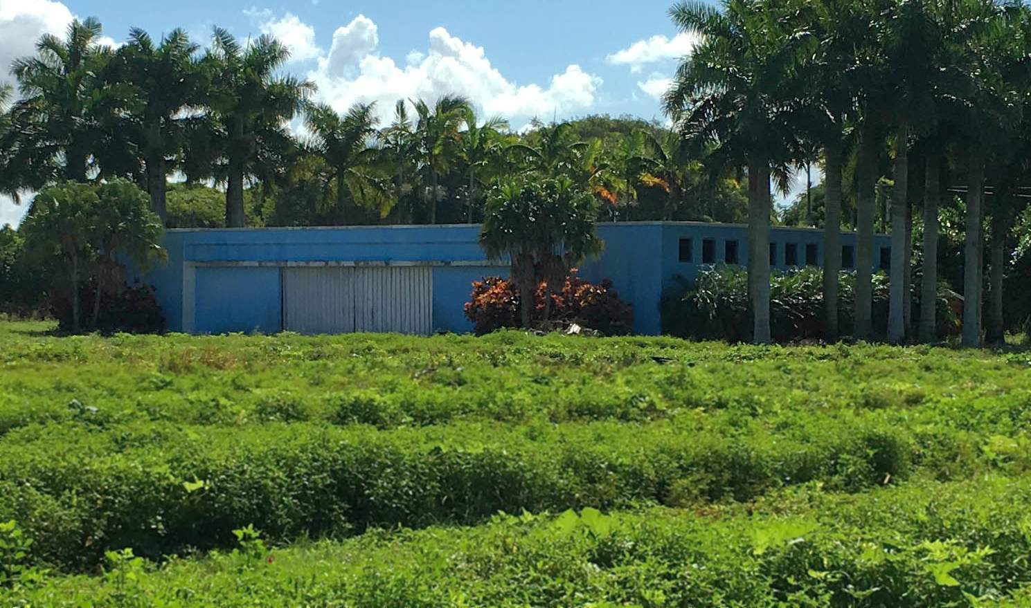
A 10/20/16 photo by Thomas Strom looking southeast at the former Miami Gliderport hangar.
Thomas observed, “At first look, I thought I was at the wrong location & had to double-check my location on my phone because the hangar has changed drastically & I didn't recognize it.
It has been painted blue & its doorway has been made narrower.”
The site of Miami Gliderport is located southwest of the intersection of Southwest 168th Street & Southwest 172nd Avenue.
Thanks to Thomas Strom for pointing out this airfield.
___________________________________________________
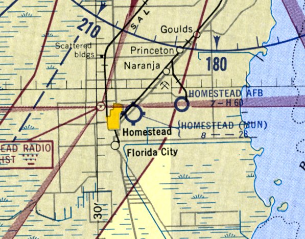
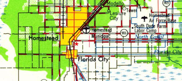
Homestead Municipal Airport, Homestead, FL
25.475, -80.465 (Southwest of Miami, FL)
Homestead Municipal Airport, as depicted on the June 1938 Miami Sectional Chart.
Homestead Municipal Airport was not yet depicted on the December 1935 Miami Sectional Chart.
According to the book “Homestead, Florida: From Railroad Boom to Sonic Boom”, “Homestead Municipal Airport was completed in December 1935.”
The earliest depiction which has been located of Homestead Municipal Airport was on the June 1938 Miami Sectional Chart,
which depicted Homestead as an auxiliary airfield.
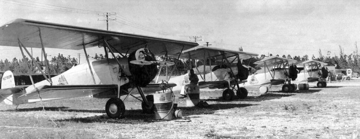
The earliest photo which has been located of Homestead Municipal Airport was a circa 1940s photo of 4 Delta Air Corps Huff-Dalend crop-dusters.
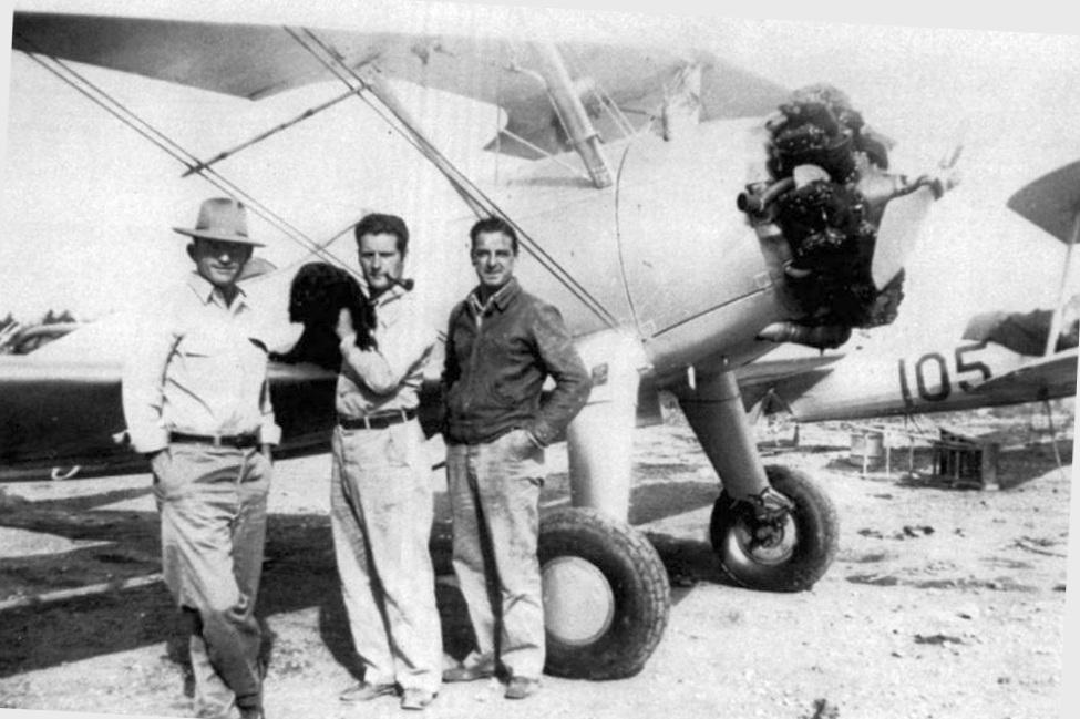
A circa 1940s photo of farmer Ernest Neal, pilot / CAA inspector / crop-dusting company owner George Eicher and pilot Victor Grisanti in front of a biplane at Homestead Municipal Airport.
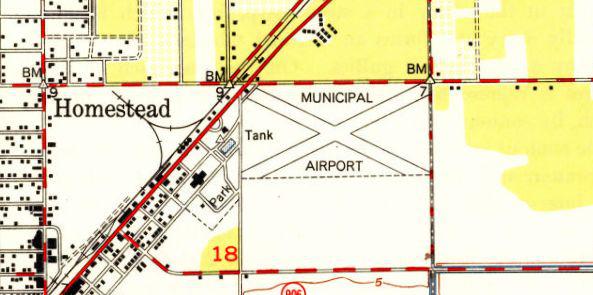
The 1950 USGS topo map depicted Homestead Municipal Airport as having 2 runways.
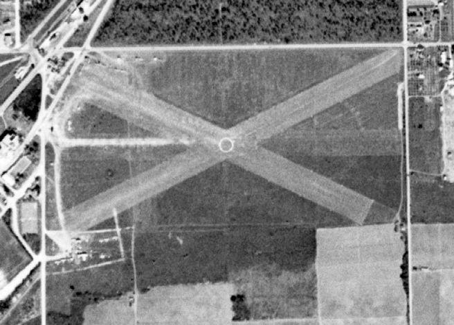
The last photo which is available showing Homestead Municipal Airport was a 11/29/50 aerial view,
which depicted it as having 3 unpaved runways, with several light aircraft parked around some small buildings on the northwest & southwest corners.
A 1952 aerial photo showed Homestead Municipal Airport in a similar fashion.
According to the book “Homestead, Florida: From Railroad Boom to Sonic Boom”,
“The Homestead Municipal Airport was officially closed in 1952,
but some use continued for a time, as evidenced by photos taken by Marlow Jacobsen.”
The last aeronautical chart depiction which has been located of Homestead Municipal Airport was on the February 1955 Miami Sectional Chart.
It depicted Homestead Municipal Airport as having a 2,800' unpaved runway.
The last depiction which is available of Homestead Municipal Airport was on the 1958 USGS topo map.
According to the website of the Homestead Rodeo (courtesy of Robert Wyman),
“The current rodeo arena was first used in 1958 & was dedicated as Tom Harris Field in 1960.
It sits on grounds of what was once the old Homestead City Airport.”
Homestead Municipal Airport was no longer depicted on the February 1960 Miami Sectional Chart.
A 1969 aerial photo showed a newly-constructed North Homestead Boulevard passing through the Homestead Municipal Airport site.
A 2014 aerial view did not appear to show any trace at the site of Homestead Municipal Airport.
The site of Homestead Municipal Airport is located south of the intersection of Campbell Drive & North Homestead Boulevard.
Thanks to Alex Price for pointing out this airfield.
____________________________________________________
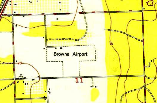
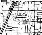
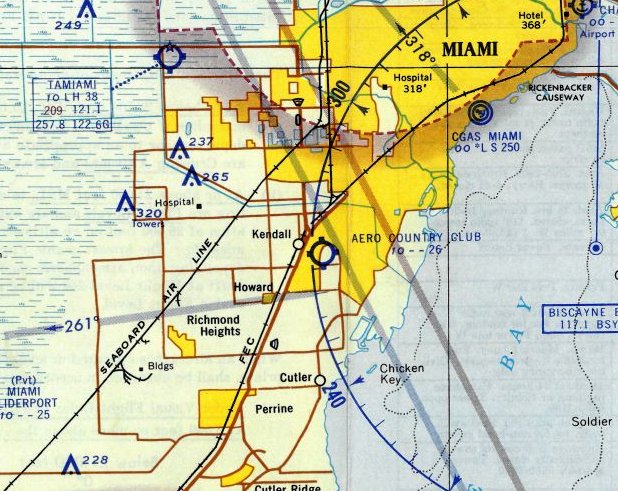
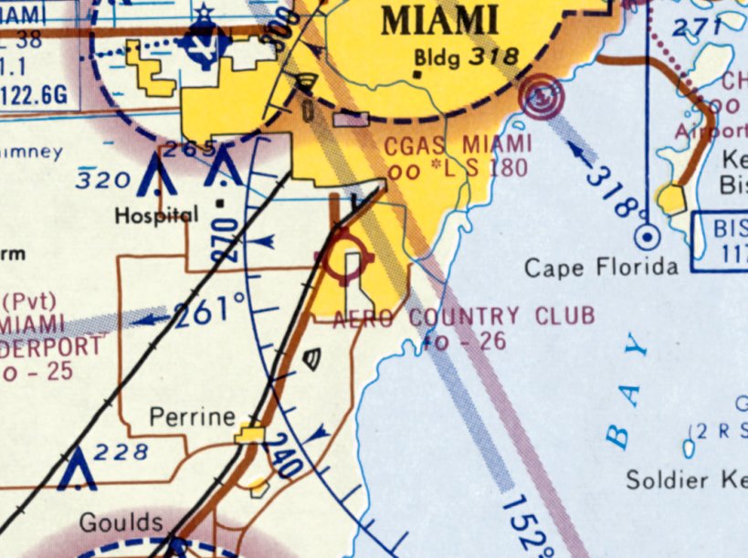
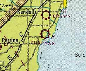
Brown's Airport / Aero County Club, Kendall, FL
25.67, -80.31 (Southwest of Downtown Miami, FL)
Brown Airport, as depicted on the 1943 Miami Sectional Chart (courtesy of Chris Kennedy).
Brown’s Airport was a small general aviation airfield located in the south Miami community of Kendall.
It was apparently established at some point between 1942-43,
as it was not yet depicted at all on a 1940 aerial view, the May 1941 Miami Sectional Chart,
or the June 1942 17M Regional Aeronautical Chart (according to Chris Kennedy).
The earliest depiction of Brown's Airport which has been located was on the 1943 Miami Sectional Chart (courtesy of Chris Kennedy).
It was depicted as a commercial airport.
Gene Neill recalled, “I'm probably one of the only few living souls who learned how to fly at Browns.
I took my first lessons at age 12, in 1943.
I started out in a J2 Cub - no brakes, no tail wheel & a 40 hp Continental engine.
When they got in a couple of J3s & moved me up to them, I thought I was a real fighter pilot!
What a great pity it is that Browns & Tamiami - and others like them - have been plowed under in the name of progress!”
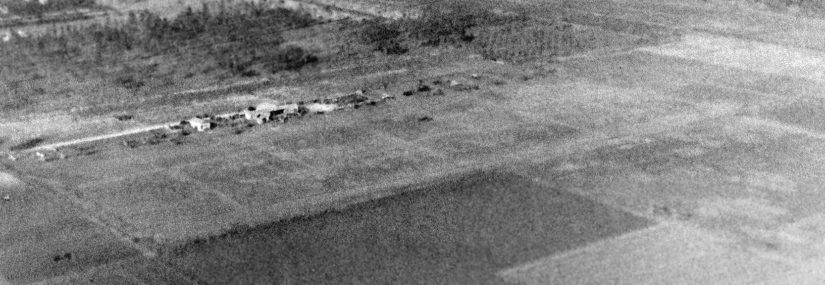
A 5/21/43 aerial view looking east from the 1945 AAF Airfield Directory (courtesy of Scott Murdock) depicted Brown's Airport
as consisting of a single east/west grass runway, with a hangar with a large number of light aircraft on the northwest side.
The April 1944 U.S. Army & Navy Directory of airfields (courtesy of Joe Benson)
described Brown's Airport as having a 2,000' unpaved runway.
A 1944-45 photo by Ruth Mullis of her Aeronca L-3 at Brown's Airport.
Ruth Mullis recalled, “I am a 'Rosie the Riveter': I worked in the WWII war equipment factories with millions of other women.
I was a template maker for parts of the wings on the Army Air Corps P-38 long distance fighter planes.
I became very interested in these planes & started going to Brown's to learn how to fly in 1944.
I loved it so much & after the factories closed Al Howe offered me a job at the airport running the flight school.
I jumped at the chance as my salary plus 60 hours / week free flying time sounded too good to say 'No'.”
Ruth continued, “Some of the crazy things at the airport: There were extremely tall Florida pine trees at the end of the east/west runway.
Getting the plane off the ground took quite a bit of maneuvering, having to make a sharp right turn to the south before the end of the grass runway so your plane could stay away from those tall trees.
That was very frightening to new pilots & others as their runway was extremely short anyhow.
One day a strange plane flew into our airport & he was in a brand new Ercoupe with some kind of inflatable fuel tank.
Of course everyone was out there inspecting it & he offered one of the crop dusters to take it up for a trial flight.
I believe it was Dave Acree who took off in it to the east but didn't make it over or around the trees.
That thing 'mushed' into the trees & he was sitting on a log when we went to pick him up.
We found him by smelling that 'busted' fuel tank.
He said 'Gee, I was wondering how long it would take for ya'll to find me,' He wasn't injured but that poor Ercoupe had had it!!”
Ruth continued, “I had around 25-30 miles to go to work. I lived in Dade County (northwest area); the back fence at my home was the north extension of Sunny South Airport.
Sometimes I would work later than my regular hours & Al would tell me to take a plane home instead of facing all the work traffic driving.
Sounded good to me; I could make it home in 10 minutes & tie down right next to my backyard.
I'd put my car in the hangar at work which was locked overnight. Then I'd fly back to work the next day. HOW ABOUT THAT??”
Ruth continued, “At Brown's there was a flying club called the T-Craft Club.
They had around 10-12 members & each one had an equal ownership of their Taylorcraft plane.
One of their members was ready for his private pilot's license flight & he asked me to fly with him & check him on his flight which I did.
I began to put him through the required maneuvers when, all of a sudden he reached over & pulled one of the control knobs up.
Not being familiar with the plane I looked at what he had done because that knob was painted red!
It was the fuel mix & he had leaned it out to where the prop was barely turning. In no uncertain terms, I slapped that thing down & told him to get back to the field ASAP.
The trainer planes back then had to be started by spinning the propellers. WHEW!!”
Ruth continued, “Also on our field was a WW2 tandem-seat plane. I don't remember the make.
We also had experienced pilots for that plane (they just liked to fly it). One day one of them wanted me to fly with him.
As I climbed into the seat he handed me a paper sack. I knew what to expect. Way up there in the sky he began to 'wring me out'.
Well it didn't work (I didn't get sick as his buddies on the ground told him I would). I'm sure they all were disappointed & I just giggled to myself.”
Ruth continued, “One day I was out flying & heading back, losing altitude, to get into our airport's landing pattern.
All of a sudden my plane started bouncing around. I quickly leveled out only to see 3 Navy planes (in formation) right under me. Close call!!
I flunked my first pilot's license test. Our inspector was a red-headed hot-headed inspector. No one liked her. She was tough!!”
The 1945 AAF Airfield Directory (courtesy of Scott Murdock) described Brown Field
as a 40 acre T-shaped property having 3 rock, sand, and sod runways, the longest being a 1,980' east/west strip.
The field was said to have 2 hangars, the largest being a 100' x 75' wood structure.
The airport was described as being owned & operated by private interests.
The 1945 Haire Publishing Company Airport Directory (according to Chris Kennedy)
described Brown Airport as having 3 turf runways, and listed the manager as W. W. Brown.
A 1947-48 aerial view by Ruth Mullis looking northeast at Brown's Airport.
Ruth observed, “Note dirt road to the airport, and tall pine trees at the east end of the field.
The building at left is the office & restaurant, the rest are hangars.”
The 1950 USGS topo map depicted Browns Airport as a T-shaped outline with 2 small buildings along the northwest side.
Note how undeveloped the surrounding area was.
The 1952 Aviation Week Airport Directory (according to Brian Rehwinkel)
described Brown's Airport as having a single 2,000 foot unpaved runway.
Al Stiles recalled, “I flew from Brown's airport as a passenger in the early 1950s.
The pilot, Al Oselski or Aselski was a friend of my dad's & worked with him at FP&L's plant at Cutler.”
A 4/7/52 USDA aerial photo (courtesy of the University of FL Smathers Libraries Online Library, via Brian Rehwinkel)
showed the airfield to consist of an east/west open grass landing area.
A dozen small planes were visible on the field,
which also had a few small hangars & other buildings.
Bruce Leary recalled, "When I was 11 years old [1953] my Dad thought the local taxes were too high.
We moved to Kendall, Florida, a then sparsely populated area in the 'wilds' of Dade County.
As was common in those days, I was allowed to roam far & wide on my bicycle.
I soon discovered that about 3 miles from my home there was an airport."
Bruce continued, "Brown's Airport was owned & operated by Albert Howe & his brother, Harold.
The airport had a single 400' wide grass runway of 2,000' eventually to be lengthened to 2,600'.
At Brown's Airport I discovered the love of my life: Airplanes.
I began spending all my free time at the airport.
The owners & some of the airport staff, like M. E. Caplan (Cappy) who was the manager,
tried to run me off considering me to be a pest with no business hanging around such a bustling place.
Brown's Airport had about 80 permanent aircraft, 8 T-hangars, a maintenance hangar,
both 80 & 91 octane avgas, and the Howes had a Piper franchise."
According to Miami Gliders, “In the early 1950s soaring was done from Brown's Airport.”
The August 1954 Miami Sectional Chart (courtesy of Chris Kennedy) described "Brown" Airport as having a 1,980' turf runway.
Fred Robbins recalled, “In about 1955 or 1956, my mom took me to Brown's Airport for a birthday surprise:
my first small airplane ride, a Piper Tri-Pacer. I was about 13 years old.
I loved it but came back a little, shall we say, woozy.
I remember seeing a picture on the wall of a woman standing next to a helicopter -
the owner of the Fixed Base Operation (Kendall Flying School), and also world aerobatic champion Mary Gaffaney.
I would go back & hang out at Brown's with a buddy.
Once an instructor asked us if we'd like to ride back seat. Of course, we accepted.
Somewhere in the course of the flight, unbeknownst to us, the instructor & the student set up, and executed, a great spin!
Well, it wasn't great for me... yet (see below).
I remembered not feeling so good & my buddy laughing at me.
Well, when we set foot on solid ground, I felt great - and it hit my buddy. Guess I had the last laugh!”
Jack Ryan recalled his time at the Aero Country Club from 1959-1965:
“I worked there as a apprentice mechanic, received all my licenses,
and ended up owning a flight School & a Mooney Distributor all at Aero Country Club.”
Bruce Leary recalled, "As time went along I guess they became tired of trying to run the kid off
so they started to give me little odd jobs for which I was occasionally paid.
Sometimes my compensation was in the form of lunch,
including a slice of the world's best key lime pie, at the airport cafe run by Harold's mother.
When Al Howe had to cut the 39 acres of airport grass, which is quite often in South Florida,
he performed the task using a surplus WW2 jeep pulling a single 10' sickle blade.
This was a rather dangerous contraption and, although Al tolerated me keeping him company while he went round & round the airport,
he never would let me get close to the sickle nor could I drive the jeep.
This jeep was actually some the worse for being WW2 surplus.
I think it must have come back from the South Pacific or somewhere else that had considerable salt in the air,
for this jeep was mostly a collection of rust holes held to together by a little bit of remaining sheet metal.
The gas tank had long since gone & a 5 gallon jerry can had been strapped on to the back of the jeep
to function as the gas tank; no gauge of course.
Guess where you are on the airport when the jeep starts to spit indicating that it is running out of gas?
Right! The farthest point away from the office.
The first time the jeep spit Al would shift into 2-wheel drive
and we would start a mad dash to get back to the office before it died.
Most of the time we did not make it so we would get to walk the rest of the way."
Bruce continued, "The airport also possessed another jeep that had been fabricated into a gas truck by Standard Oil.
This jeep carried 210 gallons of 80 octane & was the primary method of delivering fuel to airplanes & the grass cutting jeep.
One day when we had run out of gas at a particularly long distance away from the office,
Al decided that it was just too hot for him to have to walk back to get the gas jeep.
He sent me. I was now 12 years old & thought I had just died & gone to heaven.
When I got back to the office & started the jeep Cappy came running out of the office shrieking for me to stop.
'What in the hell are you doing?' he demanded. I told him Al sent me.
Thus the stage was set for me to become a lineboy
and I spent a considerable amount of time performing that task.
When I was about 13 the old grass cutting jeep had reached the end of its career;
reincarnation in jeeps is a costly thing & this one had developed severe engine & 'tranny' problems.
Al decided that it was time for a replacement.
One day when I arrived at the airport after school,
there was a big flat bed truck sitting there upon which was a beautiful red International Harvester tractor & a triple rotary deck mower.
Al asked me if I wanted to take over the grass cutting job using that rig. You bet, said I.
This became my first steady income job; $10 for cutting the airport, a job that took about 6 hours.
Pretty good pay for a 13-year-old in 1955. And I still got the free lunches."
Bruce continued, "I learned to fly by accompanying the sales manager on business trips around the state.
By the time I was 18 [1960] I had my Commercial with single & multi-engine.
Alas, this wonderful life came to an end & I was devastated.
The first problem was that our family doctor allowed me to get a 2nd class medical for my Commercial
but he told me that I should never expect to get a job that required that class or better.
My eyesight just did not cut the mustard without a lot of correction.
I figured out years later that he had stretched things to allow me to get my Commercial
and for that I hope he has a special place in heaven."
Steve Berman recalled, “I used to ride my bike to Brown's & hang around hoping to catch a ride.
I eventually soloed there in about 1958. My instructor was named Bob Jones.
I remember the lunch counter, a Stearman and a Bellanca.
Earl Smalley bought the airport from the Howe brothers & created the Aero Country Club.”
The 1960 Jeppesen Airway Manual (according to Chris Kennedy)
described the "Aero Country Club" as having a 2,600' runway.
Sandy Howe-Ryberg recalled, “I am the daughter of Harold Howe.
I grew up hanging out at the field with my Dad & Uncles. My Mother’s mother, Berma Cox ran the lunch counter.”
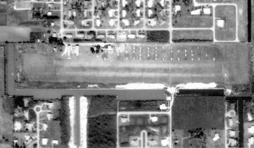
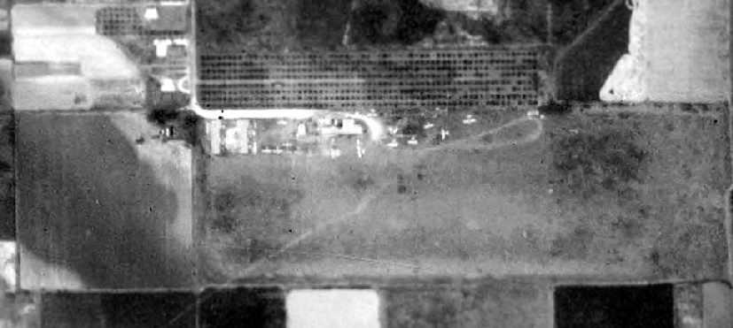
On the 12/27/63 USDA aerial photo (courtesy of the FL DOT, via Brian Rehwinkel)
a total of at least 42 aircraft were visible on the airfield.
However, in contrast to the 1952 photo, you can see the airport had been completely surrounded by urban growth,
which would eventually lead to its closure.
"Aero Country Club", as depicted on the 1963 FDOT General County Road Map of Dade County
(courtesy of the U of FL Smathers Library, via Brian Rehwinkel).
"Aero Country Club" was described on the Aerodromes table of the September 1964 Miami Sectional Chart (according to Chris Kennedy)
as having a single 2,640' turf runway.
The remarks said, "Aircraft over 600 hp prohibited."
The 1964 Miami Local Chart depicted Aero County Club as having a 2,600' unpaved runway.
Brian Wilson recalled, “Browns Airport / Aero Country Club... I flew out of that field on many occasions in 1964-65.”
The last depiction which has been located of the Aero Country Club Airport was on the April 1965 Miami Sectional Chart.
It depicted Aero County Club as having a 2,600' unpaved runway.
Brian Wilson recalled, “Browns Airport / Aero Country Club... My last logbook entry shows 8/1/65.”
Bruce Leary recalled, "Dade County was growing & the area around the airport was becoming suburbia.
The people who bought houses around the airport wanted the airport to go away.
After a couple more years fighting the county bureaucracy
the Howe's finally tossed in the towel & sold the airport to a housing developer.
They moved their business to the county-run Tamiami Airport but things were never the same."
The Aero Country Club was no longer depicted at all on the March 1966 Miami Sectional Chart (according to Chris Kennedy).
By the time of a 1969 aerial photo, the Brown's Airport site had been densely redeveloped with housing,
and not a trace appeared to remain of the little airport.
A 2017 aerial view showed not a trace appears to remain of Brown's Airport.
The site of Brown's Airport is located south of the intersection of Southwest 72nd Avenue & Southwest 107th Terrace.
____________________________________________________
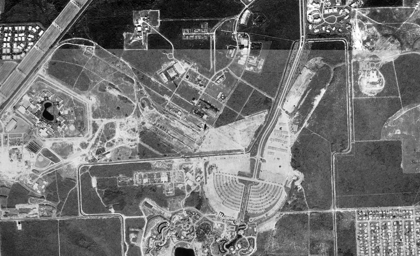
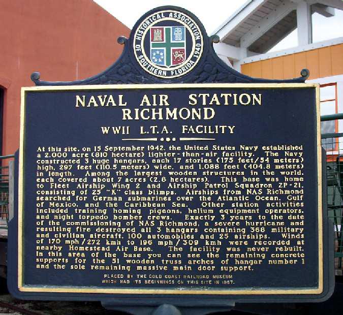
Richmond Naval Air Station, Richmond Heights, FL
25.62, -80.39 (Southwest of Miami, FL)
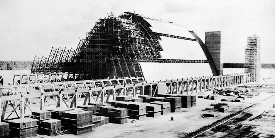
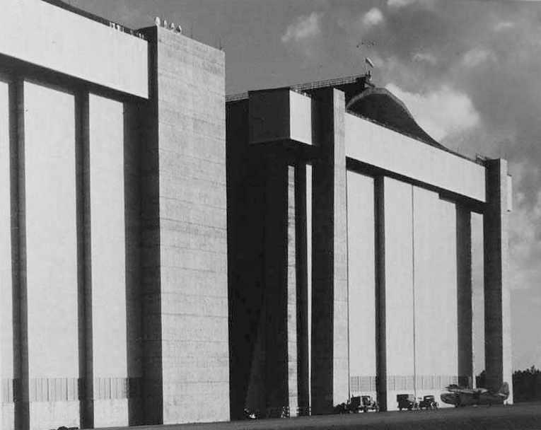
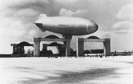
A circa 1941-42 photo of a massive NAS Richmond blimp hangar under construction.
Nothing was yet depicted at this location on a 1940 aerial view.
The Navy purchased 2,107 acres at this location in 1941 to construct a blimp base
to provide protection for Florida area shipping from German submarines.
The earliest photo which has been located of NAS Richmond
was a circa 1941-42 photo of a massive blimp hangar under construction.
NAS Richmond was commissioned in 1942,
and was at the time one of the largest construction projects to ever have been undertaken in Dade County.
The Richmond airfield was not yet depicted on the January 1943 Miami Sectional Chart (courtesy of Chris Kennedy).
According to a brochure from the Gold Coast Railroad Museum (courtesy of Richard Ochampaugh),
"The first airship, K-46, occupied Hangar #1 on 6/9/43. Hangars #2 & #3 were completed & in use shortly thereafter."
The earliest aeronautical chart depiction which has been located of the Richmond airfield
was on the August 1943 Miami Sectional Chart (courtesy of Chris Kennedy).
In 1943, one of Richmond's blimps detected a sub via radar.
It made a depth charge run on the sub, but was hit by anti-aircraft gunfire, and crashed into the sea.
This was the only blimp lost to enemy action in US waters during the war.
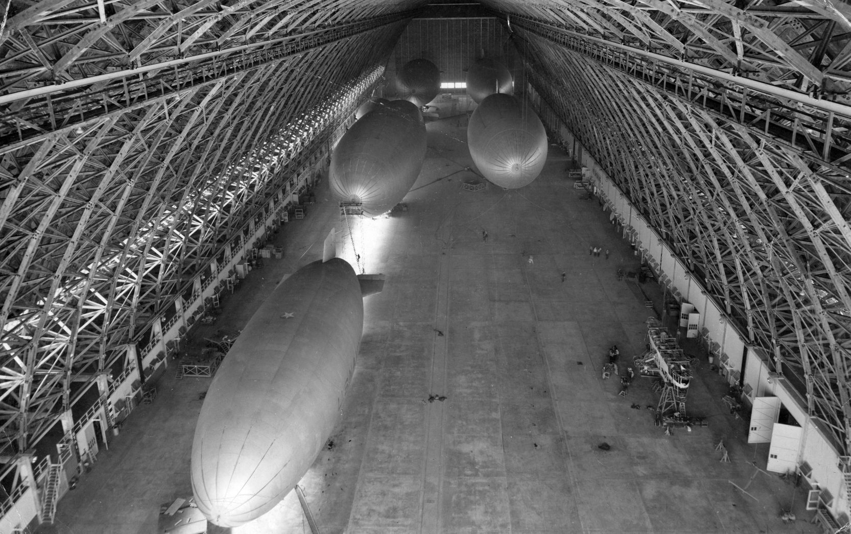
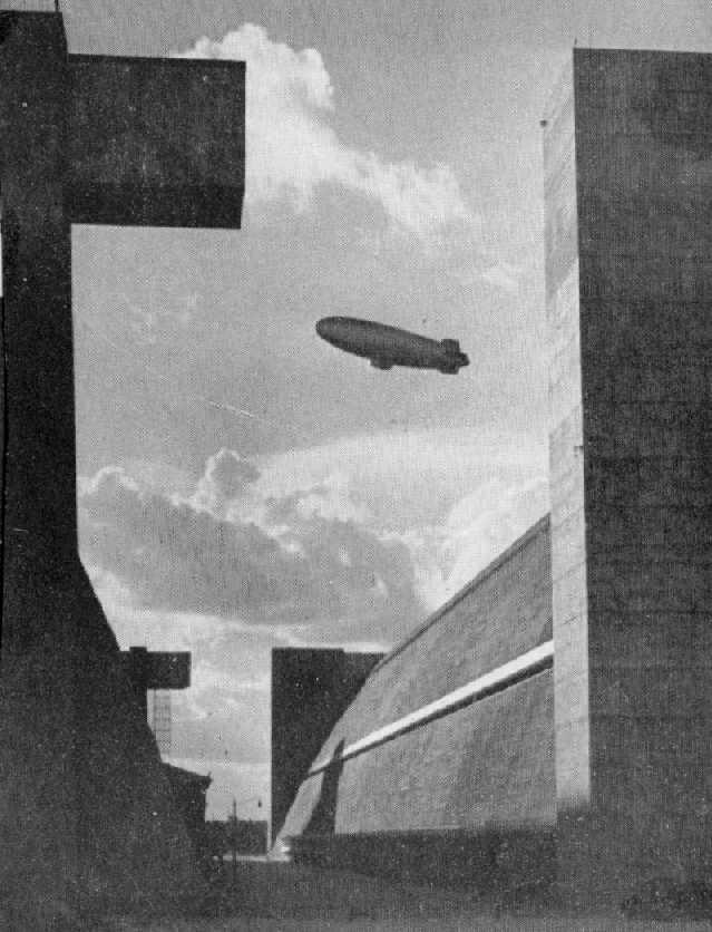
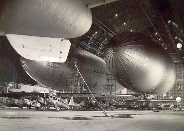
A circa 1943 view of the interior of the massive NAS Richmond blimp hangar, showing 5 Navy blimps & a blimp gondola undergoing maintenance (at lower right).
A WW2-era view of Richmond, looking west (National Archives photo).
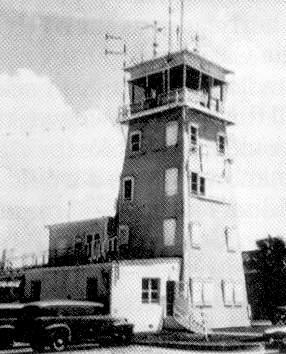
A circa 1940s photo of the NAS Richmond control tower.
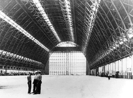
The interior of one of the Richmond blimp hangars, while under construction.
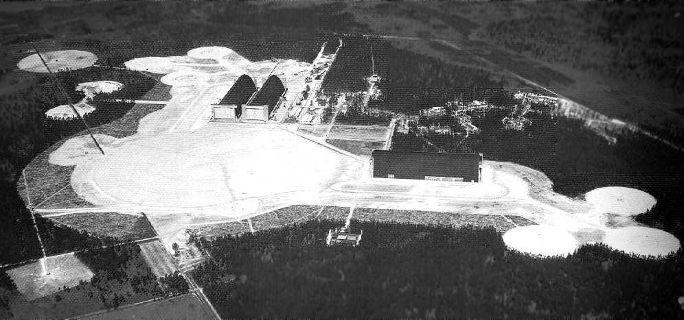
At its wartime peak, Richmond was home to 25 K-series blimps,
a 2,000' diameter landing mat, eight circular concrete mooring pads, 2 runways,
3 huge blimp hangars, a helium plant, and 3,000 men.
The station eventually became the largest blimp base on the east coast.
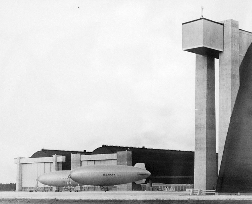
A 1943-45 photo of 2 Navy blimps in front of the massive NAS Richmond hangars (courtesy of Mike Legeros).
A circa 1943-45 photo of 2 of Richmond's massive blimp hangars.
Note what appears to be a Grumman amphibian (A Wigeon?) at the bottom-right.
Richmond's 3 blimp hangars were massive: 1,086' long & 183' high, with an interior floor space of 7 acres apiece.
According to a brochure from the Gold Coast Railroad Museum (courtesy of Richard Ochampaugh),
"Four massive concrete door supports located at the corners of Hangar #1 were 148' high.
They were one-of-a-kind, huge, thick columns.
The 51 parabolic wooden trusses in each of the 3 hangars contained approximately 2 million board-feet of Oregon Douglas Fir."
From November 1943 to May 1945, Richmond's blimps logged 730 continuous days on patrol.
This was a record untouched by any other Navy airship squadron.
As a result of these unrelenting patrols, the number of successful enemy torpedo attacks in the South Florida area
were reduced from 1942's total of 114 to only 4 sinkings in 1943.
A WW2-era photo (courtesy of Dorothy & Arthur Menser via Donna (Menser) Sterrett) from the Richmond LTA News,
originally captioned “K-ship circling the field before landing.”
“Richmond (Navy)” was depicted on the January 1944 Miami Sectional Chart (courtesy of Chris Kennedy)
as a military airfield, also with a dirigible mooring mast.
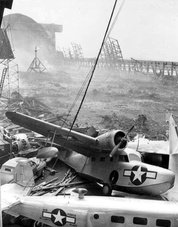
An undated photo showing Navy blimps looming over several civilian single-engine aircraft inside a massive NAS Richmond blimp hangar, presumably seeking shelter from the 9/15/45 hurricane.
NAS Richmond survived the Second World War without a scratch, only to be dealt a fatal blow not long thereafter by Mother Nature.
On 9/15/45, 3 years to the date of the base's commissioning, Richmond was devastated by a direct hit from a hurricane,
with 123 mph winds striking the massive blimp hangars.
Military aircraft - Grumman F6F Hellcats, Corsairs, and P-51 Mustangs, among others -
had been flown from nearby bases & from the deck of the USS Guadalcanal
to the refuge which was thought would be offered by NAS Richmond's sturdy & cavernous blimp hangars.
Unfortunately, the storm came directly through Richmond NAS.
The hangars, which stood close together, withstood the winds.
But one of them caught fire, perhaps from a short circuit.
Witnesses reported seeing the winds drive flames horizontal, and eventually all 3 hangars were ablaze,
lighting the night sky with burning wood, aircraft, and fuel.
It was the largest fire in the United States in 1945.
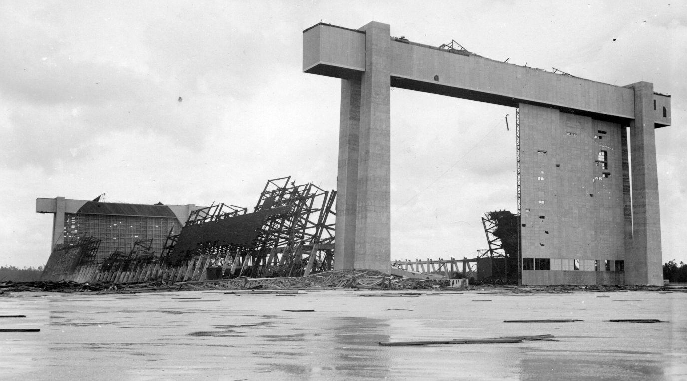
When the rain stopped, all 3 of the massive hangars were completely gone,
with only the smaller buildings & the hangars' concrete corner pillars still standing.
With the war over, the massive hangars would not be rebuilt.
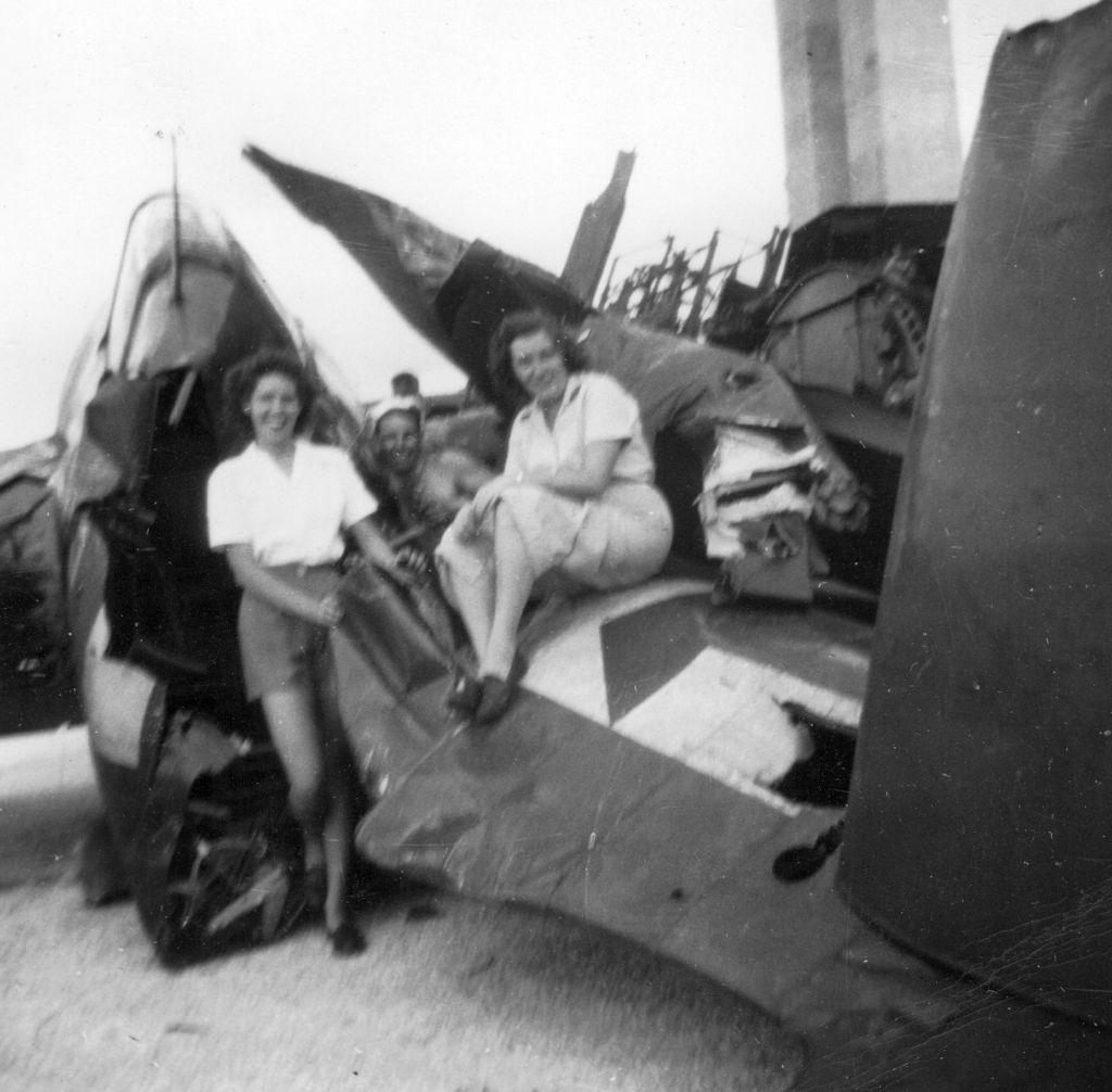
A September 1945 photo of Helen Kreason Mace (standing) & 2 other personnel (courtesy of Don Mace) on a wreck aircraft inside the NAS Richmond blimp hangar.
Don Mace reported, “My mother was a WAVES stationed at the Richmond airfield before the hurricane destroyed it.”
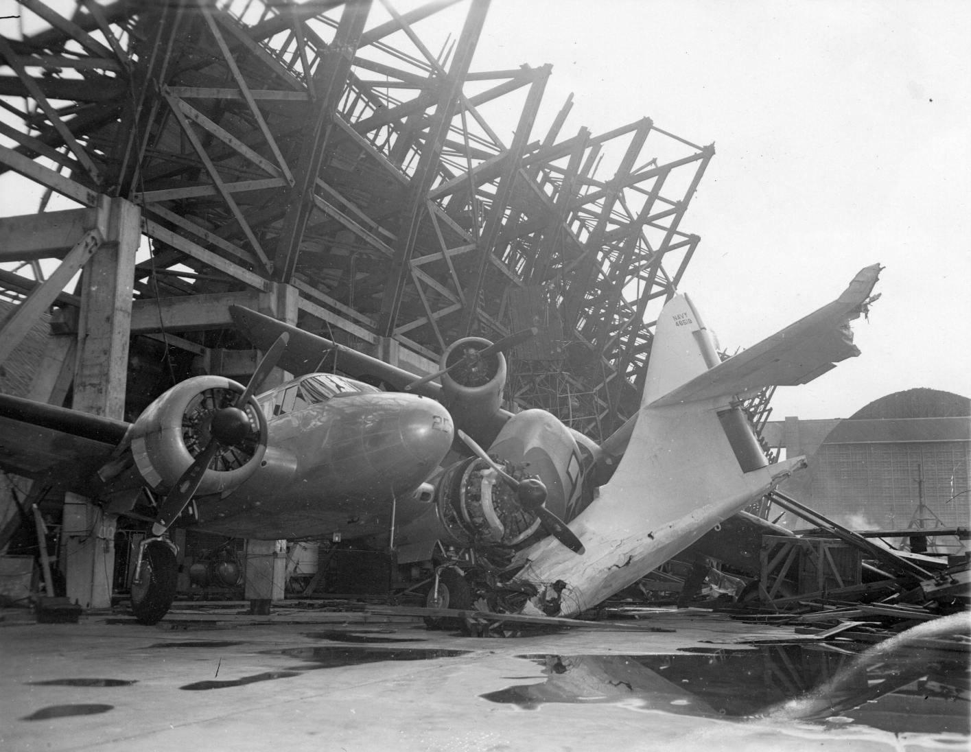
Wreckage of numerous aircraft at Richmond NAS in 1945,
with the remains of the blimp hangar in the background.
A September 1945 photo by Helen Kreason Mace (courtesy of Don Mace) of the post-storm wreckage of aircraft inside the NAS Richmond blimp hangar,
including a Beech SNB Kansan, Consolidated PBY Catalina, and a Grumman JRF Goose.
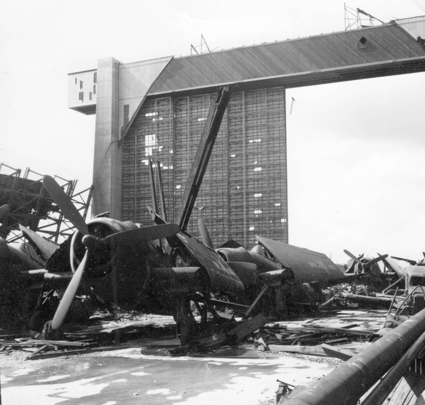
A September 1945 photo by Helen Kreason Mace (courtesy of Don Mace) of the post-storm wreckage of Grumman F6F Hellcats inside the NAS Richmond blimp hangar
A September 1945 photo by Helen Kreason Mace (courtesy of Don Mace) of the post-storm remains of the NAS Richmond blimp hangar
Ruth Mullis recalled, “In the fall of 1945 the Miami area was readying for a very dangerous hurricane.
I was on the field checking out planes as they left Brown's Airport, heading to Richmond Naval Air Base.
At this airport there were 3 huge blimp hangars, [for] which the base had already been contacted by local airports & were approved of the flying to there to store their small planes for the duration of the storm.
The huge blimps were up against the roofs of the hangars so there was plenty of room for the planes, which were placed nose to the floor & tail toward the roof.
Using that pattern they could stack hundreds of planes in those 3 hangars.
Another pilot flew my plane there as I was needed at our airport to list all the planes flying out & their owners.
The person in charge of safekeeping of the hangars knew nothing about hurricanes & ordered all 3 hangars closed up tight. Wrong!
The leeward wind side should have all windows open to relieve the pressure that builds up in an entirely closed-up building during a hurricane.
Yes the pressure built up in all 3 buildings & they all exploded, causing the blimps to fall down on all those planes, starting huge fires in the 3 hangars & totally burning them all to a crisp.
That is how I lost my 'cute little plane'. Indeed there were very few pilots around Miami who owned a plane after that storm & private planes back then were not insurable.
Also, if you were brave enough to fly one, you couldn't even get life insurance on yourself.”
A K-Type airship over the remains of the Richmond hangars in 1945.
Blimps never returned permanently to Richmond after the storm, but the base's helium plant continued to supply Navy airships for years.
Richmond's other buildings served a variety of uses, such as providing space for Naval & Marine Corps Reserve units.
In 1946, 1,571 acres of the Richmond base were deeded to the University of Miami, to be known as "South Campus".
It appears as if the Richmond airfield may have gone through a brief period of reuse as a civilian airfield,
as the August 1947 Miami Sectional Chart (courtesy of Chris Kennedy)
depicted “Richmond” as a civilian airport, without any indication of military use.
The field was depicted as having a 2,000' hard-surface runway.
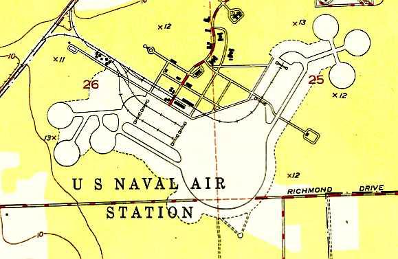
The 1949 USGS topo map depicted the Richmond “US Naval Air Station”.
A 3/4/52 USGS aerial photo depicted the abandoned NAS Richmond blimp base, with the concrete columns of the 3 massive former blimp hangars still standing.
“Richmond ALF (Navy)” was depicted on the August 1954 Miami Sectional Chart (courtesy of Chris Kennedy) as having a 4,000' unpaved runway.
The Aerodromes table on the chart described as the field as "Closed to all operations. ALF to NAS Key West."
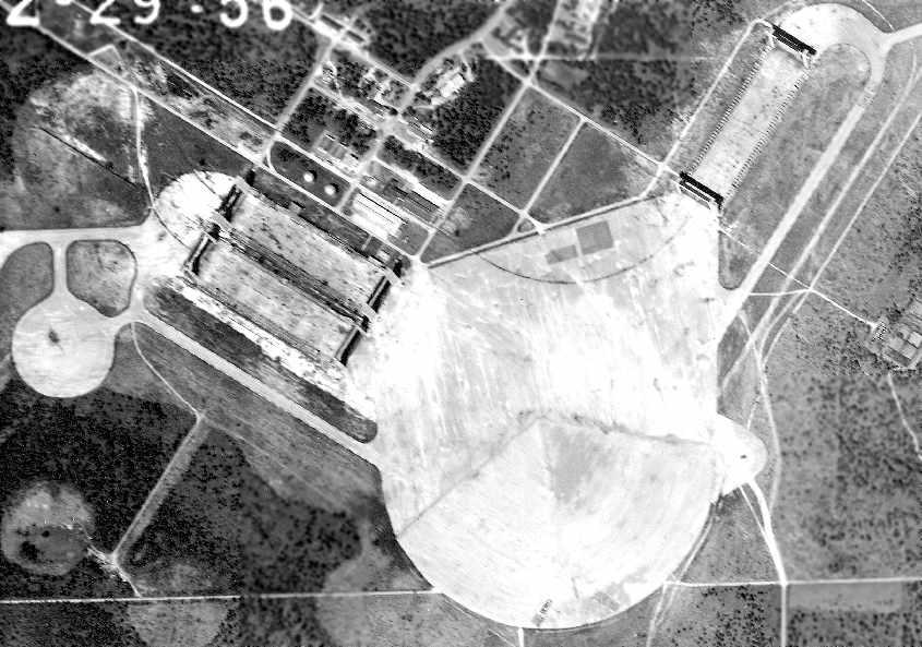
A 2/29/56 USDA aerial view of the former NAS Richmond (courtesy of the FL DOT, via Brian Rehwinkel).
Note that all of the former blimp hangar support columns were still standing.
According to former Miami resident Michael Willis, Richmond was also used as a convenient filming location for automobile commercials.
Mark Lincoln recalled of Richmond's blimp hangar, “An attempt was made to remove one of Hangar #3's supports with dynamite in the late 1950s or early 1960s but it failed.”
According to Thomas Page, in 1962 the Richmond Air Force Station (Z-210), a radar facility,
was constructed to the northwest of the former blimp airfield, consisting of 3 radar towers.
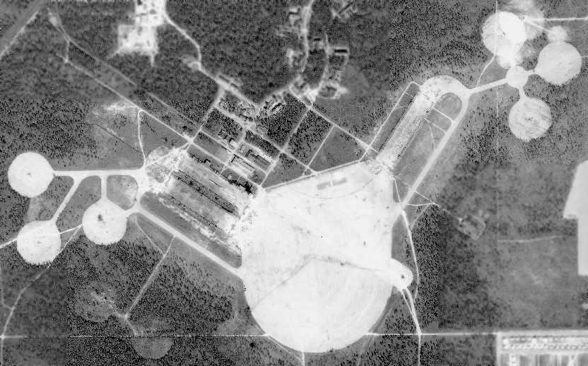
A 12/27/63 USDA aerial view of the former NAS Richmond (courtesy of the FL DOT, via Brian Rehwinkel).
Note note the large number (at least 10) of smaller blimp mooring circles scattered around the base.
Starting in 1962 the former NAS Richmond was reused in a curious role.
The CIA leased a few buildings from the University of Miami under the "front" name of Zenith Technological Services.
This "front" company was in fact the intelligence gathering headquarters for efforts against the Cuban communist government,
known as JM/WAVE, aka JM WAVE, aka WAVE STATION.
Over 400 CIA operatives operated out of this facility.
Strangely, the Richmond airfield was not depicted at all on the 1962 Miami Local Aeronautical Chart (courtesy of Jonathan Westerling) or the 1964 Miami Local Aeronautical Chart,
which instead merely depicted “Bldgs” at the site.
The last aeronautical chart depiction which has been located of the Richmond facility
was on the March 1966 Miami Sectional Chart (courtesy of Ron Kunse).
Curiously it depicted “Richmond” as a private airfield having 2 paved runways, the longest being 4,000'.
This “private” airfield designation may have been a reflection of the Richmond facility's use during this timeframe by a CIA front “company”.
Mark Lincoln recalled of Richmond's blimp hangar, “The door columns were still there in the late 1960s.”
In 1968 the CIA facility moved from Richmond to North Dade County.
Mark Lincoln recalled of Richmond's blimp hangar, “The door columns were were present in 1978 after the CIA pulled out.
I remember vividly driving around the mooring circles, through the Hangar door arches, and down the length of the hangars in a 1970 Duster.
The door supports were not destroyed until the new Dade County Zoo was constructed circa 1980-82.
Seven of 8 door supports were removed to build the Zoo circa 1980-82. ”
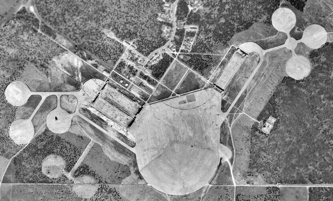
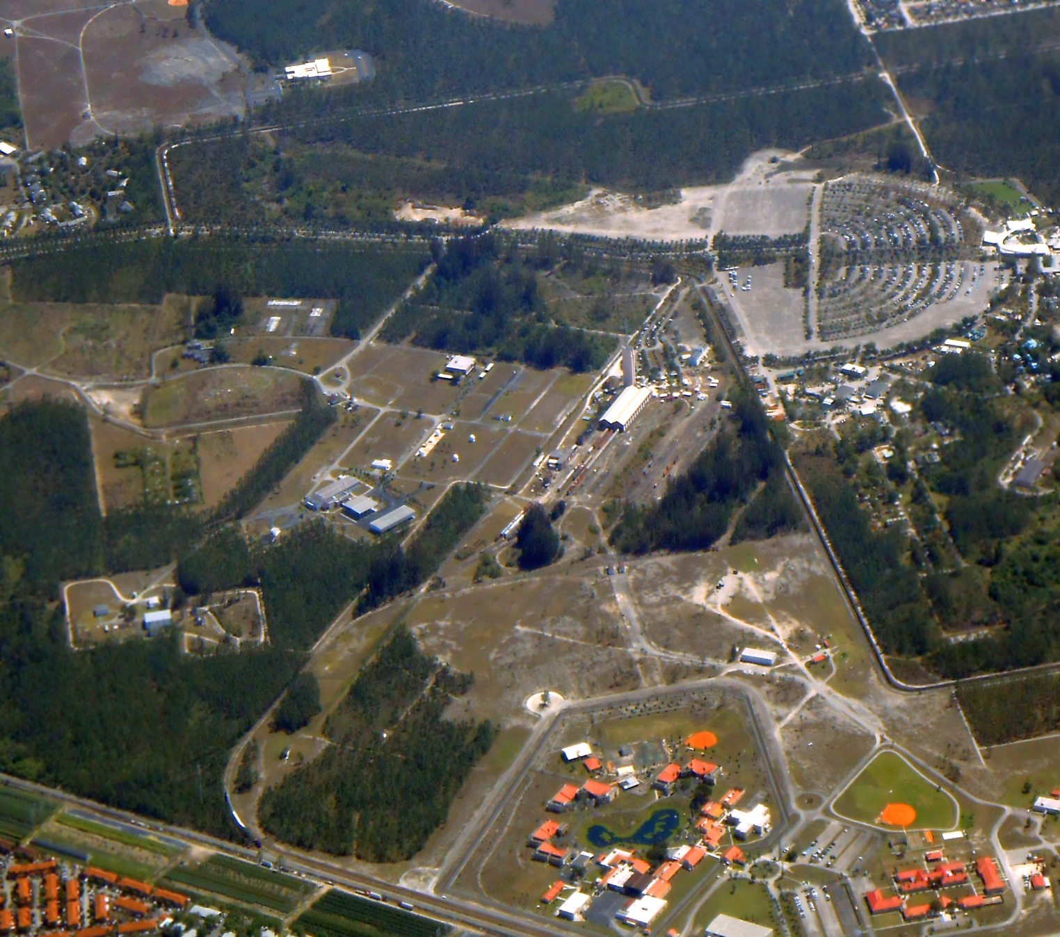
A 1986 aerial view showed that the huge southern blimp pad
had been reused for automobile parking for the adjacent Miami MetroZoo.
According to Thomas Page, the Richmond Air Force Station radar facility remained in operation by the FAA
until destroyed by Hurricane Andrew in 1992.
According to Charles LaBow, “Most of the original buildings survived Hurricane Andrew in 1992,
but were later removed by the U.S. Army Corps of Engineers for ongoing projects
currently existing on the 'Federal Government' side of the property, controlled by the Army & the Department of State.”
A 1994 aerial view of the site of NAS Richmond showed the central blimp mooring pad was still recognizable,
along with portions of 3 smaller blimp mooring circles on the northeast side.
The Richmond property was labeled on 1990s USGS topo maps as a "US Coast Guard Communications Station".
The efforts to save the Richmond base were chronicled in the 8/01 issue of Smithsonian Air & Space Magazine.
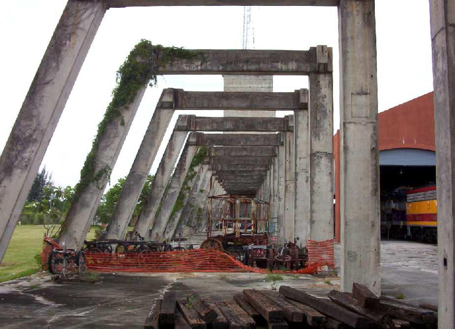
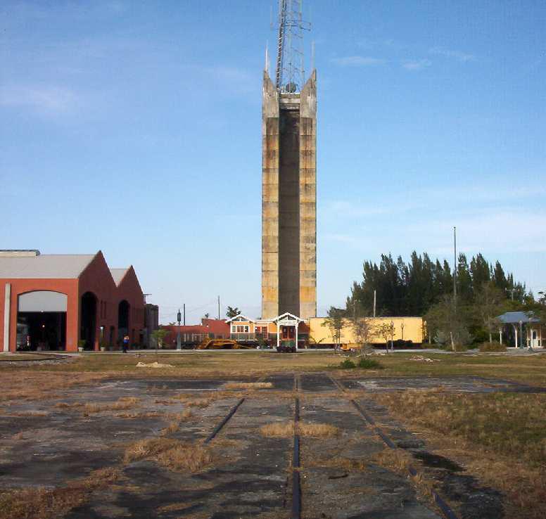
A 2003 photo by Robert Ochampaugh of the only portion of the former blimp hangar which remains standing, its concrete framework.
A 2003 photo by Robert Ochampaugh, "standing in what would be the rear of Hangar 1.
I tried to capture the sheer size of just the hangar bay as you can see the hangar still went to the left another 50 ft & to the right about another 100+ ft.”
Robert observed that there are still burn marks on the concrete floor of Hangar 1, which "are still black even after 60 years of South Florida sun & rain."
A 2003 photo by Robert Ochampaugh of Richmond's boiler room, which supplied power to open & close the huge hangar doors.
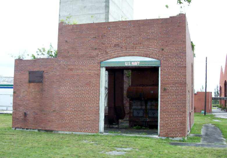
A 2003 photo by Robert Ochampaugh of the historical marker at the NAS Richmond site.
A 2003 photo by Robert Ochampaugh of the tracks on which the doors of Hangar 2 used to move,
along with the concrete tower which remains from the hangar.
The pillar is now one of the highest structures in southern Dade County.
Bristling with antennas, it is used as the central relaying station for the area's 911 service.
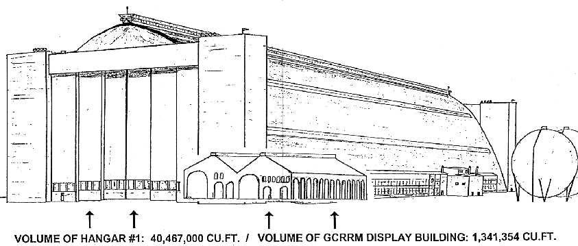
A diagram from a brochure from the Gold Coast Railroad Museum (by John McLean)
which contrasts the size of the remaining building at the Richmond site (in the center)
with the tremendous size of the blimp hangar which used to occupy the site.
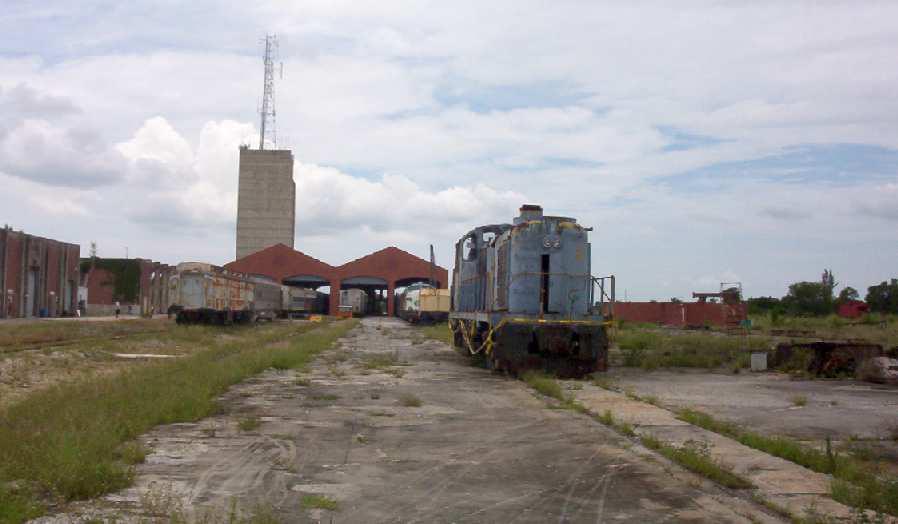
Charles LaBow reported in 2005 that “All of the preservation functions of NAS Richmond
are maintained by the members of the Gold Coast Railroad Museum.
The Museum also maintains an on-site exhibit of NAS Richmond history,
which is included with Railroad Museum admission.”
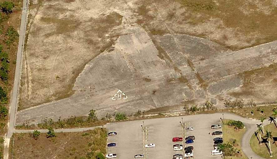
A circa 2006 aerial view looking north at what appears to be the last remaining aviation infrastructure at the site of NAS Richmond:
a helipad painted on one of the remaining asphalt blimp mooring circles, on the northeast corner of the former base.
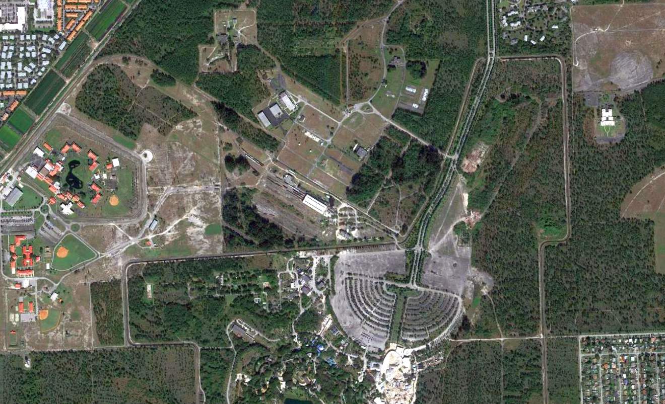
A 2016 aerial view of the site of NAS Richmond showed the central blimp mooring pad was still recognizable,
along with portions of 3 smaller blimp mooring circles on the northeast side.
A 3/4/18 aerial view by Alex Price looking east at the remains of NAS Richmond.
Alex noted, “You can still make out where the launch/landing pads for blimps were.”
____________________________________________________
25.638, -80.29 (South of Miami International Airport, FL)
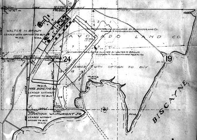
A 1918 survey diagram of the Cutler Aerial Gunnery Field, later renamed Chapman Field.
This World War One military airfield was located along the shore of Biscayne Bay.
A total of 850 acres of scrubland were acquired by the Army in 1917 along the shore of Biscayne Bay
to establish the Army Signal Corps' Cutler Aerial Gunnery Field.
During 1918, the army subsequently dredged a portion of the bayside marsh to create a landing field,
a lagoon for water landings, and channels to Biscayne Bay.
Initial construction at the base was completed in 1918. The first commander was Captain William Pedrick.
An article in the 8/20/18 Miami Metropolis described the "deluxe conditions"
awaiting the fliers who would come to the school to finish their training in gunnery practices.
The camp was a model town with electricity, waterworks & a sewage system.
Constructed on a rock ridge, the base buildings were situated among pine trees & had a view of the bay to the east.
Officers' quarters & mess halls & the home of the commanding officer
were built around an oval field higher up & perpendicular to the original Ingraham Highway
(which had been relocated to the station's perimeter & would in succeeding years be renamed Old Cutler Road).
A row of hangars sat along the western edge of the filled landing field just east of a road parallel to Ingraham Highway
on which were situated maintenance shops & the headquarters building.
Off to the side of the station a target range had been dug out of the rock.
In late 1918 the airfield was formally renamed the Victor Chapman Military Reservation.
The First World War ended a mere 3 days after the renaming ceremony,
and construction at Chapman Field Military Reservation ceased.
The base was declared surplus in 1921 by the War Department & offered for sale,
but a clear title could not be conveyed, and the sale was canceled.
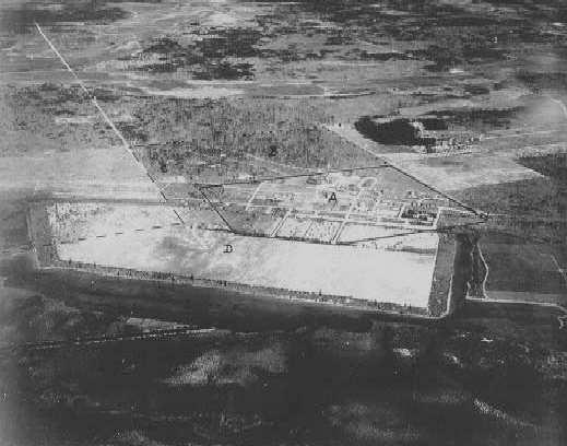
A 1931 aerial view of looking west-northwest at Chapman Field.
Subsequently a notice was received at the US Department of Agriculture that the property was to be abandoned.
The Secretary of War gave a portion of Chapman Field to the USDA under a revocable lease agreement,
to establish an agriculture laboratory.
On a portion of the remaining land outside the USDA station
the government maintained an airfield used by Army reservists
who practiced bombing runs over Biscayne Bay during the winter months.
Local antagonism to this airfield was led by Col. Robert Montgomery, a neighbor on Old Cutler Road,
who joined in the continuing effort to have all the property released to the USDA.
During the Depression years, however, other interests in Miami were hoping the War Department
would develop a major air facility on the site, which would provide a considerable number of new jobs.
Congressman Mark Wilcox led the effort to get an expanded airfield built at Chapman Field,
but he was thwarted by USDA interests at nearly every step.
Montgomery, especially, recently retired from the U.S. Army, had special access to military planners.
Most of these men already believed that Chapman Field was unsuitable for the modern aircraft of the time
and that its proximity to urbanized areas was a serious detriment.
Although Congressman Wilcox pushed legislation in 1933 for an $11 million expansion of Chapman Field,
no changes actually appeared.
The 1934 Department of Commerce Airport Directory (according to Chris Kennedy)
described "Chapman Field, Army" as having a coral, sand, and clay rectangular landing area, measuring 3,900' x 1,300'.
A 1936 photo showed an Army biplane (type unidentified) with the runways of Chapman Field in the background.
The original caption read, “Landing field was thoroughly graded, stones removed, runways extended & grass planted by FERA project 13-289.”
The December 1935 Miami Sectional Chart (courtesy of Chris Kennedy) depicted Chapman as a military airfield.
The November 1936 "Official Airway Map of FL" (courtesy of Chris Kennedy) depicted Chapman Field as having 3 runways.
The Airport Directory Company's 1937 Airports Directory (courtesy of Bob Rambo)
described Chapman Field as having a rectangular 3,900' x 1,300' coral sand landing surface.
The aerial photo in the directory depicted a hangar on the west side of the field, which had "Chapman Field" painted on the roof.
The April 1937 Miami Sectional Chart (courtesy of Chris Kennedy) depicted Chapman as a military airfield.
A 1938 USDA aerial photo of Chapman Field, from the Digital Library Center / University of FL Smathers Libraries.
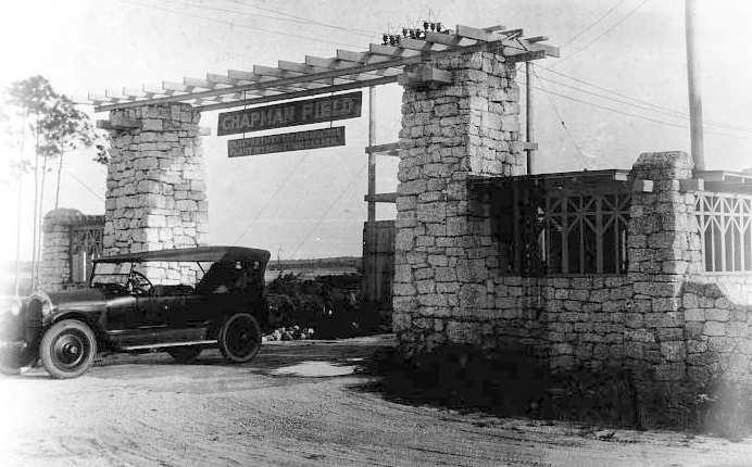
A circa 1930s-40s view of the entrance gate to Chapman Field at Old Cutler Road.
The gate was demolished by the USDA in the late 1950s.
In 1939 a false report of Chapman Field's abandonment was printed in the Miami Daily News.
Still, it was hard for the War Department to part with the property.
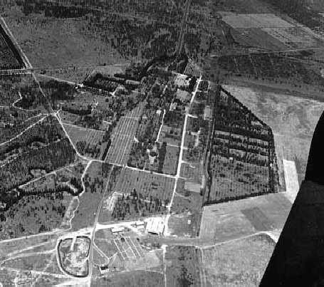
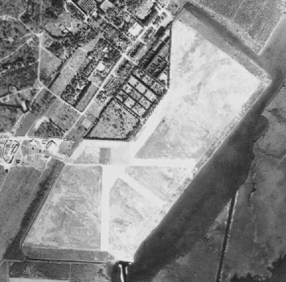
A 1940 aerial view looking north-northwest at Chapman Field.
A 1940 aerial photo showed Chapman Field having 4 short runways.
According to Joe Benson, the runways at Chapman Field were never paved,
but consisted of crushed & rolled coral rock.
The May 1941 Miami Sectional Chart (courtesy of Chris Kennedy) depicted Chapman as a military airfield.
In the autumn of 1941 the War Department was finally set to accept a transfer of title to the USDA,
but the onset of WW2 put everything on hold.
During the war years the USDA station continued to operate,
and the property was used at times by the military for survival training.
With the onset of American involvement in WW2, the military began to use tourist areas for training programs
because these areas had become financially depressed as tourism & college enrollment declined due to war.
Miami's Chapman Field was reactivated with the advent of WW2, but proved too small for modern military planes.
In 1942, the Army air facilities at Chapman Field were made available to the Embry-Riddle Corporation,
which was contracted to train civilian & military pilots.
Civilians, including potential WASPs (Women's Air Force Service Pilots),
were taught at the Seaplane Base on MacArthur Causeway (named County Causeway until 1942),
while written exams & Navy flight training were conducted at Chapman Field.
Women seeking additional flying time for WASP approval also took training at Chapman Field.
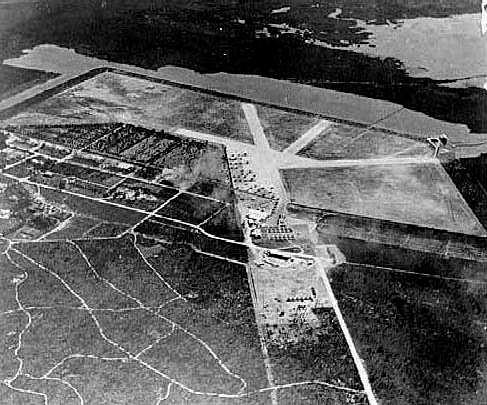
A WW2-era aerial view looking east at Chapman Field.
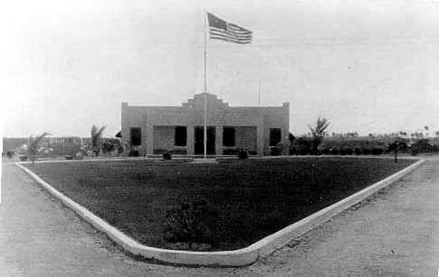
A WW2-era view of Chapman Field's Administration Building.
Chapman was depicted as a civil airfield on the 1943 Miami Sectional Chart (courtesy of Chris Kennedy).
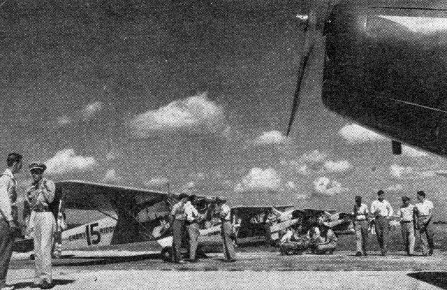
An undated photo several Piper J4 Cubs at Chapman Field from the 3/10/44 Embry-Riddle “Fly Paper” (courtesy of Lisa Stanford).
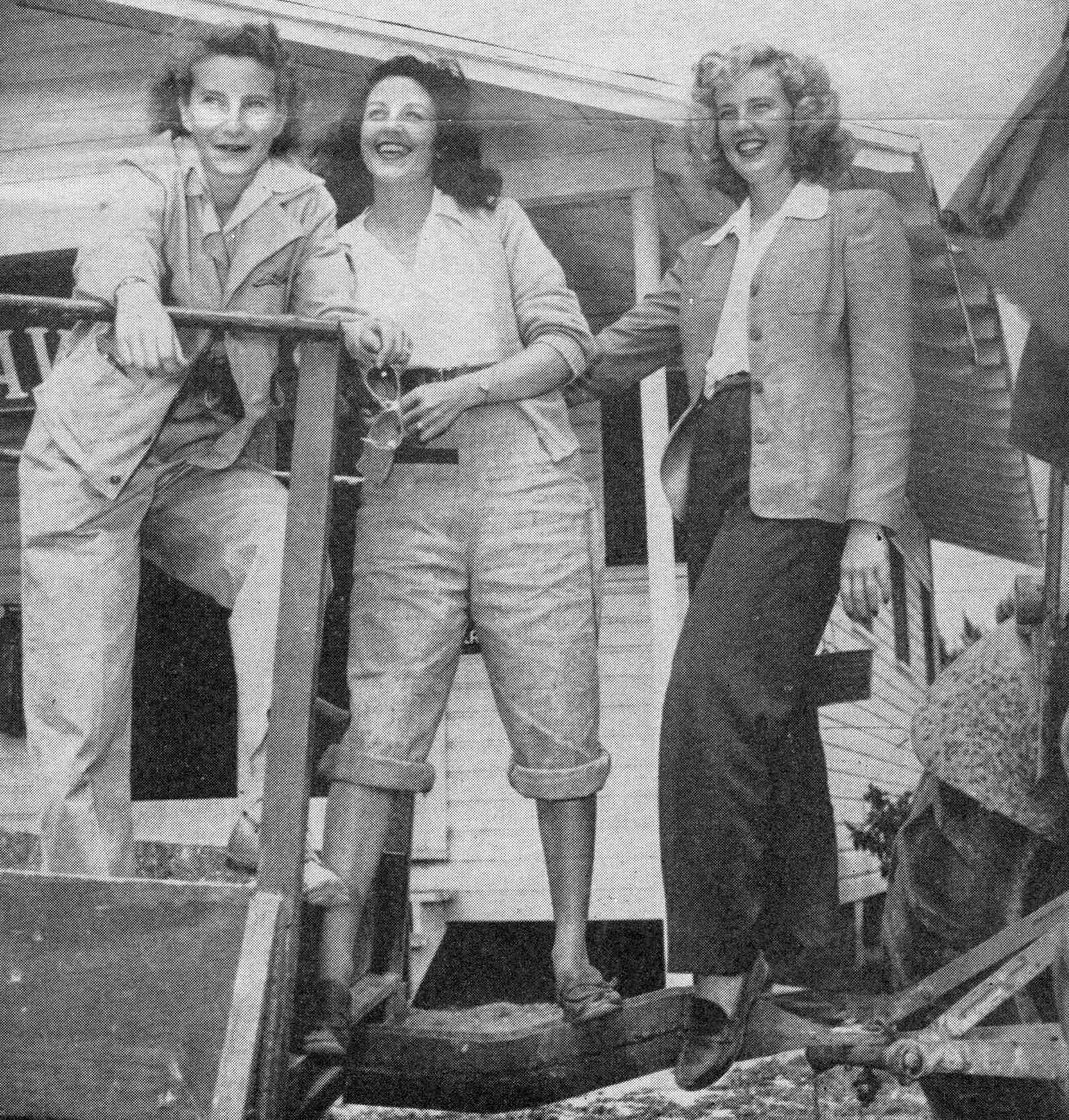
An undated photo of women flight students at Chapman Field from the 3/24/44 Embry-Riddle “Fly Paper” (courtesy of Lisa Stanford).
The photo was captioned, “Young air-minded America comes to FL from VA, LA, and NY to learn to fly at Chapman Field.
At the left is Virginia Worley of VA, next is Carol Jackson of NY, and Betty Stevens of LA.”
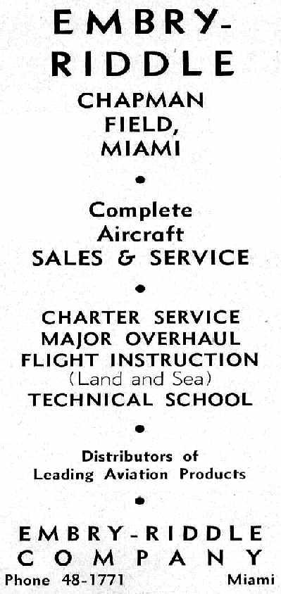
An advertisement for Embry-Riddle at Chapman Field,
from the Haire Publishing Company's 1945 Airport Directory (courtesy of Chris Kennedy).
With the end of the war, the GI Bill of Rights made available technical training to returning vets,
and a contract was given to Embry-Riddle to provide training based at Chapman Field.
The Haire Publishing Company's 1945 Airport Directory (courtesy of Chris Kennedy)
described Chapman Field as being owned by the U.S. Department of Agriculture,
and operated by the Embry-Riddle Company.
The airfield was described as an all-way sod field, measuring 4,000' northeast/southwest by 2,500' east/west.
Chapman Field was depicted on the August 1947 Miami Sectional Chart (courtesy of Chris Kennedy)
as having a 4,000' unpaved runway.
In 1947 a request was made by Embry-Riddle to make Chapman Field a commercial airport,
but this was denied by Dade County,
and the company eventually moved to Opalocka & the field was subsequently closed.
The last depiction which has been located of Chapman Field was on the 1950 USGS topo map.
It depicted Chapman as having 4 short unpaved runways.
By the time of the August 1954 Miami Sectional Chart (courtesy of Chris Kennedy), Chapman Field was no longer depicted at all.
A 1969 aerial view no longer showed any recognizable trace of Chapman Field.
As of 2002, although the area immediately surrounding the former Chapman Field property had been densely built up,
the property of the former airfield remained relatively undeveloped.
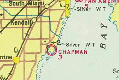
The USDA research station still occupies the former housing area of the airfield,
with the street grid still recognizable from vintage photos.
The area of the former runways has become a golf course - the Deering Bay Yacht & Country Club.
The former seaplane operating area along the shore of Biscayne Bay is now the Chapman Field Park.
A 2017 aerial view looking northwest shows no recognizable trace of Chapman Field.
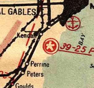
The site of Chapman Field is located southeast of the present-day intersection of SW 67th Avenue & Old Cutler Road.
Thanks to Joe Benson for pointing out Chapman Field.
See also: http://www.ars-grin.gov/ars/SoAtlantic/Miami/history/chaphist.htm
____________________________________________________
Since this site was first put on the web in 1999, its popularity has grown tremendously.
If the total quantity of material on this site is to continue to grow,
it will require ever-increasing funding to pay its expenses.
Therefore, I request financial contributions from site visitors,
to help defray the increasing costs of the site
and ensure that it continues to be available & to grow.
What would you pay for a good aviation magazine, or a good aviation book?
Please consider a donation of an equivalent amount, at the least.
This site is not supported by commercial advertising –
it is purely supported by donations.
If you enjoy the site, and would like to make a financial contribution,
you
may use a credit card via
![]() :
:
Please consider checking the box to make a monthly donatation.
For a mailing address to send a check, please contact me at: paulandterryfreeman@gmail.com
If you enjoy this web site, please support it with a financial contribution.
please contact me at: paulandterryfreeman@gmail.com
If you enjoy this web site, please support it with a financial contribution.
____________________________________________________
This site covers airfields in all 50 states.