Abandoned & Little-Known Airfields:
Western Connecticut
© 2002, © 2024 by Paul Freeman. Revised 3/8/24.
This site covers airfields in all 50 states: Click here for the site's main menu.
____________________________________________________
Please consider a financial contribution to support the continued growth & operation of this site.
Hamden Airport (added 12/26/20) - Jonnycake Airport / Mountain Meadow Airport (revised 3/8/24) - Monroe Airport (revised 1/18/22) - Norwalk Airport (revised 1/30/21)
____________________________________________________
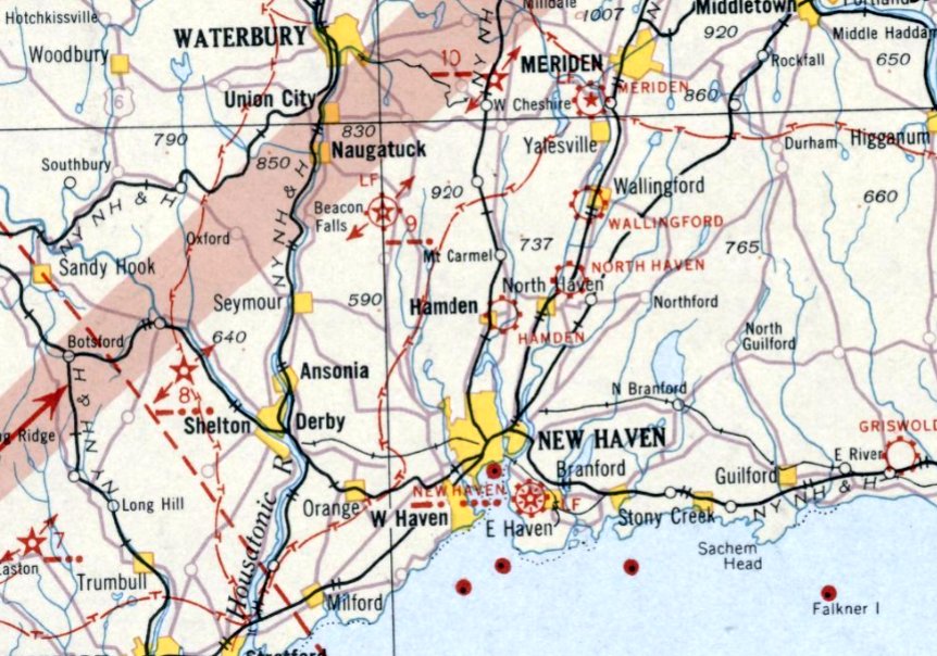
41.341,-72.931 (Northeast of New York, NY)
Hamden Airport, as depicted on the August 1932 NY Sectional Chart.
The date of establishment of this early small general aviation airport has not been determined.
The earliest depiction which has been located of Hamden Airport was on the August 1932 NY Sectional Chart.
Hamden Airport was not depicted on USGS topo maps from 1932/38/44.
According to a 2002 Environmental Assessment for Hamden Middle School (courtesy of Mark Carpentier),
“In the early 1930s, a small airport, known as the Hamden Airport, was present on the industrial park site.
The airport reportedly consisted of a 33-acre parcel, developed with 1 or 2 hangars & grassy landing fields.
The airport reportedly owned 6 planes & operations included plane maintenance as well as flights.”
The earliest photo which has been located of Hamden Airport was a 1934 aerial photo.
It depicted a single hangar on the south side of an irregularly-shaped grass field.
There were no aircraft visible on the field.
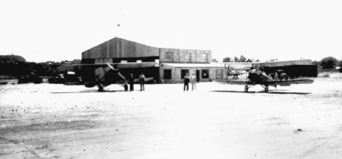
A circa 1930s photo of 2 unidentified biplanes in front of a hangar at Hamden Airport (courtesy of Bob Caplan).
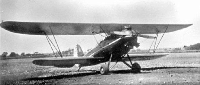
A circa 1930s photo of an unidentified single-engine biplane at Hamden Airport (courtesy of Bob Caplan).
The last aeronautical chart depiction which has been located of Hamden Airport was on the July 1934 NY Sectional Chart.
Hamden Airport was evidently closed (for reasons unknown) at some point in 1934,
as it was no longer depicted on the November 1934 NY Sectional Chart.
According to a 2002 Environmental Assessment for Hamden Middle School (courtesy of Mark Carpentier),
“The airport went out of business prior to 1936; the property was sold to the Evergreen Cemetery Association & subsequently resold as an industrial parcel.
In July 1937, the hangars were demolished.”
According to the Hamden Historical Society, the Ringling Brothers Circus performed on the Hamden Airport site for a number of summers prior to 1947.
A 1949 aerial photo showed the Hamden Airport property remained clear, but the hangar had been removed.
According to a 2002 Environmental Assessment for Hamden Middle School (courtesy of Mark Carpentier),
“The Hamden Industrial Park was developed in the 1980s.
Haley & Aldrich did not encounter evidence of activities on the airport site, other than recreational & circus use,
after the airport was closed & prior to construction of the industrial park.”
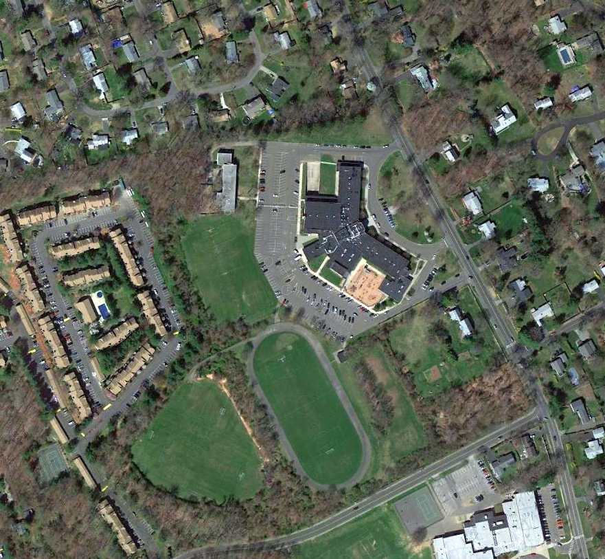
A 2019 aerial view showed no trace remaining of Hamden Airport.
Thanks to Mark Carpentier, Sandy Barker, and Bob Caplan for pointing out this airfield.
____________________________________________________
41.14, -73.42 (Northeast of New York, NY)
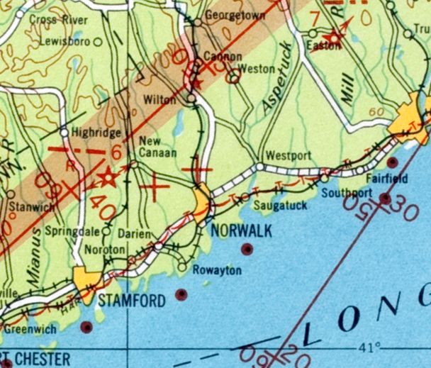
Norwalk Airport was depicted on the 1931 Air Navigation Map as an unlabeled auxiliary airfield (the read cross on the north side of Norwalk).
This small general aviation airport was evidently established at some point between 1929-31,
as it was not yet depicted on a 1929 aerial photo (courtesy of Thomas Cossuto).
According to Thomas Cossuto, “The Norwalk Airport was built for Dr. Alvin Wadsworth’s son because he was into aviation.”
According to Ray Jacobelli, “The Fodor's operated a machine shop during the 1920s.
I met a relative several months ago who told me one of the Fodor's was interested in starting an aircraft manufacturing business.
The son bought the Mutual Aircraft Company (Kansas City, MO) and the rights to manufacture the Mutual Blackbird biplane,
which was designed by Giuseppe Bellanca & one of the first to be constructed used a welded steel tube fuselage
The flight of the Blackbird to Norwalk occurred prior to the stock market crash of 1929.
Fodor flew the airplane back east, landing at Norwalk Airport, but ground looped & damaged the airplane.
The airplane was disassembled & trucked back to their farm.”
The earliest photo which has been located of Norwalk Airport was on the 1931 Air Navigation Map,
which depicted an unlabeled auxiliary airfield on the north side of the town of Norwalk.
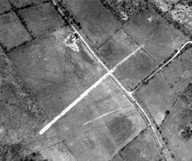
The earliest dated photo which has been located of Norwalk Airport was a 1934 aerial view.
It depicted Norwalk as having a single hangar on the north side of a grass airfield.
A northeast/southwest runway appeared to cross Rocks Road.
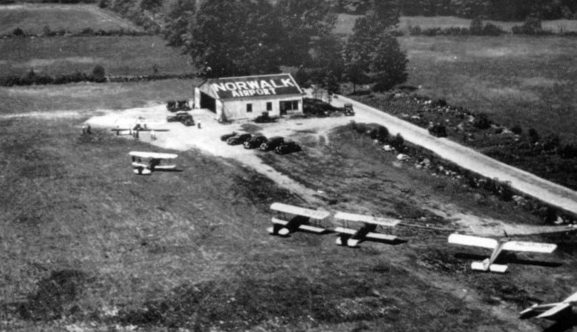
A circa 1930s aerial view depicted 6 single-engine aircraft next to a hangar labeled “Norwalk Airport”.
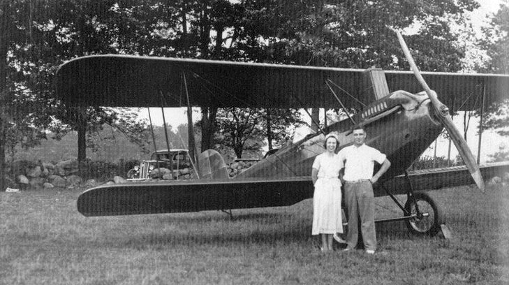
A circa 1930s photo of May & Bud Everson in front of a Swallow biplane at Norwalk Airport (courtesy of David Jaundrill).
According to Ray Jacobelli, “On 12/12/38, 2nd Lt. Lawrence Spillman was piloting a North American BC-1 aircraft, (serial #38-379) on a training flight over CT when he encountered thick cloudy weather.
The aircraft’s radio receiver wasn’t working properly, and with deteriorating conditions, he thought it wise to set down at the nearest airfield
rather than attempt to make it back to his home base of Mitchel Field on Long Island.
As he came in to land at Norwalk Airport, the aircraft hit a patch of soft ground & flipped over on its back.
Neither Lt. Spillman or his passenger, 2nd Lt. Leroy Stefonowicz, were injured.
The men were assigned to the 5th Bomb Squadron based at Mitchel Field, Long Island.”
The last aeronautical chart depiction which has been located of Norwalk Airport was on the March 1940 NY Sectional Chart,
which depicted Norwalk as a commercial/municipal airport.
According to Ira Perelle, Norwalk Airport “was used as an aircraft spotter's post early in the WW II years (to watch for the arrival of enemy aircraft).
I was in high school in those years, and volunteered as an aircraft spotter, which is how I learned of its existence.
There wasn't much on the field, just a grass strip & a few shacks, although old-timers told me that it had been active during the 1930s.”
The Norwalk Airport was evidently closed (for reasons unknown) at some point between 1940-41,
as it was no longer depicted on the October 1941 NY Sectional Chart.
The last depiction which has been located of Norwalk Airport was on the 1943 USGS topo map,
which depicted Norwalk Airport as an open area with a few small buildings along the periphery.
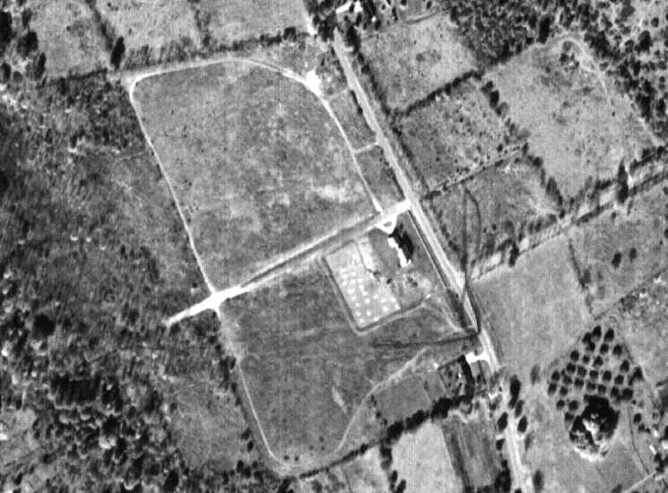
A 1951 aerial photo showed the remains of the Norwalk runway.
Kevin Daly observed, “The runway no longer crossed the road to the east but was extended through a farm's stonewall to the west.
The original building is gone & a new hangar is right next to the runway to its south.”
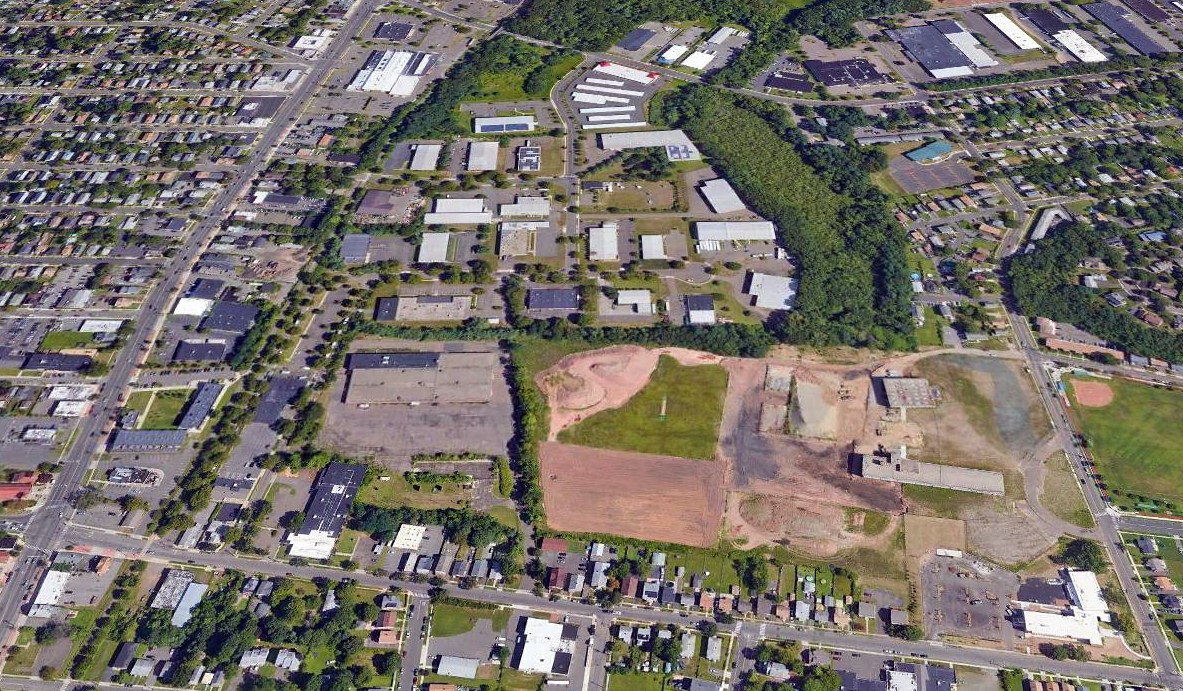
A 1960 aerial photo showed that the All Saints Catholic School had been built over the site of Norwalk Airport at some point between 1951-60.
A 3/9/12 aerial view shows All Saints Catholic School covering the site of Norwalk Airport.
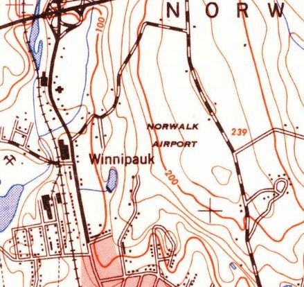
The site of Norwalk Airport is located northwest of the intersection of Aiken Street & West Rocks Road.
____________________________________________________
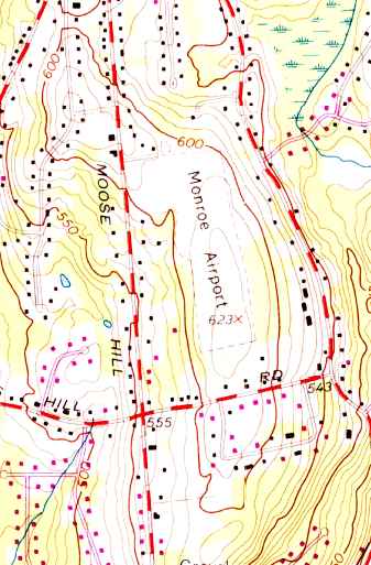
41.32, -73.2 (Southwest of Hartford, CT)
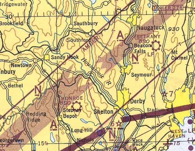
Monroe Airport, as depicted on the January 1945 NY Sectional Chart (courtesy of Ron Plante).
Kevin Daly recalled, “I grew up on Pamela Drive at the south end of Wheeler just beyond Cross Hill Road.
You could say that my location and a boyhood fascination with the Monroe Airport sort of define who I am even today.
Lois Hurd's grandfather, Ambrose Hurd owned & farmed the land where the airport would eventually be built.
The fields were once divided by stone walls from Moose Hill Road east to Wheeler Road & were filled with grazing dairy cows.
Ambrose died in 1929 from injuries he sustained from being kicked by a farm animal - either a horse or cow.
After Ambrose died his son Ben immediately sold off all the dairy cows.
He had absolutely no interest in farming whatsoever & had more contemporary ideas in mind.”
Kevin continued, “In the early 1930s there was a car race track practically at the intersection of what we know as Four Corners in Shelton.
This was a very successful venture during the early Depression years & Ben saw an opportunity to open a larger track in Monroe on the former farmland.
So what you know as the The Monroe Airport was once a thriving racetrack. Cars reached speeds of nearly 100 MPH.
And you thought Monroe was a quiet farming town. Not in 1934 it wasn't.
There were practically no trees across the entire town & the roar of finely tuned engines could be heard for miles.”
A 1934 aerial photo showed an oval racetrack on the property.
According to a local resident, “The track lasted for a few years & during this time Ben was taking flying lesson at Bridgeport Airport. He'd caught the flying bug.
The original airstrip was across the street, north of the Hurd's house (the large white house on Moose Hill across from the airport)
and ran all the way north to where the Monroe Firehouse is today - basically Hurd Avenue.
In the late 1930s tensions of war in Europe gave Ben another idea.
He would build an airport & teach pilots to fly should America become involved in the war.
One of Ben's jobs at this time was building roads & he had earthmoving equipment at his disposal.
So at night, he & his young daughter Lois would drive out into the field on a bulldozer with headlights
and dig long trenches across racetrack to bury all the stone walls which spanned the track's infield.
Once the trenches were dug they pushed the walls in & buried them.
You can still see those stone walls just beneath the surface in modern photographs today.”
Kevin Daly reported, “Ben Hurd opened the Monroe Air Service in 1940.”
According to a local resident, “The airport was opened in 1940.
Business was booming with the new venture & young Lois worked the gas pumps
and her mother sold hot dogs in the canteen attached to the main hangar.
But then the Empire of Japan attacked Pearl Harbor & we were in a World War.
Shortly thereafter the government closed all airfields which were within potential attacking distance of the coast.
So Ben moved the entire airport operation to New York State.”
Lois Hurd Hayden recalled, “Ben had the airport open only a short time when WW II began.
We had to have 24 hour guard, and we girls took turns sitting up with either Mom or Dad on duty. The folks didn't get much sleep.
At the time the hangar was being built & in the early morning hours, it looked like the studs & rafters were moving.
Then the government closed all airports within 50 miles of the coast on short notice.
A good many of the airports in Southern CT & NY moved their personnel and equipment to Stormville, Greenhaven, and Wappingers Falls, NY.
We were training guys & gals to get their licenses so they could enlist in the Air Force & have a step-up on other enlistees.
With so many airplanes in Stormville & the area, Ben contacted the leasee, Howard Maxson, of an airstrip in Wingdale, and moved our operation there.”
Monroe Airport was not depicted at all on the November 1942 NY Sectional Chart (courtesy of Ron Plante).
Lois Hurd Hayden recalled, “By Thanksgiving of 1942 Monroe Airport was in business at Wingdale & our family moved there for about 2 years.
During 1944, the airspace was lifted and we were allowed to fly in a narrow corridor back & forth from Wingdale to Monroe which reopened about mid-July.
I was flown back & forth weekends to work the refreshment stand & gas pumps in Monroe.”
The earliest depiction which has been located of Monroe Airport was on the January 1945 NY Sectional Chart (courtesy of Ron Plante).
Lois Hurd Hayden recalled, “Finally, we moved back to Hurdsden that fall. We all had a celebration in the summer of 1945 with the Victory in Europe & then in Japan.
Dad... eventually leased the airport to Ed Czapp & his partner.”
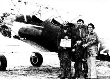
Faith Krysta-Johnson recalled, “Our father (Norman Krysta) earned his pilot license from a woman at Monroe & kept his Taylorcraft BC12-D at that airport.
He bought the airplane in 1946 when we were toddlers.
One of our biggest remembering comments was, 'Helen, we can't take that or Helen, we can't take that.'
Little did we know that dad was always concerned abut the weight of the plane.”
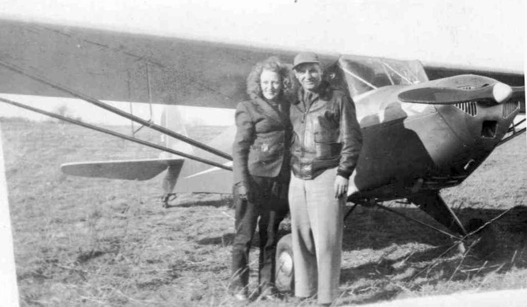
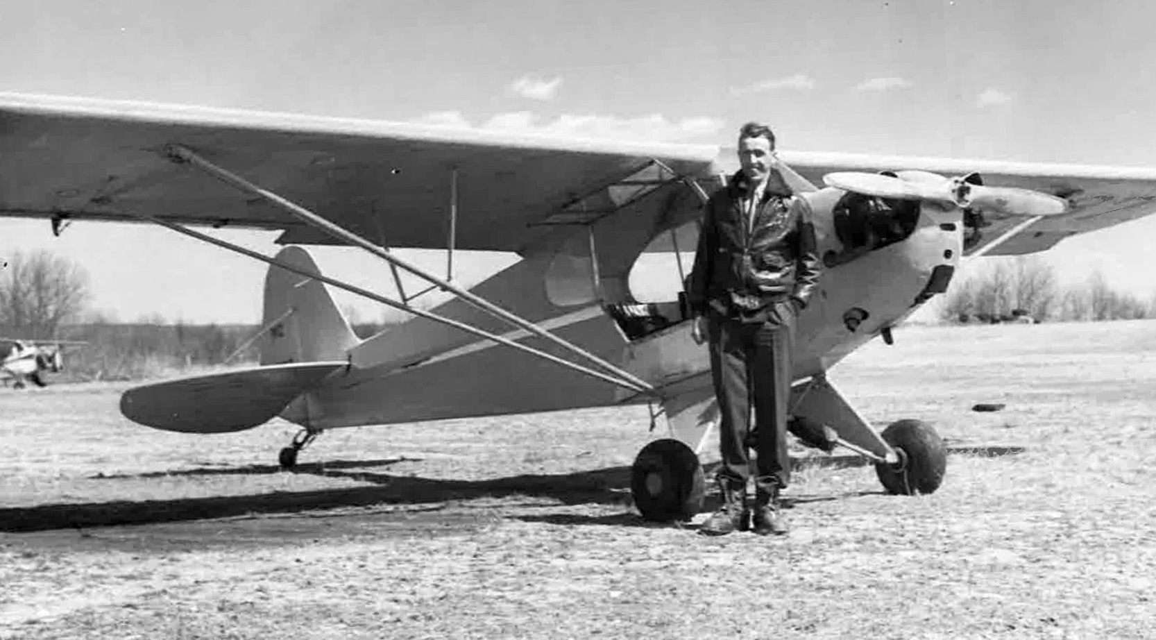
The earliest photo which has been located of Monroe Airport
was a circa 1946 photo (courtesy of Faith Johnson) of her father (Norman Krysta) & his sister (Catherine Krysta Edwards) in front of a Taylorcraft.
Kevin Daly reported, “After returning to civilian life, Ed Czap & a fellow experienced commercial pilot named Frank D’Elia leased the Monroe airfield from Ben Hurd.
While the family was setting up house in Huntington, Ed was up at the airfield each day working as the primary flight instructor.
According to Janet McMillan [Ed's daughter], he ran the Monroe Flying Service starting on 3/23/47.”
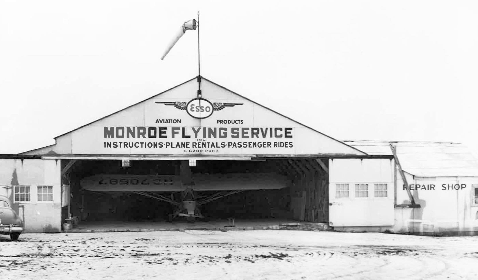
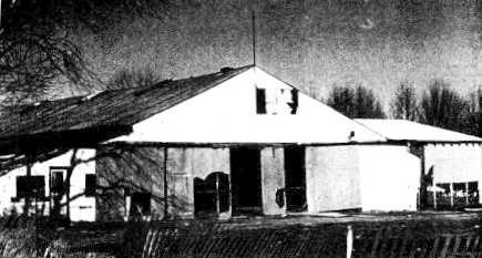
A circa 1947 photo of the Monroe Flying Service hangar (courtesy of Kevin Daly).
Kevin Daly reported, “The photo shows the Monroe Airport hangar during the time of Ed Czap’s proprietorship. Just inside rests NC 70587, a 1946 Piper J3C-65 Cub.
As a space-saving measure, the plane is tipped forward on its main landing gear, its propeller resting in cradle specially designed to keep the engine cowl just off the floor.
The weight of the engine, and possibly some remaining fuel in the gas tank, were enough to keep it safely in this tipped position.
This was common practice, even within the Piper Aircraft factory in Pennsylvania. To the left in the photo, we see a partial rear view of a Buick sedan.”
The earliest aerial view which has been located of Monroe Airport was a 4/12/49 USGS aerial view.
It depicted a single hangar which had been built on the northwest side of the property at some point between 1934-49,
near which was parked a single light plane.
Traces of the oval racetrack were still visible, in the area which had become the grass north/south runway.
According to a local resident, “The track [was] being used as both a runway & a taxiway. Clever.”
The 1950 NY Sectional Chart depicted Monroe Airport as having a 2,000' unpaved runway.

The 1953 USGS topo map depicted a north/south clearing with a few small buildings on the northwest side,
labeled simply as “Airport”.
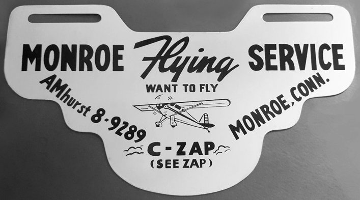
A circa 1950s license plate topper promoting the Monroe Flying Service (courtesy of Kevin Daly).
Kevin Daly reported, “The license plate topper was designed to hang below your car’s rear license plate. A little advertising in a sense but far more an indication of pride in your local airport.”
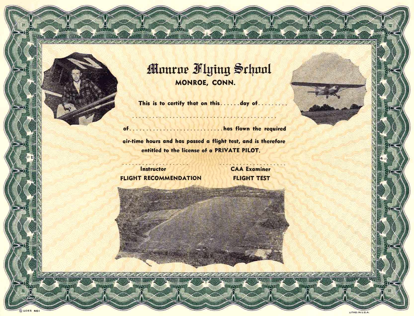
A circa 1950s certificate from the Monroe Flying School (courtesy of Kevin Daly).
Kevin Daly reported, “The coveted certificate that entitles a student to obtain a private pilot’s license. There’s only one way to get one of these. You must earn it!
And if you were one of the many who did during this era, you have Ed Czap to thank for your superb instruction. Thanks Ed!”
A circa 1950s photo of Monroe Flying Service owner Ed Czap & a Piper Cub (courtesy of Kevin Daly).
According to a local resident, “Ben's daughter Lois... once performed 26 consecutive loops in a Piper Cub over the airfield
with another young pilot who worked at the airport's gas line. She wasn't even 16 years old at the time.
Tragedy struck the Hurd family in the summer of 1955 when Ben's plane crashed into a mountainside in NY State on their way to Vermont.
One of Monroe's most forward-thinking men was no longer.
The family sold the airport & it continued with limited success under new ownership.”
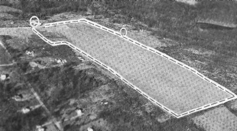
An undated aerial view looking northeast at Monroe Airport from the 1956 CT Airport Directory (courtesy of Stephen Mahaley).
The directory described Monroe as having a 2,000' sod north/south runway, and a hangar depicted at the north side.
The operator was listed as Monroe Flying Service, and the manager as Edward Czap.
Kevin Daly reported, “According to Janet McMillan [Ed Czap's daughter], he ran the Monroe Flying Service until 2/28/57.
She was just 11 years old when the family moved on to other aviation-related opportunities in the south.”
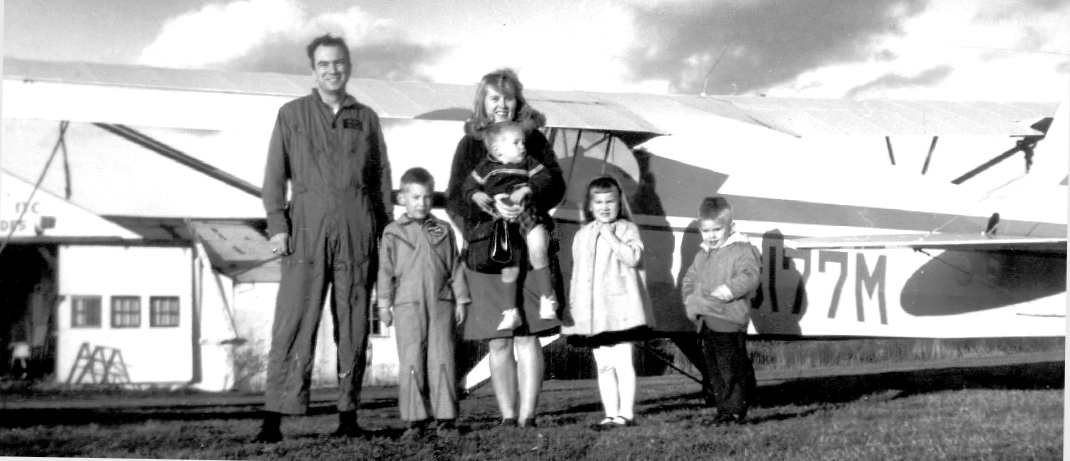
A circa 1962 photo (courtesy of Bill Feeny) of Bill's family in front of an Aeronca Champ at Monroe Airport.
Bill Feeny recalled, “My youngest brother probably going to get his 1st flight.
My father painted the Native American logo on the Aeronca Champ.
I mostly flew in a J3 Cub. I think myself & siblings all flew before we could walk.
In the pilot's room or whatever it was between the office & the hangar were some splendid & possibly valuable pictures on the wall done by Robert Osborn around WWII.
They are hilarious cartoons drawn with panache.
In the hangar was a coke machine with a heavy steel lever to deliver your coke in a glass bottle for 5 cents.
I remember seeing a trace of the race track from the air.”
A total of 3 light planes were visible near Monroe's hangar in a 1963 aerial photo.
Traces of the oval racetrack were still quite apparent.
The 1965 NY Sectional Chart depicted Monroe as having a 2,000' unpaved runway.
A 1965 aerial view of Monroe Airport (courtesy of Kevin Daly).
Kevin observed, “The taxiway has narrowed & is no longer using the back stretch of the former track.”
Lois Hurd Hayden recalled, “Later Connie Grasso & his brother Nick, leased the airport.
Morgan Keolian learned to fly at our airport. Thomas Walsh was our head instructor.”
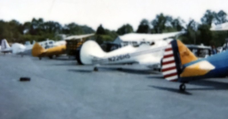
A circa 1960s photo (courtesy of Norm Roberts) of a row of biplanes at Monroe Airport.
Von Moody recalled, “Monroe Airport... run by Connie & Nick Grasso. Both acted as my instructors.”
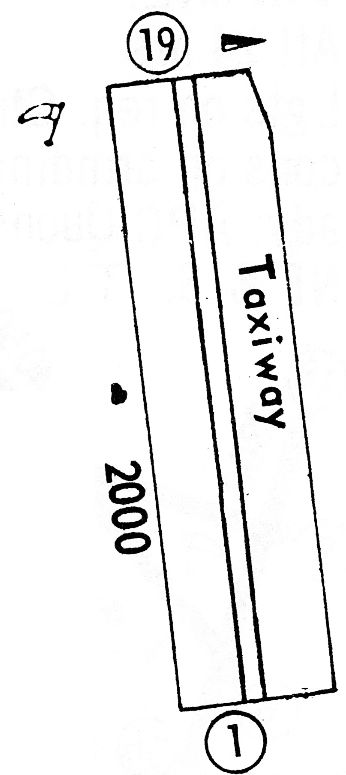
The 1968 Flight Guide (courtesy of Bob Levittan) depicted Monroe Airport as having a 2,000' unpaved Runway 1/19,
with 1 small building on the west side.
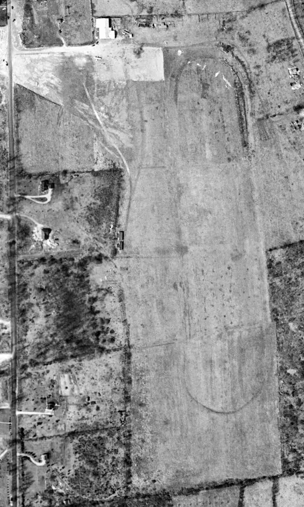
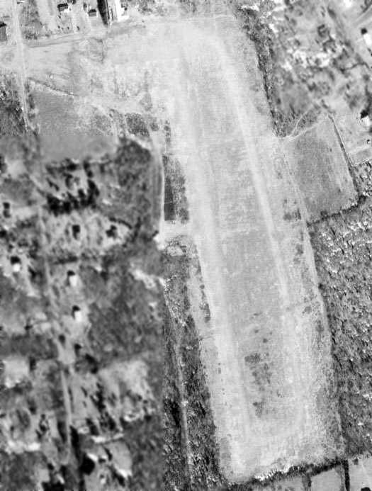
An 11/10/72 USGS aerial photo appeared to show Monroe Airport at its zenith of popularity,
with a total of 10 light planes visible on the field.
According to a local resident, “Look closely & you can see the circle at the center of the field, no doubt a skydiving target.”
Sean Fowler recalled, “As a child, I lived off of Cross Hill Road & would watch skydivers drop in there.
I think they used T-10 rounds or some early equivalent.
Seeing that airfield as a child inspired me to eventually become a skydiver & an ultralight pilot, over the years.”
An undated photo of the Monroe Airport hangar (courtesy of Dave Jaundrill).
The only photo which is available showing an aircraft at Monroe Airport
was a 1970s photo of Chuck & Judy Neuchterlain in front of their Stearman at Monroe (courtesy of Dave Jaundrill).
The last depiction which has been located showing Monroe Airport was on the 1973 USGS topo map.
It depicted Monroe as having a north/south unpaved runway, with a single small hangar on the northwest side.
The last aeronautical chart depiction which has been located of Monroe Airport was on the June 1973 NY Sectional Chart (courtesy of Ron Plante),
which depicted Monroe as having a 2,000' unpaved runway.
According to a local resident, Monroe Airport “was unofficially closed by 1973.
The land was eventually sold. Eventually the airport was abandoned, the field grew over.”
Monroe Airport was evidently closed at some point between 1973-79,
as it was no longer depicted on the December 1979 NY Sectional Chart (courtesy of Ron Plante).
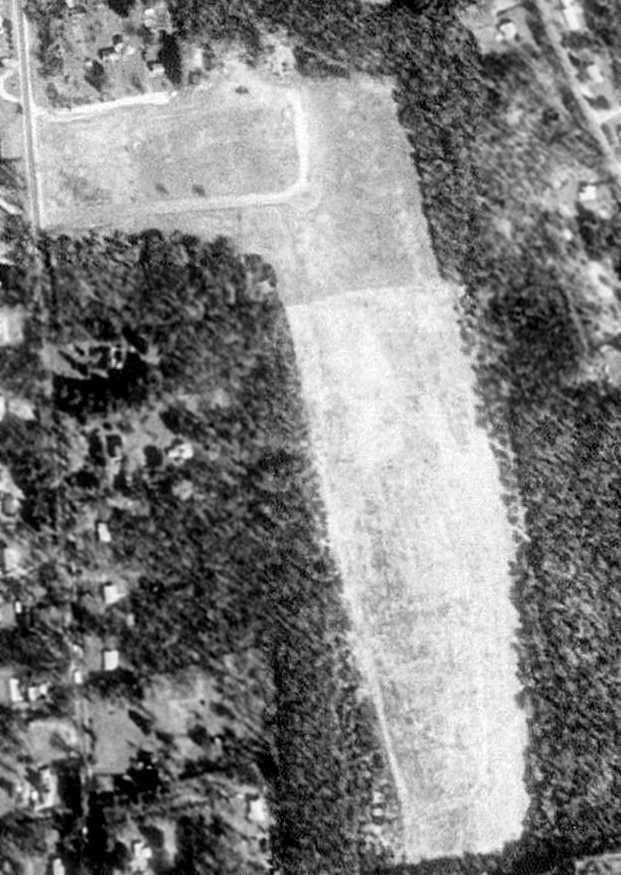
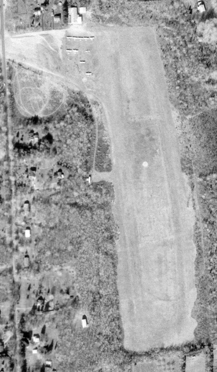
The 4/12/91 USGS aerial view depicted Monroe Airport as remaining mostly clear,
but the northwest side had evidently been started to be reused as a cemetery, and the hangar had evidently been removed.
Sean Fowler recalled, “I actually managed to fly out of the Monroe Field a few times in a powered parachute (paraplane) back in 2004.
A stern talking-to from a local officer trying to hold back laughter brought that to an end, however.
Still... it was a life dream completed.”
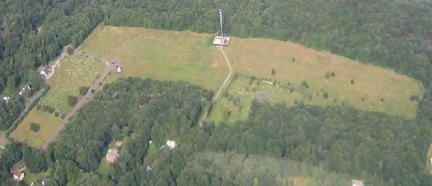
A 2006 aerial view by Dave looking northeast depicted 2 cemeteries & a cell phone tower occupying the site of Monroe Airport.
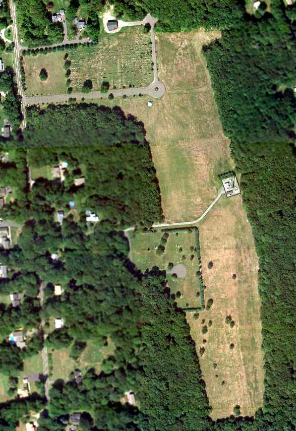
An 8/31/10 aerial view depicted 2 cemeteries & a cell phone tower occupying the site of Monroe Airport.
Kevin Daly observed, “If you know where to look you can still see the stonewalls just beneath the soil
exactly where Ben & young Lois buried them at night nearly 70 years ago.”
According to a local resident, “The land is now primarily Saint John's Cemetery. It also contains a small Jewish Cemetery & a cell phone tower.
The field's windsock... I discovered the original remains of the windsock in the woods a few years back.
It's fallen but it's still in the exact location it was originally built when the airport was opened in 1940. It looks homemade.”
Faith Krysta-Johnson reported in 2014, “A few years ago, I did find the little airport, parked my car & went out into the fields.
The gentlemen who was cutting the grass stopped his machine & wanted to know if I was OK as he saw tears coming down my face.
I told him that I felt like I was at home & remembered dad tipping his wings by the house,
which meant that he was landing the plane at Monroe Airport & will be home for dinner.”
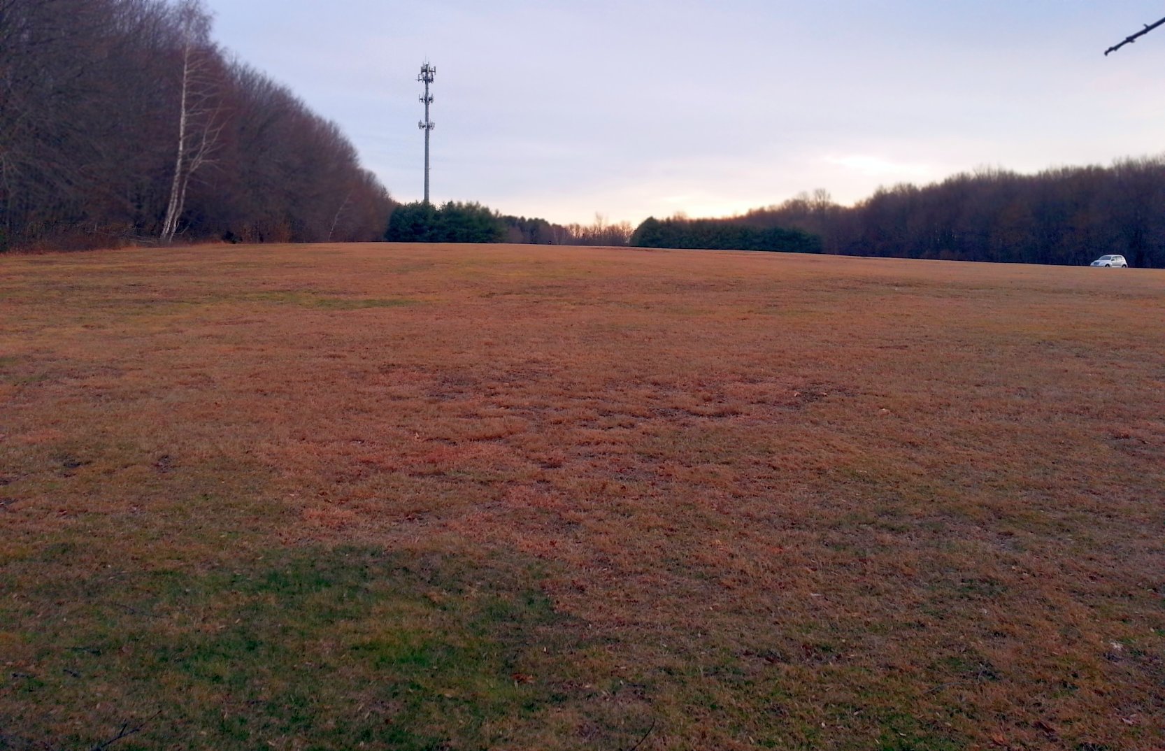
A 2/8/17 photo by John Paul looking south along the former Monroe Airport runway.
John reported, “What surprised me was the number of people there just because of the weather.
I met an old man golfing near the skydiving target who remembered when it was an airfield.”
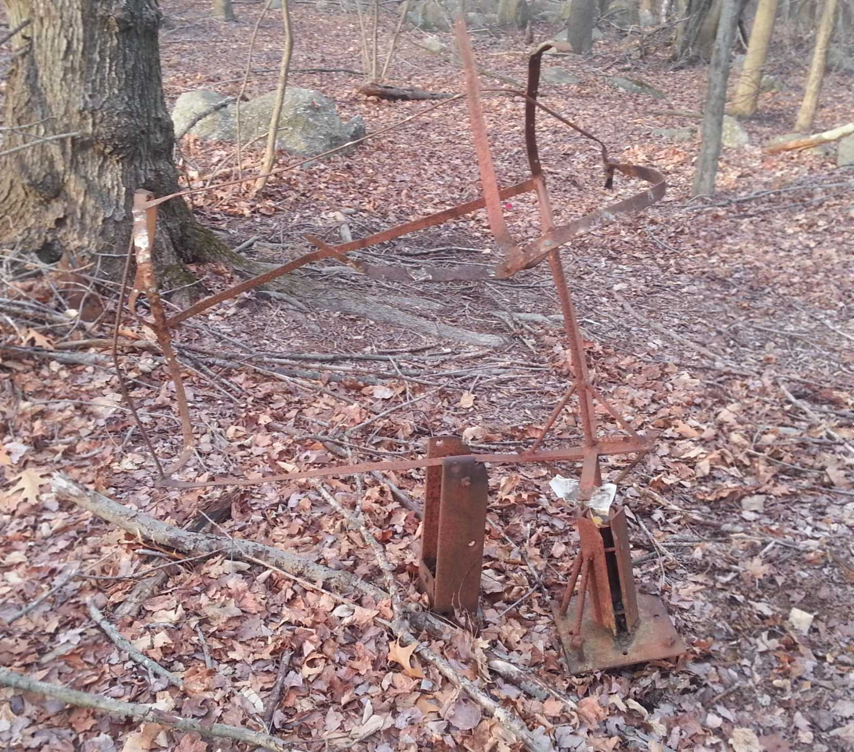
A 2/8/17 photo by John Paul of the remains of the Monroe Airport windsock pole.
John reported, “Just behind the mounting point for the sock, is what I assume was the base for the pole that held it up.”
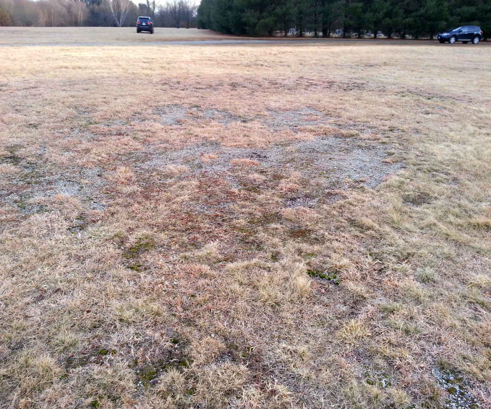
A 2/8/17 photo by John Paul of the remains of the Monroe Airport skydiving target.
John reported, “It's not in good shape, having been made of gravel, but it's still identifiable.”
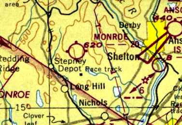
The site of Monroe Airport is located northwest of the intersection of Monroe Road & Cross Hill Road.
____________________________________________________
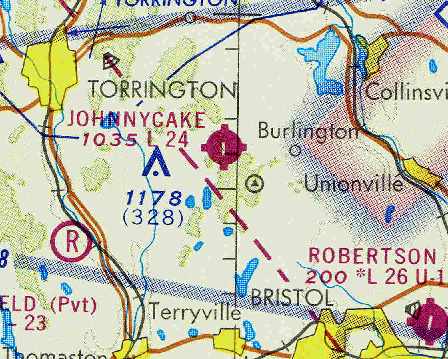
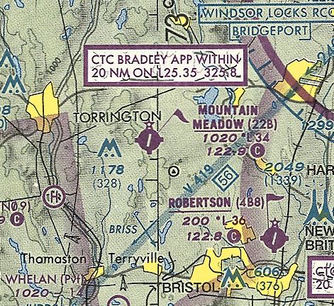
Jonnycake Airport / Mountain Meadow Airport (22B), Burlington, CT
41.77, -73.01 (West of Hartford, CT)
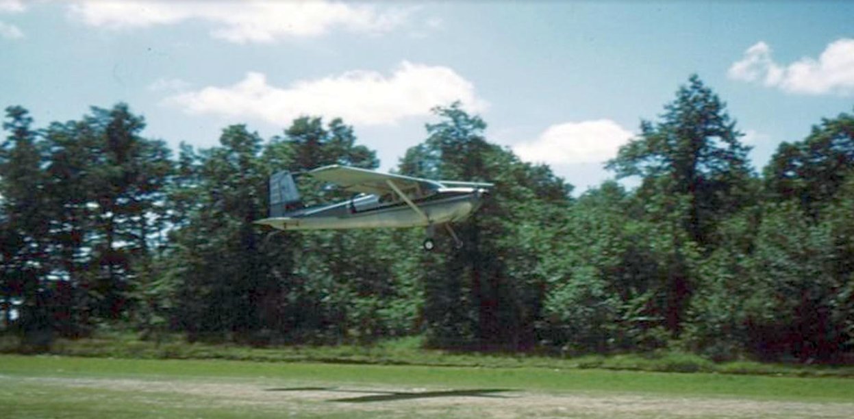
A 1960 photo by Bill Schultz of a Cessna 180 taking off from Johnnycake Airport.
This small general aviation airport may have been established at some point between 1958-60,
as it was not yet depicted at all on a 1955 aerial photo, nor on the 1958 NY Sectional Chart.
The earliest reference to Johnnycake Airport which has been located
came from Steve Walcott, who recalled, “We moved to Harwinton (2 miles southwest of JohnnyCake) in the late spring of 1960.
The airport was a well established airfield at that time, although the runway was turf. Fred Pesce was Manager.
The flight shack, pumps, parking lot, and school hangar (and what would become the taxiway)
were located on the Litchfield County / Harwinton side of the line.
The general hangars, tie-downs, sock, and runway were on the Hartford County/Burlington side of the line.”
The earliest depiction which has been located of Johnnycake Airport was a 1960 photo by Bill Schultz of a Cessna 180 taking off.
The earliest aeronautical chart depiction which has been located of Johnnycake Airport was on the January 1961 NY Sectional Chart.
It depicted Johnnycake as having a 2,400' unpaved runway.
Jonnycake Airport was not yet depicted on the 1962 USGS topo map.
John Clark recalled, “Johnnycake.. I was an instructor there for about 3 months in the early 1960s.
When I was at Johnnycake I worked for Fred & the runway was probably one of the worst around.
It was turf but that is a nice word in relation to the actual condition of the runway.
Rock & rough would be a better description of its condition.
I had a tailwheel vibrate right off of a Cessna 170 on one landing there.
I remember several mornings when we would have to go out on the runway & move the neighbor's cows off the field.”
Steve Walcott recalled, “I began flight training at Johnnycake in 1965. It then had a 2,800’ newly-paved runway (but no markings).
By late 1967 the south 400’ had deteriorated & the length was redesignated back to the original 2,400’.
Still no taxiway, still no markings.
The 3’ high boundary fence posts / truncated telephone poles & steel cable were still at 2,810’ from the Runway 19 threshold
(I dinged the empenage on those in a Cessna 150 while on final approach due to wind shear that closed the airport after I landed).
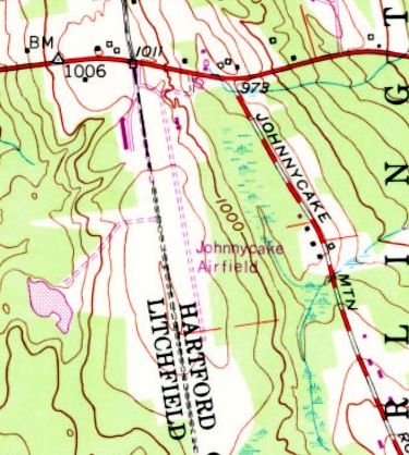
The 1969 USGS topo map depicted “Johnnycake Airfield” as having a single unpaved northwest/southeast runway, with a small building at the north end.
The January 1971 NY Sectional Chart (courtesy of Chris Kennedy)
depicted Johnnycake as having a single 2,400' paved runway.
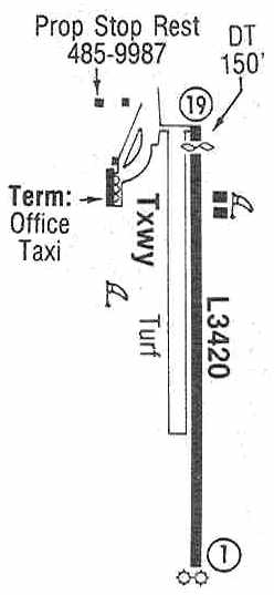
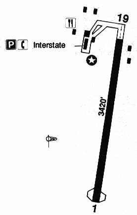
The 1987 Flight Guide (courtesy of Chris Kennedy)
depicted Johnnycake as having a single 3,420' paved Runway 1/19, with a parallel turf taxiway on the west side.
Two hangars were depicted on the east side of the runway,
along with the Prop Stop Restaurant on the southwest side, and the terminal & office on the west side of the field.
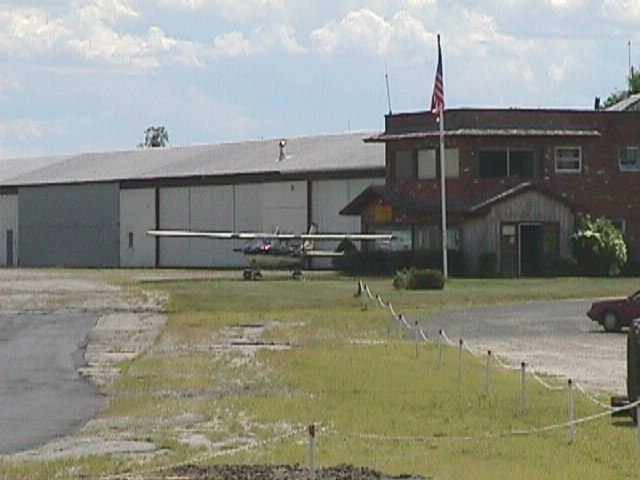
A circa 1990s view of a Cessna 152 in front of Johnnycake's office building & hangars.
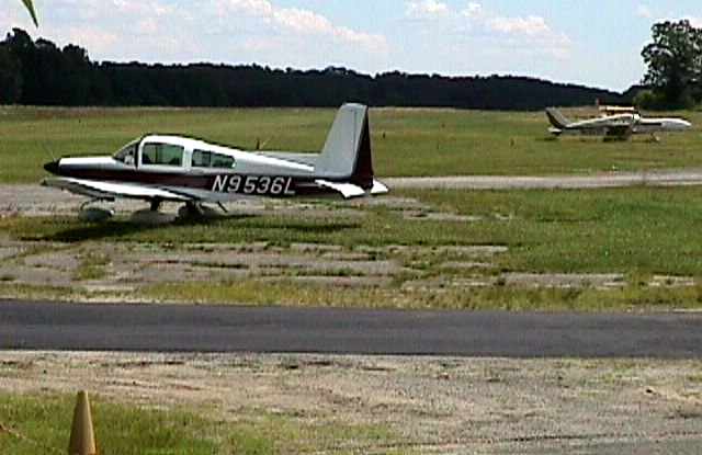
A circa 1990s view of a Grumman American Tiger & a Piper twin at Johnnycake.
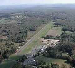
A circa 1990s aerial view looking southeast at Johnnycake Airport.
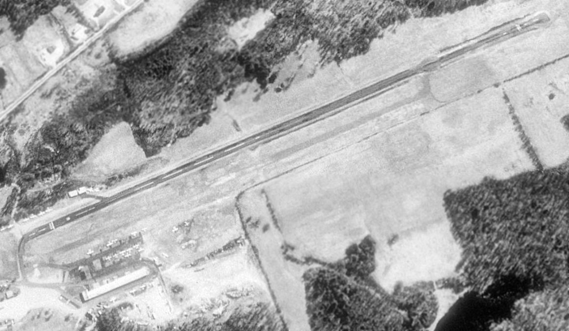
The last photo which has been located showing aircraft at Johnnycake Airport was a 4/1/91 USGS aerial view looking southeast,
which showed over a dozen light aircraft on the ramp on the northwest side.
The 1993 Jeppesen Airport Directory depicted Johnnycake as having a single 3,420' paved Runway 1/19.
Several buildings were depicted on the northwest & northeast side of the runway,
including the offices of Interstate Aviation.
At some point between 1993-2001, Jonnycake Airport was evidently renamed “Mountain Meadow” Airport,
as that is how it was depicted on the May 2001 NY Sectional Chart (courtesy of Ron Plante).
It was depicted as having a 3,400' paved runway.
In its last year of being listed in the FAA Airport/Facility Directory (2004),
Mountain Meadow Airport was described as having a single 3,420' asphalt Runway 1/19.
The field was said to be home to a total of 23 aircraft (21 single-engine & 2 multi-engine),
and it was said to conduct an average of 36 takeoffs or landings per day.
According to the Squadron One Flying Club, Mountain Meadow Airport was reported closed on 4/1/2004.
“Rumor has it that the two owners of the airport had an ongoing dispute about the property & this is the sad outcome.”
An article entited "A Big Debate Over A Tiny Airport" by Don Stacom appeared in the 5/10/04 issue of the Hartford Courant,
describing efforts to reopen the field.
It reported that Johnnycake Mountain Meadows Airport's flight school & fuel depot had closed years ago.
Vincent Scarano, manager of the FAA's New England Region airports division,
said “Airports like Johnnycake are important to aviation.
If you shut them down, those pilots & their planes go somewhere else that may already be congested.”
The FAA & the state Department of Transportation were reported to be holding out the lure of millions of dollars in aid
if the towns of Burlington & Harwinton were to buy Johnnycake &reopen it as a municipal airport.
But there's a problem: airport owner Richard Miller no longer wanted an airport on his property, and he was refusing to sell.
He ridiculed the defense that it could be an engine for regional business growth.
"It's been there 50 years, and what do you have?
The Landing Zone & the Countryside," he said, referring to two nearby restaurants that are popular with visiting pilots. "That's it."
Miller's position had municipal leaders talking about perhaps taking his land by eminent domain -
a prospect that unsettled even some of Johnnycake's supporters.
The FAA was interested in Johnnycake because of its location.
The agency's National Plan of Integrated Airports listed about 3,000 airports
that it considers significant to America's aviation system, and Johnnycake was on it.
The field is one of only 15 Connecticut airports on the list, and the only one near Litchfield County.
Buying Johnnycake, local pilots said, would be a sensible use of public money.
But acquiring Johnnycake would be expensive.
Burlington First Selectman Ted Scheidel estimated Miller's 237 acres were worth $4.7 million,
and pilots said that improving the facilities might run another $1 million.
The price could climb higher if Johnnycake's western edge, which was owned by Frederick Pesce, was added.
As much as 95 percent of the cost could be covered by the FAA,
with the CT DOT paying another 3.75 percent, said Richard Jaworski, a DOT transportation engineer.
The FAA, however, spends only $2-3 million a year on municipal airports in Connecticut,
and that's usually for improvements, not acquisitions.
Scarano acknowledged that the FAA hasn't subsidized the purchase of an airport in New England for as long as he can remember,
and that a potential $5-6 million price tag would be double the agency's yearly budget for municipal airport work in the state.
"We seldom buy an airport. But that doesn't necessarily mean anything," he said.
"It might be that the location would make it interesting to us."
Bill Thomas, president of the Simsbury Flying Club, said saving Johnnycake would benefit the state as a whole.
"As Bradley is growing, they'd prefer not to also have an influx of aircraft," he said.
"Aviation has an infrastructure - the fewer airports, the more planes will squeeze into the ones left."
Mountain Meadow was depicted as an abandoned airfield on the 2005 NY Sectional Chart.
A 2005 aerial photo depicted closed-runway Xs painted on the runway, and no aircraft on the field.
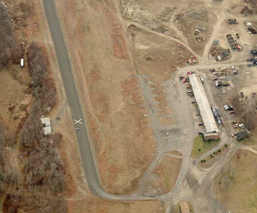
A circa 2006 aerial view looking south at Mountain Meadow Airport showed that the runway & hangar still remained intact,
but land had been cleared to the south of the hangar for some type of construction.
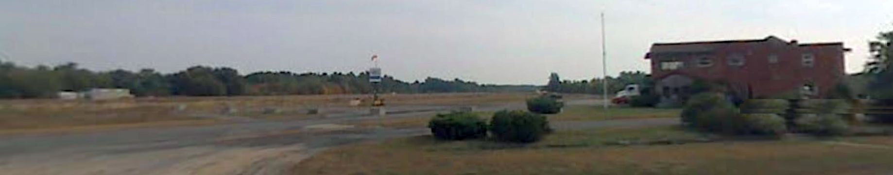
A 2007 photo looking south at Mountain Meadow Airport, showing hangars, the windsock, and the airport office.
Ian Maher reported of Jonnycake Aiport in 2013, “I drive by it nearly every day.
There are no planes; the last aircraft that I saw there was a helicopter being sold in front of Countryside last year.
For a while someone was landing their helicopter there, a very modern-looking one.
About 6 years ago, the area seemed to be used for cargo of some kind as well.
Helicopters could be seen daily carrying crates over the woods & back to the airport.
There has been a sense of mystery any time that the airport is actually used as it was once intended now.
Corn is grown in the summer months at the airfield, and the runway is difficult to see from the road.
Construction equipment is still there for building the condos, however I do not know if that project has made any actual progress.”
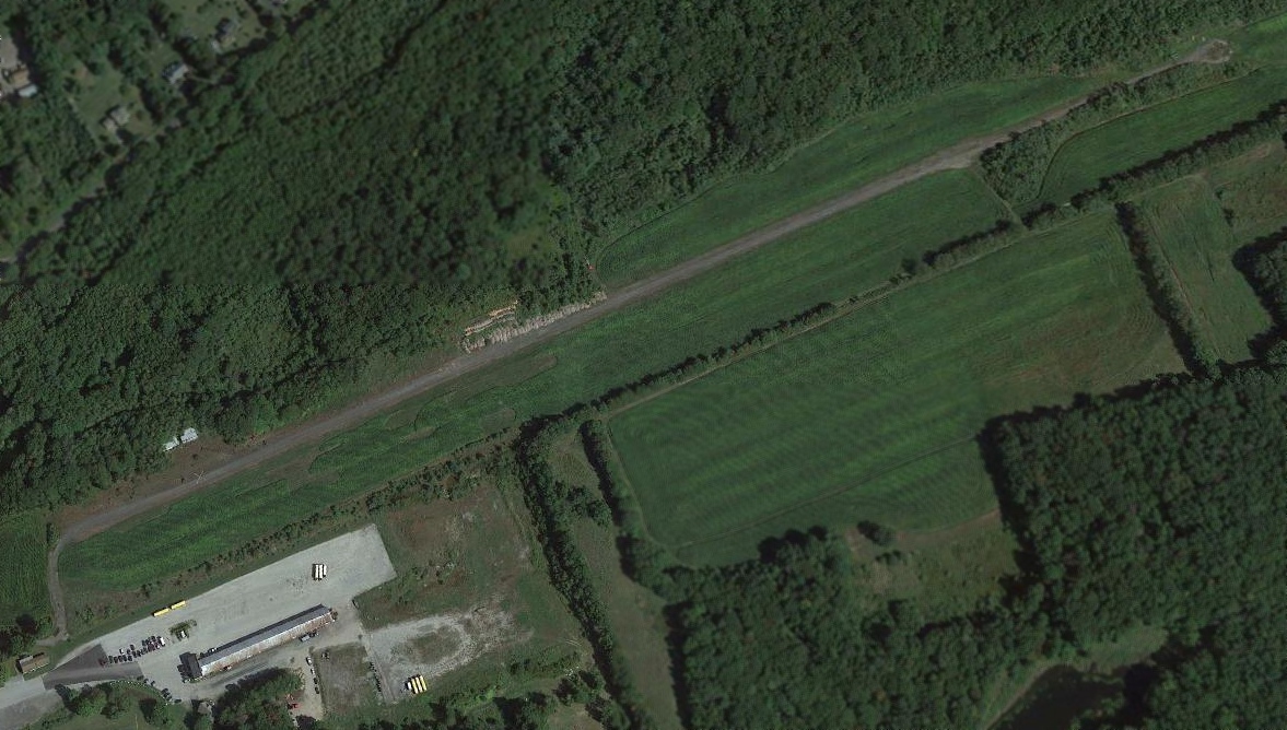
A 2019 aerial view looking southeast showed that the runway & buildings at Jonnycake Airport remained intact though deteriorated.
What a shame to see this nice little bit of general aviation infrastructure going to waste.
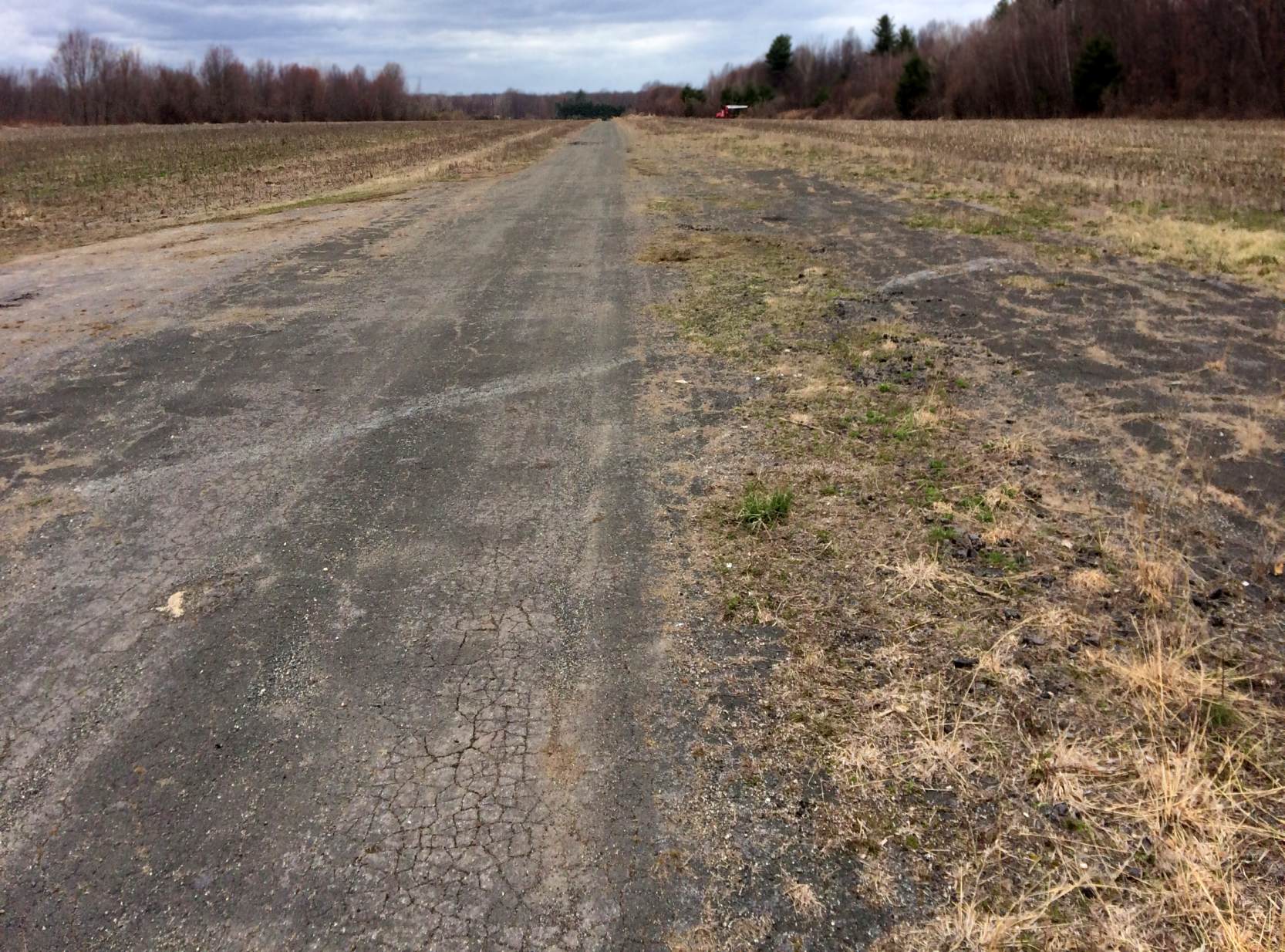
A 4/5/20 photo by Alex T.D. looking north along the remains of the Mountain Meadow Airport paved runway.
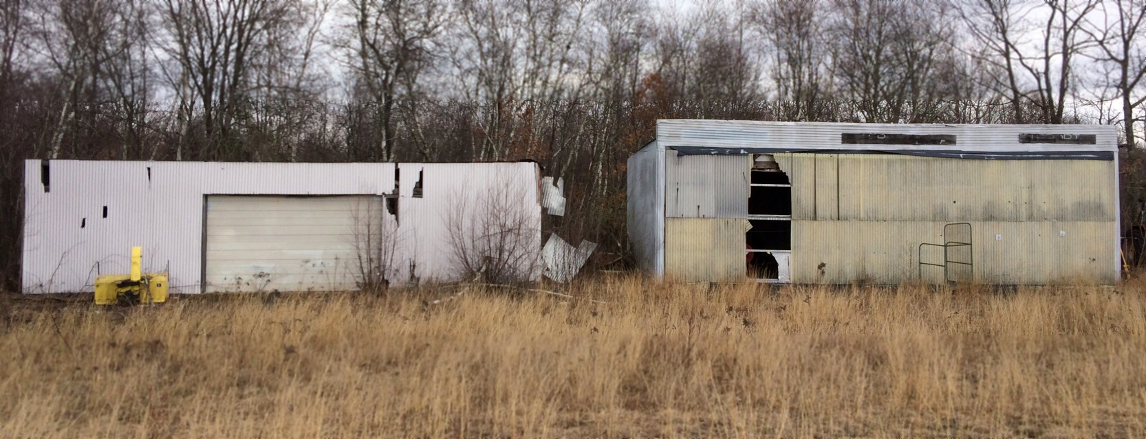
A 4/5/20 photo by Alex T.D. of 2 hangars which remain at the site of Mountain Meadow Airport.
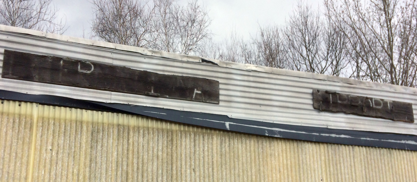
A 4/5/20 photo by Alex T.D. of the sign above the right hangar at the site of Mountain Meadow Airport, which appears to have said “Interstate Airport”,
presumably a reference to former airport business Interstate Aviation.
Johnnycake Airport is located southwest of the intersection of Route 4 & Johnnycake Mountain Road.
____________________________________________________
Since this site was first put on the web in 1999, its popularity has grown tremendously.
If the total quantity of material on this site is to continue to grow,
it will require ever-increasing funding to pay its expenses.
Therefore, I request financial contributions from site visitors,
to help defray the increasing costs of the site
and ensure that it continues to be available & to grow.
What would you pay for a good aviation magazine, or a good aviation book?
Please consider a donation of an equivalent amount, at the least.
This site is not supported by commercial advertising –
it is purely supported by donations.
If you enjoy the site, and would like to make a financial contribution,
you
may use a credit card via
![]() :
:
Please consider checking the box to make a monthly donatation.
For a mailing address to send a check, please contact me at: paulandterryfreeman@gmail.com
If you enjoy this web site, please support it with a financial contribution.
please contact me at: paulandterryfreeman@gmail.com
If you enjoy this web site, please support it with a financial contribution.
____________________________________________________
This site covers airfields in all 50 states.