
Abandoned & Little-Known Airfields:
Colorado: Southeastern Denver area
© 2002, © 2024 by Paul Freeman. Revised 9/28/24.
This site covers airfields in all 50 states: Click here for the site's main menu.
For a 7th year, the CO pages of this website are sponsored by the Colorado Pilots Association:
____________________________________________________
Please consider a financial contribution to support the continued growth & operation of this site.
C & S Airport / Cherry Creek Airport / Stouts Airfield (revised 9/27/24) - Denver-Douglas Airport (revised 9/28/24)
East Colfax Airport / Columbine Airport / Aurora Airpark (revised 9/27/24) - Englewood Airport (added 12/15/18) - Lowry Field (2nd location) / Lowry AFB (revised 4/24/20)
____________________________________________________
Englewood Airport, Englewood, CO
39.66, -104.91 (Southeast of Denver, CO)
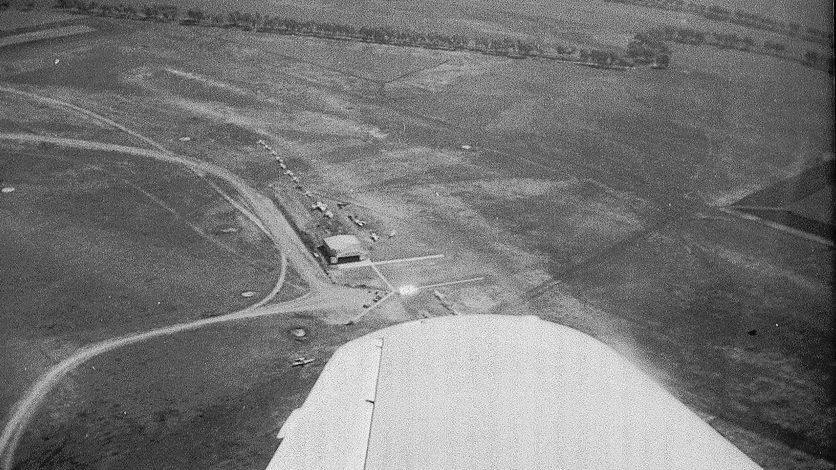
A 1941 aerial view by Stan Oliner (courtesy of Jim Urdea) looking northeast at Englewood Airport.
Jim Urdea reported, “The Englewood airport was located 6.5 miles southeast of the Colorado State Capitol Building & only 4 miles south/southwest of Lowry Field.
Englewood Airport appears to have come into existence before WW2, with the earliest located photo being a 1941 aerial view by Stan Oliner.
The busy field shows a large hangar, office building with adjacent parking lot, and at least a dozen small aircraft next to a north/south unpaved runway.”
Inexplicably, Englewood Airport was evidently not depicted on aeronautical charts for the first few years of its existence,
as it was not depicted on Denver Sectional Charts up through the August 1945 edition.
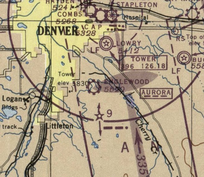
The earliest aeronautical chart depiction which has been located of Englewood Airport was on the March 1946 Denver Sectional Chart.
It depicted Englewood as a commercial/municipal airport.
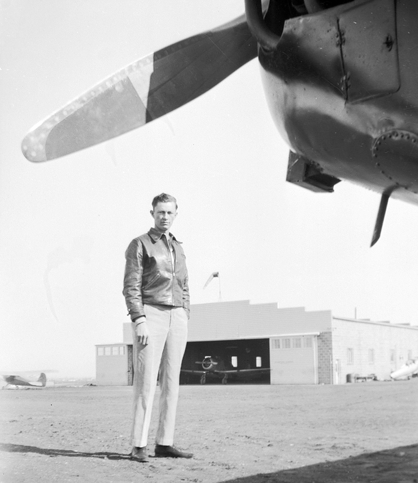
A 1946 photo (courtesy of the Englewood Public Library) showed an unidentified pilot, several aircraft, and the hangar at Englewood Airport.
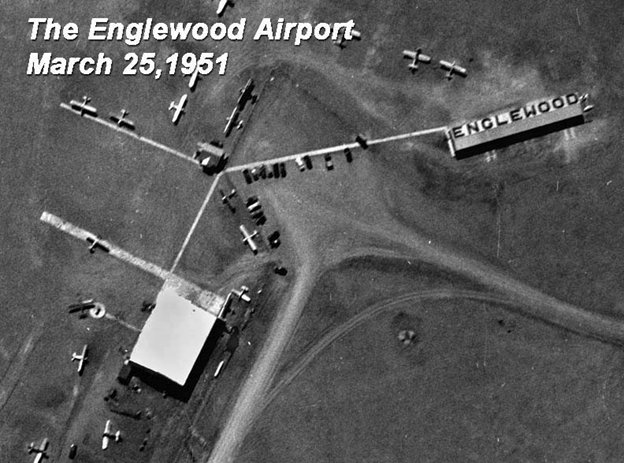
A 3/25/51 aerial view looking southeast at Englewood Airport (courtesy of John Young).
Jim Urdea noted, “It showed the addition of a covered aircraft parking structure, Englewood painted on the roof, southwest of the main hangar, with the airport’s office building between the two structures.
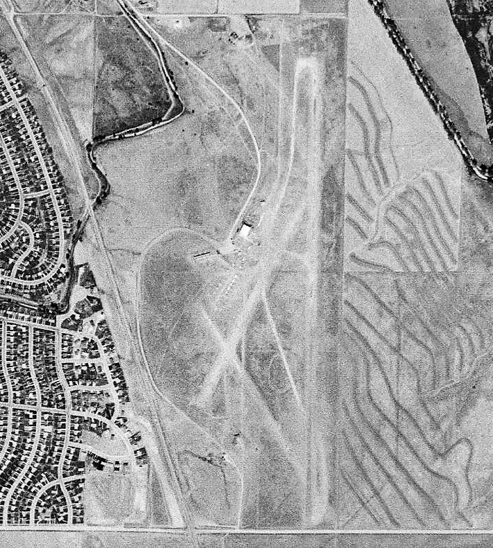
A September 1953 USGS aerial view of Englewood Airport (courtesy of John Young).
Jim Urdea noted, “It showed the overall layout of the field with a 4,500' main north/south runway with 2 shorter additional runways running northwest/southeast & northeast/southwest.”
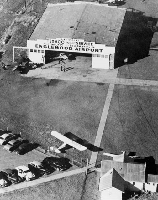
A 1954 aerial view looking northwest at the Englewood Airport hangar (courtesy of John Young).
Jim Urdea noted, “The number of cars combined with the sales & fuel signs displayed on the hanger testify that this was a busy general-purpose field.”
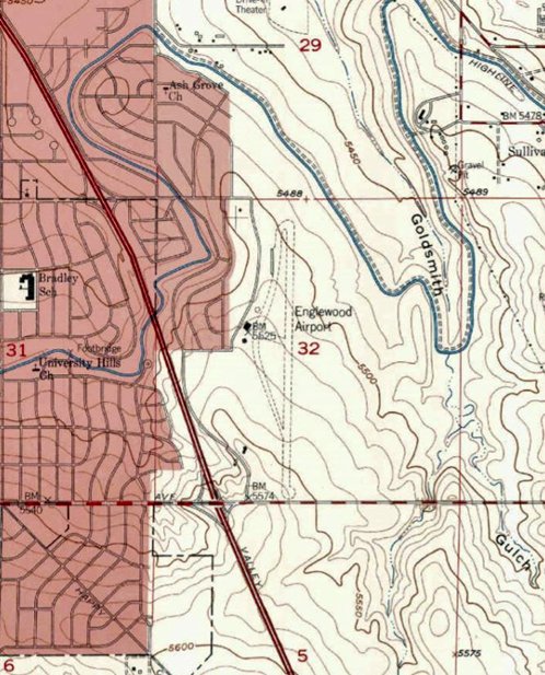
Englewood Airport, as depicted on the 1957 USGS topo map.
Jim Urdea noted, “USGS topographic maps make no mention of the airport until 1957 after it had been in operation for at least 16 years.
Only one runway is depicted & subdivision encroachment from the north & east can be seen.”
Jim Urdea reported, “Increasing property values with the University Hills subdivision expansion to the east
and upgrading of the Valley highway into I-25 through the 1950s signaled the beginning of the end for Englewood Airport.
The late 1950s saw the sale of the farmlands immediately east of the airport & residential housing construction began in earnest.”
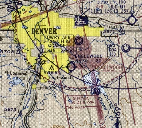
The last depiction which has been located of Englewood Airport was on the May 1959 Denver Sectional Chart.
It depicted Englewood Airport as having a 3,200' unpaved runway.
Jim Urdea reported, “The airport property itself was sold to developers in 1959.”
Englewood Airport was no longer depicted on the November 1959 Denver Sectional Chart.
According to Jim Urdea, the Englewood Airport property “was completely built over by the mid-1960s.”
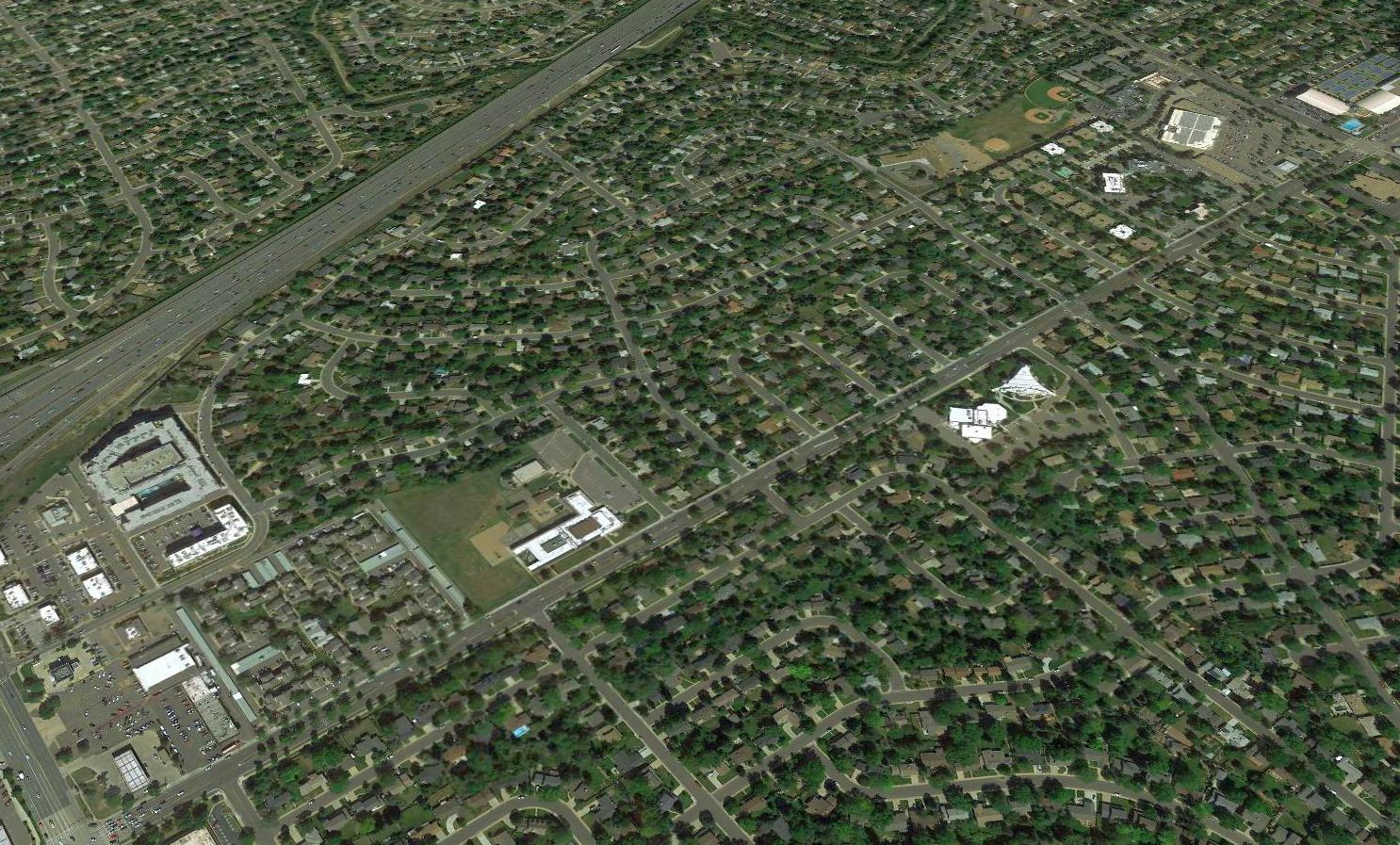
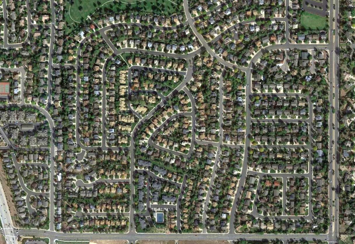
A 2018 aerial view looking northwest showed no trace remaining of Englewood Airport.
The site of Englewood Airport is located south of the intersection of Manaco Parkway & Yale Avenue.
____________________________________________________
C & S Airport / Cherry Creek Airport / Stouts Airfield, Aurora, CO
39.628, -104.813 (Southeast of Denver, CO)
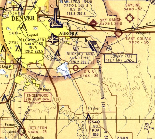
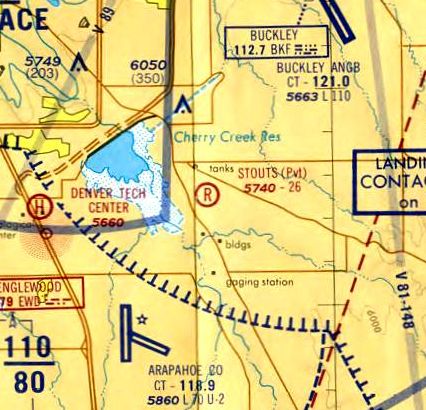
C & S Airport, as depicted on the June 1965 Denver Sectional Chart.
This small general aviation airport may have gone by a succession of names over its brief lifespan.
C & S Airport was evidently established at some point between 1964-65,
as it was not yet depicted on the 1963 Denver Sectional Chart or a 1964 aerial photo.
The earliest depiction which has been located of C & S Airport was on the June 1965 Denver Sectional Chart.
It depicted C & S Airport just east of Cherry Creek Reservoir, and having a 3,000' unpaved runway.
No airfield was depicted at this location on the 1966 USGS topo map.
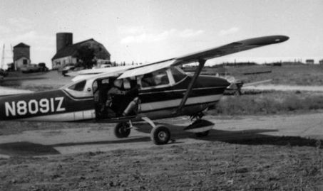
An August 1966 photo (courtesy of Ted Frison) of a Cessna 206 equipped for skydiving operations at Cherry Creek Airport.
Ted Frison recalled “I made my first jump there on 8/12/66, at what my log book shows as the 'Cherry Creek' Airport,
which I remember as being somewhere just east of the Cherry Creek Reservoir. It was fairly primitive.
We did our jump training in a barn & I have no recollection of an Fixed-Base Operator, although there may have been one.
The strip was owned by a farmer. We had to be careful about our operations, lest we interfere with Buckley ANGB.
I'd say we flew out of Stouts, and called it the 'Cherry Creek Jump Area'.”
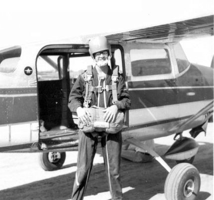
An August 1966 photo of Ted Frison ready to jump (“at age 16 - before my driver’s license”) front of a Cessna 206 equipped for skydiving operations at Cherry Creek Airport.
Ted Frison recalled, “I landed - alive to the relief of my dad, who had to drive me there because I didn’t yet have a driver’s license!
I made my last jump there in July 1967.”
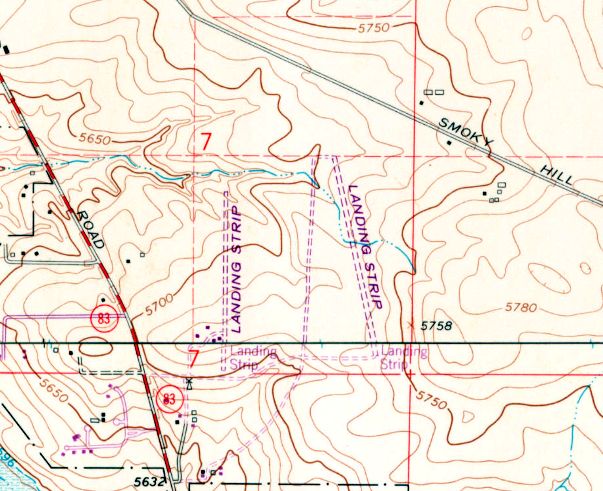
The 1971 USGS topo map depicted 2 unpaved north/south runways separated by only a quarter-mile, both labeled simply as “Landing Strip”.
Were these part of the same airfield, or two unrelated airfields in close proximity?
A 1971 aerial photo also depicted C & S Airport as having 2 unpaved north/south runways separated by only a quarter-mile.
C & S Airport was still depicted on the 1971 Denver Sectional Chart.
C & S Airport was evidently renamed Stouts Airfield at some point between 1971-74,
as the 8/15/74 Denver Terminal Chart (courtesy of Ted Frison) depicted Stouts as a private airfield having a 2,600' unpaved runway.
Ted Frison observed, “There is on the chart a private airport called Stouts just south east of the reservoir, along the road to Parker & it's possible that's where we jumped.
It's location is closer to what I remember.”
According to Walter Jazun, Roger Stout owned Stouts Airfield.
Stouts Airfield was evidently closed (for reasons unknown) at some point between 1974-77,
as it was no longer depicted on the February 1977 Denver Sectional Chart.
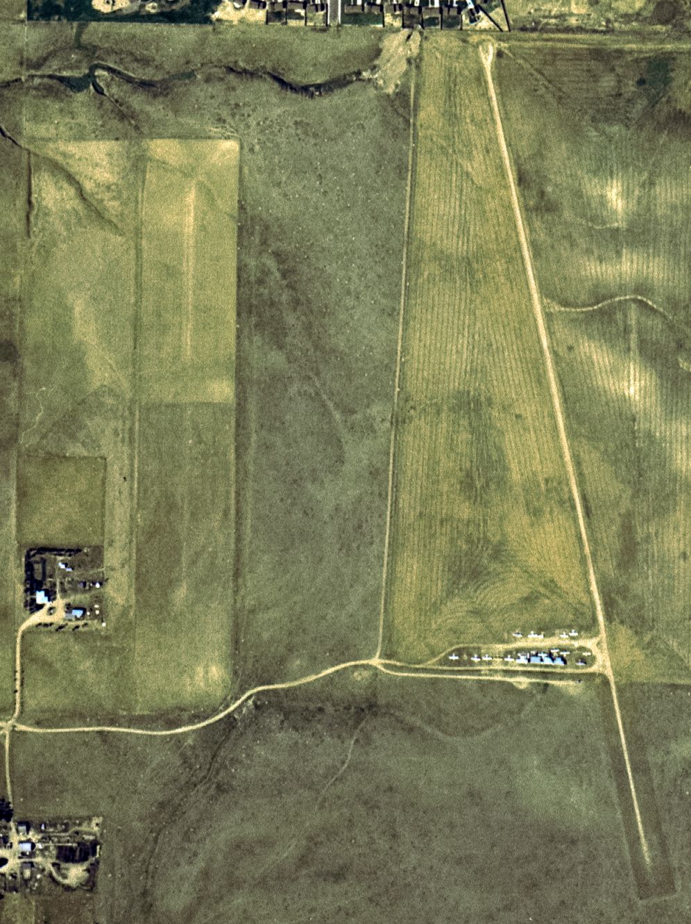
A 7/5/78 USGS aerial view showed the western runway remained intact, with a few small buildings at the southwest side, but devoid of aircraft.
But the eastern runway had a dozen light single-engine aircraft parked on its southwest side.
The 1980 USGS topo map still depicted the eastern runway, but the western runway was no longer depicted.
A 1984 aerial view showed that both runways had been replaced by construction for new housing.
A 2015 aerial view showed no trace remaining of Stouts Airfield.
The site of Stouts Airfield is located northeast of the intersection of East Bellevue Road & South Parker Road.
39.628, -104.813
Thanks to Ted Frison for pointing out this airfield.
____________________________________________________
Denver-Douglas Airport, Castle Rock, CO
39.417, -104.881 (Southeast of Denver, CO)
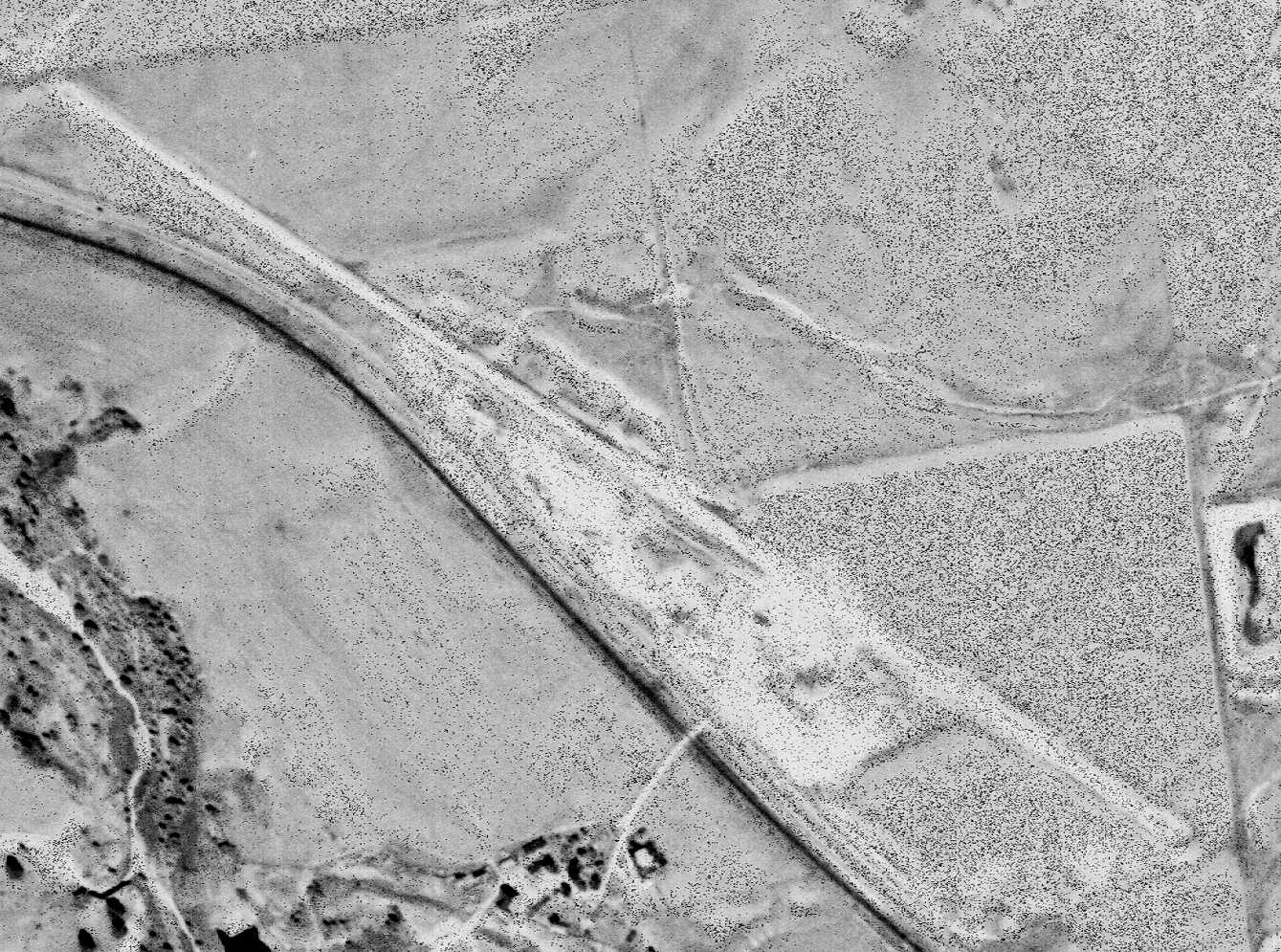
Denver-Douglas Airport, as depicted on a 10/4/64 USGS aerial view.
Denver-Douglas Airport was not yet depicted on a 1955 aerial photo.
An article entitled “Denver-Douglas Airport Well Along” appeared in the 4/25/63 Douglas County News:
“Usually an earth-moving activity indicates another subdivision starting in popular Douglas County
but when folk observed Arnold Construction equipment working just off Highway 85, north of Castle Rock, it didn't seem to give the appearance of house-building.
Upon being asked , Floyd Arnold said that he & Robert Wenger were building a 4,000' runway airport, named the Denver-Douglas Airport.
The landing strip will angle about 120 degrees southeast & about 300 degrees north/northwest.
The airport landing strip will accommodate any aircraft up to & including the well-known DC-3.
By May 10th, Floyd says, the airport should be in full operation.
Eighty - One Hundred octane gas will be available for most fuel injection motors requiring 90-100.
Frank Niehus recalled “The very short-lived Denver-Douglas air strip...
I remember a friend who was to be in my wedding had to cancel because he was working on building that strip, that was 6/1963.
There was never any buildings at that location & I think I might have landed or made a few touch & go's there.”
Denver-Douglas Airport was not yet depicted on the June 1963 Denver Sectional Chart.
Rick Calhoun recalled, “I flew out of Denver-Douglas between April 1963 - August 1967.
It was a single dirt strip & was constructed & owned by retired USAF Colonel Robert Wenger who used it to run a flight training operation.
I know it was on a Denver Sectional because I remember conversations about how hard it was to get the FAA to recognize it.
The only thing in the area during the time the airport was in operation was the construction company located on US 85 located across the street.”
The earliest depiction which has been located of Denver-Douglas Airport was a 10/4/64 USGS aerial view.
It depicted a single northwest/southeast unpaved runway.
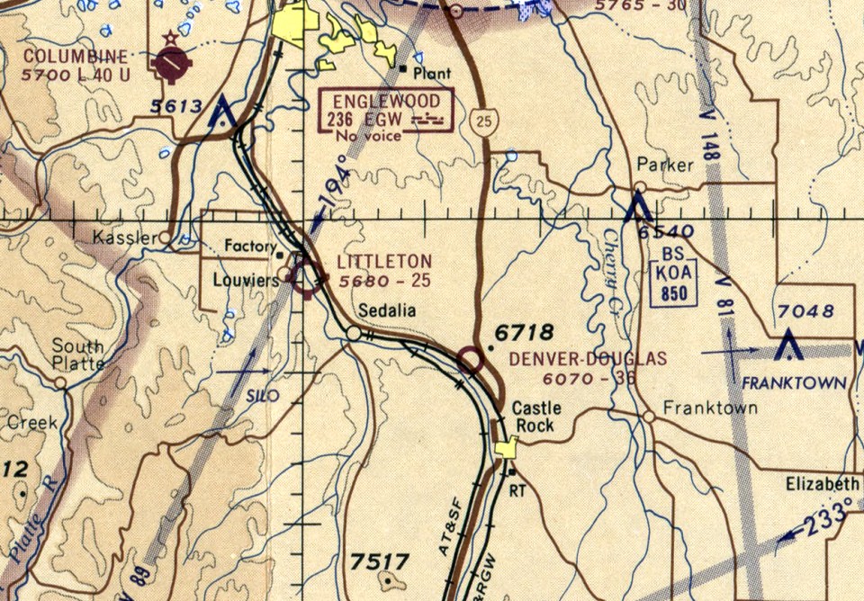
The earliest aeronautical chart depiction which has been located of Denver-Douglas Airport was on the June 1965 Denver Sectional Chart.
It depicted Denver-Douglas Airport as having a 3,600' unpaved runway.
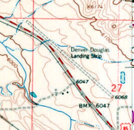
The 1965 USGS topo map depicted “Denver Douglas Landing Strip” as having an unpaved northwest/southeast runway.
There were no buildings depicted on the airfield.
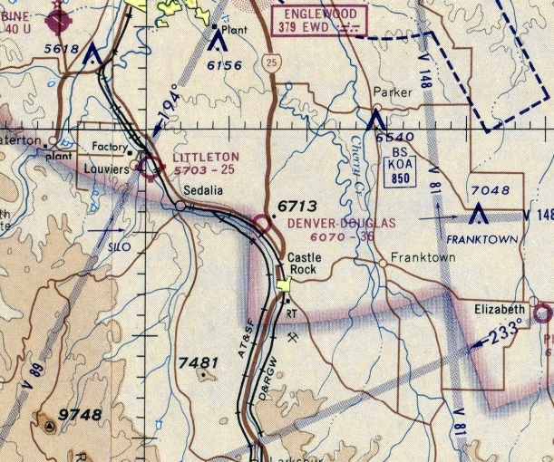
The last aeronautical chart depiction which has been located of Denver-Douglas Airport was on the December 1967 Denver Sectional Chart.
It depicted Denver-Douglas Airport as having a 3,600' unpaved runway.
Denver-Douglas Airport apparently lasted less than 5 years, as it was no longer depicted at all on the June 1968 Denver Sectional Chart.
A 1071 aerial view depicted the remains of Denver-Douglas Airport's runway.
The 1980 USGS topo map still depicted Denver-Douglas labeled as “Landing Strip”, but that most likely indicates it was no longer in operation by that point.
Denver-Douglas Airport was no longer depicted at all on the 1994 USGS topo map.
A 1999 aerial view showed construction for houses had started to cover the Denver-Douglas Airport site at some point between 1993-99.
A 2015 aerial view showed no trace remaining of Denver Douglas Airport.
The site of Denver Douglas Airport is located east of the intersection of Route 85 & Castlegate Drive North.
Thanks to Frank Niehus for pointing out this airfield.
____________________________________________________
East Colfax Airport / Columbine Airport / Aurora Airpark (01V), Aurora, CO
39.73, -104.65 (East of Denver, CO)
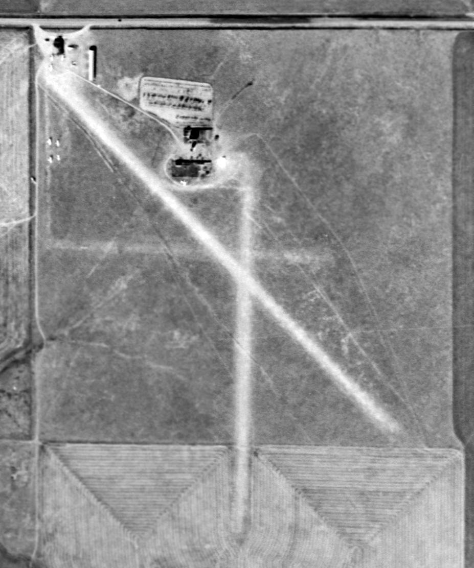
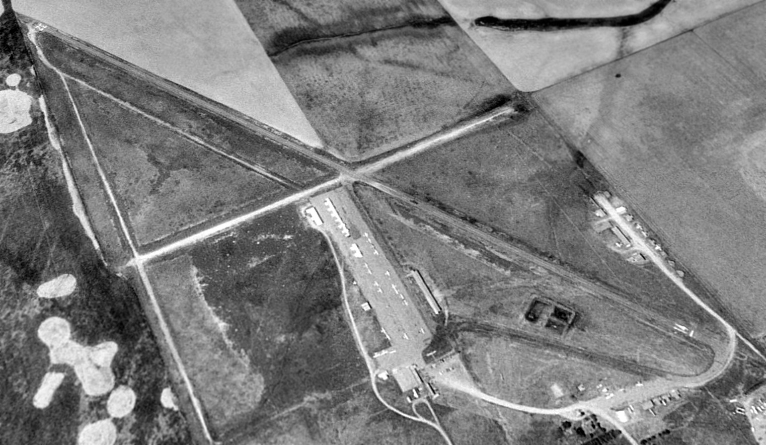
A 10/21/48 USGS aerial photo of East Colfax Airport.
This general aviation airport was apparently built at some point between 1945-48,
as it was not yet depicted on the February 1945 Denver Sectional Chart (courtesy of Richard Doehring).
The earliest depiction which has been located of East Colfax Airport was on a 10/21/48 USGS aerial photo.
It depicted East Colfax" Airport as having 3 unpaved runways, with a half-dozen light aircraft & a few small buildings on the northwest side.
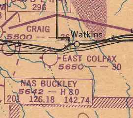
The earliest aeronautical chart depiction which has been located of East Colfax Airport
was on the February 1949 Denver Sectional Chart (courtesy of Chris Kennedy).
It depicted East Colfax as having a 3,000' unpaved runway.
East Colfax's runway was lengthened at some point between 1949-63,
as the October 1963 Sangre De Christo Mountains World Aeronautical Chart(courtesy of Donald Felton)
depicted the field as having a 5,000' unpaved runway.
East Colfax Airport was depicted in the 1967 Flight Guide(courtesy of Chris Kennedy)
as having 2 unpaved runways: 5,000' Runway 13/31 & 2,550' Runway 7/25.
Several taxiways led to a cluster of hangars on the north side of the field,
and there was also another line of small hangars on the west side of the field.
The field was said to conduct skydiving operations.
Tom Richards recalled of East Colfax Airport, "I learned to fly there in the late 1960s
and kept my Cessna 120 tied down there until I sold it in 1970.
It was a great place in those days. Denver was about half the size it is now.
Flying out of East Colfax was basically unrestricted.
The only real problem we had was of course Stapleton and sometimes Buckley ANG Base."
"East Colfax" Airport was depicted on the 1970 Denver Sectional Chart(courtesy of Vince Granato)
as having a 5,000' unpaved runway.
The 1974 Denver Terminal Chart depicted East Colfax Airport as having a 5,000' unpaved runway.
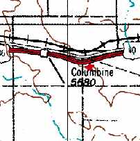
At some point between 1974-76, the field was apparently renamed Columbine Airport,
that is how it was labeled on the 1976 USGS topo map.
That must have caused confusion, as there was also another Columbine Airport in nearby Littleton.
It was depicted as having a single runway, oriented northwest/southeast.
According to John DeBrouwer, “Vaughn Cole of Cole Aviation carried the airport name from Littleton to Aurora.”
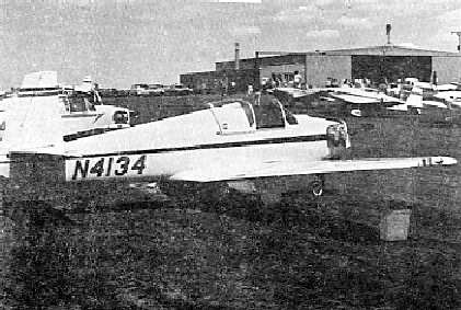
A 1976 photo by Larry Dale of a Mooney M-18L Mite at Columbine Airport.
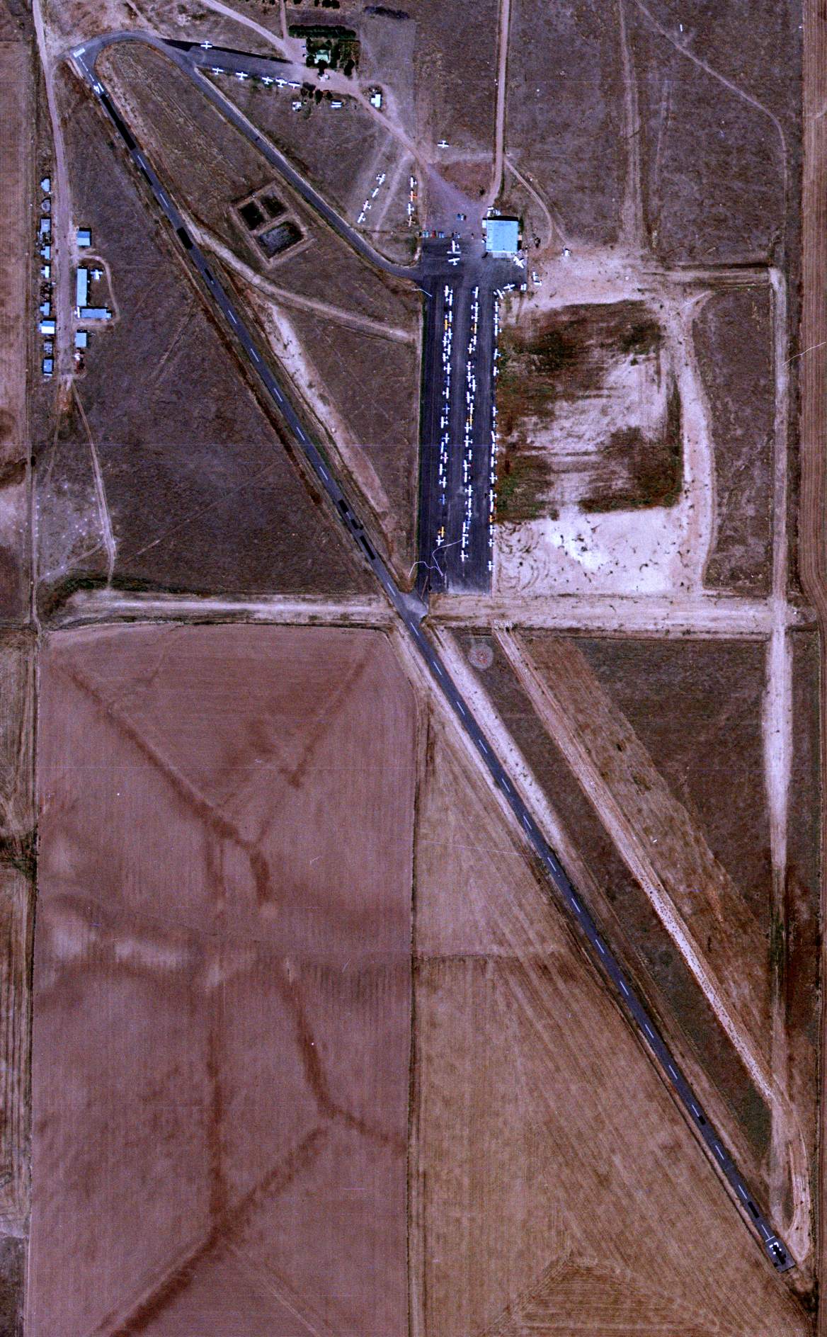
A 9/21/80 USGS aerial view depicted Columbine Airport at perhaps its peak of popularity, with dozens of light aircraft.
The 1982 AOPA Airports USA directory (courtesy of Ed Drury) described Columbine Airport in Aurora as having a 5,000' asphalt Runway 14/32 & a 2,550' dirt Runway 7/25.
The field was said to offer fuel, major repairs, tiedowns, hangars, charter, flight instruction, and plane rental.
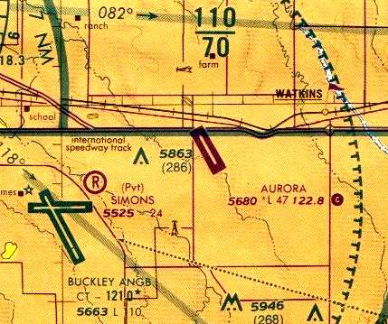
At some point between 1982-85 the field was renamed again, this time to Aurora Airpark,
as the August 1985 Denver Terminal Chart (courtesy of Stu Sibitzky) depicted Aurora as having a single 4,700' northwest/southeast paved runway.
The June 1989 Denver Terminal Chart (courtesy of Robert Brown) depicted Aurora as having a single 4,700' paved runway.
The 1992 Flight Guide (courtesy of Chris Kennedy) depicted Aurora as having a 4,687' paved runway 14/32
and a 2,300' dirt Runway 8/26 (which was closed to transient aircraft).
A large number of small hangars were depicted on the northwest & northeast sides of the field.
The field was said to conduct operations by ultralight aircraft & cropdusters.
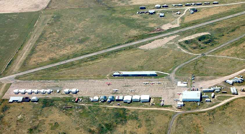
A 1993 USGS aerial view looking southwest showed Aurora Airpark had 2 ramp areas northwest & northeast of the runway intersection with a large number of individual T-hangars,
as well as a substantial number of aircraft visible parked outside.
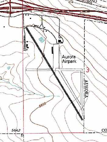
By 1998, the USGS topo map showed that the airport had been renamed Aurora Airpark.
The August 1999 Denver Terminal Aeronautical Chart (courtesy of Ron Plante) depicted Aurora as having a 4,700' paved runway.
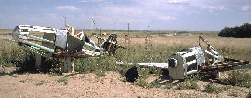
A 9/17/00 photo by AirNikon of what appears to have been 2 homebuilt aircraft, abandoned before their completion.
The photo was taken behind a gas station adjacent to Aurora Airpark.
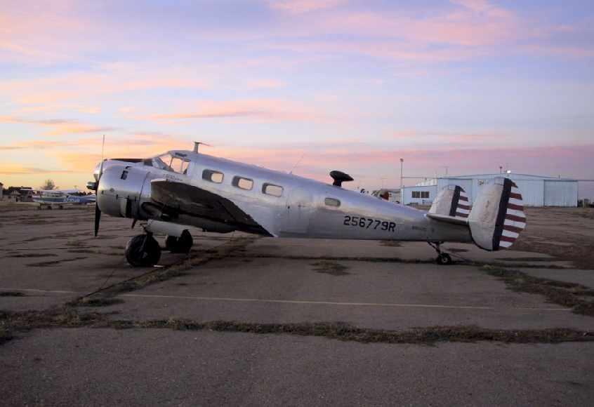
A beautiful sunset picture by Fabian Lorentz of a Beech 18 (N95622, "immaculate inside & out"), caught at Aurora Airpark on 10/19/01.
A September 2003 aerial photo by AirNikon looking west at the Aurora Airpark ramp,
with at least 10 aircraft visible parked outside.
![]()
An 11/9/03 photo by Craig Mills, departing from Aurora Airpark's Runway 14 in a Piper Arrow.
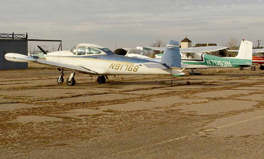
An 11/9/03 photo by Craig Mills of a Navion & 2 Cessnas at Aurora Airpark.
The last photo which has been located showing aircraft at Aurora Airpark was a 4/15/04 aerial view looking southwest,
in which the number of aircraft visible on the field had dwindled to only 9.
A 6/3/04 photo by Craig Mills looking southeast along Aurora Airpark's Runway 14 in its final days.
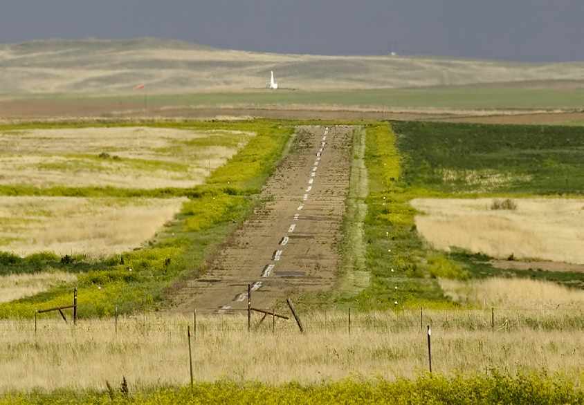
A 6/3/04 photo by Craig Mills looking southeast along Aurora Airpark's Runway 14,
with the Falcon VOR visible in the background.
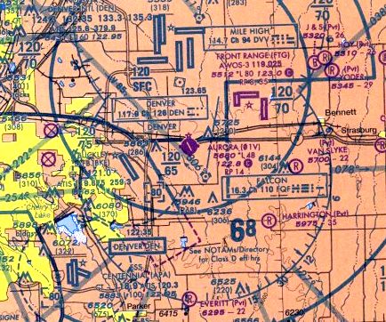
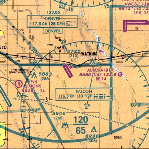
The last aeronautical chart depiction which has been located of Aurora Airport was on the 2004 Denver Sectional Chart (courtesy of Jonathan Westerling).
It depicted Aurora as having a 4,800' paved runway.
Scott Krugerud recalled of Aurora Airpark, “My family kept our Cessna 210 there until it closed, forcing us to move to nearby FTG.
While our plane is better off for it (FOD from gravel on the runway = prop that looks like a cheese grater), I miss the place.
It was run like a small town, everybody knew each other.
Many different activities took place there other than aviation.
We were allowed to shoot trap off the end of one of the dirt runways,
our only warning was to 'not shoot any planes'.”
Unfortunately, the pace of suburban development caught up with the little Aurora Airpark in 2004, as explained by Craig Mills:
"I only know about the field closing because my friend based his Arrow there.
He's flown out of there for a long time & because it is a privately owned airport,
there has been lots of interest in eventually developing it into some kind of commerce buildings.
The sticking issue was water rights, but those just recently got cleared up, so the go ahead to close the field has been given.
The date of closure is 6/15/04."
The closure of Aurora Airpark was also probably somewhat precipitated by the construction of the huge new Denver International Airport,
located a mere 5 miles to the north of the little Aurora Airpark.
The little airport was also situated underneath DIA's Class B airspace,
which came down to only 200' above Aurora's traffic pattern altitude(according to Aurora pilot Richard Werry).
In its last year of operation (2004), the published data for Aurora Airpark
described the field as having a 4,800 asphalt Runway 14/32 (which was unfortunately described as "in poor condition;
Pavement surface uneven with loose aggregate from Runway 14 end to midpoint"),
as well as a 2,300' turf/dirt Runway 8/26 (described as "in fair condition").
It is sad to see this airport going away - as it was obviously well used,
with a total of 78 aircraft listed as being based on the field (including 3 multi engine aircraft & 1 helicopter),
and the field was said to conduct an average of 60 takeoffs or landings per day.
Bob Resling reported that at the time of Aurora's closure, “It was the oldest continuously operated airport in Colorado at the time.”
A 9/18/04 photo by Craig Mills looking northwest at the abandoned Aurora Airpark.

A sad 9/18/04 photo by Craig Mills, looking north at the abandoned hangars of Aurora Airpark.
Scott Krugerud reported in 2005, “My family & I still take our dogs out there to run in the open space.
As of yet, no construction has started and it will be some time until it does.
There is trash everywhere, mostly leftovers from the cheap hangars.
My understanding is that is the reason the airport was closed. It had been for sale for many years.
The zoning commission in Arapahoe county had petitioned to rezone quite some time before, but nothing was ever done.
I heard that the property owners did not appreciate the trash (broken down cars, RVs, and just plain junk) that had collected on the premises
The junk is still there, but the planes are gone. Most of the hangars are gone now.
Only the shells of the tin roofed hangars next to Runway 14 are still there.
When the large hangar was brought down, all of the insulation & junk from inside was allowed to blow across the property.”
“In my opinion, the property is going to sit for some time.
I cannot imagine some investor looking to build a subdivision there with all of the cleanup
while there is virgin farmland on all sides that is also for sale.
The thought of living under the approach path for 35L at DEN would be somewhat less than appealing too.”
Heath Kennedy reported in 2005, “A preliminary development plan was approved by Arapahoe County
that allows for a mixed-use commercial, retail and residential development
to occur on roughly 900 acres that also includes the site of the old airport.
Construction should start within the next 2 years & is scheduled for a 10-15 year buildout.”
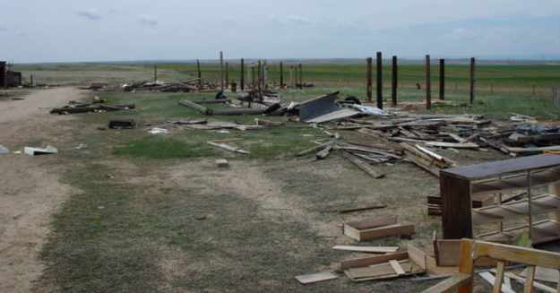
A 2005 photo by Keith Wood, of “what's left of the row of hangars on the west edge of the field.
There were some powered parachutes flying when I was there.”
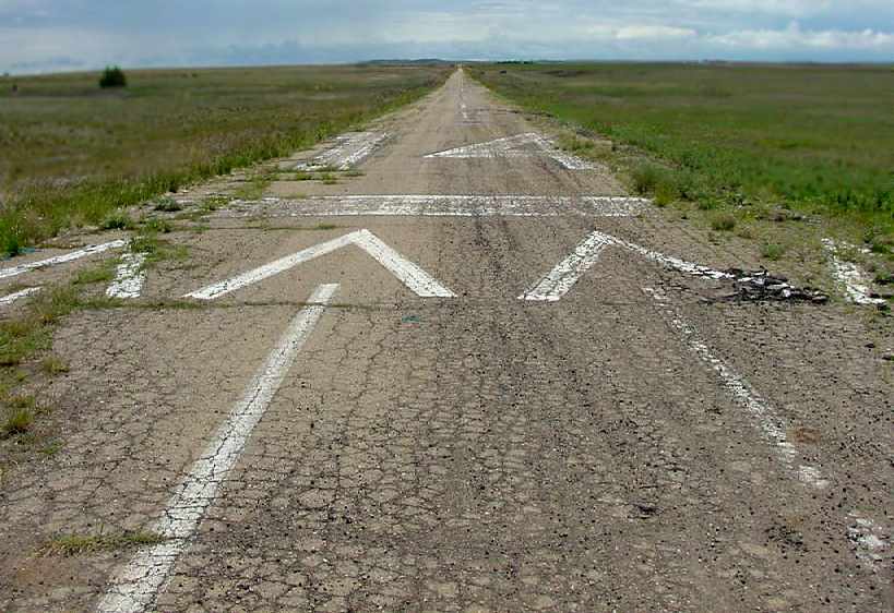
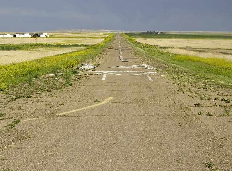
A 2006 photo by Patrick Griffith looking southeast along the former Runway 14 of Aurora Airpark.
Patrick Griffith reported in 2006, “I stopped by the old Aurora Airpark site today.
Not much has happened there recently. All of the old structures are down.
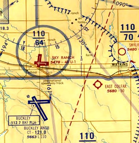
There was a large Public Notice sign giving notice of a plan to build the 'Sky Ranch Wastewater Treatment Plant'.
There was also a sign announcing the 'Neighborhood of Sky Ranch' coming soon
[which is somewhat confusing, given that 'Sky Ranch' is the name of another former airport, located somewhat to the northeast].
What a great place this would be for ultralight & powered parachute operations!”
A circa 2006 aerial view looking south along Aurora's Runway 14, showing the wreckage from demolished hangars.
A circa 2006 aerial view looking south at the foundations of Aurora's former hangars.
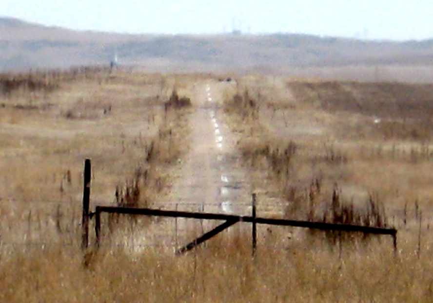
A March 2008 photo by Raymond Cober looking southeast along the former Runway 14 of Aurora Airpark.
Raymond observed, “Despite the poor condition of the runway
it looks like the only difference between this & when the airport was still active was that the grass was trimmed!
I remember my flight instructor forbidding me to do touch & go's on the runway because of its poor condition, just months before it was closed.”
A March 2008 photo by Raymond Cober of the site of the gas station which used to sit adjacent to the Aurora Airpark,
where the 2 abandoned half-built kitplanes were located (in preceding photo).
Raymond observed, “The gas station also included a BBQ restaurant,
both of which had been abandoned for as long as I can remember, long before the airport's closure.
Like most of the airport structures, this site has been nearly completely removed as well.
A man by the name of Shawn Dougan (who happens to work at nearby Front Range Airport) came by & gave me more information.
We exchanged the usual aviation knowledge & camaraderie,
and he told me that there was a radio-controlled airplane club that had been active during the airport's operation,
and they still were, operating out of a purpose-built mini-airfield adjacent to the property [east of the airport].
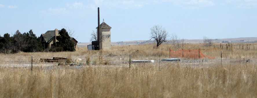
Beyond the the large main hangar with its adjacent offices would've been visible.
In the background you can see a house & a tower along with a clump of trees.
I don't know what purpose the house & tower served in relation to the airport,
or whether or not their construction predates the airport or not.
I would guess the tower served to store grain or equipment, but it was sometimes jokingly referred to as the airport's ATC tower.
I do not recall if they were occupied when the field was in operation, but both were found in a derelict state when I photographed them.
The road that leads into the airfield bisects the clump of trees.
It was paved, but badly pitted & covered with nearly as many potholes as it had pavement.”
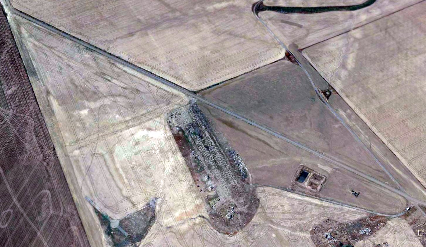
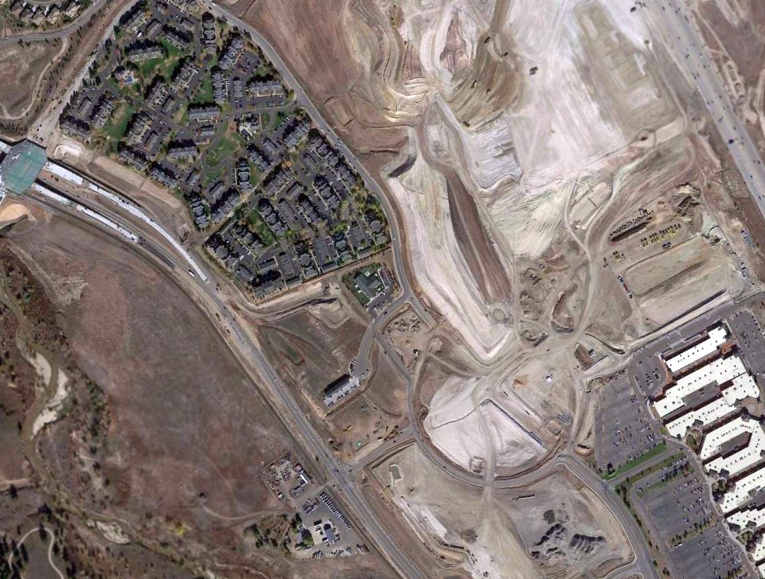
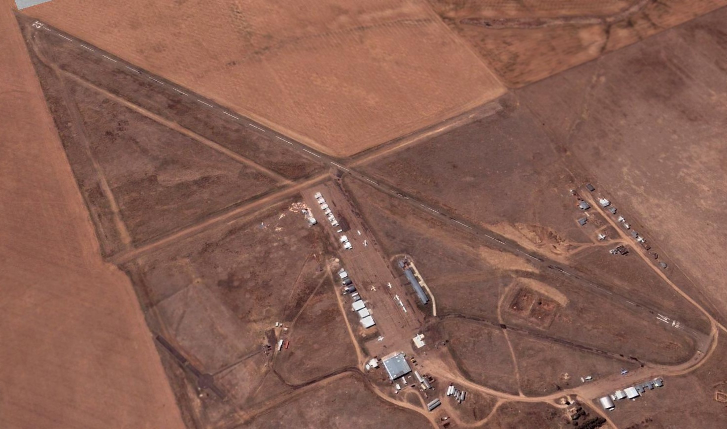
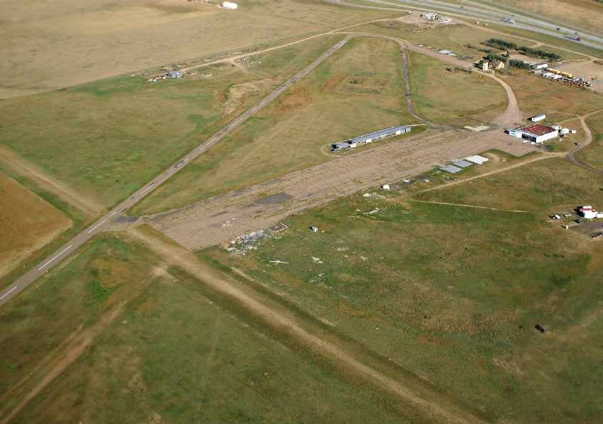
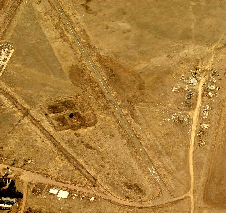
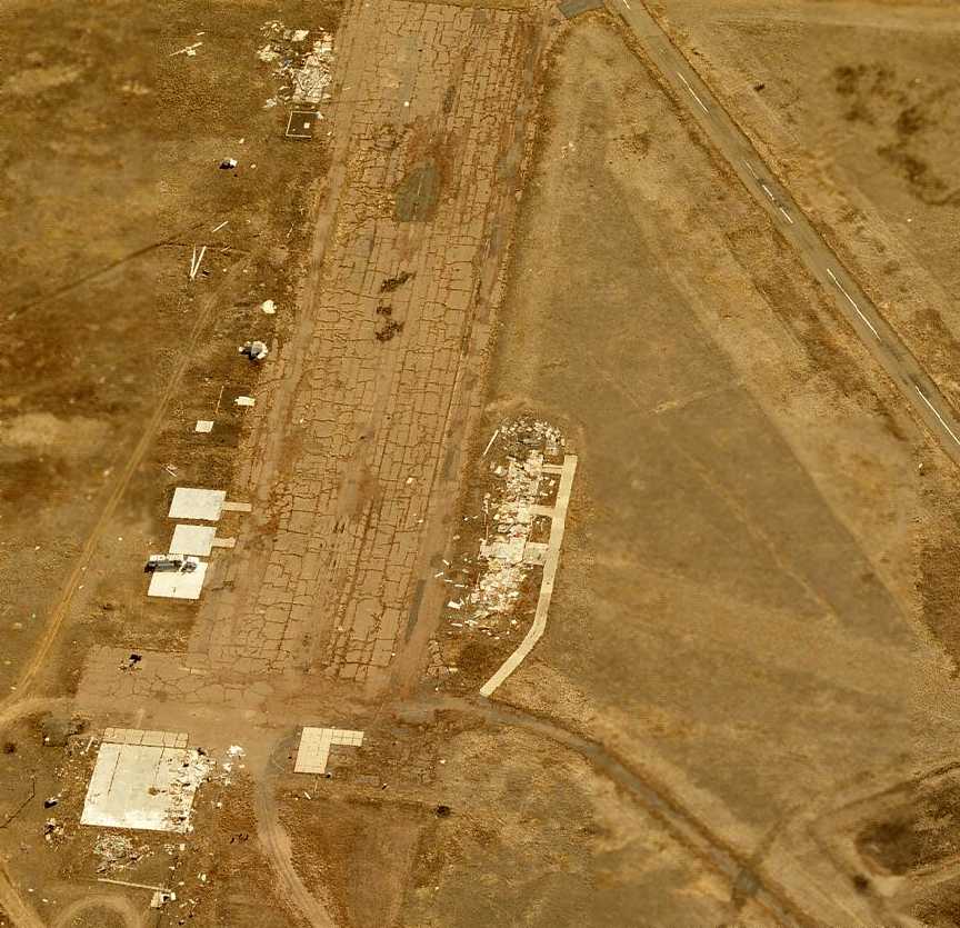
A sad sight for anyone who appreciates grassroots aviation: a 2015 aerial view looking southwest at the remains of Aurora Airpark,
showing the runway remains largely intact, but all of the buildings have been removed.
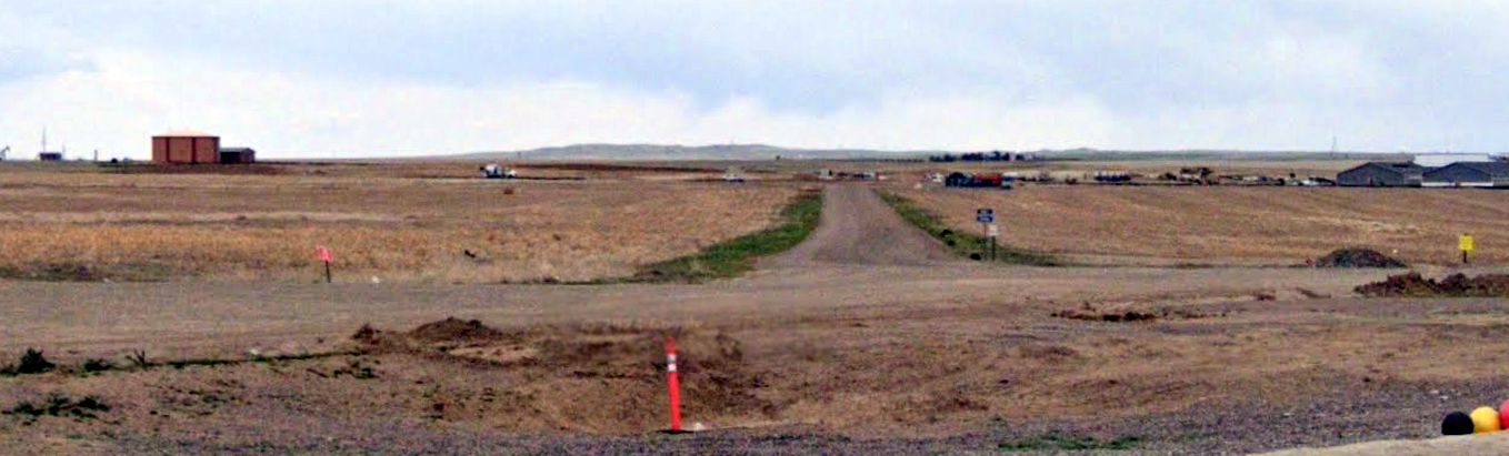
A 2023 photo looking southeast along the remains of the the Aurora Airpark runway.
A 2024 aerial photo showed the southern half of the Aurora Airpark runway had been removed by new construction, but the northern half remained.
Aurora Airpark is located at the southern terminus of East Colfax Road, along the south side of Interstate 70.
____________________________________________________
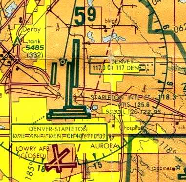
Lowry Field (2nd location) / Lowry AFB, Denver, CO
39.71, -104.89 (Southeast of Downtown Denver, CO)
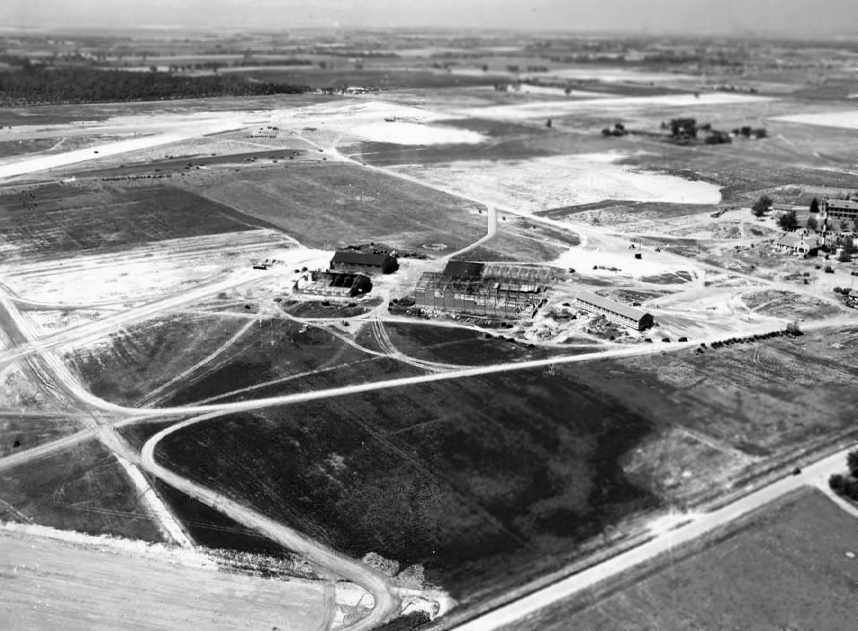
A 7/20/38 aerial view of Lowry Field (courtesy of David Brooks) showing the hangars & runways while under construction.
In 1934 the Army realized it was outgrowing its facilities at Chanute Field, IL
and began looking for a new facility where it could consolidate all of its Air Service Technical training schools.
After looking at more than 80 sites across the nation,
a military committee submitted a list to Congress with the names of 6 cities that would meet their needs.
Denver ranked first.
Congress approved the Air Corps project in 1937,
but Chanute remained the headquarters of the Air Corps Technical School & home to the aircraft mechanics school.
The Army formed a new branch for armament & photography training in Denver.
The Works Progress Administration began work on 10/4/37
to convert the grounds of the former Agnes Memorial Sanatorium into a modern airfield.
The new field was to be named in honor of Francis Lowry,
a Denver native who had been killed when he was shot down in 1918 while serving as an aerial observer.
Note that there was also a separate & unrelated airfield (4 miles to the northwest) known as"Lowry Field",
which was operated by the Colorado National Guard from 1924-38.
Once construction started on the new Lowry Field,
the Denver branch of the Army Air Corps became an Army post of 880 acres.
A bombing range of 64,000 acres was acquired in 1938.
In 1941, the Army acquired an additional 960 acres a few miles to the east
as an auxiliary landing field, and named it Buckley Field.
Classes at the new Lowry Field began on 2/28/38.
Ten students graduated from the Armament Department on 3/19/38.
Several months later, 10 photography students received diplomas in advanced aerial photography.
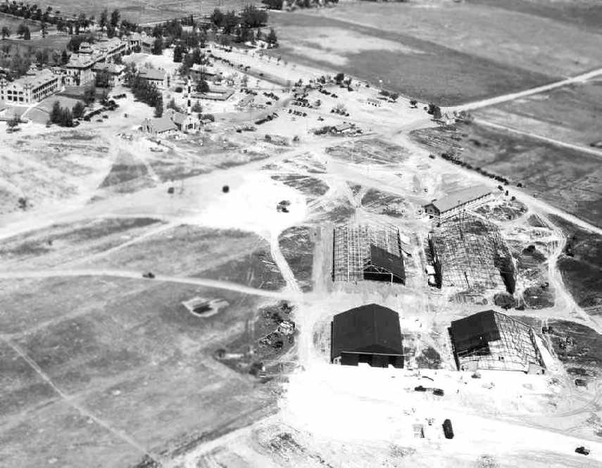
A 7/30/38 aerial photo (courtesy of David Brooks) showing the hangars & runways of the new Lowry Field while under construction.
While construction was underway, the Army kept aircraft assigned to the Denver branch at the Municipal Airport,
where they shared a hangar with the Colorado National Guard.
When Lowry’s first unpaved runway became operational on 4/4/38,
the first of 4 portable National Guard hangars was erected.
On June 30, nine aircraft flew from Municipal Airport to Lowry Field.
Construction continued & Hangar #1 was completed in August 1939,
and the 8,000' north/south runway was completed in December.
The first aircraft to land on the new, paved runway was a B-18A Bolo twin-engine bomber.
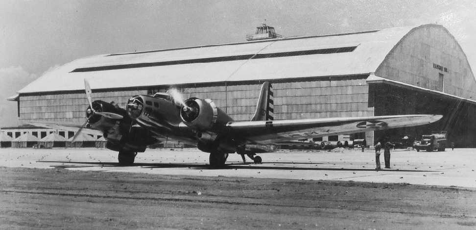
The earliest photo to be located showing an aircraft at Lowry Field was a 1939-40 photo of a Douglas B-23 Dragon bomber in front of a Lowry hangar.
In January 1940, Lowry Field had a complement of 44 officers, 1,350 enlisted men including 600 students, and 27 aircraft.
As the international situation worsened, the Army acquired additional land.
Following 12/7/41, the inflow of trainees increased.
In January 1942, the War Department tasked Lowry with annually training 57,000 men.
To accommodate the larger student population, construction of Lowry Field #2 was begun.
Lowry #2 was built on the northeast side of the post beyond 6th Avenue.
It opened in July 1942. In addition, Armament School #2 was established at Buckley Field.
Lowry trained only bombardment armorers while Buckley prepared armorers for fighter aircraft.
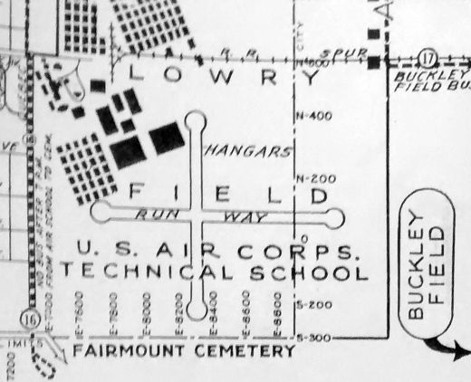
A 1943 street map (courtesy of Rex Ricks) depicted Lowry Field's original runway arrangement, with 2 perpendicular runways with several hangars to the northwest.
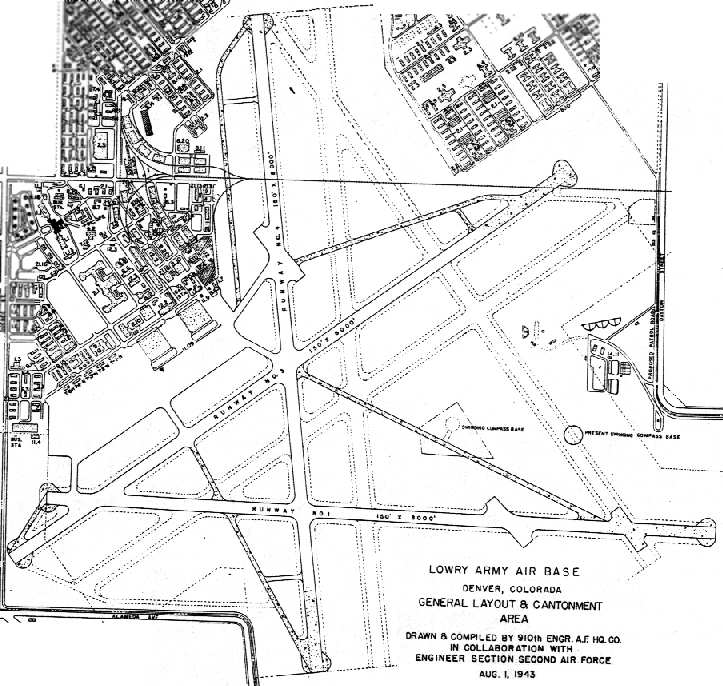
A 1943 2nd Air Force General Layout Plan (courtesy of John Voss)
depicted Lowry Field as having a considerably expanded runway configuration, with three 8,000' paved runways, taxiways, a ramp with 2 large hangars,
and a cantonment area with hundreds of buildings on the north side of the airfield.
The plan also depicted a planned addition of 3 other runways, but these were apparently never built.
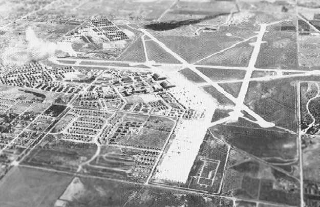
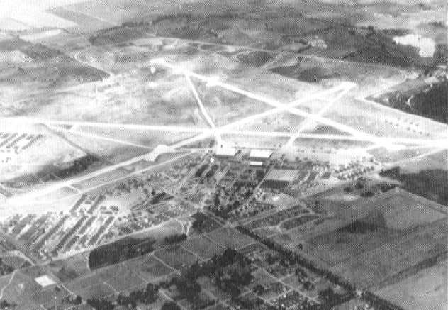
A 1943 aerial view of Lowry Field.
In October 1943, Lowry Flight Engineers School was moved to Lowry.
In 1944, Lowry introduced courses in radar photography, autopilot maintenance, and B-29 crew training.
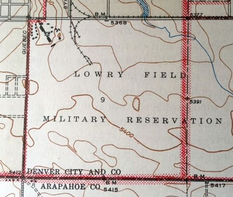
The 1944 USGS topo map (courtesy of Kevin Walsh)
depicted “Lowry Field Military Reservation” as a blank area, presumably due to wartime security concerns.
In April 1945, the Crash Fire Fighting & Rescue School moved to Lowry from Buckley Field.
Also in 1945, production of B-29 Superfortresses reached a level that necessitated another school for pilot & crew training.
Forty-two B-29s arrived at Lowry in May & the 6-week course began in July.
At war’s end, 2 classes remained at Lowry along with 39 Superfortresses. The classes never completed training.
The end of the war in Europe in May & V-J Day on August 15 ended Lowry’s short history as a pilot transition training school.
Lowry quickly returned to a peacetime schedule. Staffing decreased & student enrollment plummeted.
It became a separation center for returning veterans. By the end of the 1945, Lowry was processing an average of 300 discharges a day.
In 1948, with the postwar reorganization of the military, Lowry Field became Lowry Air Force Base.
The February 1945 Denver Sectional Chart (courtesy of Richard Doehring)
depicted Lowry as a military airfield.
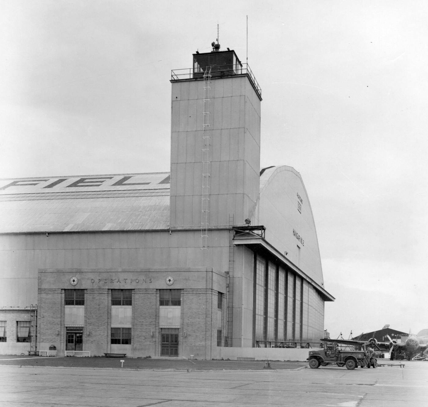
A 1946-49 photo by Bruce Reid (courtesy of Don Reid) of the Lowry Field Operations building, control tower, and Hangar #2.
Note the early-model B-17 at bottom-right.
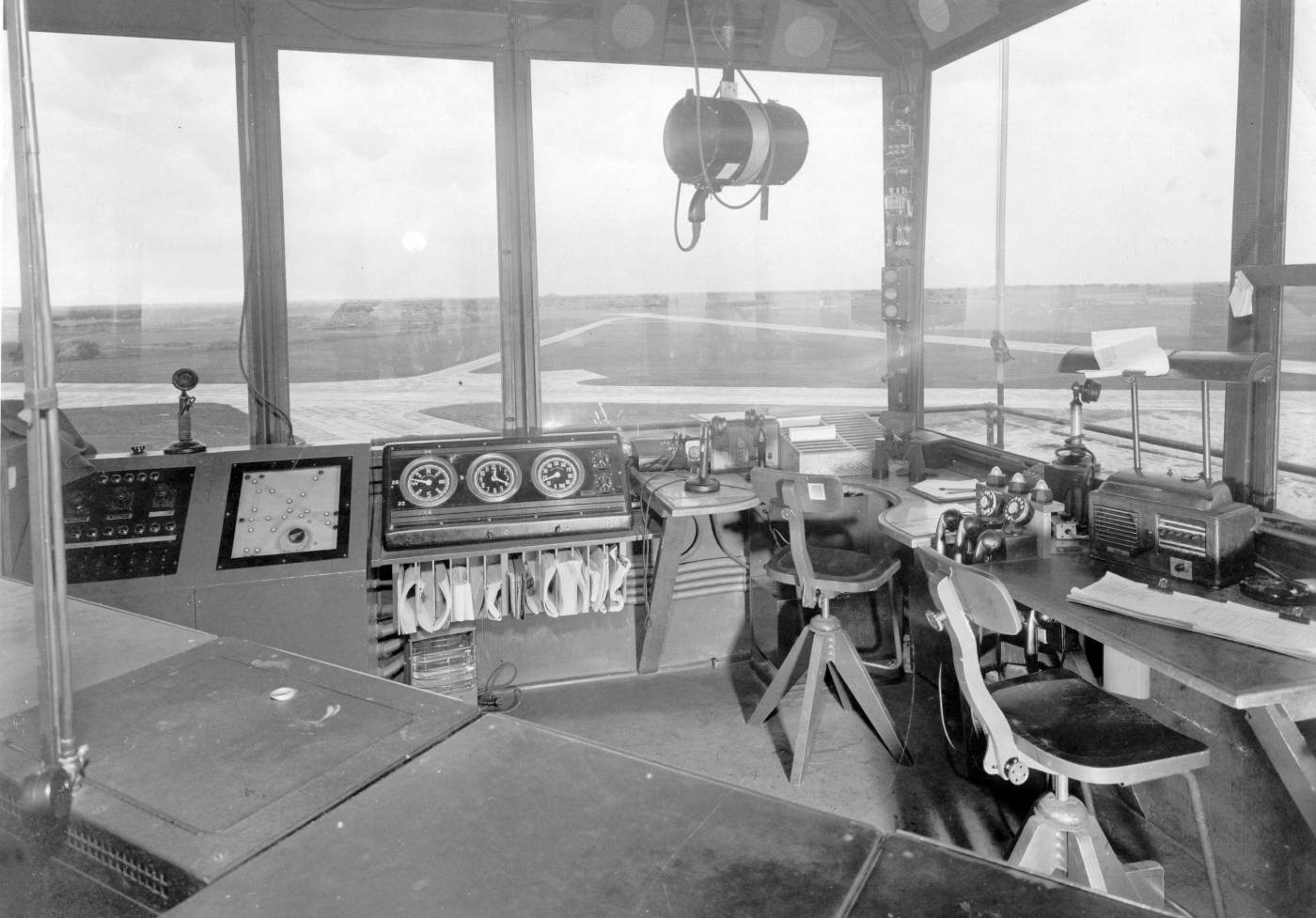
A 1946-49 photo by Don Reid (courtesy of Bruce Reid) of the interior of the Lowry Field control tower.
Bruce reported that his father, Don Reid, “was tasked with coming up with a standard console design for all towers of that era.
It was based on feedback provided by those tower operators from around the country. Their comments had a great impact on the final design.”
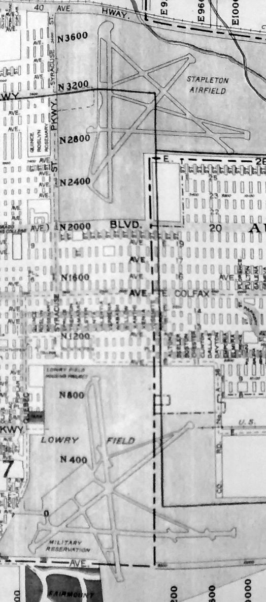
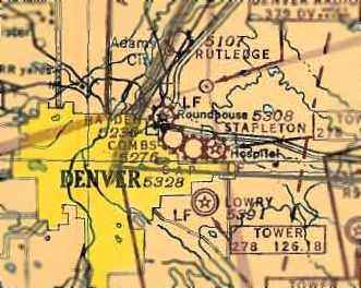
A 1948 street map (courtesy of Rex Ricks) depicted Lowry Field's proximity to Stapleton Airfield.
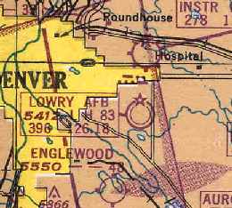
The February 1949 Denver Sectional Chart (courtesy of Chris Kennedy) depicted Lowry AFB as having an 8,300' hard surface runway.
Paul Goebel recalled, “Lowry Air Force Base... In 1951, there was heavy traffic of B-36 planes taking off & landing.
They had a unique sound with their combination of radial piston engines & jets.”
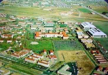
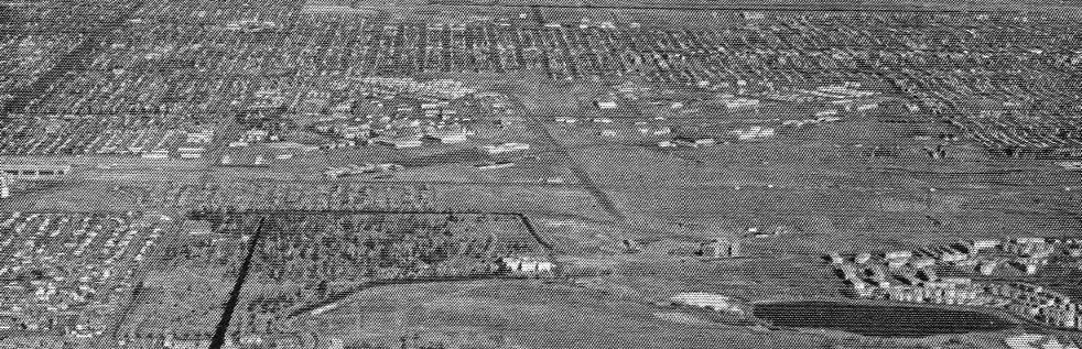
A 1950s postcard aerial view looking east at Lowry AFB (courtesy of Rex Ricks).
A 9/3/53 USGS aerial view depicted a large number of aircraft at Lowry AFB.
In 1954, President Eisenhower signed a bill authorizing an Air Force Academy.
Lowry was selected as the Academy’s interim home until construction was completed in Colorado Springs.
The first class of cadets arrived in July 1955.
Paul Goebel recalled, “Lowry Air Force Base... In 1955, it was being used by fighter jets.”
In the 1950s Lowry AFB immediately responded to the North Korean incursion with an expanded training program.
Courses taught, in addition to photography & armament,
included rocket propulsion, missile guidance, electronics, radar-operated fire-control systems,
computer specialties, gun & rocket sights, and electronically operated turret systems.
Lowry lost one of its traditional courses, aerial photography, in February 1956.
Changing technology in the form of remote-control cameras on reconnaissance aircraft
made aerial photography specialists redundant.
Programs in camera repair & ground photography, however, continued to be taught.
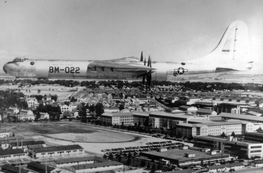
A circa 1950s aerial view of a massive Convair B-36 Peacemaker bomber overflying Lowry AFB.
The Air Force Academy occupied facilities at Lowry #2 until 1958.
The 1960s marked the end of an era at Lowry. The 3415thTechnical Training Wing became Lowry Technical Training Center.
Headquarters shifted from the Sanatorium buildings. Flight activity began to be phased out,
in part due to the dense encroachment of residential development around Lowry AFB,
which had made it increasingly unsuitable for flight operations.
The base was closed to all transient air traffic in June 1960.
The 451st Strategic Missile Wing operated 2 HGM-25A Titan I equipped missile squadrons from its Lowry support base.
The 724th Strategic Missile Squadron operated 3 missile sites from 2/1/60-1/25/65: 724-A, 724-B, and 724-C.
The 725th Strategic Missile Squadron operated 3 missile sites from 8/1/60-1/25/65: 725-A, 725-B, and 725-C.
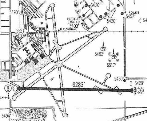
By the time of the 1960 Jeppesen Airway Manual (courtesy of Chris Kennedy),
Lowry was down to only a single remaining operating runway: the 8,283 paved Runway 8/26.
The two other abandoned runways were still depicted as well,
along with an extensive system of taxiways, ramps, and hangars.
In 1962, Lowry's Department of Weapons Training offered 60 courses in conventional munitions,
disaster control, armament, nuclear weapons, and weapons loading.
The Nuclear Weapons branch became the only Air Force organization
that instructed in storing, maintaining, assembling, testing, and handling nuclear components.
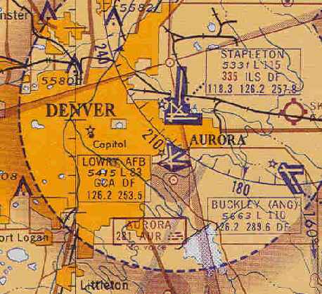
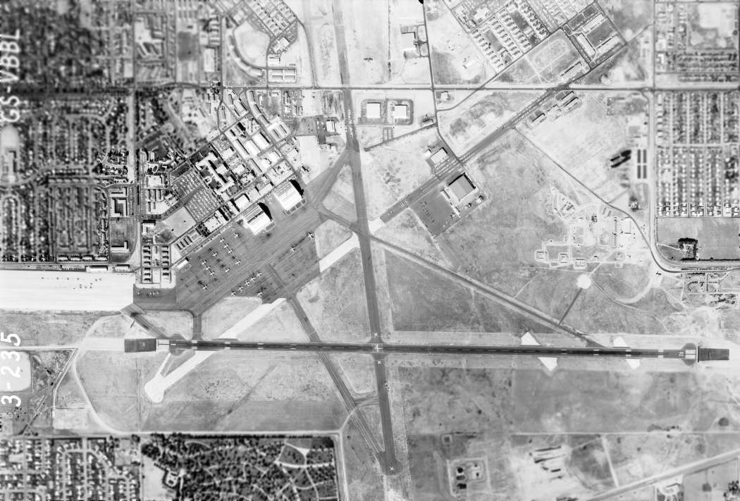
The June 1963 Denver Sectional Chart (courtesy of Chris Kennedy)
depicted Lowry AFB as having 3 paved runways, with the longest being 8,300'.
By 1964, Lowry's 3415th Technical School was graduating more than 10,000 people annually.
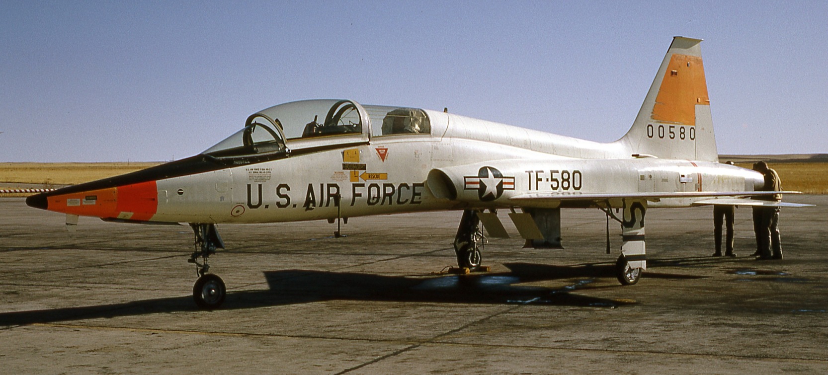
A 1964 photo by Irv Bjorkheim of a Northrop T-38 Talon trainer at Lowry AFB.
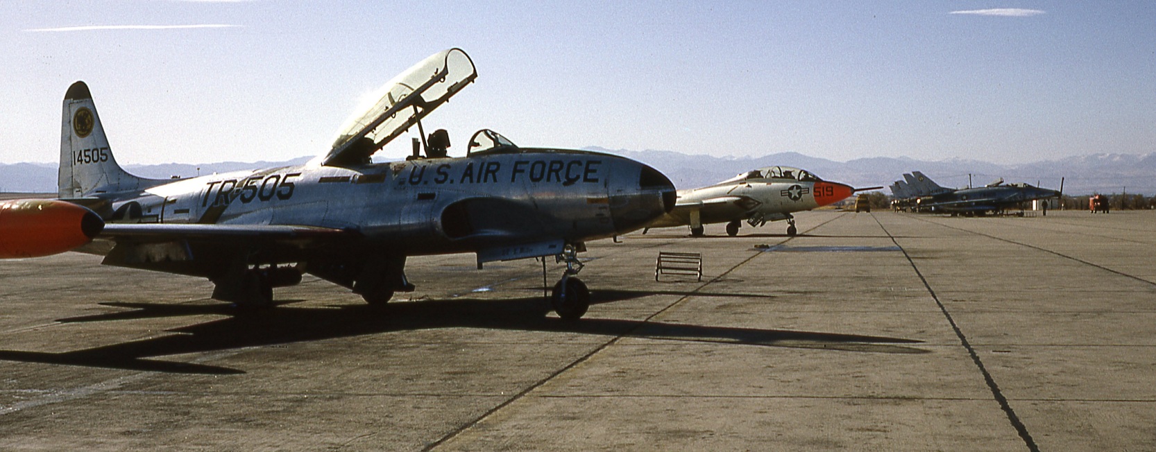
A 1964 photo by Irv Bjorkheim of a Lockheed T-33 Shooting Star trainer, a Grumman TF-9J Panther trainer, and a row of North American F-100 Super Saber fighters at Lowry AFB.
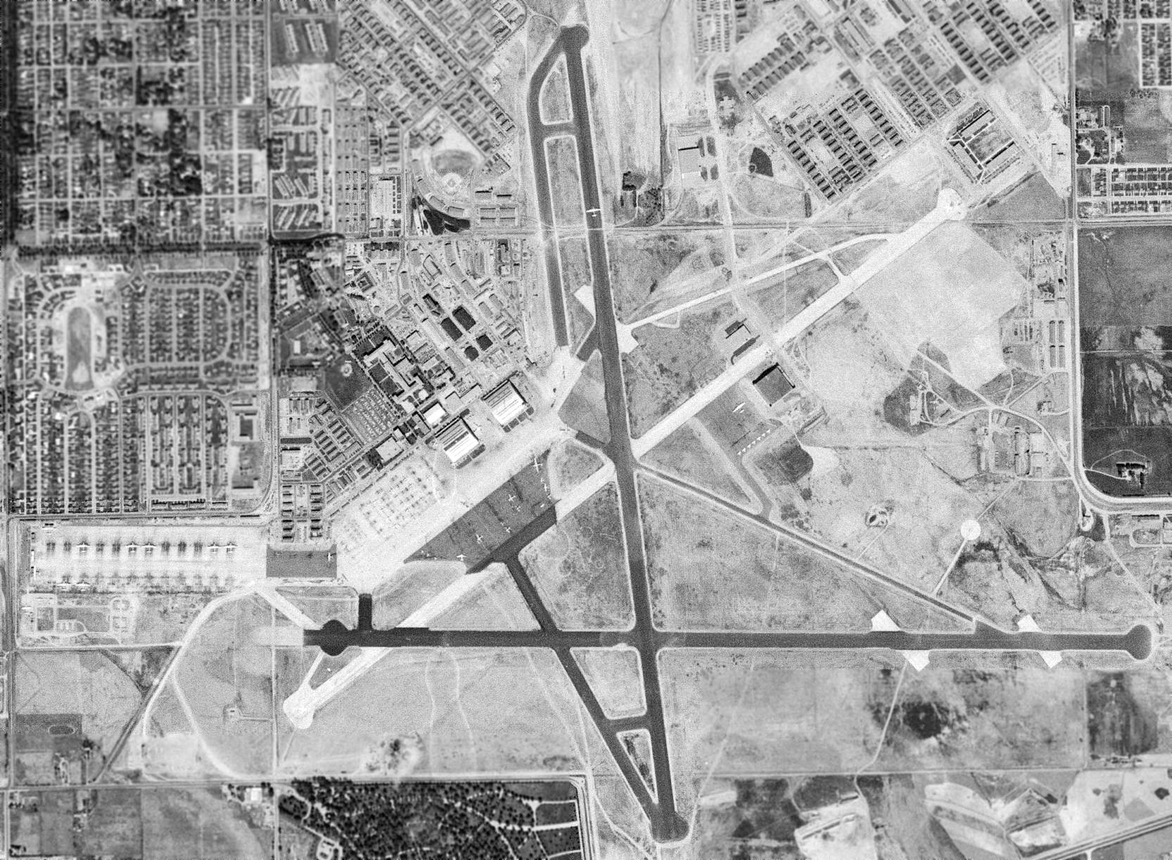
The last photo which has been located still showing aircraft operating from Lowry AFB was a 10/20/64 USGS aerial view.
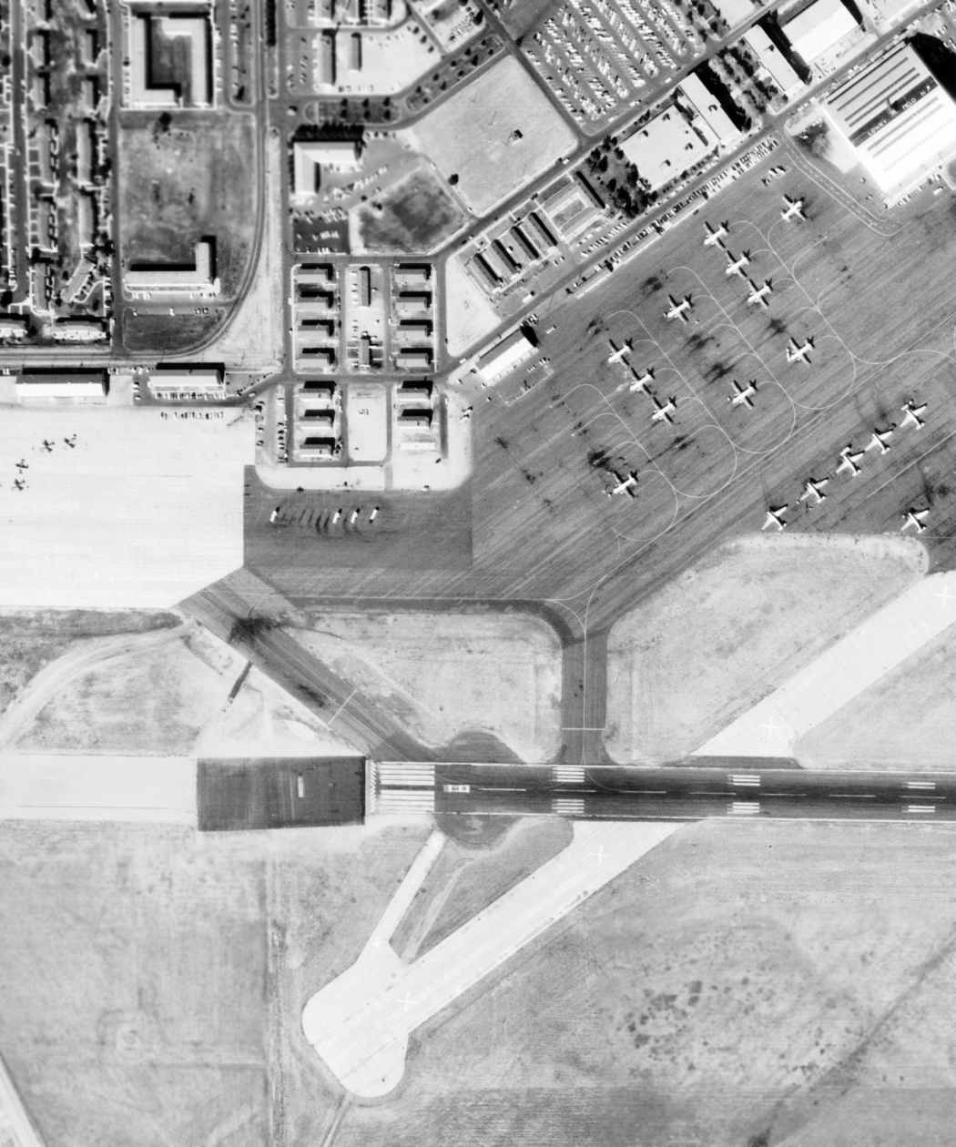
A closeup from the 10/20/64 USGS aerial view of Lowry, showing single-engine aircraft on the west ramp & larger twin-engine transports to the east.
In 1964 Lowry’s remaining flight operations were shifted to Buckley Field.
All Lowry flying activities ceased completely in June 1966 when the last T-29 was flown out of Lowry to Buckley.
By the time of the December 1968 Denver Sectional Chart (courtesy of Richard Doehring),
the 3 paved runways of Lowry were still depicted, but the field was labeled as Closed.
After the end of flight operations at Lowry, new programs were added.
Intelligence training returned, and airmen were trained for the Southeast Asia conflict.
The look of Lowry began to change in the 1970s. Almost 200 WW2-era wooden buildings were replaced with brick structures.
The new facilities included five dormitories housing 1,000 people each, a youth center, a child-care center, a chapel, an Airmen’s Open Mess,
and 5 buildings for the 3320th Correction & Rehabilitation Group.
To put more emphasis on technical training & the aerospace mission, the Air Training Command reorganized its schools in 1972.
The 3415th Technical School became the USAF School of Applied Sciences - Lowry,
comprised of Avionics, Aerospace Photography, Aerospace Munitions, Special Instruments, and Logistics departments.
An undated aerial view looking north at Lowry AFB from the 1976 CO Airport Directory (courtesy of Alex Hauzer).
The February 1977 Denver Sectional Chart (courtesy of Chris Kennedy) still depicted the 3 former runways of Lowry AFB,
but the airfield was labeled as “Closed”.
In 1977, the Air Training Command was realigned along more traditional military lines.
Lowry’s school became the 3400th Technical Training Wing. The training departments became technical training groups.
They were the 3420th Intelligence, 3430th Audiovisual, 3440th Logistics, 3450th Avionics, and 3460th Munitions groups.
The basic wing-group structure continued into the 1980s.
Lowry first faced the possibility of base closure in 1978, but Air Force recommended keeping Lowry open.
With the base closure issue settled (for the time being),
Lowry Technical Training Center introduced new & improved courses for the 1980s.
Lowry became the primary training center for space operations courses & began Undergraduate Space Training for officers.
Lowry also handled ground & armament training for the F-15, F-16, A-10, and B-1 bomber, as well as the Short Range Attack Missile (SRAM).
Lowry was also instrumental in training munitions handling for modified B-52 bombers.
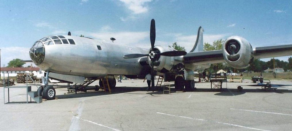
A 1987 photo of a Boeing KB-29 Superfortress of the Wings Over The Rockies Air & Space Museum at Lowry AFB.
On 10/1/87, Lowry observed its 50th anniversary.
The June 1989 Denver Terminal Chart (courtesy of Robert Brown) depicted still depicted the layout of Lowry's 3 runways.
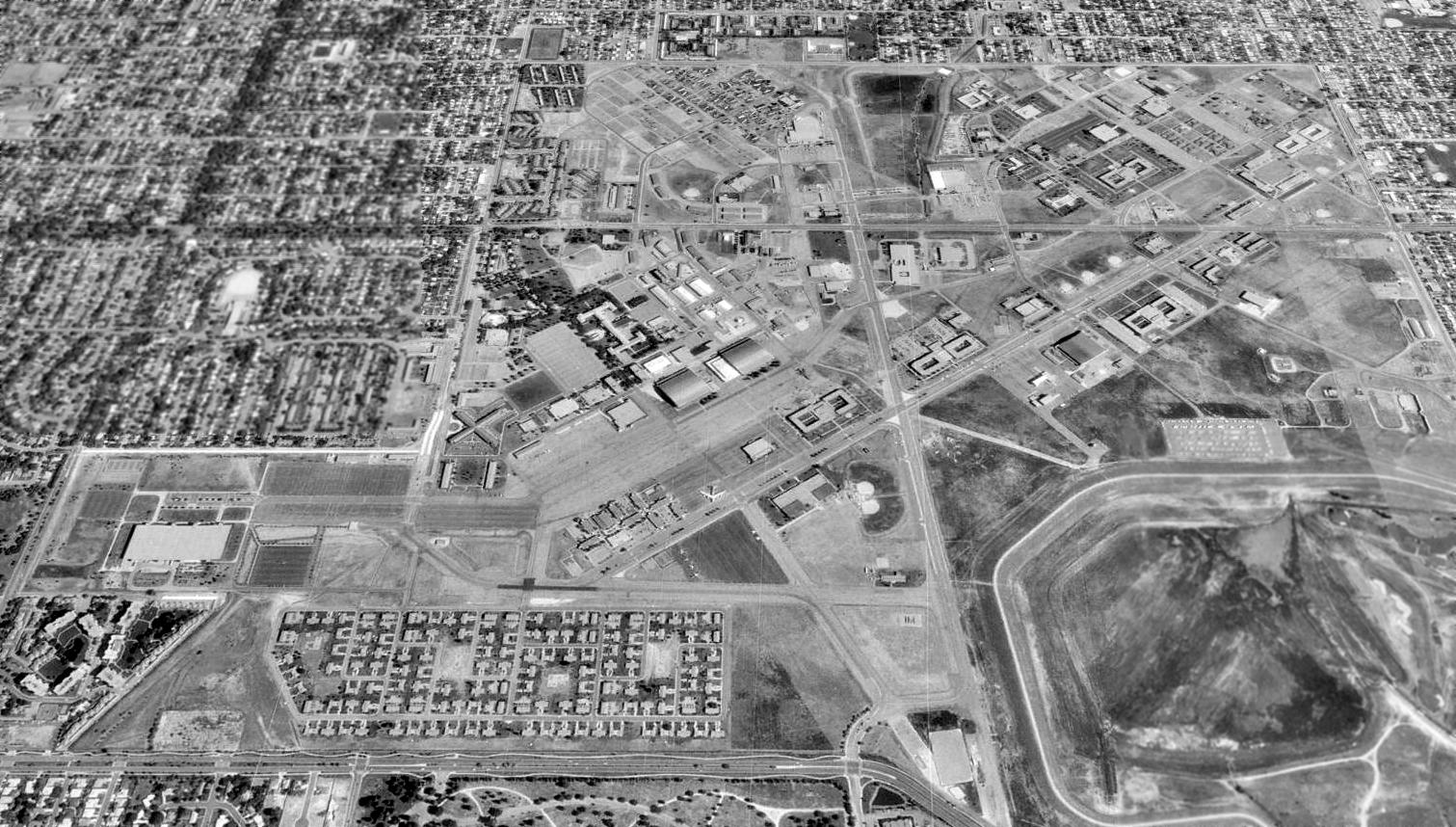
A 1993 USGS aerial view looking north showed the characteristic layout of Lowry AFB's former runways was still apparent.
The last aircraft to remain on the base after its runways were closed was a single B-52B bomber, visible in the center of the photo.
Characterized by more reorganization, the 1990s saw the beginning of the end at Lowry.
The end of the Cold War, along with the resultant budget cuts & downsizing made base closure a reality.
In 1993, Lowry prepared to end 56 years of technical training.
While training continued, Lowry’s command structure planned to implement the closure in an efficient manner.
The Air Force deactivated the 3400th Technical Training Group on 4/27/94.
A parade & pass-in-review was planned,
but the death of former President Richard Nixon caused the ceremonies to be postponed to the 28th.
The official deactivation date, however, remained the 27th.
On 9/30/94, the American flag came down for the last time at Lowry AFB,
almost 57 years to the day that it was first raised at a new base.
A non-profit foundation was created to form the Wings Over The Rockies Air & Space Museum
which opened in the former Hangar #1 in 1994.
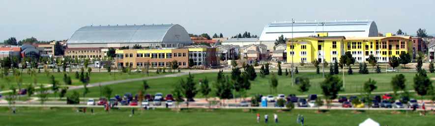
Today houses, office buildings, businesses, and paved streets
cover the land once occupied by hundreds of acres of concrete runways.
The only remaining hangar is presumably the former Hangar #1, which continues to house the museum.
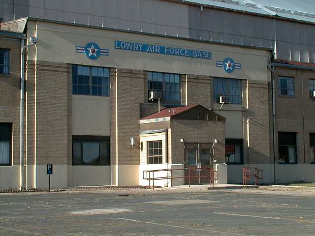
A recent photo of a restored hangar at Lowry.
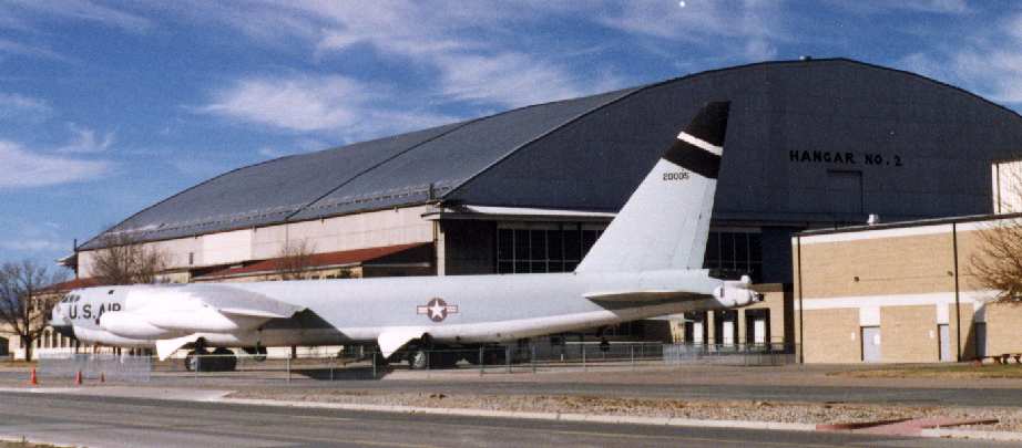
A 1999 photo by Lou Thole (author of the book "Forgotten Fields of America")
of a B-52 on display in front of Lowry's Hangar 2.
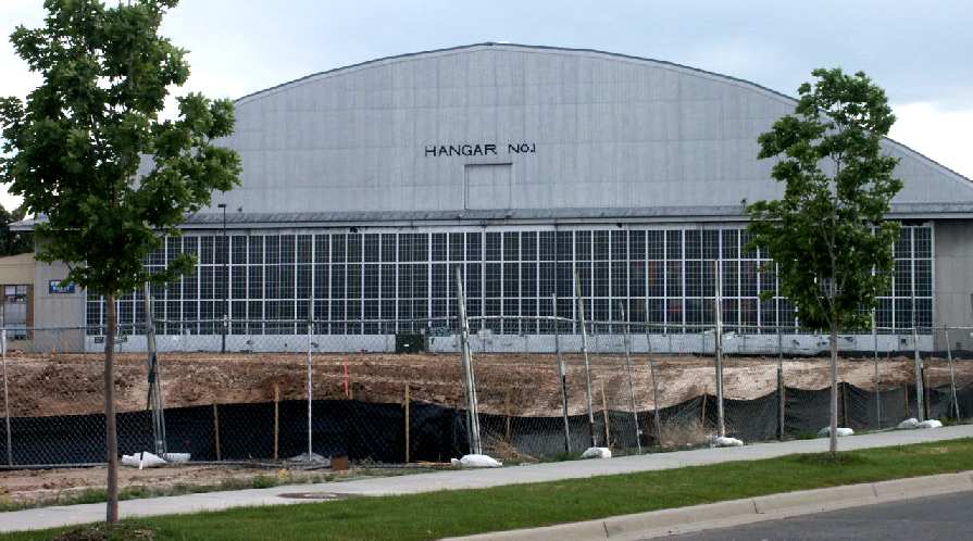
A 2002 photo by Tim Tyler of Lowry's Hangar #1.
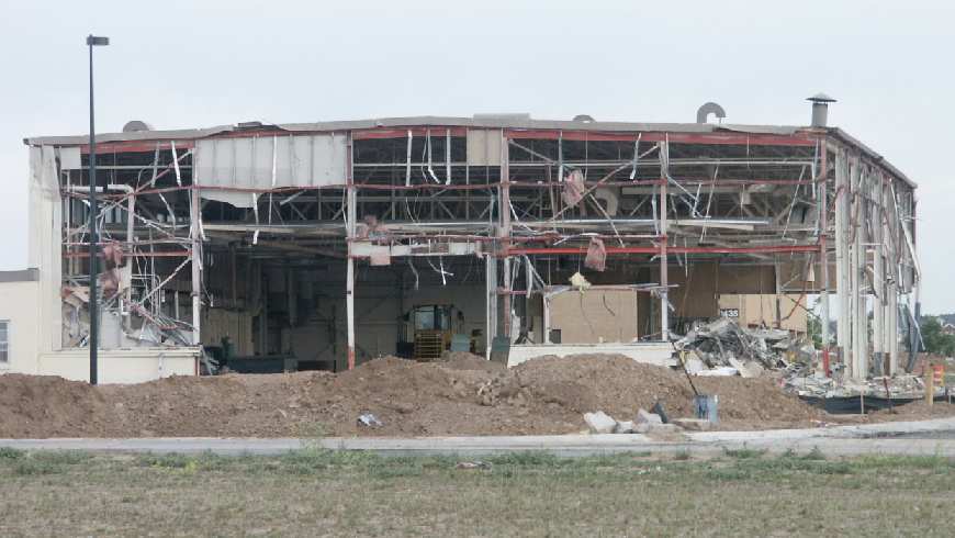
A 2002 photo by Tim Tyler of a building which was being demolished,
along the former flight line adjacent to Hangar #1.
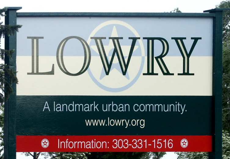
A 2002 photo by Tim Tyler of a sign at the development which is being built over a portion of the former Lowry AFB.
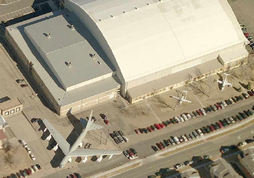
A circa 2006 aerial view looking north at a B-52, an Adam A500, and a Learjet on display in front of Lowry's Hangar 1.
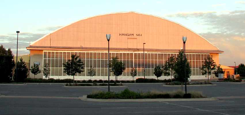
A 2007 photo by Scott Murdock of Lowry Field's former Hangar 1.
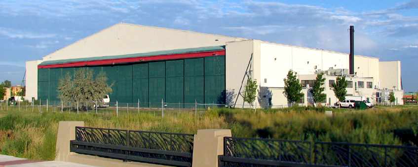
A 2007 photo by Scott Murdock of another former Lowry Field hangar.
A 2007 photo by Scott Murdock of 2 former Lowry Field hangars.
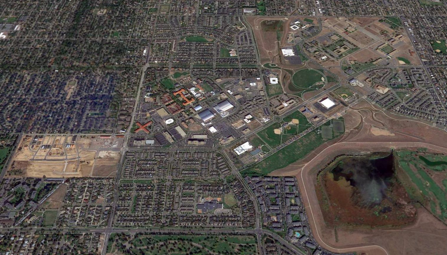
A 2015 aerial view looking north showed that none of Lowry AFB's runways remain,
but several hangars & a static display B-52B bomber are visible in the center of the photo.
____________________________________________________
Since this site was first put on the web in 1999, its popularity has grown tremendously.
If the total quantity of material on this site is to continue to grow,
it will require ever-increasing funding to pay its expenses.
Therefore, I request financial contributions from site visitors,
to help defray the increasing costs of the site
and ensure that it continues to be available & to grow.
What would you pay for a good aviation magazine, or a good aviation book?
Please consider a donation of an equivalent amount, at the least.
This site is not supported by commercial advertising –
it is purely supported by donations.
If you enjoy the site, and would like to make a financial contribution,
you
may use a credit card via
![]() :
:
Please consider checking the box to make a monthly donatation.
For a mailing address to send a check, please contact me at: paulandterryfreeman@gmail.com
If you enjoy this web site, please support it with a financial contribution.
please contact me at: paulandterryfreeman@gmail.com
If you enjoy this web site, please support it with a financial contribution.
____________________________________________________
This site covers airfields in all 50 states.