
Abandoned & Little-Known Airfields:
California: Tulare County
© 2002, © 2024 by Paul Freeman. Revised 7/31/24.
This site covers airfields in all 50 states: Click here for the site's main menu.
For the 6th year, the CA pages of this website are sponsored by the California Pilots Association:
____________________________________________________
Please consider a financial contribution to support the continued growth & operation of this site.
Alta Airport (revised 9/6/23) - Green Acres Airport (revised 7/31/23) - Pixley Airport / Harmon Field (revised 2/12/24)
Rankin Field (revised 2/13/24) - Synanon Airfield (added 5/4/24) - Tunnel Meadows Airport (revised 9/6/23) - Wonder Valley Airport (revised 2/13/24)
____________________________________________________
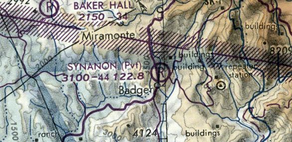
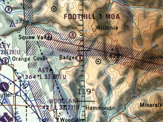
Synanon Airfield, Badger, CA
36.642, -119.01 (Southeast of Fresno, CA)
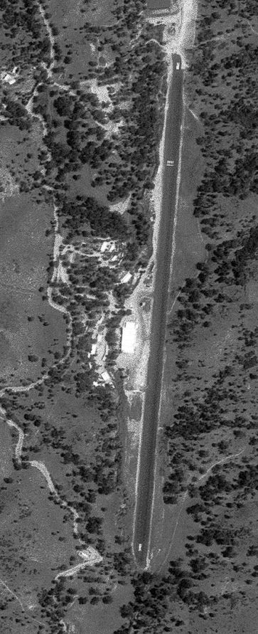
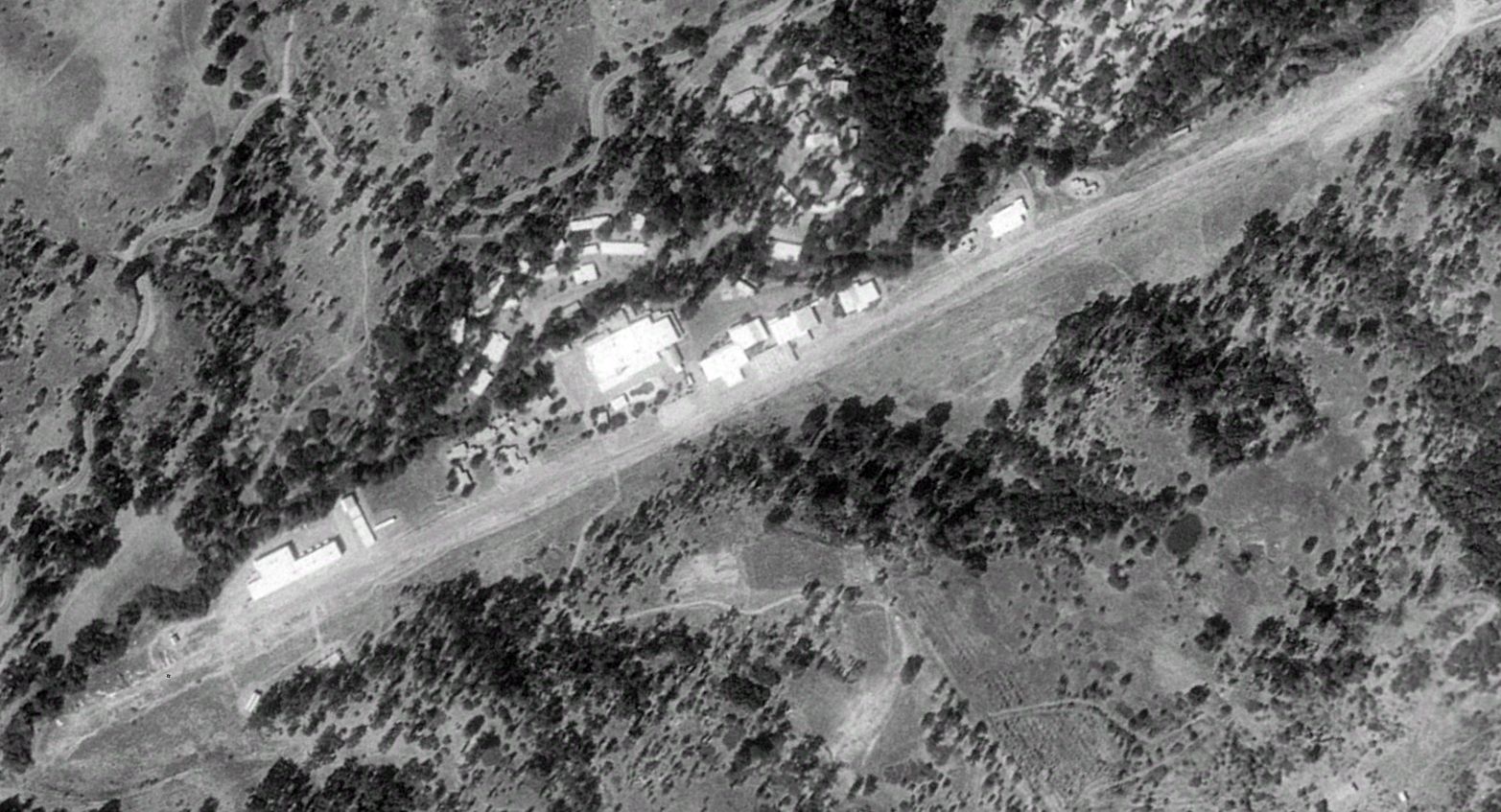
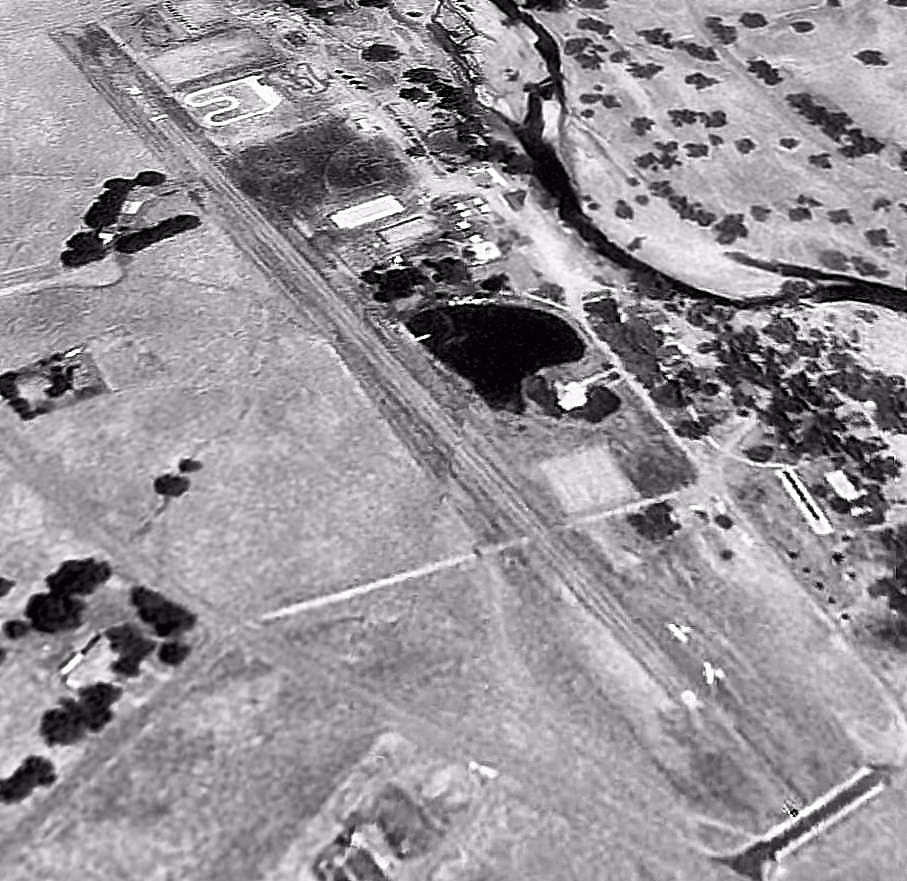
Synanon Airport, as depicted on a 6/2/77 USGS aerial view.
This private airfield eventually became used by a notorious cult.
Jonathan Westerling reported, “In 1944 (according to information in a later lawsuit) James Stapp got approval from the Tulare County Board of Supervisors for an airport on his ranch.
In 1945 the Civil Aeronautics Administration approved his airfield as a 'Designated Landing Area'
and the 1949 Tulare County's 'Master Plan of Airports' depicted the location of the Badger Airport as an approved proposed site for a recreational/emergency airport.
It did not appear the airport was significant enough to be listed in any directories [nor depicted during its early days on aeronautical charts or topo maps], but was used as a landing strip for agricultural flights from 1951-61.”
The earliest depiction which has been located of Synanon Airport was a 1957 aerial view, which depicted an unpaved 2,400' north/south clearing.
But there were no hangars, aircraft, or other specific signs of an airfield.
Jonathan Westerling reported, “After [1961] the field was used for agriculture until the land was purchased by Synanon.”
No airfield was depicted at this location on the 1967 USGS topo map.
Jonathan continued, “Founded by Charles Dederich, Synanon was a radical approach to treating society's most troubled individuals. It was also effective at advertising and raising donations.
Just 10 years after its founding, Synanon boasted at least 1,100 members, was receiving $2.5 million a year in donations & had purchased numerous properties to be used as treatment centers.
One of these properties was built in the mountain town of Badger. Stapp sold his ranch to Synanon in 1976 & they filed for a permit to expand & pave the airfield.
A 7/22/76 Tulare Register article detailed the group's application to construct a runway over the opposition of several Badger residents.
Synanon argued that the County's Master Plan specifically recommended establishing an airfield at this location as an emergency landing location for when the central valley gets fogged in - a not-infrequent summer occurrence.
The same article noted Synanon as owning 9 planes, but 3 of which were kept in Woodlake - 40 minutes from their Badger facility.
Synanon proceeded with the airfield's construction despite the objections, and then withdrew their permit when it became evident that one of the County commissioners was pushing to have the 'fog free' airfield constructed in his supervisory district.”
Jonathan continued, “Not much has been preserved about how Synanon used their airplanes & gliders which numbered 12 by the end of 1976 (according to an LA Magazine article).
A 1977 Fresno Bee article touted Synanon's 'Good Neighbor Policy' & noted that 'Synanon's privately operated mile-long airstrip located at The Strip is also available for emergency daytime landings.
Airfield personnel monitor 122.9 Mhz during daylight hours. The facility located at 3,130' altitude is generally fog-free when most Valley airfields are fogged in.'"
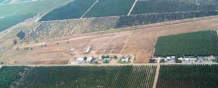
A 6/2/77 USGS aerial view depicted Synanon Airport as having a single asphalt north/south runway, with a large building along the west side, but no aircraft were visible.
Jonathan continued, “On 5/25/77, the Tulare County Board of Supervisors adopted a resolution directing the district attorney to file a lawsuit against Synanon for constructing an airfield without the required permits.
According to the case, Synanon's investment in the land & improvements for the airport was approximately $1.5 million & included a 4,500' asphalt runway, large adjacent hangars, and several buildings.
The trial was lost by Synanon & an injunction was issued on the airfield's operation.
But Synanon appealed a year later & won, mainly because they argued the harm to aviation by closing the airfield would be far worse than the harm caused to the County by its continued operation.
The presiding judge wrote in his opinion: 'Whether or not we agree with appellant's charitable & religious purposes and its business methods, it made a strong showing of interim harm if the injunction should [be issued].
Their declarations show that the suspension of flights would jeopardize appellant's educational activities & the expeditious transporting of its members to & from its Badger facilities.'”
The earliest aeronautical chart depiction which is available of Synanon Airfield was on the 1979 San Francisco Sectional Chart (courtesy of Jonathan Westerling).
It depicted Synanon as a private airfield with a 4,400' unpaved runway.
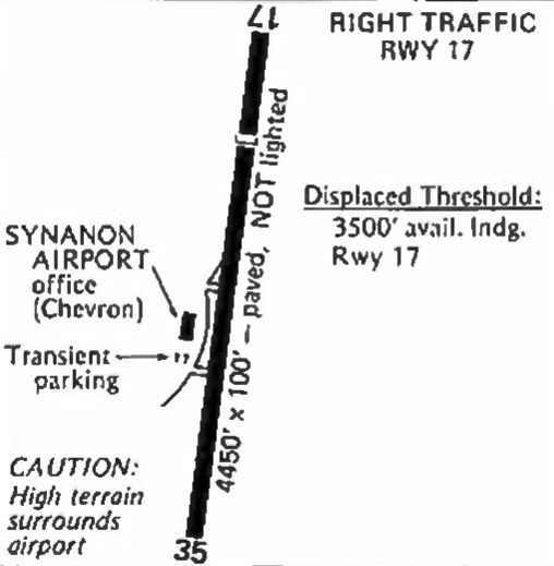
The Synanon Airport was first depicted in the 1979 Pilot's Guide to California Airports with a note: "Synanon Airport is not normally open to the public (runways are marked 'R' meaning Restricted).
However, the Synanon Foundation makes it available able for emergency use because at times of ground fog in the Central Valley, this airport at 3,100' may be the only field open for hundreds of miles."
Jonathan Westerling reported, “While Synanon's court victory ensured it was able to resume operation of its airfield, the organization itself was failing from within.”
In 1979, Dederich & 2 followers pleaded no contest to conspiracy to commit murder, and the Synanon leader was sentenced to 5 years’ probation.
The plea bargain required Dederich to give up control of Synanon. Without each other, Dederich & Synanon quickly lost their popularity."
The 1979 AOPA Airports USA depicted Synanon Airport as having a 4,510' paved runway, with fuel available along with minor repairs in an emergency.
Jonathan Westerling reported, “Synanon started to suffer financially without its founder & it lost its tax exempt status in May 1982.
However the airfield continued to operate & was listed on charts & directories with prior permission required to land.”
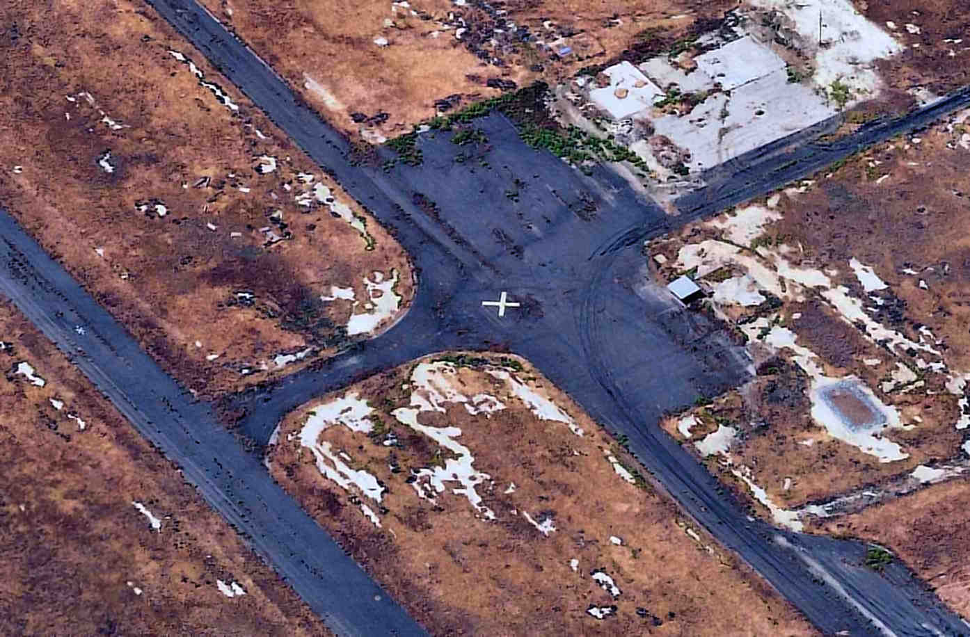
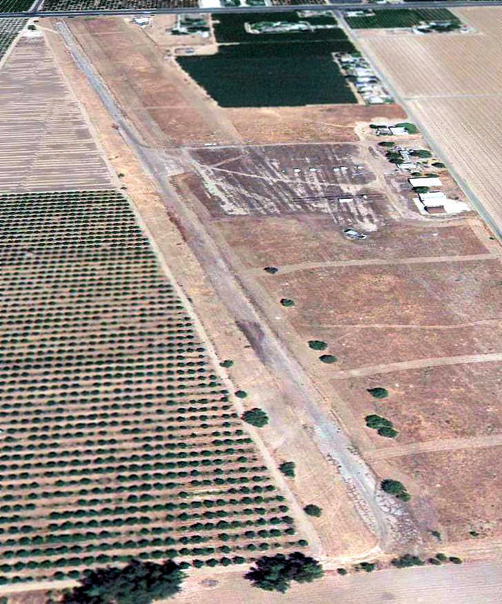
A 1984 aerial view depicted the Synanon Airfield as a 3,700' paved northeast/southwest runway, along a slightly different alignment than the clearing depicted in the 1957 aerial photo.
One closed-runway “X” symbol was on the north end of the runway, which had many vehicles or other objected stored along it.
Several buildings were on the west side, but there were no aircraft or other signs of recent aviation use.
The last aeronautical chart depiction which is available of Synanon Airport was on the 1983 CA Aeronautical Chart (courtesy of Jonathan Westerling).
It depicted Synanon as an unlabeled private airfield.
Jonathan Westerling reported, “The Synanon Airfield was last listed in the 1989 Western States Flight Guide, described as having a 4,500' runway but adding a notation that the facility might be closed due to construction on the field.”
The last aeronautical chart depiction which has been located of Synanon Airfield was on the April 1989 San Francisco Sectional Chart.
A 1993 aerial view looking northwest depicted Synanon as having a single north/south runway, which had been cleared of the objects seen stored on the runway in the 1984 photo, but the pavement was no longer distinct.
A second large building had been added along the southwest side at some point between 1979-93.
Synanon Airfield was evidently closed at some point between 1989-93,
as it was no longer depicted on the October 1993 San Francisco Sectional Chart (courtesy of Ron Plante),
which instead only depicted “Buildings” at the airfield site.
No airfield was depicted at this location on the 2012 USGS topo map.
Jonathan Westerling reported, “A Sierra Club hiker visited the airfield in 2015 & noted their observations a local newsletter:
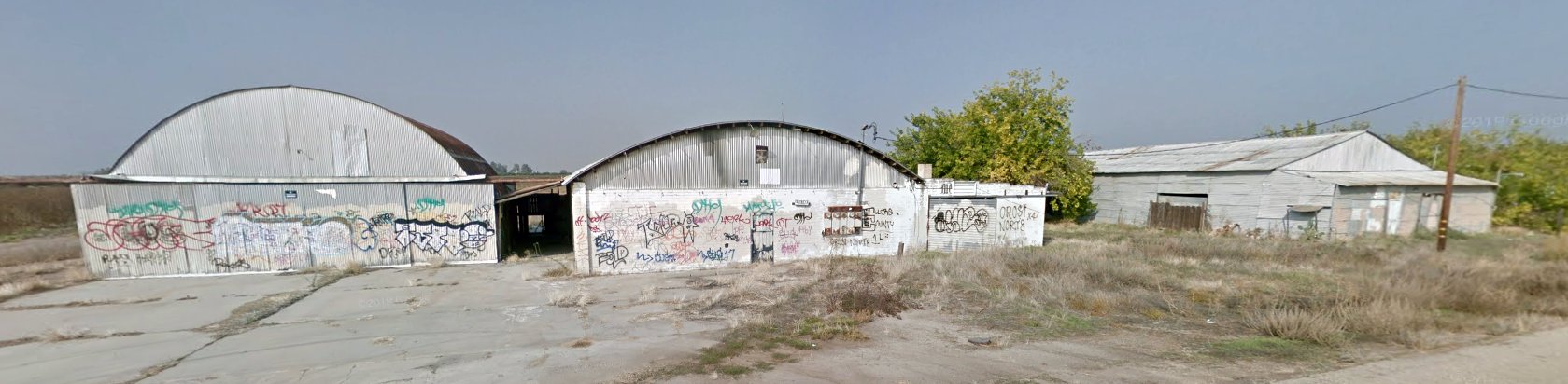
'Next to an abandoned runway... is a large airplane hangar.
The property was subsequently re-purposed as [Baladullah], a Muslim religious community & boarding school but was abandoned... amid accusations of fraud.'"
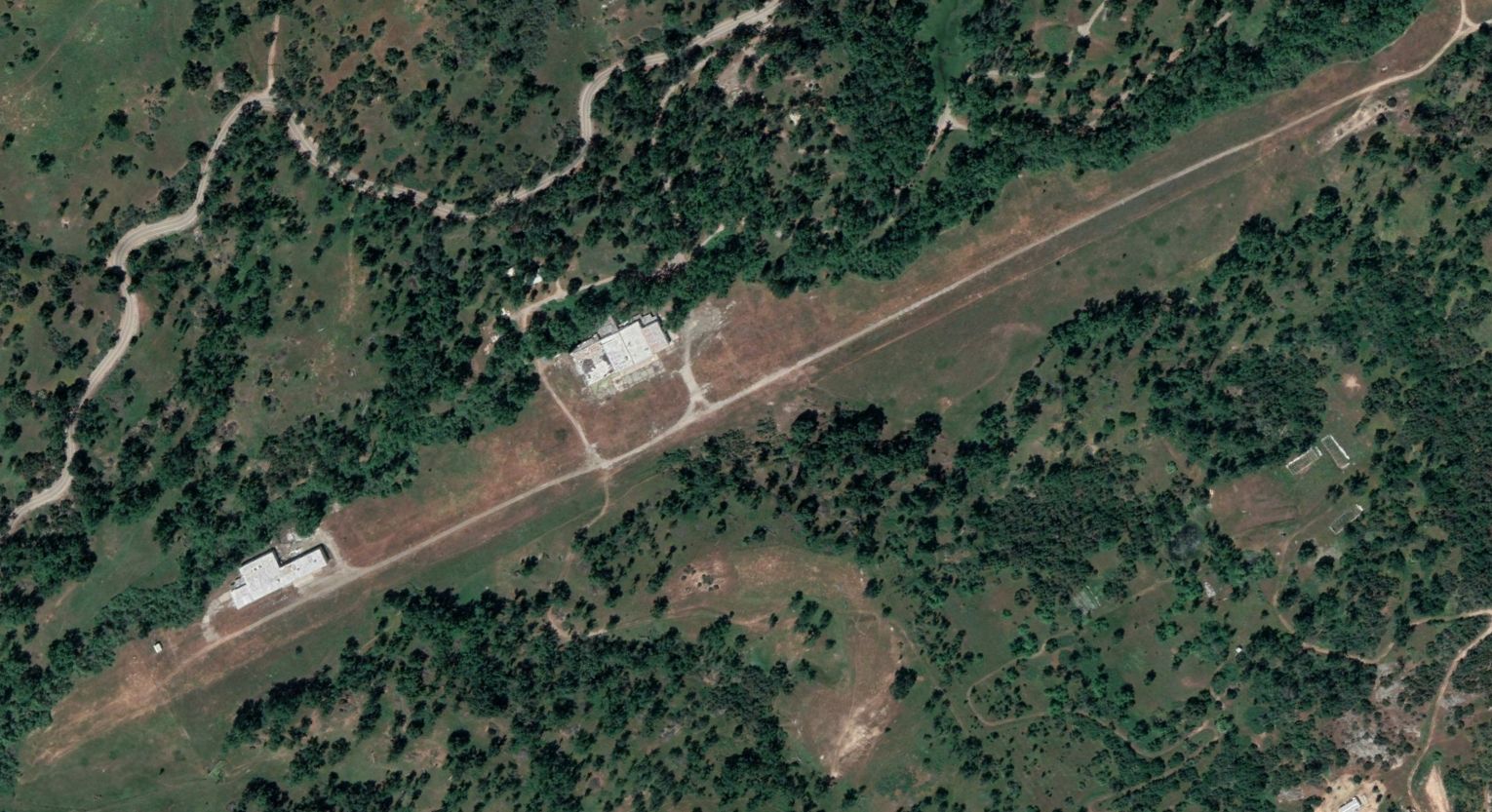
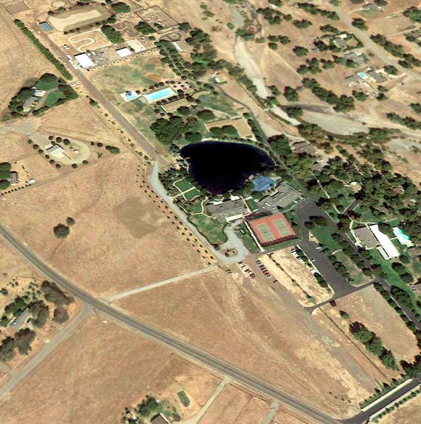
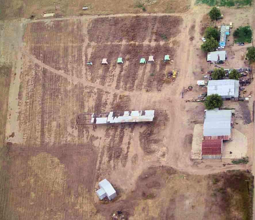
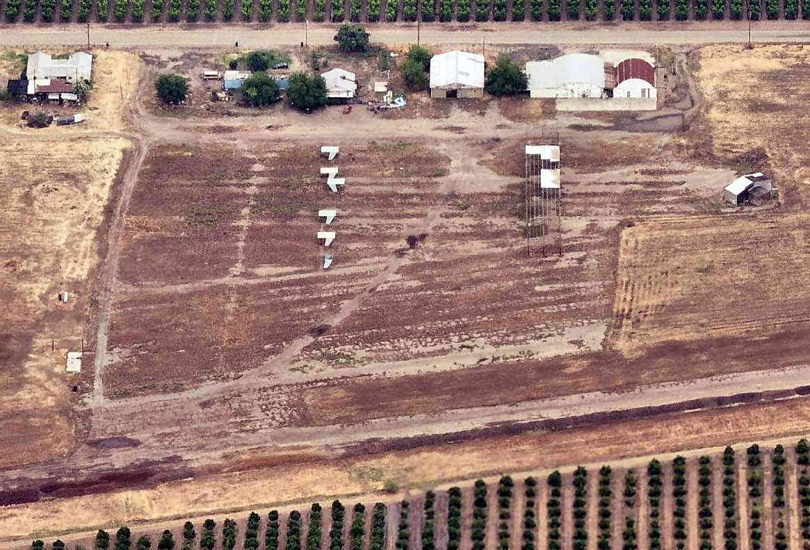
A 2020 aerial view looking northwest showed the Synanon hangars remained standing, but the runway pavement was gone.
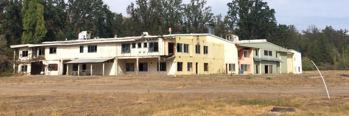
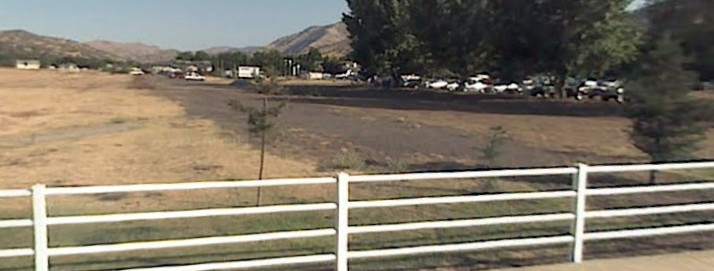
A 2024 or earlier photo of the former Synanon hangar, offered as a rentable corporate retreat center - albeit without a landing area.
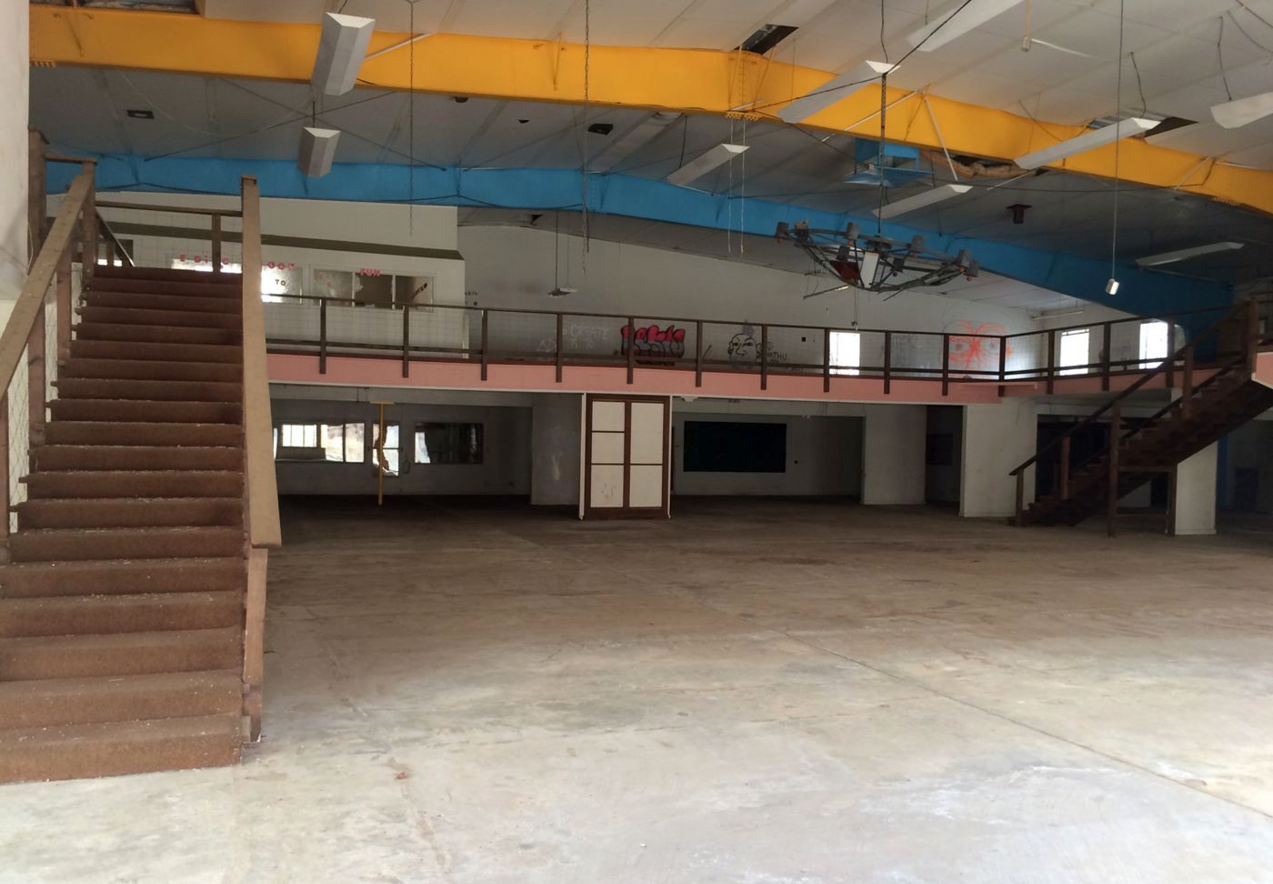
A 2024 or earlier photo of the interior of the former Synanon hangar.
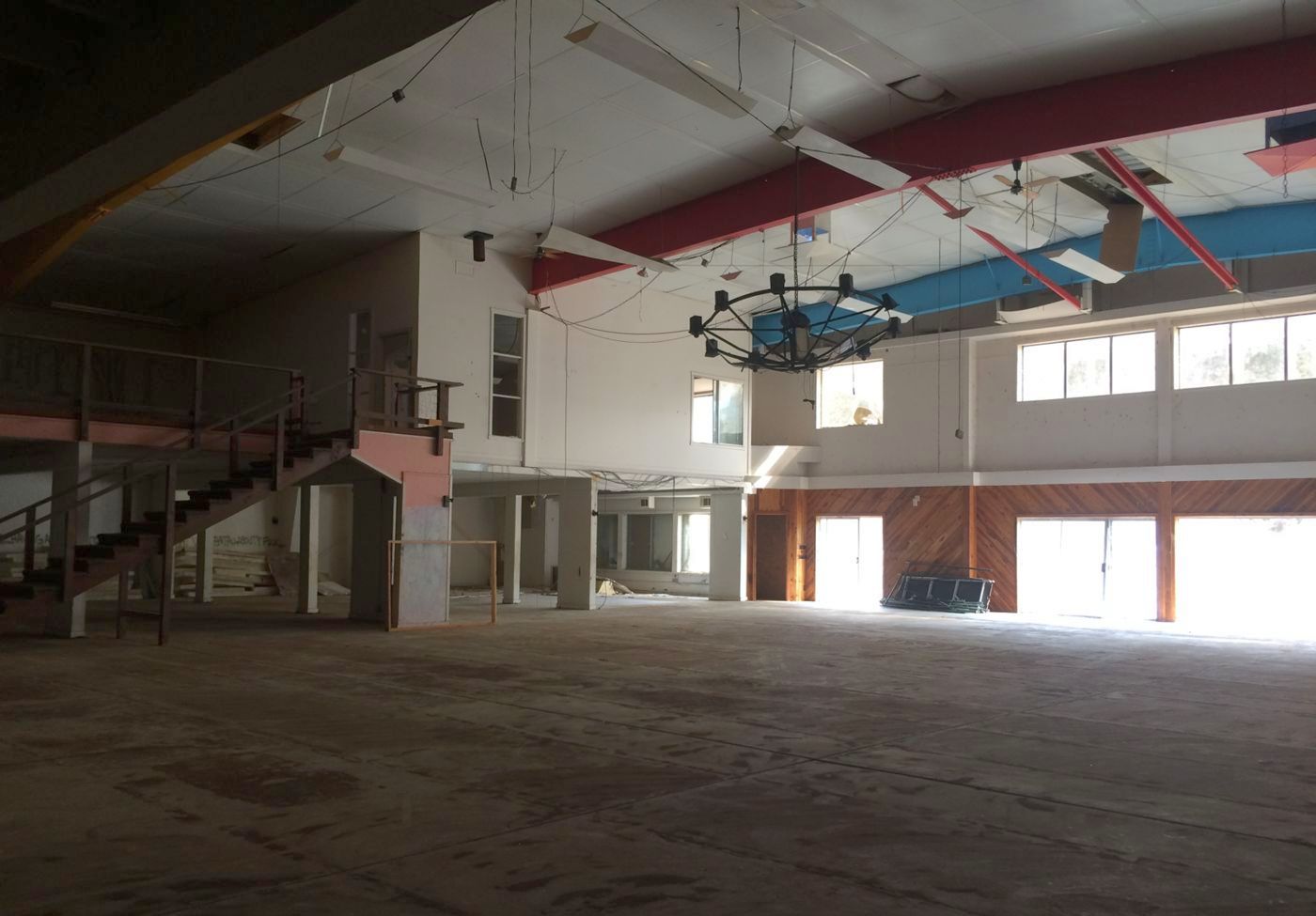
A 2024 or earlier photo of the interior of the former Synanon hangar.
____________________________________________________
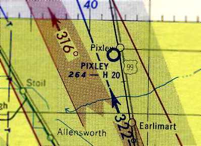
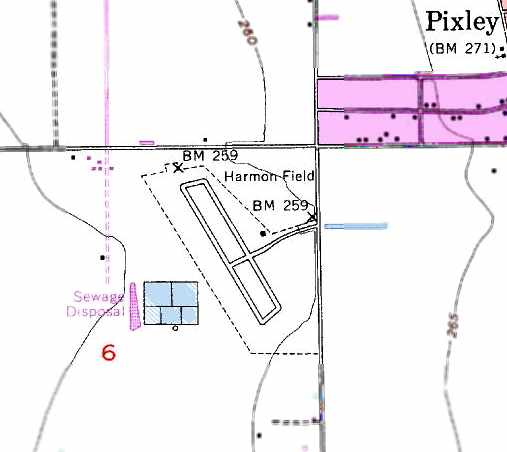
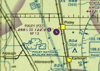
Pixley Airport / Harmon Field, Pixley, CA
35.96, -119.31 (Southeast of Fresno, CA)
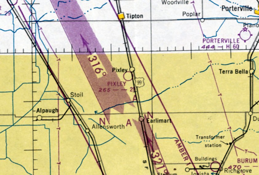
Pixley Airport, as depicted on the September 1950 LA Sectional Chart.
Pixley Airport was not yet depicted on the February 1949 LA Sectional Aeronautical Chart (according to Chris Kennedy)
nor on the September 1949 Mt. Whitney World Aeronautical Chart.
Pixley Airport's 2007 FAA Airport/Facility Directory data lists an “Activation date: 2/1949”.
Pixley Airport was not yet depicted on the 1950 USGS topo map.
The earliest depiction which has been located of Pixley Airport was on the September 1950 LA Sectional Chart.
It depicted Pixel as having a 2,900' unpaved runway.
According to a CA State report, Harmon Field was used as a base for crop duster activity starting in 1951.
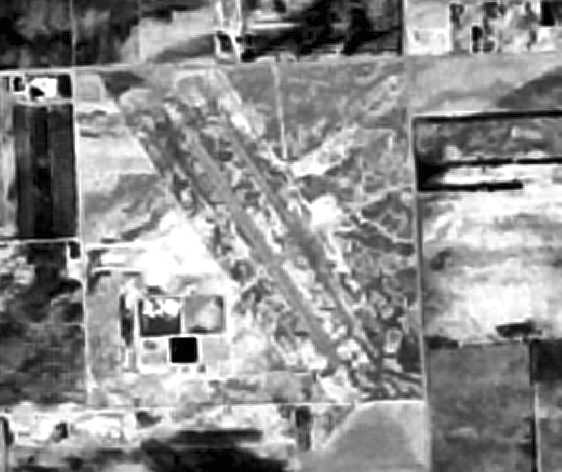
The earliest photo of Pixley Airport which has been located was a 7/11/54 USGS aerial photo.
It depicted the field as having a paved northwest/southeast runway & a paved parallel taxiway.
The September 1954 LA Sectional Aeronautical Chart (courtesy of Chris Kennedy)
depicted Pixley Airport as having a 2,000' hard-surface runway.
According to Jereme Brogan, “My Grandfather Louie Williams operated Pixley Dusters from Harmon for many years,
he also leased the north end of the airport to Earlimart Dusters.
My grandfather opened for business in the 1950s.”
The 1955 USGS topo map depicted Harmon Field as having a paved northwest/southeast runway with a parallel taxiway.
The town had renamed its airport after resident Roy Harmon, who was posthumously awarded the Medal of Honor for WW2 actions.
A 7/14/69 USGS aerial view depicted Harmon Field as having a paved northwest/southeast runway & a paved parallel taxiway.
A hangar & ramp were located on the east side, on which was parked possibly 1 light aircraft.
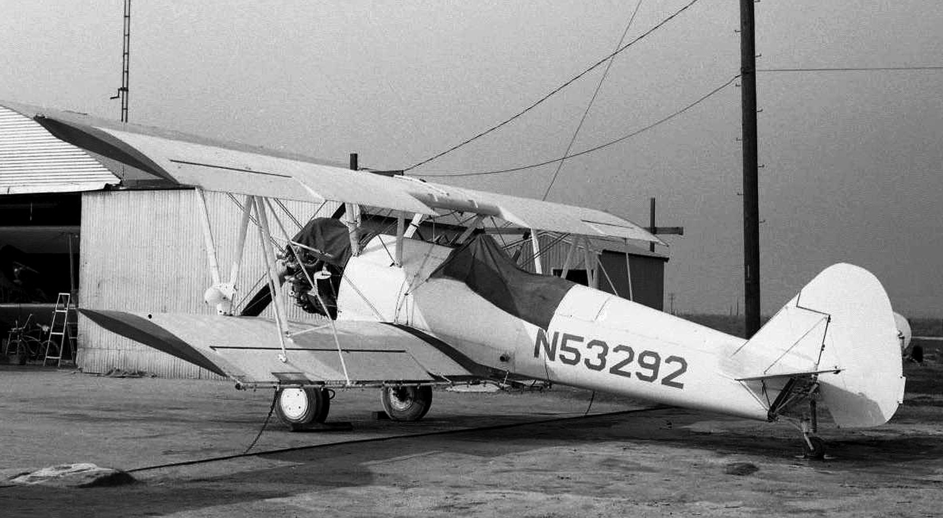
The only photo which has been located of an aircraft at Pixley Airport was a February 1971 photo by Jay Sherlock of Meeks Dusters Stearman PT-27 N53292 (ex 42-15667) in front of a hangar; one of 4 Stearmans Jay saw at Pixley that day.
The July 1989 LA Sectional Aeronautical Chart (courtesy of Chris Kennedy)
continued to depict Pixley as an active public-use airport with a 2,000' hard-surface runway.
According to the California Pilots Association, Pixley Airport was closed in 1989.
The 1991 USGS topo map depicted Harmon Field as having a paved northwest/southeast runway, along with a parallel taxiway,
and a single building on the east side of the field.
According to Jereme Brogan, “The airport was closed in 1992-93.
At the time Harmon was closed [it] ran 5 planes 7 days a week.
It was in fact closed by the EPA & either is a superfund site or was considered for it due to the contamination from 40 years worth of chemicals.”
According to a CA State report, Harmon Field was used as a base for crop duster activity until 1994, when the airport was closed.
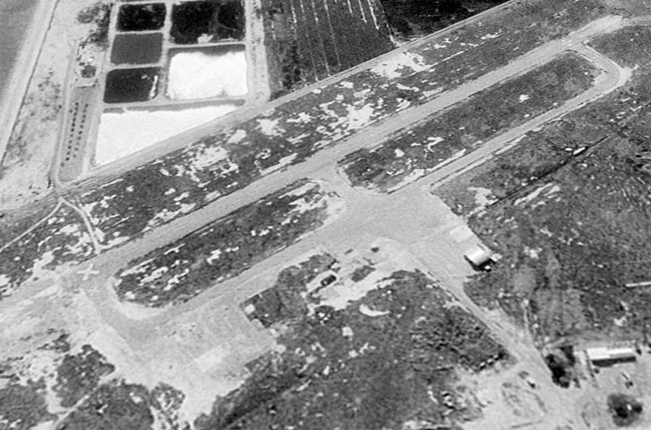
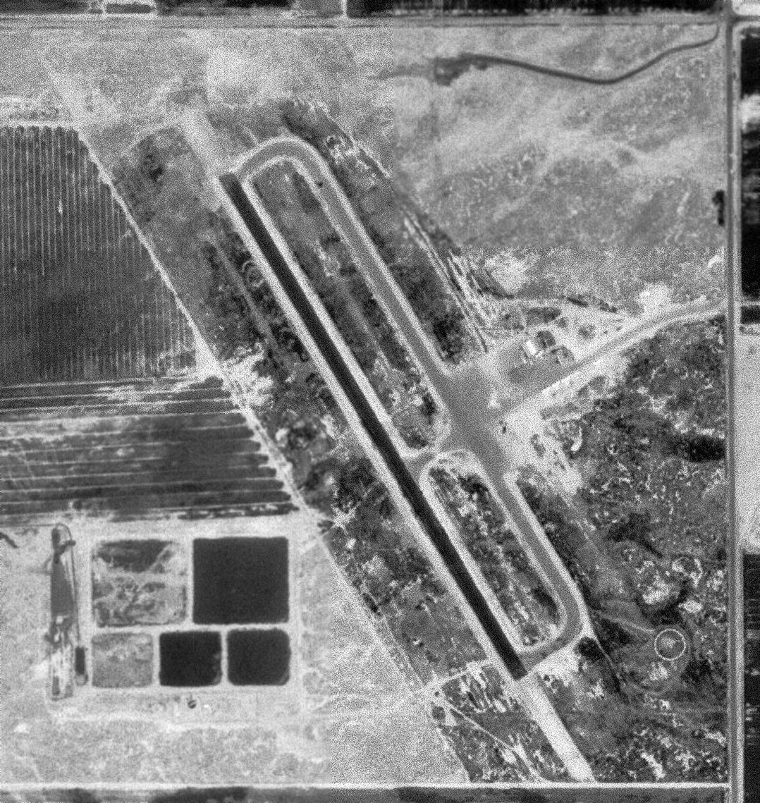
A 1994 USGS aerial view looking west showed Harmon Field as abandoned, with a closed-runway “X” symbol visible on the southern end of the runway.
The paved runway, taxiways, and ramps remaining intact. A single arched-roof hangar appeared to remain on the east side of the field..
Strangely, Pixley Airport remained depicted on the 2007 Sectional Chart as an active public-use airport, with a single 2,000' paved runway.
Inexplicably, Pixley Airport remained listed in the FAA's Airport/Facility Directory in 2007 as an active-public use airport, although with the remark “Airport closed indefinitely”
(even though other information indicates it has been closed for 18 years).
It was described as having a single 2,050' asphalt Runway 13/31, “in fair condition.”
The field was said to be owned by Tulare County, with the manager being Steven Larson.
Pixley Airport was said to have 7 aircraft based on the field, including 1 multi-engine aircraft,
and was said to conduct an average of 23 takeoffs or landings per day.
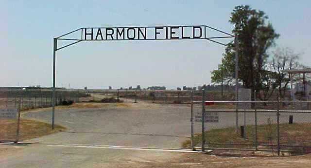
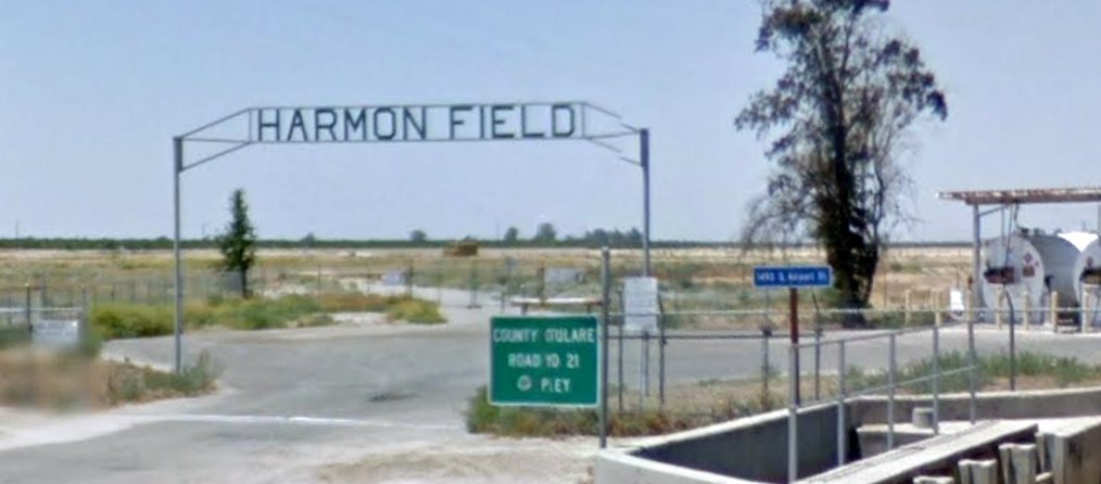
A 2007 photo by Charles Irvin of the sign for Harmon Field.
Charles reported, “The field is still there, but story has it that a crop duster service operated out of there for many years,
and they were dumping their chemicals onto/into the ground there,
so while the runway is still intact, the field is off limits because of the levels of toxicity.”
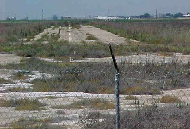
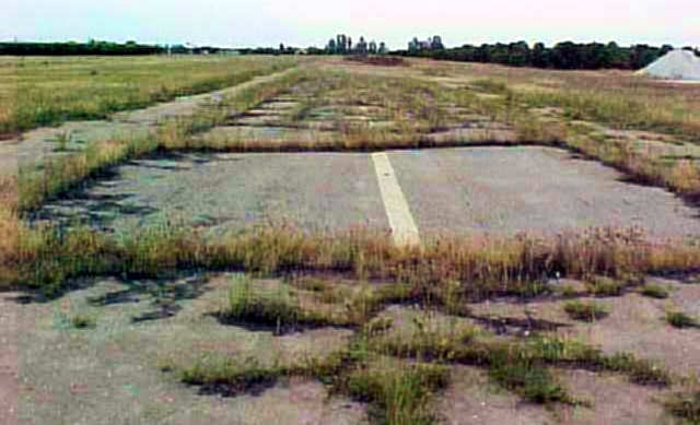
A 2007 photo by Charles Irvin of the remains of the runway at Harmon Field.
Charles reported, “Ironically, the runway is still marked,
though the numbers aren't clear & there are no X's on it,
but you can tell that no aviation activity has been going on there for a very long time.
There are berms around the borders of the place & I think an irrigation ditch on the east border,
so it can't be seen too well from the streets that surround it.
The hangar is gone! It was demolished by Tulare County as part of the hazardous material cleanup of the site.
Upon seeing this, I'd assume that the runway/taxiway are next.
The street that runs along the east border (where the entrance is), is appropriately called Airport Road.”
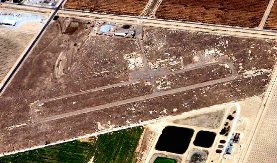
A 10/1/09 aerial view by Del Kienholz looking northeast at the remains of the runway at Harmon Field.
A circa 2010 aerial view looking north shows the foundations of several hangars at the site of Harmon Field.
Mike Huerta reported in 2013, “I believe there is a plaque out there [indicating that Harmon Field was named in honor of Roy Harmon]
unless someone stole it for scrap metal.”
A 2015 photo looking west at the Harmon Field sign.
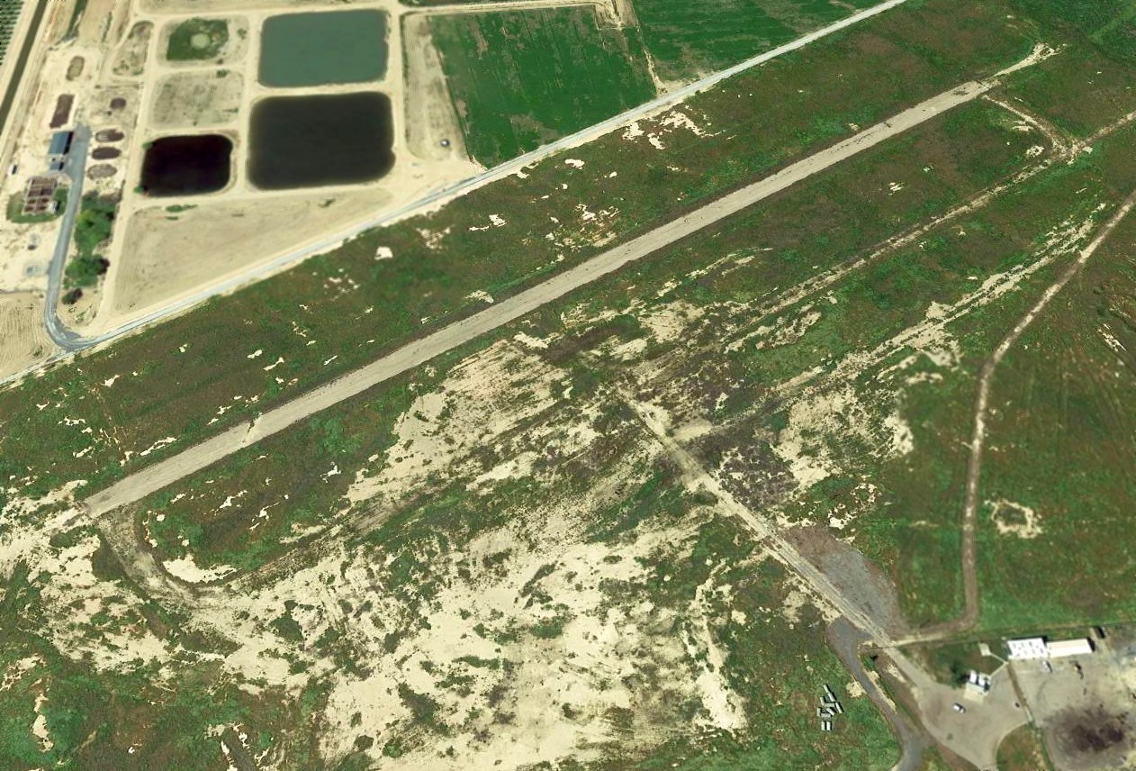
A 2017 aerial view looking west showed Harmon Field's runway remains intact though deteriorated.
Jaime Rox reported in 2018, “I'm going to find out if it is possible to clean up the land & replenish the soil in hopes of bringing aircraft back
and restore the memorial that apparently had been moved to a museum due to vandalism.”
Harmon Field was no longer depicted on the 2016 LA Sectional Chart.
____________________________________________________
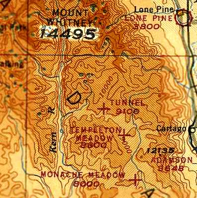
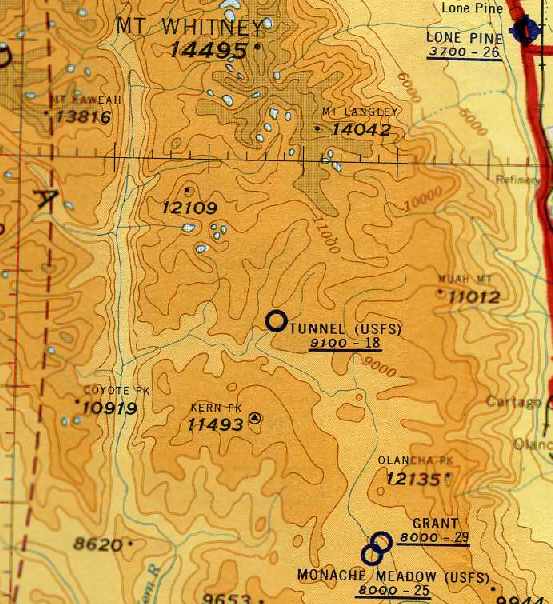
Tunnel Meadows Airport, Tunnel Meadows, CA
36.38, -118.26 (Southeast of Fresno, CA)
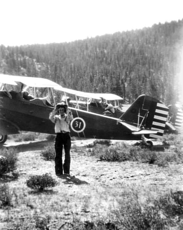
A 1931 photo of Leona Shellenbarger in front of 2 Army Air Corps biplanes
which brought Col. “Hap” Arnold from March Field to Tunnel Meadows.
This extremely high-elevation backcountry strip
was located just south of Mt. Whitney, the highest point in the 48 United States.
According to Pat Decano, “The airfield was created by my uncle, Leonard Shellenbarger,
at the request of a Dr. Shook in 1931.
Dr. Shook was a friend of Bert Johnson, a cattleman, and he wanted to fly in so he could fish there.
He drug the field with a Fresno scraper pulled by a mule & was paid $40 by Dr. Shook for the job.
The Fresno scraper was packed in on a mule.
In 1931, then Col. 'Hap' Arnold & a buddy flew in from March Air Force Base to fish.
When they were ready to leave in the afternoon, my grandfather said that they could not make it out.
Arnold's plane crashed & my son has the cigar-sized box that was made from scraps of the plane.
It is olive drab painted aluminum.
My grandfather, Everett Shellenbarger, was the ranger there at the time.”
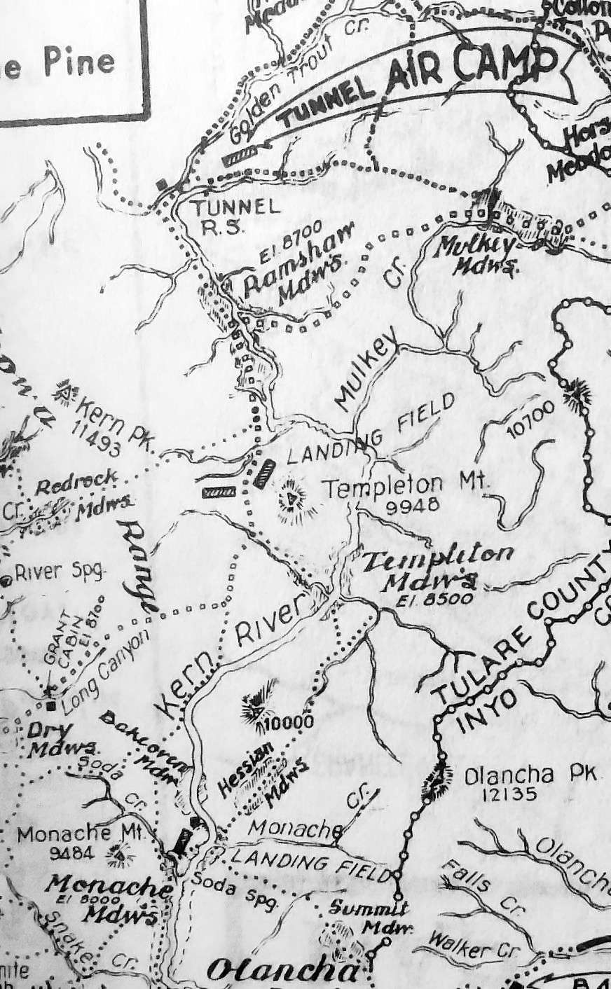
The earliest map depiction which has been located of the Tunnel Meadows Airport was on a 1939 Tulare County road map (courtesy of Kevin Walsh).
It depicted “Tunnel Air Camp” as having a southwest/northeast runway.
An undated (circa 1930s-40s?) photo of Grace Morgan alongside of Bob White's Travel Air biplane (2000 or 4000) at Tunnel Meadows.
However, the Tunnel Meadows airfield was not yet depicted on the August 1944 Mt. Whitney Sectional Chart
nor listed among active airfields in the 1945 AAF Airfield Directory (courtesy of Scott Murdock).
The earliest aeronautical chart depiction of the Tunnel Meadows Airport which has been located
was on the August 1945 Mt. Whitney World Aeronautical Chart (courtesy of Chris Kennedy).
It depicted Tunnel Meadows as an auxiliary airfield, at an elevation of 9,100'.
The September 1949 Mt. Whitney World Aeronautical Chart
depicted “Tunnel” as having a 2,100' unpaved runway.
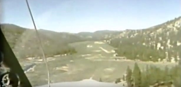
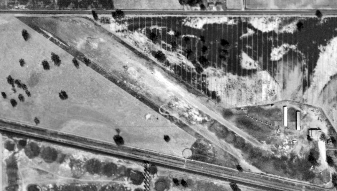
The earliest aerial photo which has been located of Tunnel Meadows was a 7/3/54 aerial view (courtesy of Dallam Oliver-Lee),
showing a single unpaved northeast/southwest runway.
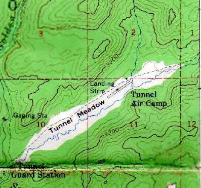
The 1955 USGS topo map (courtesy of Ted Sarbin) depicted the “Tunnel Air Camp” as having a single runway.
The last aeronautical chart depiction which has been located of the Tunnel Meadows Airport
was on the May 1957 Mt. Whitney Sectional Chart (courtesy of Chris Kennedy).
It depicted “Tunnel (USFS)” as having only an 1,800' unpaved runway.
Tunnel Meadows Airport was evidently no longer charted at some point between 1957-59,
as it was no longer depicted on the March 1959 Mt. Whitney Sectional Chart (according to Chris Kennedy).
A still image of Tunnel Meadows Airfield from the 1966 FAA movie, “Density Altitude with Harry Bliss” (courtesy of Graeme Smith).
Ted Sarbin recalled, “The FAA made a movie on mountain flying.
In it, a pilot in a Bonanza tries to land at Tunnel Meadows but changes his mind when he sees the field so he lands at Lone Pine.
There he encounters a cheerful, friendly older flight instructor
who gives him some mountain flying dual instruction & then he lands at Tunnel Meadows.
I've seen the film & it is well done; both interesting & instructive.
The problem was that pilots would see the film & then show up at Lone Pine expecting to find that instructor.
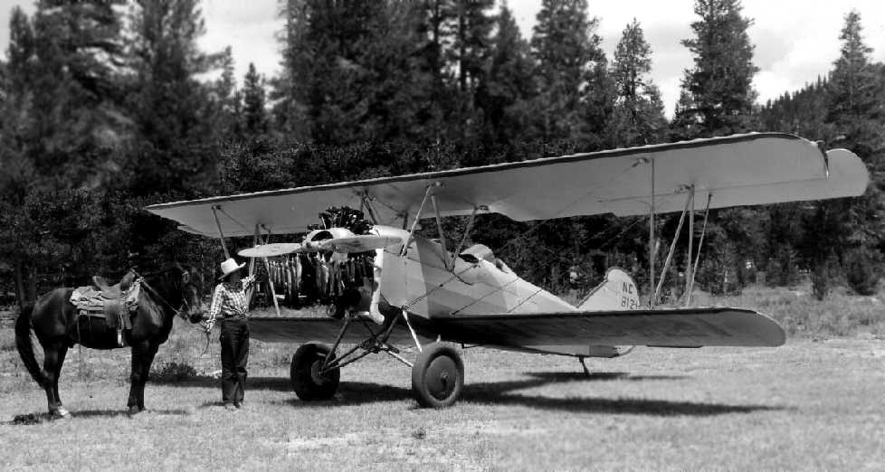
Of course, the instructor was an actor & the real airport manager, Bob White,
was in the business of flying people in & out of Tunnel Meadows
and not especially interested in helping pilots to fly in & out themselves.”
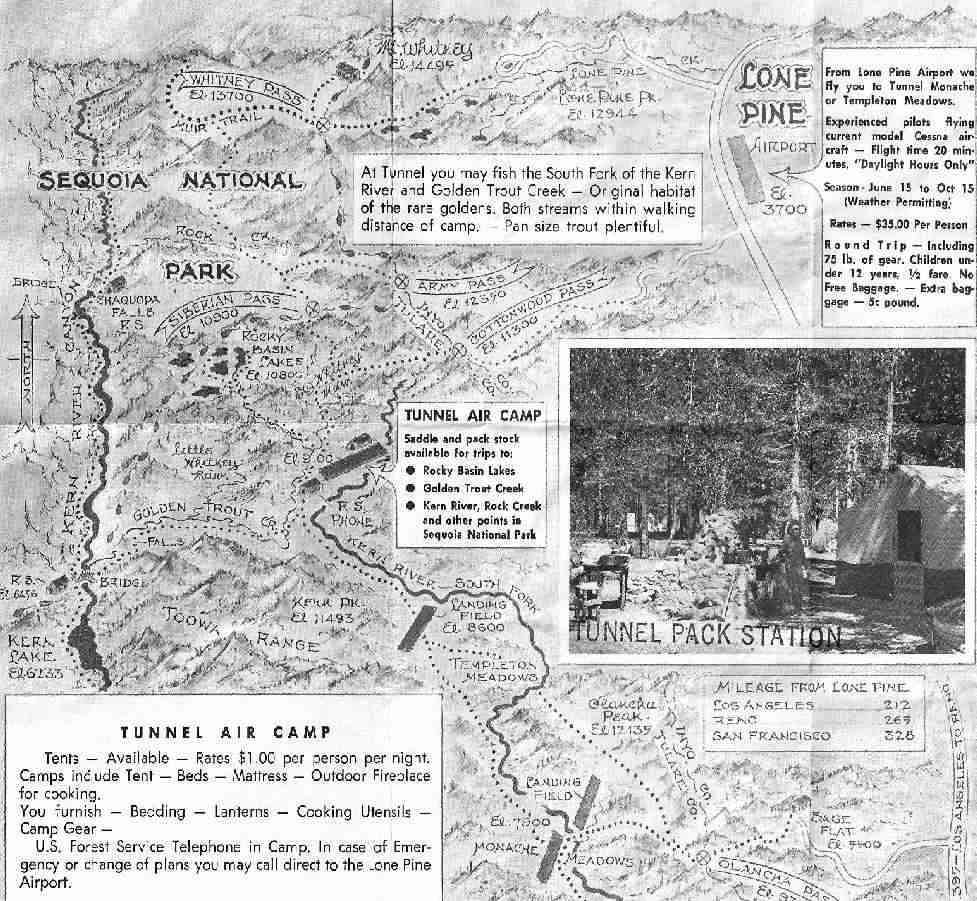
A 1970 map depicting the “Tunnel Air Camp” from a brochure for the Bob White Flying Service (courtesy of Jeff Yohe).
Jeff recalled, “At Tunnel Meadows I only remember a ranger station to the west, a small equipment shed & a few tents at the east end of the field.
We did some hikes from the Circel B Scout Ranch (Kennedy Meadows) to the south through Tunnel Meadows then north over the back side of Whitney.
We'd have Bob fly our food in for the second half of our trip. Bob was always on time with a smile on his face.”
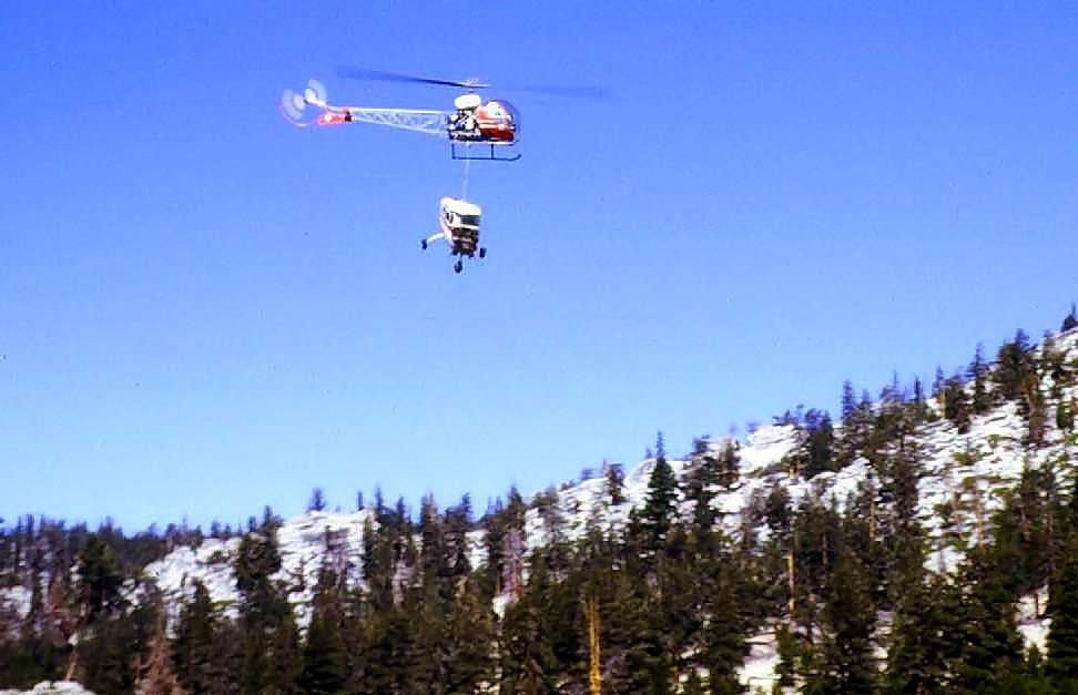
A 1971 photo by Jeff Yohe of a Bell 47 helicopter removing the wreckage of what appears to be a Cessna from Tunnel Meadows.
Jeff recalled, “We were hiking through there & saw the helicopter removing some wreckage.”
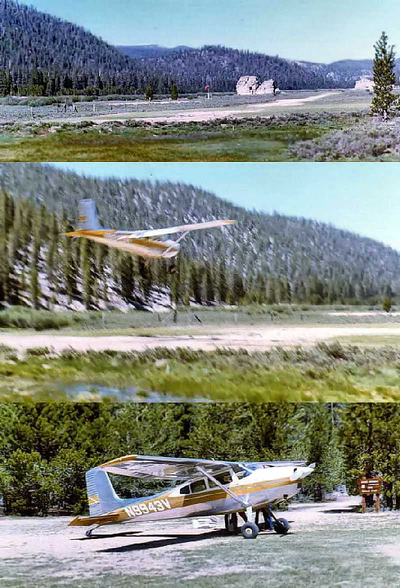
A series of photos by Ted Sarbin of a Cessna 180 landing at Tunnel Meadows in 1972.
Ted Sarbin recalled, “It was around 1,800' long.
I flew in there twice, both times as a passenger of Bob White's flying service.
I had flown to Lone Pine but I didn't have the skill or a suitable plane for Tunnel Meadows.
There were a number of accidents there.
There was a single-wire (the other half of the circuit was ground) party line Forest Service magneto-crank phone.
Cranking long-short-short would get Bob White to answer in Lone Pine & come & pick us up.
If one were landing to the west, a go around was possible, the other direction was marginal.”
Ted continued, “When it was operating, Bob White had guides, pack horses for rent,
and tents, tables & refrigerators (no electricity, they were used as ice boxes).
Also, there was a tractor for moving planes & taking the passengers' gear to their campsite.”
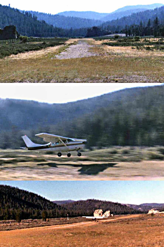
A series of photos by Ted Sarbin of a Cessna 206 landing at Tunnel Meadows in 1985.
According to Ted Sarbin, “The airport was closed when the Wilderness areas was established.”
Simon Hickey reported in 2009, “ I'm a flight instructor with the UK Royal Air Force & I can confirm that Tunnel Meadows,
at the height of summer can be quite challenging for the less-experienced guys. Especially in a C-130.
Done it several times [made a low approach]. We regularly exercise at China Lake & Inyokern training up crews prior to their going to Afghanistan.
There are a few high altitude airstrips in Afghanistan so somewhere like Tunnel Meadows gives crews exposure to the reduced performance.
Doing in on night vision goggles was 'interesting'”
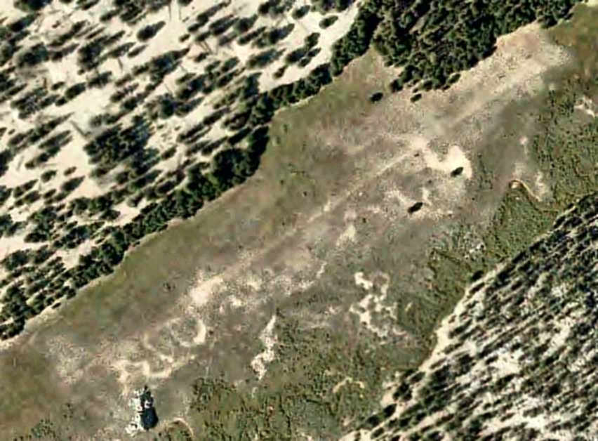
A 4/24/10 aerial photo (courtesy of Dallam Oliver-Lee) showed the outline of Tunnel Meadows' runway to still remain recognizable.
A 2012 photo of Tunnel Meadows Airfield.
A 4/20/13 aerial view looking west showed the orientation of Tunnel Meadows' runway to still remain recognizable.
____________________________________________________
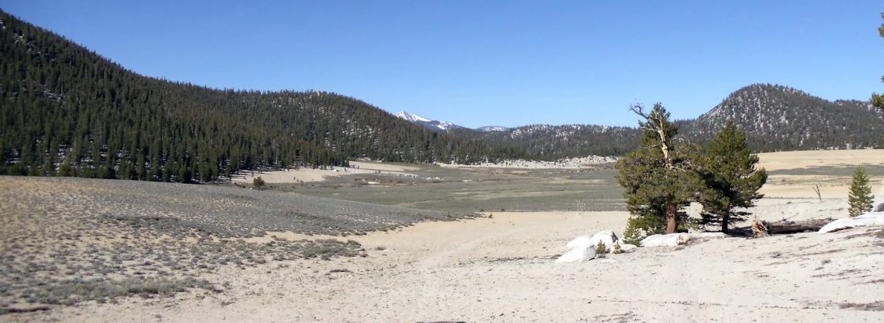
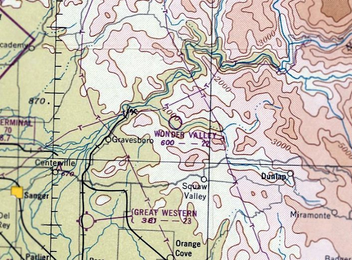
Wonder Valley Airport, Squaw Valley, CA
36.8, -119.31 (East of Fresno, CA)
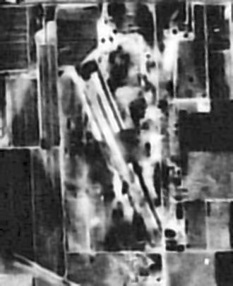
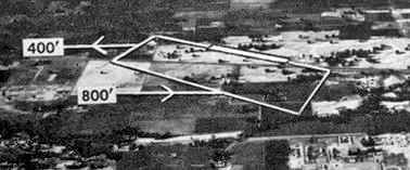
Wonder Valley Airport, as depicted on the September 1949 Mt. Whitney Sectional Chart.
Photo of the airport while open has not been located.
This small airport was evidently established at some point in 1949,
as it was not yet depicted on the February 1949 Mt. Whitney Sectional Chart.
The earliest depiction of Wonder Valley Airport which has been located was on the September 1949 Mt. Whitney Sectional Chart.
It depicted Wonder Valley as having a 2,200' unpaved runway.
The earliest photo which has been located of Wonder Valley Airport was a 1957 aerial view.
It depicted Wonder Valley as having a northwest/southeast unpaved runway, with a few small buildings on the east side.
A 1963 aerial view depicted Wonder Valley in an unchanged fashion.
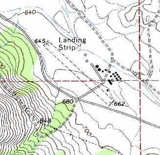
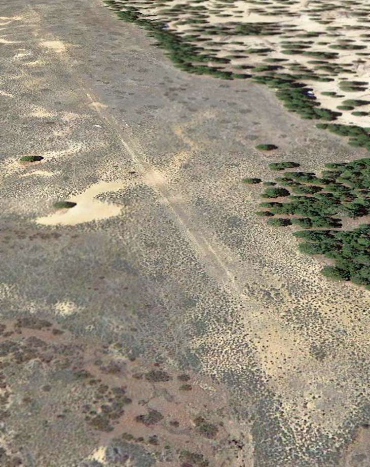
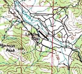
The 1965 USGS topo map depicted Wonder Valley Airport as a single unpaved runway, labeled simply as “Landing Strip”,
with a complex of buildings to the east.
The January 1967 Mt. Whitney Sectional Chart (according to Chris Kennedy) still depicted Wonder Valley as having an unpaved runway.
Wonder Valley apparently gained a paved runway at some point between 1967-72,
as the 1972 Flight Guide (according to Chris Kennedy) depicted Wonder Valley as having a 2,310' paved runway.
According to Jonathan Westerling, “Apparently FedEx used to land there when Fresno was socked in.”
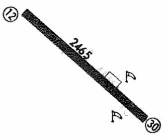
The 1974 Flight Guide (courtesy of Jonathan Westerling) depicted Wonder Valley Airport as having a single 2,465' paved Runway 12/30, with a ramp on the east side.
The field was noted to conduct glider operations.
The 1977 Sectional Chart (courtesy of Jonathan Westerling) depicted Wonder Valley Airport as having a single 2,300' paved runway.
The 1979 USGS topo map still depicted a single runway, but it was labeled merely as “Landing Strip”,
which typically indicated that the airport was closed by that point.
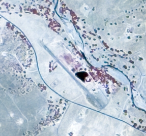
A 1984 aerial view showed Wonder Valley as having an asphalt runway,
with an amazing assemblage of over 2-dozen light single-engine aircraft.
Wonder Valley Airport, as depicted on a 1987 aerial view.
The last aeronautical chart depiction which has been located of Wonder Valley Airport
was on the April 1989 San Francisco Sectional Chart (courtesy of Jonathan Westerling).
It depicted Wonder Valley Airport as having a single 2,300' paved runway.
The last photo which has been located showing aircraft at Wonder Valley Airport was a 5/28/93 USGS aerial view looking north.
Two single-engine aircraft were visible at the bottom-right.
Wonder Valley Airport was evidently closed at some point in 1993,
as it was no longer depicted on the October 1993 San Francisco Sectional Chart (courtesy of Ron Plante).
An 8/16/98 USGS aerial photo showed the Wonder Valley runway had been painted with closed-runway “X” symbols.
Otherwise, the field remained completely intact.
Ben Siebert recalled, “Wonder Valley - Last time I flew in there was 1998 in a Turbo Arrow.
We were practicing some take offs & landings, and on the 3rd one someone came up to us & told us the airport was private.
When I was flying checks for Western Aero that we used Wonder Valley as a backup if FAT was below minimums, though if FAT was usually Wonder Valley was too.
You could always tell when FAT went above minimums, because all of a sudden you'd have a King Air, a couple of Cessnas, a couple of Grummans,
and who knows what all taking off within a few minutes out of Wonder Valley.”
A 12/31/04 aerial photo showed the Wonder Valley runway remained intact.
Jonathan Westerling reported in 2005, “The place is now a summer camp / retreat center.”
A 2007 photo looking northwest along the remains of the Wonder Valley asphalt runway.
A 5/24/09 aerial photo showed the midpoint of the Wonder Valley runway had been covered with lawns & a building.
An 8/27/12 aerial view looking north shows the majority of the Wonder Valley runway remained intact, and the “R” private runway designation was still visible at the bottom-right.
The site of Wonder Valley Airport is located north of the intersection of Palomino Drive & Elwood Road.
Thanks to Jonathan Westerling for pointing out this field.
____________________________________________________
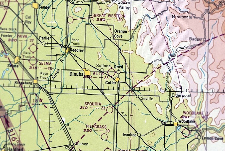
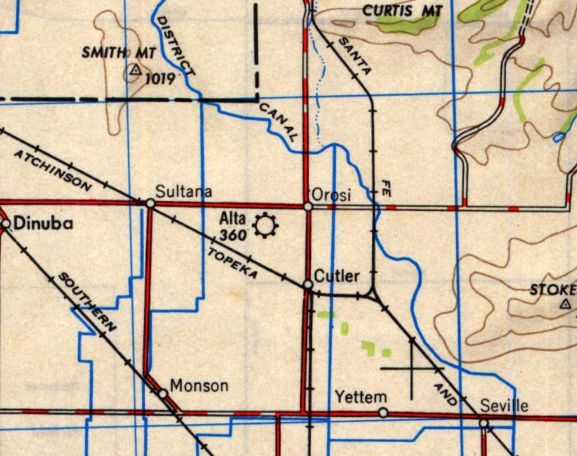
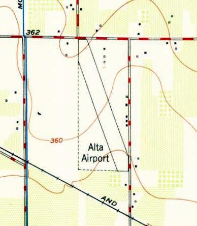
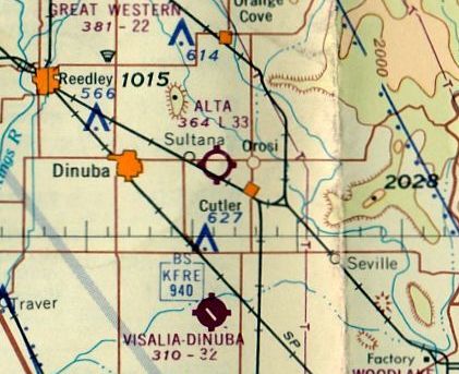
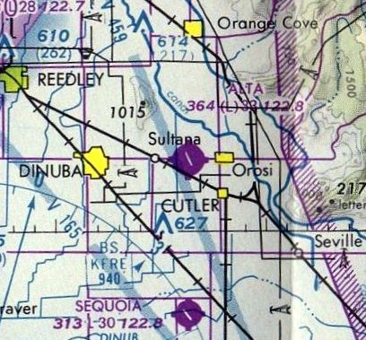
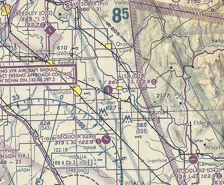
Alta Airport (O10), Dinuba, CA
36.54, -119.32 (Southeast of Fresno, CA)
A 1946 aerial view of the Alta Airport (from the Alexandria Digital Library, courtesy of Chris Kennedy).
The date of construction of this little general aviation airport is unknown.
The earliest reference to Alta Airfield comes from Tom Jackson,
who recalled, “In 1943-44, my parents & I stayed with one of my mother’s brothers, George (Goldie) Kliewer, who was involved in the operation of Alta Airport.
His partner was a Mr. Blair. We were there at least as early as 1944 & the field had been in operation for some time prior to that, according to my mother.
I don't recall any military use of the field when I was there.
A cousin, Budd Kliewer, later operator of Budd Aero, was also based there at the time.”
However, no airfield at this location was listed among active airfields in the 1944 US Army/Navy Directory of Airfields (courtesy of Ken Mercer)
or the 1945 AAF Airfield Directory (courtesy of Scott Murdock),
or depicted on the August 1946 Mt. Whitney Sectional Chart.
The earliest depiction of Alta Airport which has been located
was a 1946 aerial view (from the Alexandria Digital Library, courtesy of Chris Kennedy).
It depicted the field as having a single northwest/southeast runway with a parallel taxiway.
The earliest aeronautical chart depiction which has been located of Alta Airport was on the February 1947 Mt Whitney Sectional Chart.
It depicted Alta as having a 2,300' unpaved runway.
The earliest topo map depiction which has been located of Alta Airport was on the 1948 USGS topo map.
It depicted Alta as a commercial/municipal airport.
Lloyd Johnson recalled, “The hangars where the dusters & the [Cessna] 195 were parked was like a carport: a roof & no walls.
I don't remember any military at Alta during the war.
After the war my brother, Floyd Johnson, received his private license at Alta. Bud was his instructor. He never flew after that.
The first time I flew from the field was 1948-49.
A friend Gene Duerksen owned a Cessna 180. Later years I flew prisoners in it when needed.”
The earliest aeronautical chart depiction which has been located of Alta Airport
was on the 1949 Mt Whitney Sectional Chart (according to Chris Kennedy).
It described Alta as having a 2,300' unpaved runway.
The 1950 USGS topo map depicted Alta Airport as having a single northwest/southeast runway,
with 3 small buildings on the north side & 5 small buildings on the east side.
Susie O'Brien recalled, “I was born 1/10/53 in Fresno.
When I was taken home from the hospital, I was flown in a Cessna 195, which landed at the Alta Airport... my home.
I lived on the airport from January 1953 until I was 8 years old. It was a truly amazing childhood.
At that time there were many private airplanes tied down there, in addition to my father's & Godfather's cropdusting business
and an aircraft repair shop with a full-time mechanic, John Rawson, as well. It was a very busy place back then.
There was a house there, and an office, and a clubhouse, and 2 large hangars.
There is also a long strip of a now decaying hangars, under which my father, Stan O'Brien, parked his 2 Stearman crop dusters.
He & my Godfather, Bud Kliewer, owned & operated Bud Aero Inc as partners from approximately 1950-62 or 63.
Stan retired from crop dusting & went into charter piloting & law enforcement for a short time.”
Lloyd Johnson recalled, “I came back to Dinuba in December 1954.
Bud or Stan called me stating they were starting a new company which would be for transporting prisoners for counties under contract & needed someone to ride shotgun.
I did that a couple of times & said to them if I'm going to ride in the plane I'm going to fly it.
I received my Private & Commercial [pilot's] license at the airport in Visalia.
I flew the Cessna 195 mostly, also 180s, 170s,172s and any thing else that was available.
The 195 was the plane that Stan's daughter talks about & my favorite.”
Lloyd continued, “Once as I was about to leave on a flight, Bud was taking off with a load of Systok.
I heard a change in the sound of the engine. I looked to the North end of the field - no plane.
I ran to the pickup, Bud's loader jumped on the running board & we headed for the end of the runway.
Bud & plane was upside down, across the road, in a vineyard. He was hanging from his harness soaked in the chemical.
John Rawson (mechanic) arrived about the same time; we cut Bud out of his harness & lowered him to the ground.
Very happy he got over the power lines. Lesson learned - Bud wore a hard helmet & when he crashed a large gash was put in the helmet, which saved his life.
Stan liked his 'Smiling Jack' leather helmet with goggles. After the crash he got himself a hard helmet.”
Lloyd continued, “I left early one morning & returned late. The next day when I arrived I saw that the hangars had been painted.
I asked BJ who had done it. She said some painters had come by & gave them a good deal.
I told Bud and Stan that the Williams family was out & about. They didn't know what I was talking about.
A couple of days later they did when it rained all the paint washed off.”
Lloyd continued, “I thought the runway was asphalted in the late 1950s.
There was some done while I was there because the runway was closed for a week or so
and planes had to land to the east side of the runway on the grass which was a total of approximately 1,600'. That was fun.”
Lloyd continued, “I was helping John Rawson one afternoon before I left, he was building a new hopper for one of the dusters.
What I helped him do was to bring a customer's Stinson into the hangar to be worked on.
I went to the office for few minutes. On the way to the Cessna 195 I stepped into the hangar to ask John a question.
As we were standing there all of a sudden under the right wing of the Stinson fire broke out.
John ran for the fire extinguisher & I began to push the plane out. The fire was put out & we began to try to figure out what happened.
We figured out the plane was stopped over some sheet of aluminum.
The way the sun was going down in the West it hit the aluminum & reflexed the rays like a magnifying glass.
No big damage but John had about 2 feet square to replace the fabric.”
The 1962 AOPA Airport Directory described Alta as having a single 3,300' oiled Runway 15/33,
and listed the operator as Budd Aero, Inc.
The October 1962 Mt Whitney Sectional Chart (courtesy of Paul Columbus)
depicted Alta as having a 3,300' unpaved runway.
Susie O'Brien recalled, “'Uncle Bud' took over sole ownership of the airport when Stan moved on,
but Bud met with an unfortunate crash in 1964 or 65, I think, when his Ayres Turbo Thrush crashed & burned while he was spraying a field.
He was killed in the crash & I don't know what happened to the airport or the business after that.”
According to Tom Jackson, “I had a communication from an old friend who had grown up in Dinuba.
He recalled learning to fly at Alta Airport in the 1960s. His instructor was Burt Rutan.”
Ben Siebert recalled, “Alta Airport is where I took my first 'Intro to Flying' - $10 in 1972, and again in 1975 for $15.”
The April 1980 San Francisco Sectional Chart (courtesy of Mitchell Hymowitz) depicted Alta Airport as having a single 3,300' paved runway.
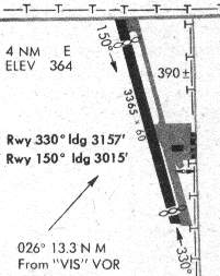
The 1981 DoD VFR Supplement (courtesy of John Clifford) depicted Alta as having a 3,365' asphalt Runway 15/33.
The diagram depicted a ramp on the east side of the runway with a few small hangars.
Ben Siebert recalled, “Alta Airport... I last landed there in December 1986 at night just as visibility was going below 1 mile.
The airport had lights - I often landed there at night before Reedley had lights,
and always saw the lights as I drove past it on Mountain View Ave in the years before the advent of pilot-controlled lighting.
It was always mainly a crop-duster field, and became more so as time wore on because it was a VFR field only,
but there were always a few retracts & light twins there.”
Alta Airport was still listed as an active civil airfield in the 1989 Airport/Facility Directory (according to Chris Kennedy).
It was described as having a single 3,365' asphalt Runway 15/33.
Todd Peasley recalled, “I used Alta Airport in 1992 at least once a week
to transport a business owner from Healdsburg to his Vegetable Packaging plant in Visalia.
At the time, there were half a dozen airplanes based there with shelters for at least a dozen but the airport was on it's last legs.
Weeds starting to grow up through the cracks in the concrete were always apparent.”
The last aeronautical chart depiction which has been located of Alta Airport was on the October 1993 San Francisco Sectional Chart (courtesy of Ron Plante).
It depicted Alta Airport as having a single 3,300' paved runway.
Dana Lubich recalled, “In 1997 the city of Dinuba hosted a 'Rutan Day', as Burt & Dick Rutan grew up there.
They helped open an exhibit at the local museum, showcasing their life’s achievements.
They spoke about flying out of the Alta airport east of Dinuba when they were young, which adds some celebrity status to the airport.”
Alta Airport apparently closed (for reasons unknown) at some point between 1993-97,
as it was depicted as an abandoned airfield on the September 1997 San Francisco Sectional Chart (courtesy of Ron Plante).
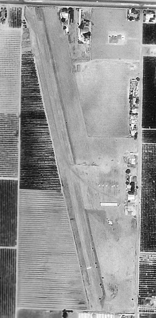
As of the 1998 USGS aerial photo, the Alta airfield consisted of a single 3,300' paved runway & parallel taxiway,
along with a ramp area east of the runway, with what looks like a single long, narrow hangar.
But there was no indication of any aircraft on the field.
A 2006 aerial view by Todd Peasley, looking southwest at the remains of Alta Airport.
A 2006 aerial view by Todd Peasley, looking north at the remains of the hangars at Alta Airport, with the former runway pavement visible at left.
Todd observed, “The ramp area has dirt piles all over with bulldozers & what appears to be freshly-grated dirt.
The hangars / shelters are still intact. There are dirt piles on the western middle portion of the runway.
The centerline is deteriorating but still visible. The concrete is intact but rough & chunked in some areas.”
A 2007 photo by Charles Irvin looking southeast along the remains of the runway at Alta Airport.
Charles reported “The body shop appears to be gone now, and the hangars look vacant.
No sign of runway lights or a beacon, so it was most likely a VFR-only airfield.”
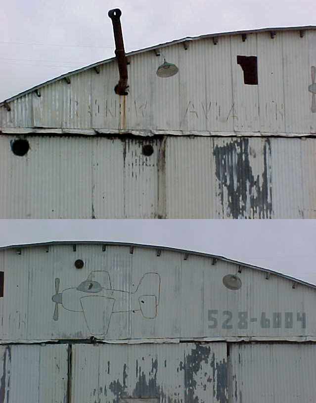
Two 2007 photos by Charles Irvin of the “Rainbow Aviation” legend still visible on a former hangar at the site of Alta Airport.
A circa 2010 aerial view looking east at the hangars which remain on the east side of Alta Airport.
The Alta Airport appeared to remain intact though deteriorated in an 8/27/12 aerial view looking north.
A 2011 photos looking west at the former hangars which remained on the east side of the Alta Airport site.
A 2022 photo showed the hangars along the east side of the Alta Airport site were removed at some point between 2011-2022.
Alta Airport is located south of the intersection of Avenue 416 & Road 114, one mile west of Orosi, CA.
____________________________________________________
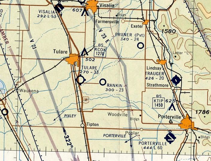
Rankin Field / Defense Plant Corporation Airfield, Tulare, CA
36.15, -119.25 (Southeast of Fresno, CA)
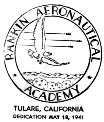
A postmark commemorated the 5/18/41 Dedication of Rankin Aeronautical Academy, Tulare.
Rankin Field was not yet depicted on the November 1939 Mt. Whitney Sectional Chart.
Tex Rankin was president of the Hollywood Motion Picture Pilots Association in 1940
when he signed a War Department contract to open a school to train U.S. Army pilots.
First flights began the following February at Mefford Field, on the outskirts of Tulare, CA.
Construction work on Rankin Field, 6 miles east, began the same month & finished in late spring.
To build the school the residents of the city of Tulare raised $300,000
to help defray the costs of procuring the land & initial construction of the buildings.
A postmark commemorated the 5/18/41 Dedication of Rankin Aeronautical Academy, Tulare.
The Rankin Aeronautical Academy accepted its first class of cadets in 1941.
Rankin Field became one of the 62 civilian owned flying schools in the US,
which collectively taught 1.4 million WW2 Army pilots to fly.
A circa 1941 aerial view of Rankin Field, as pictured on the back cover of "Rank'n'File",
"A high lift, double-exhaust, 1,000 hosspressure magazine published in the interest
of the Aviation Cadets of the Rankin, Aeronautical Academy, Tulare, CA.", Christmas 1941.
The photo is courtesy of Pat Thomas, whose father, Howard R. McCullough, was a flight instructor during WW2.
A circa 1941 photo by Loraine Bohnert (courtesy of Eloise Bohnert) of an AT-6 Texan, Vultee, and Stearman biplanes at Rankin Field.
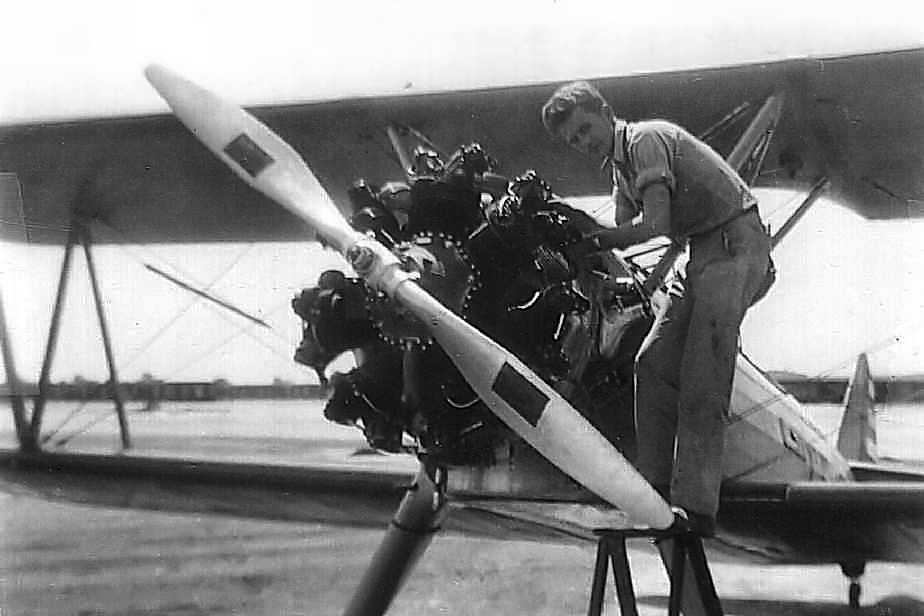
A circa 1941 photo by Loraine Bohnert (courtesy of Eloise Bohnert) of aircraft maintenance being performed on a Stearman biplane at Rankin Field.
Rankin Field had 140 instructors.
The cadets, or "dodos" as they were called when they arrived at flight school,
were trained in the air at a ratio of one instructor to each cadet.
That instructor would be the cadet's own personal teacher for the entire nine-week training period.
On the ground, cadets had aerobic training & went to aeronautic classes taught by civilians.
The training was very rigorous & the cadets were subjected to a quiz during class almost every day.
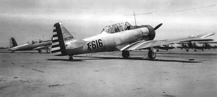
The cadets who trained at Rankin Field were taught to fly in one of 200 Stearman Biplanes.
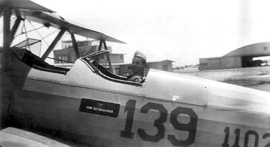
A circa 1941 photo by Loraine Bohnert (courtesy of Eloise Bohnert) of a pilot in the cockpit of a Stearman biplane at Rankin Field.
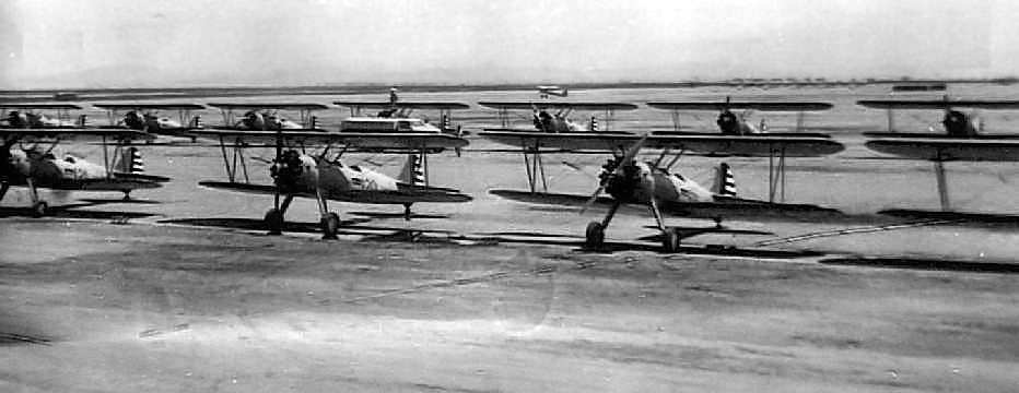
A circa 1941 photo by Loraine Bohnert (courtesy of Eloise Bohnert) of the large numbers of Stearman biplanes on the ramp at Rankin Field.
Eloise Bohnert recalled, "my husband, "Rainey" (Loraine) Bohnert was crew, or line chief
for Tex at the academy until he was drafted into the Air Force in 1941.
Tex not only trained first-rate pilots but aircraft mechanics as well.
My husband went on to win awards for his ability as an aircraft mechanic - learned from Tex himself."
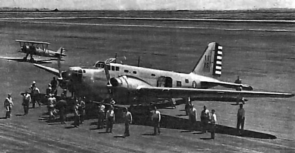
A circa 1941 photo of a Douglas B-18 Bolo bomber, noted to be “The biggest ship so far to 'set down' at Rankin Field.
It carried General Davenport Johnson, Group Captain D.V. Carnegie of the British Embassy, and Colonel Edward Lyons.”
The earliest aeronautical chart depiction which has been located of Rankin Field was on the August 1941 Mt. Whitney Sectional Chart.
Note that this chart showed Rankin Field about a mile west of its true location – perhaps an error by the chartmakers,
or perhaps an example of an intentional misinformation during the lead-up before WW2.
The earliest topo map depiction which has been located of Rankin Field was on the 1942 USGS topo map.
It depicted “Rankin Academy” as 2 small buildings, without any depiction of the airfield itself.
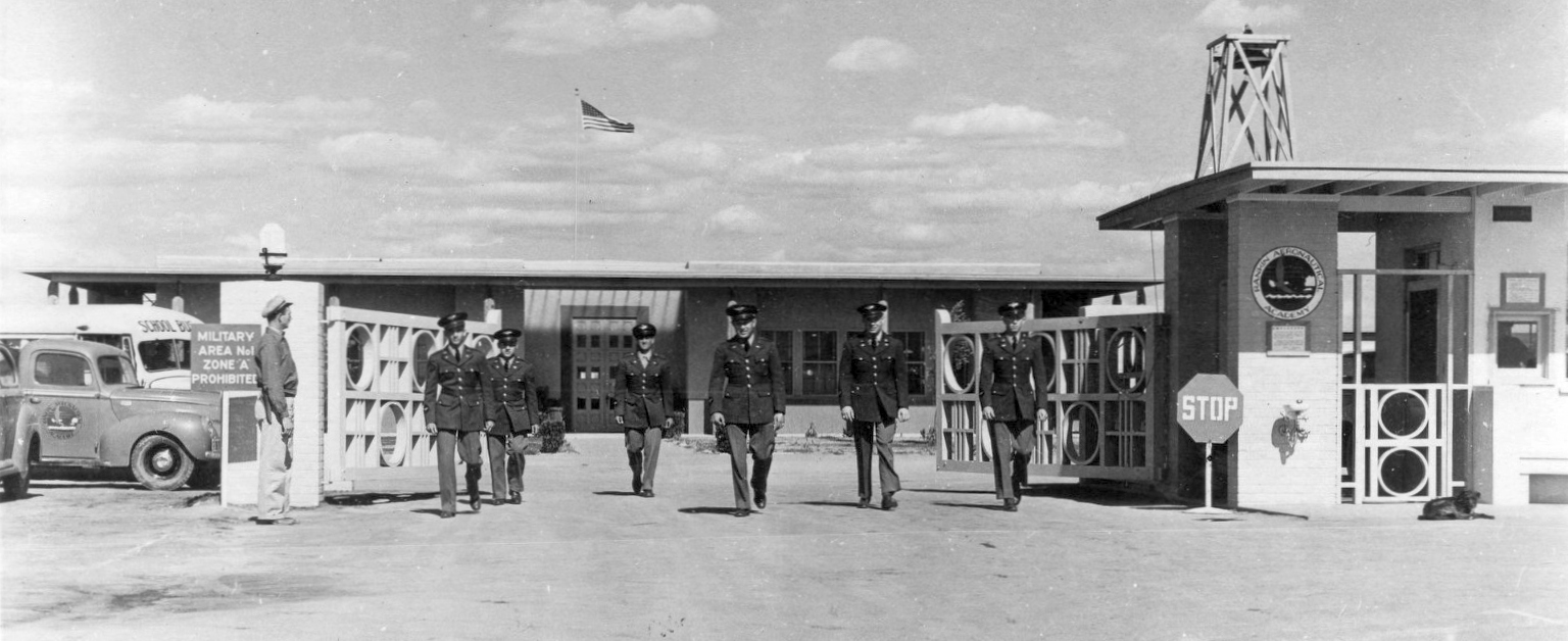
A 1942 photo by Phil Livingston of military personnel at Rankin Field's gate,
originally captioned “Through this gate pass the world's finest flyers, Rankin Aeronautical Academy, Tulare, CA.”
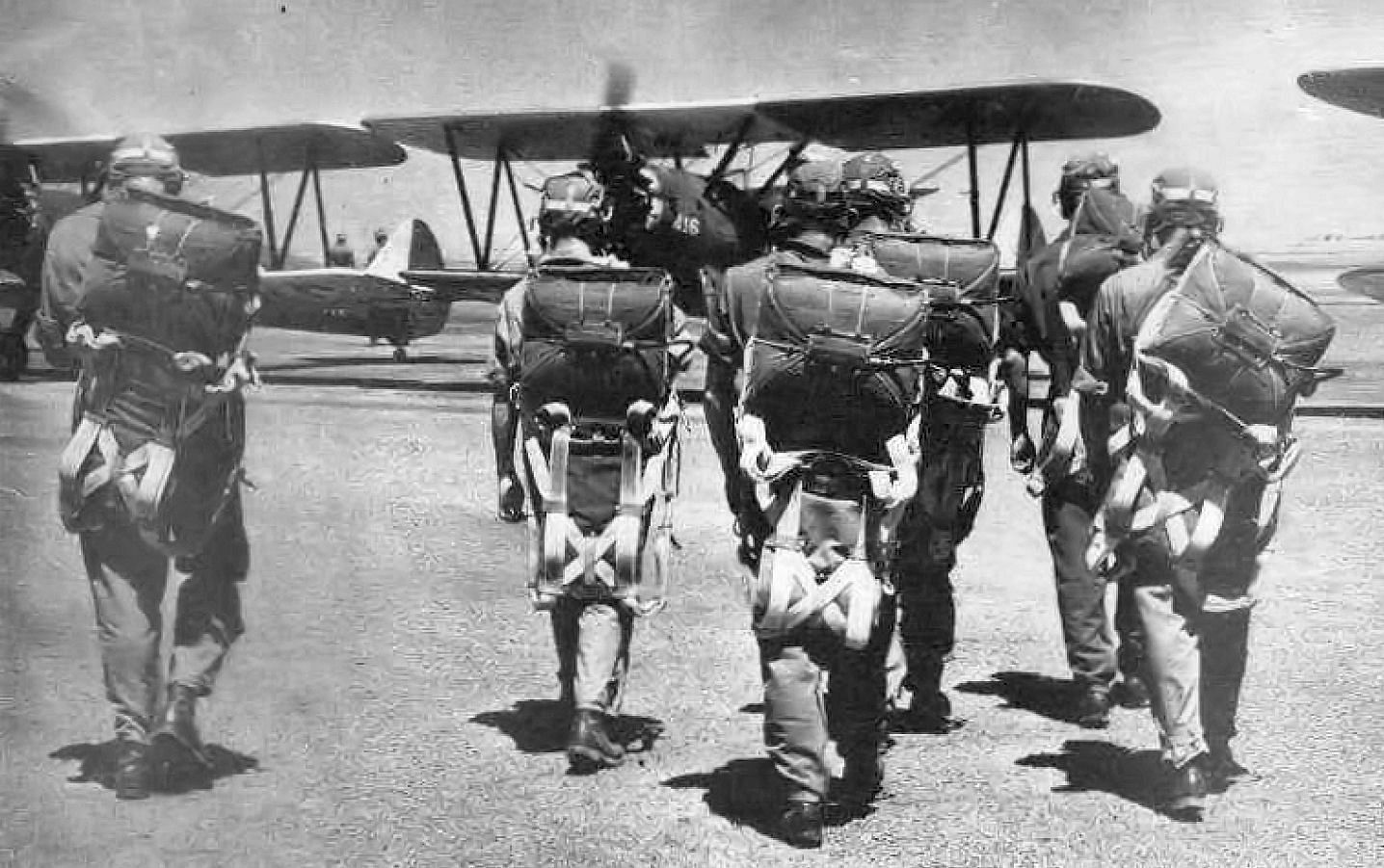
1943 USAAF photo of flight cadets at Rankin Field getting ready to train in their PT-17 Stearman biplanes.
![]()
The logo of the Rankin Aeronautical Academy.
Ralph Swenson reported, “My father-in-law (Henry Kisling) tells me that when he farmed near Pixley in the early 1940s,
he daily went to Rankin Field & took German prisoners back to his farm to work.
He is German himself so enjoyed talking with them in their language.”
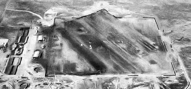
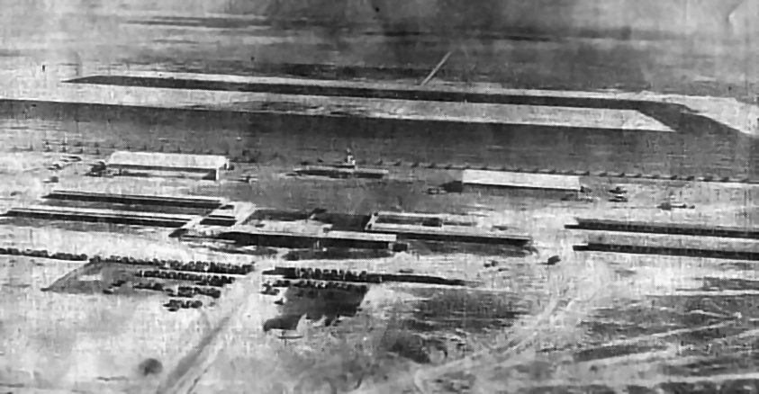
A circa 1943-45 aerial view looking north from the 1945 AAF Airfield Directory (courtesy of Scott Murdock)
depicted Rankin Field as having a square landing mat with several hangars along the west side.
Interestingly, note the curved earthen revetments which had been built on the southwest side of the field.
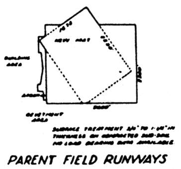
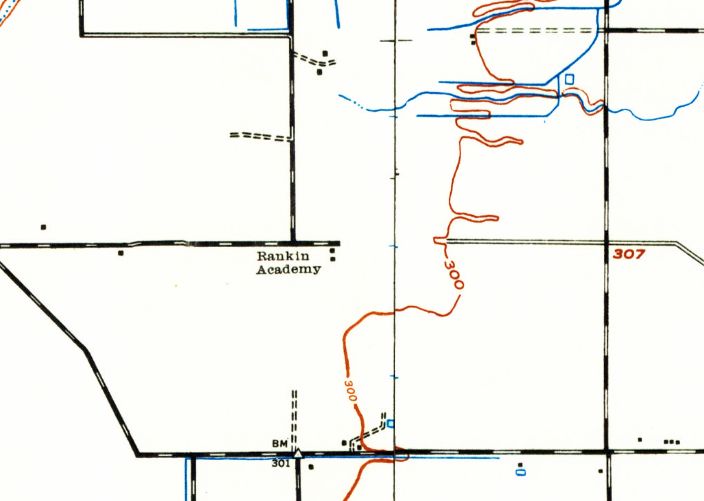
A 1944 USAAF diagram of Rankin Field (courtesy of John Voss)
depicted the airfield as consisting of a 2,300' x 1,800' rectangular "New Mat",
which was set at a diagonal angle over a previous landing area which was oriented east/west.
The ramp & buildings were adjacent to the west side of the landing area.
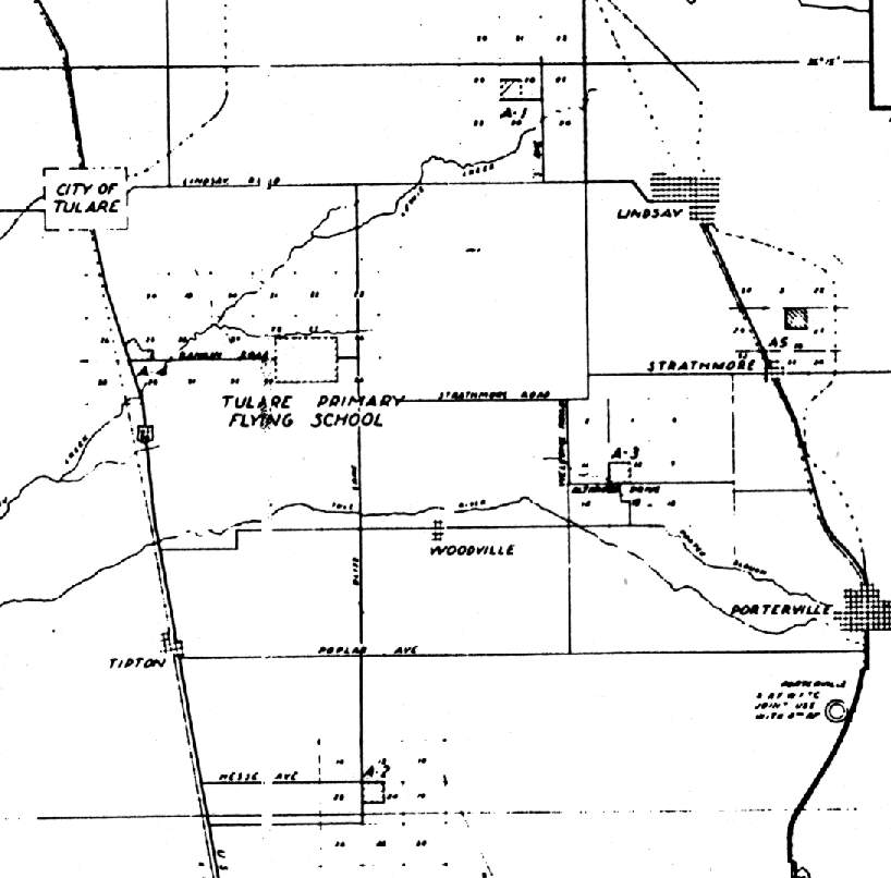
A 1944 USAAF map of Rankin Field (labeled "Tulare Primary Flying School") & its satellite airfields (courtesy of John Voss).
Rankin Field had a total of 5 auxiliary airfields during WW2.
A-1 Exeter, located 8 miles northeast of Rankin Field, is still open as a civil airport, Exeter Airport.
A-2 Tipton was located 10 miles south - it has no remains which have been identified.
A-3 Strathmore was located 8 miles east-southeast - it has no remains which have been identified.
A-4 Tulare Airport, located 6 miles west, is still open as a civil airport, Tulare Airport.
A-5 Trauger, located 12 miles east, is still open as a civil airport - Eckert Field.
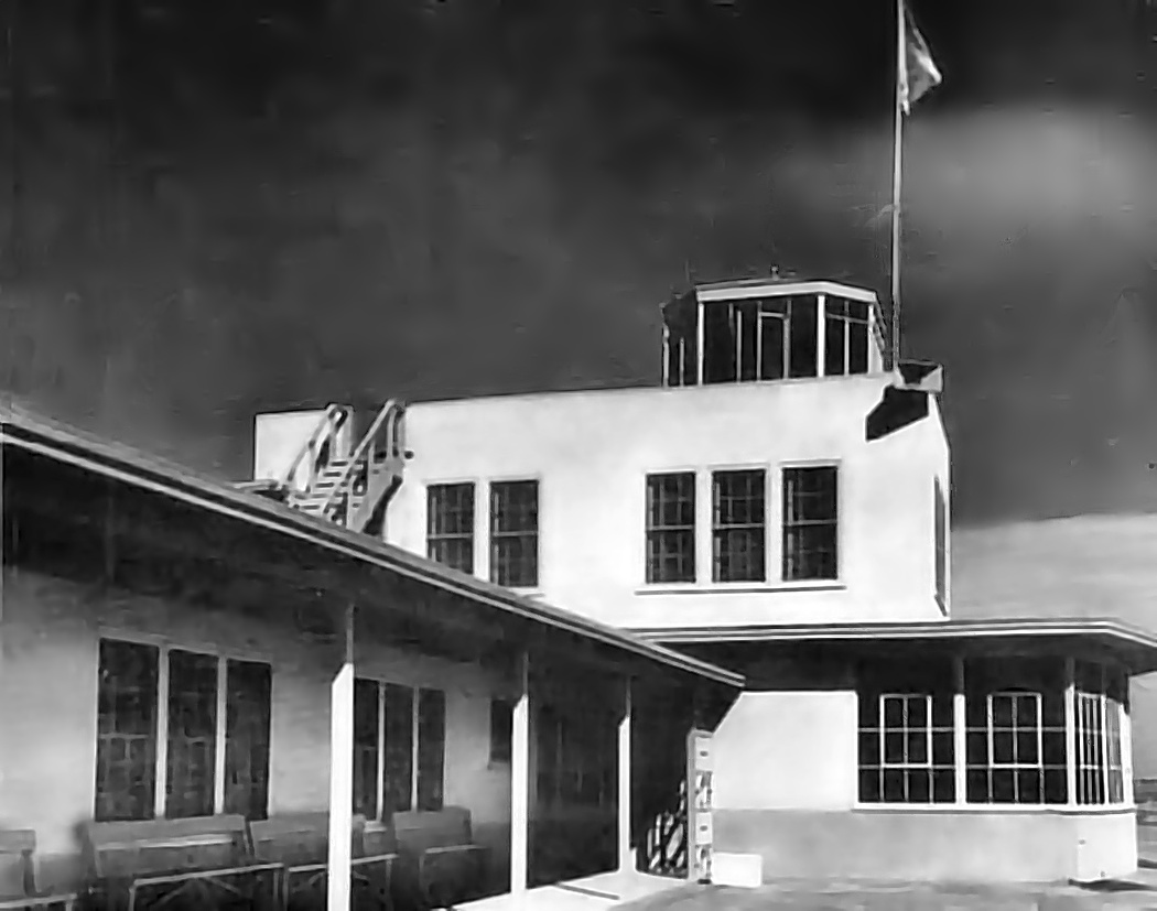
A 1944 photo of the Rankin Field control tower & operations building.
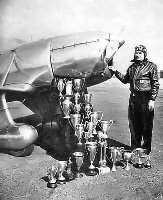
A 1944 USAAF photo of Tex Rankin & his flying trophies at Rankin Field.
“Rankin Primary” was depicted as a military airfield on a circa 1944 Tulare Lake AAF Aeronautical Chart (courtesy of Roger Connor).
The Rankin Aeronautical Academy was in operation until 1945,
having trained a total of 10,000 pilots.
Among those trained was Richard Bong, who later went on to become one of America's highest scoring aces,
and earned a Congressional Medal of Honor.
The 1945 AAF Airfield Directory (courtesy of Scott Murdock) described Rankin Field
as a 960 acre rectangular property within which was a 2,600' x 1,670' northwest/southeast oiled landing mat.
The field was said to have a single 200' x 100' wood & metal hangar,
to be owned by the City of Tulare, and to be operated by private interests.
A 1/1/46 aerial view (from the USCB Library) depicted Rankin Field as having the rectangular "New Mat" which was set at a diagonal angle over a previous landing area which was oriented east/west.
The ramp & buildings were adjacent to the west side of the landing area, but there were no aircraft visible on the field.
Note the 5 curved earthen revetments which remained from WW2 on the southwest side of the field.
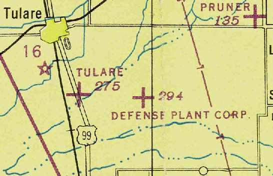
Rankin Field was labeled as “Defense Plant Corporation” on the February 1946 Mt. Whitney Sectional Chart (courtesy of Chris Kennedy).
The Defense Plant Corporation was responsible for financing & building many defense industrial facilities during WW2,
so it is possible the field may have (briefly) reverted to their control after the war.
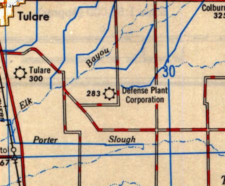
Rankin Field was still labeled as “Defense Plant Corporation” on the 1948 USGS topo map.
Rankin went back to being labeled “Rankin Field” on the February 1949 Mt Whitney Sectional Chart (according to Chris Kennedy).
It was described as having a 2,400' unpaved runway.
The September 1949 Mt. Whitney World Aeronautical Chart depicted Rankin Field as having a 2,700' unpaved runway.
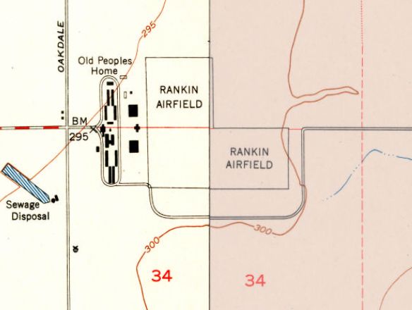
The 1951 USGS topo map depicted “Rankin Airfield” as a 2,500' L-shaped landing area.
The 2 former hangars were still depicted, but the former barracks buildings to the west were labeled "Old Peoples Home".
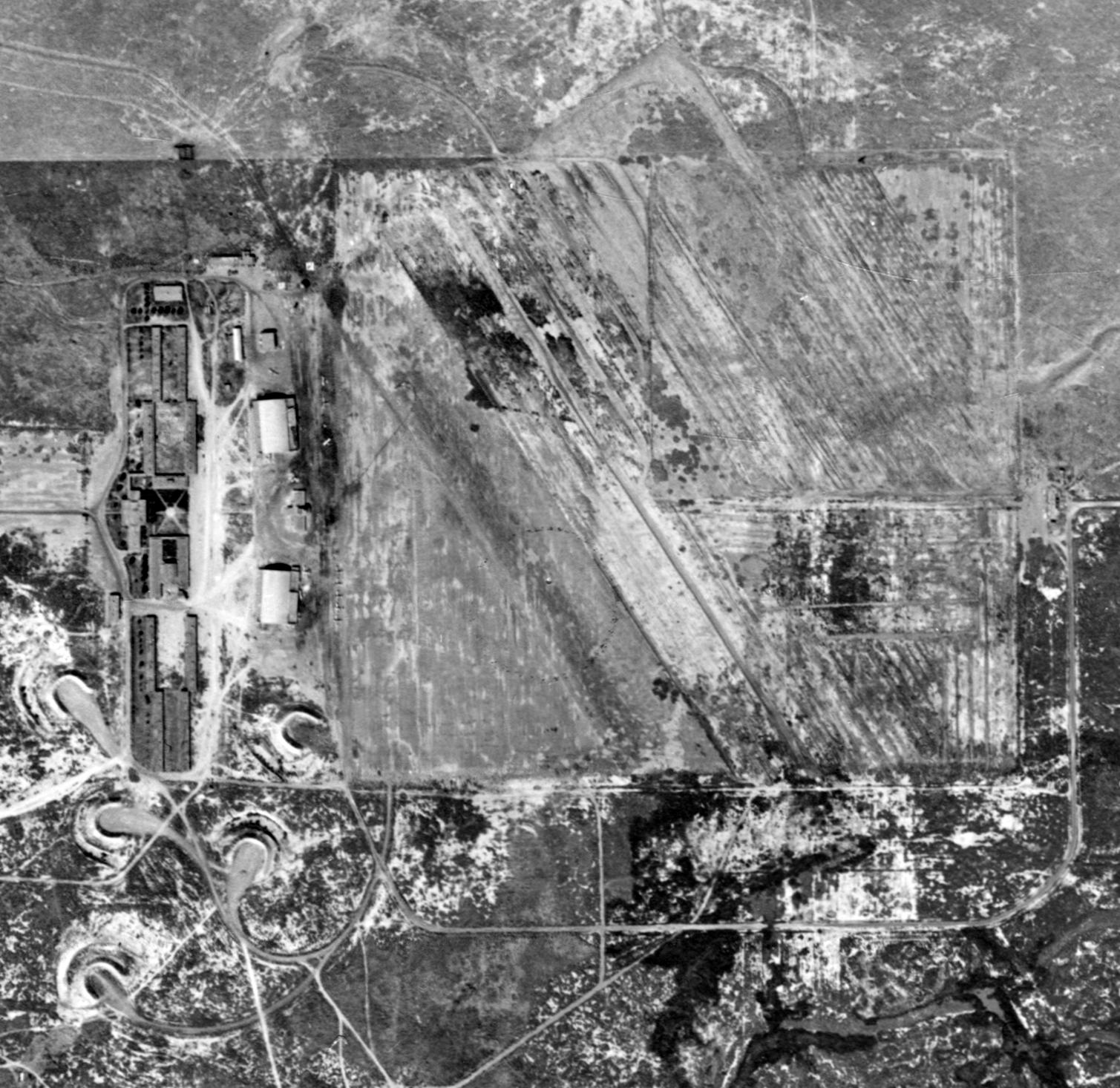
A 10/9/52 USGS aerial view of Rankin Field (from the UCSB Library) depicted the unpaved northwest/southeast runway, and the 2 large hangars & numerous other buildings along the west side.
A total of 8 aircraft were visible parked on the field.
Note the 5 curved earthen revetments which still remained from WW2 on the southwest side of the field.
The last aeronautical chart depiction which has been located of Rankin Field was on the March 1959 Mt. Whitney Sectional Chart.
It depicted Rankin as having a 2,300' paved runway.
Rankin Field was evidently abandoned at some point in 1959, as it was no longer depicted on the September 1980 Mt. Whitney Sectional Chart.
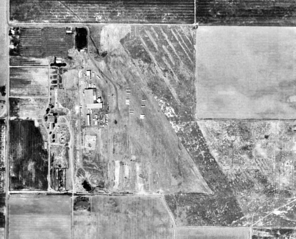
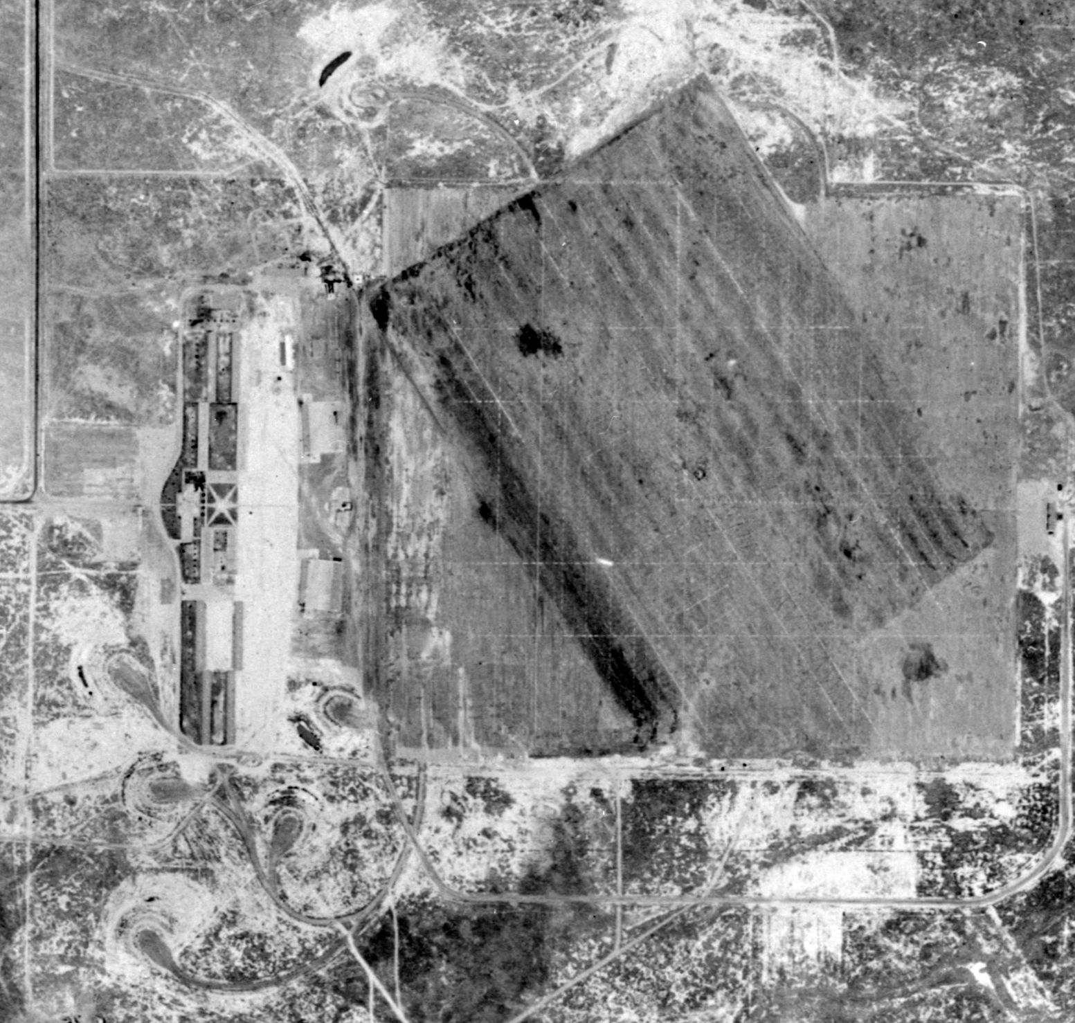
A 7/24/69 USGS aerial photo did not show any sign of aviation usage at Rankin Field.
The diagonal orientation of the landing area was still recognizable, but much of the land had been returned to cultivation.
The 5 curved earthen WW2 revetments on the southwest side had been removed at some point between 1954-69.
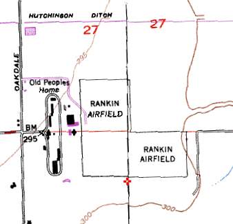
On the 1991 USGS topo map, “Rankin Airfield” was depicted as a 2,500' L-shaped landing area.
The buildings along the west side of the airfield were labeled "Old People's Home".
One of the former hangars was still depicted, whereas the southern hangar had apparently been removed.
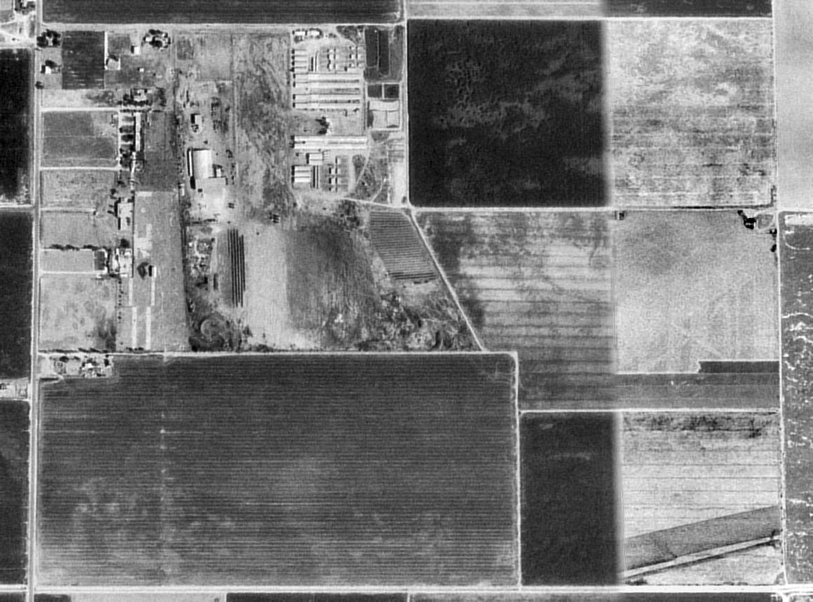
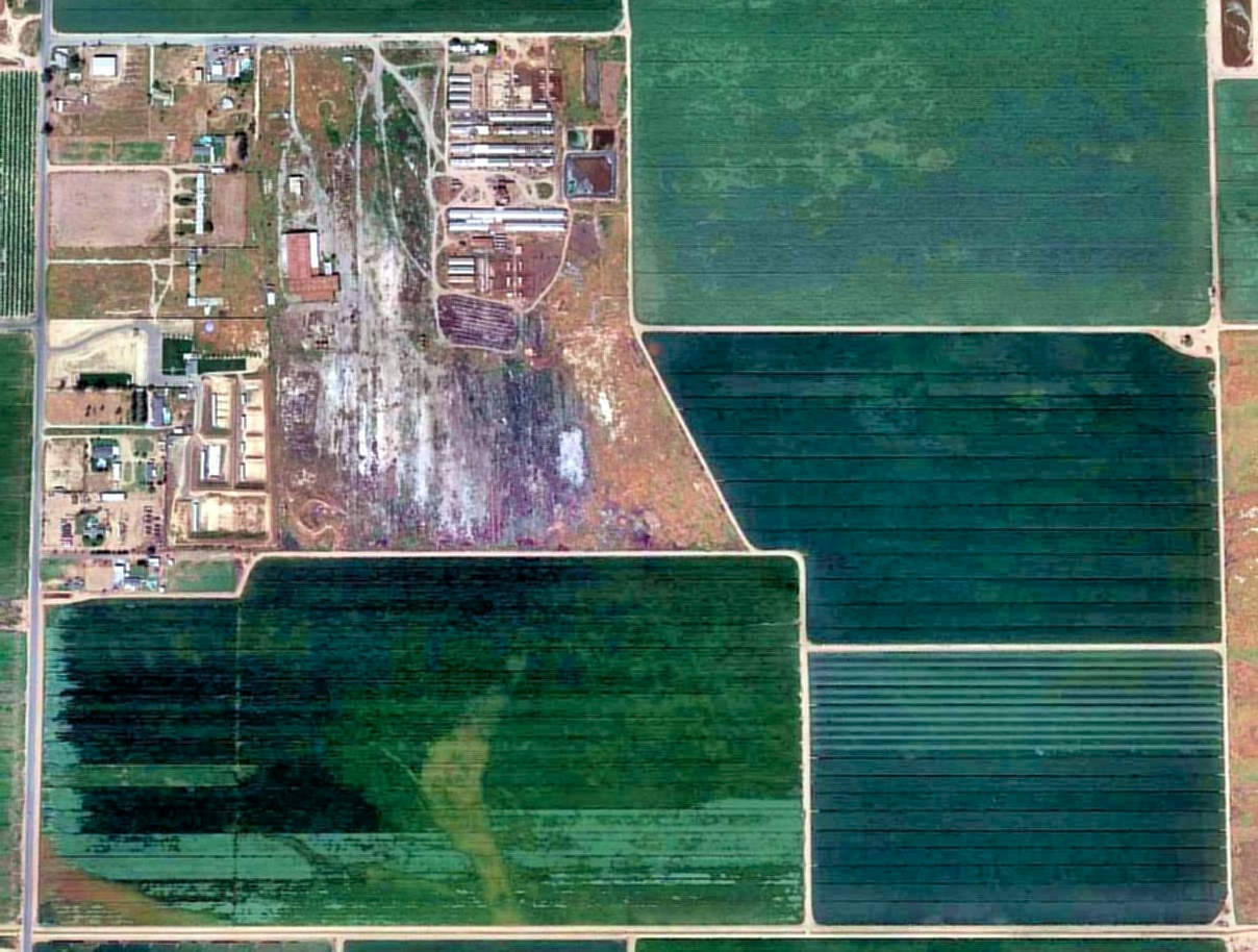
As seen in the 1994 USGS aerial photo, the landing area at Rankin has been returned to farmland,
but the faint diagonal outlines of the runway was still perceptible in the middle & southeast corner of the photo.
A complex of buildings had been added on the northeast side of the former landing mat at some point between 1969-94.
Since 1996 a portion of Rankin Field has been reused as a firing range for the Tulare County Deputy Sheriff's Association.
A 1997 photo by Dana Lubich of the Rankin guard shack, with the base administration building in the background.
Dana Lubich recalled, “In 1997 there was a reunion of graduates from Sequoia & Rankin airfields that took place.
It afforded an opportunity to see all of Rankin up close (the public was invited),
as most of it is privately owned (only the Administration Building/Guard Shack, paintball course & a picnic area are owned by a sheriff’s deputy organization,
which opens the front part up to the public for different events).
They had a good old-fashioned 'hay ride' tour through the former base (a tractor pulled a flatbed trailer with bales of hay to sit on)!
We even got to drive through the remaining hangar, with a rusting antique collection of cars.
The tarmac area was stained a reddish-orange from drying their agricultural product (can’t remember what product it was).
The cement foundations of some buildings, long since burned down, remained.
Although, it was stated that some that survived were relocated on the property as farm labor housing.
Others were relocated to a motel at the off ramp at Highway 99 & East Rankin Road, right across from Tulare’s Mefford Field.
The motel was the sight for many vice busts over the years before it was either torn, or burned, down - a rather inglorious ending to the base buildings.
The cement foundations are all that are left - but the motel’s sign still remains!
The cement 'foundations', that the tour pointed out, is an area I haven’t been able to identify as having had buildings on,
in photos I’ve later seen in years since, but they definitely looked like individual foundations when we drove over them.
And the houses in the northwest corner of the property were not specifically stated as original base buildings,
but they were the only old buildings intact, aside from the Administration Building & guard shack.”
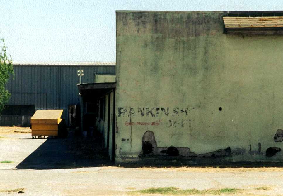
A 1997 photo by Dana Lubich, showing “Rankin” still visible painted on the rear of a Rankin hangar.
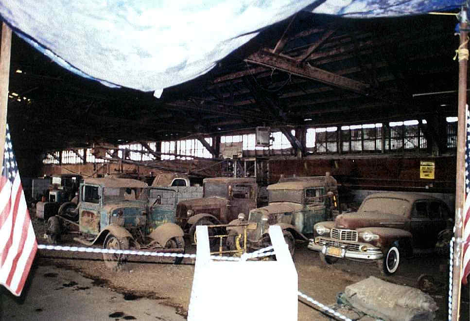
A 1997 photo by Dana Lubich showing a fascinating assemblage of antique cars stored inside a Rankin hangar.
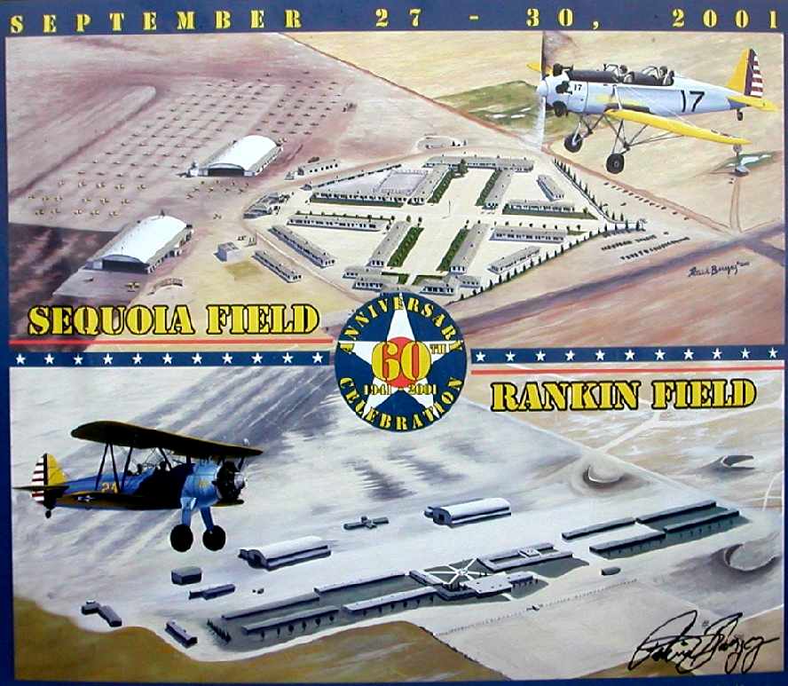
A print designed & produced by Patrick Barszcz for the 60th Anniversary of Sequoia Field & Rankin Field on September 27-30, 2001.
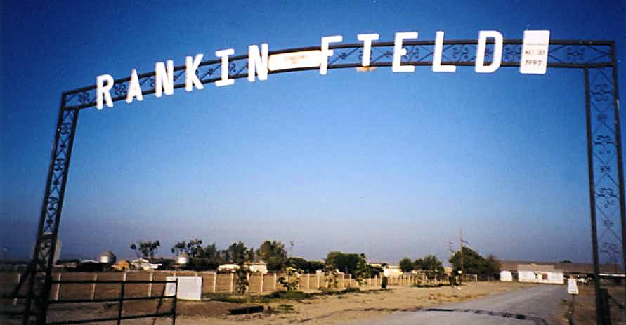
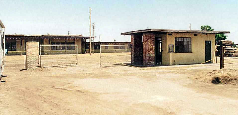
A circa 2000s photo by Dan MacPherson of the entrance sign at Rankin Field.
Dan reported that 1 hangar, a guard shack, administration building, and flagpole still existed at the site of Rankin Field.
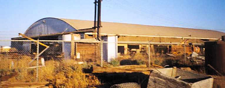
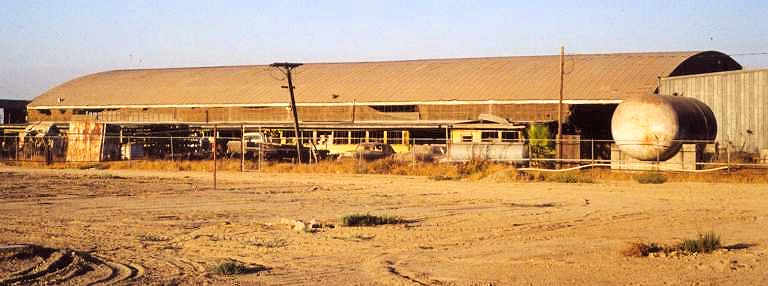
Two circa 2000s photos by Dan MacPherson of a remaining WW2-era hangar which still stands at Rankin Field.
A event is being planned to commemorate the 60th anniversary of Rankin Field.
A 2015 aerial photo shows that one of Rankin Field's former hangars still remains, as well as some smaller buildings.
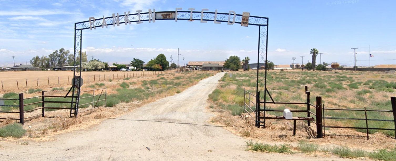
A 2022 photo looking east at the Rankin Field entrance sign, with the former hangar visible in the center.
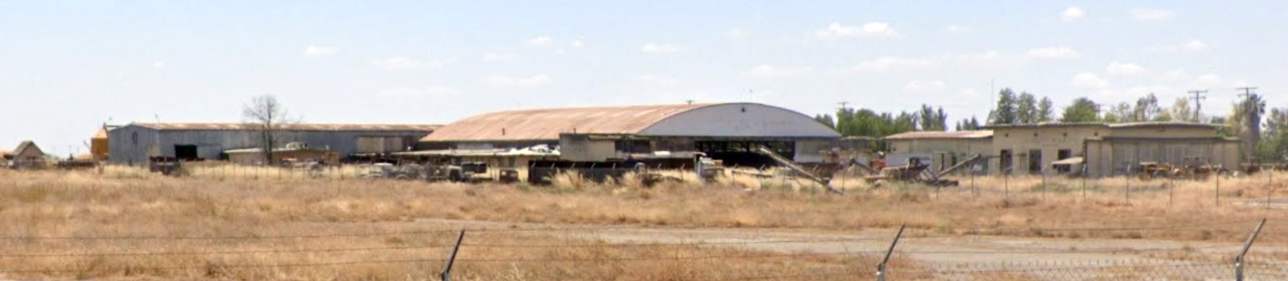
A 2022 photo looking southwest at the former Rankin Field hangar & other buildings.
The site of Rankin Field is located east of the intersection of Avenue 200 & Road 140, four miles east of Tulare Airport.
Thanks to Scott Anger (whose grandfather was a WW2 trainer at Rankin Field) for pointing out this airfield.
See also: "Wings Over Tulare County", Valley Voice 8/1/01.
____________________________________________________
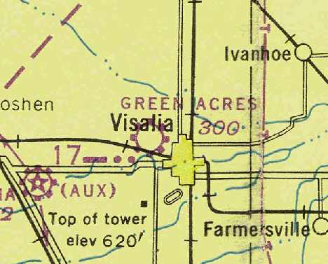
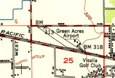
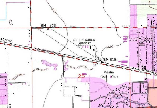
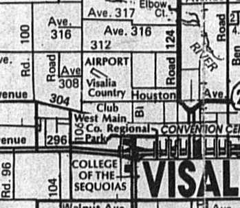
Green Acres Airport (2Q1), Visalia, CA
36.34, -119.33 (Southeast of Fresno, CA)
Green Acres Airport, as depicted on the February 1946 Mt. Whitney Sectional Chart (courtesy of Chris Kennedy).
The date of construction of the former small general aviation airport is unknown.
According to a history of Visalia Municipal Airport,
what was eventually known as Green Acres Airport was originally named Hyde Field,
and was in operation as far back as 1927.
No airfield was depicted at this location on the 1943 Mt Whitney Sectional Chart (according to Chris Kennedy),
on a circa 1944 Tulare Lake AAF Aeronautical Chart (courtesy of Roger Connor),
or in airport directories from 1937, 1944, or 1945 (it may have been overlooked due to its modest size).
The earliest depiction of Green Acres Airport which has been located
was on the February 1946 Mt. Whitney Sectional Chart (courtesy of Chris Kennedy).
It was depicted as a commercial or municipal airport.
Dana Lubich recalled that his “grandfather took flying lessons from Chick Erhorn during the 1940s” at Green Acres.
Sharon Austin recalled, “Green Acres was operated by my father-in-law [Morell Austin] from some time after WWII.
Morell had been employed during the war at the Rankin Aeronautical Academy,
and after the war he continued as a flight instructor at Green Acres.
In addition to instruction, he did a fair amount of charter flying,
as well as support to the Forest Service & National Park Service, especially during forest fires.
He did a little bit of crop dusting from Green Acres.”
The 1949 USGS topo map depicted Green Acres Airport as having a wide northwest/southeast runway,
with several small buildings (hangars?) next to the east side of the runway.
The 1949 Mt. Whitney Sectional Chart (courtesy of Chris Kennedy)
depicted Green Acres Airport as having a 2,700' unpaved runway.
The earliest photo which has been located of Green Acres Airport
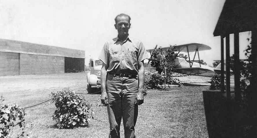
was a circa late 1940s - early 1950s photo of Morell Austin in front of a biplane at Green Acres Airport (courtesy of Sharon Austin).
An undated aerial view looking north at Green Acres Airport from the 1950 Air Photo Guide (courtesy of Kevin Walsh).
The guide described Green Acres Airport as having a 3,000' turf Runway 10/28, and listed the managers as M.B. Bartin & M.L Austin.
A 10/10/52 aerial view (from the UCSB Library) depicted Green Acres Airport as having a northwest/southeast unpaved runway, with 3 hangars & 15 single-engine planes on the southeast side.
Sharon Austin recalled, “Green Acres was operated by my father-in-law [Morell Austin] until May of 1953.
He then opened his own field [Crop Air at Piepgrass Airport] east of Green Acres in 1953.”
A 1953 Flight Chart (courtesy of Scott O'Donnell) depicted Green Acres Airport as having a 2,800' unpaved runway.
The 1962 AOPA Airport Directory described Green Acres Airport as having a single 2,800' sod & oiled Runway 12/30.
It listed the operator as Green Acres Airport.
The 1969 USGS topo map depicted several small buildings (hangars?) next to the east side of the runway.
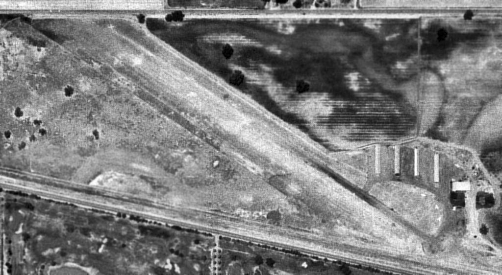
The last aerial photo which has been located showing Green Acres Airport in use was a 7/24/69 USGS aerial view.
It depicted Green Acres as having a northwest/southeast runway, with 5 hangars & 4 single-engine planes on the east side.
John Clark recalled, “Green Acres Airport in the 1960s & 1970s... My uncle Arnold Whisman was owner of Arnold's Aerodrome.
I learned to fly there. My best memory is of my first landing.
I dumped a Beech Sundowner on the 2,300' x 50' runway like a sack of potatoes.
I believe Arnold either owned the airport outright or leased the field over the period 1960s-70s.
He had a fleet of Stearman crop dusters he ran & also operated an FBO that offered air charter & lessons.
He had a Barron there among other planes of which the Sundowner was one. The trainers were Grummans if I recall correctly.
Arnold was not a Cessna fan & did not think much of Piper either until the Comanche was produced.
Arnold had a V-tailed Bonanza & really wouldn't put family in anything that wasn't Beech.
I think Arnold was a fine pilot & a good uncle.”
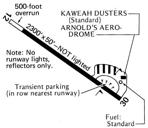
The Green Acres runway had been paved by 1976, as the 1976 Pilot's Guide to CA Airports (courtesy of Chris Kennedy)
depicted the field as having a 2,300' paved Runway 12/30 (with a 500' overrun at the northwest end).
A total of 5 hangars were situated on the north side of the east end of the runway, at which was located Kaweah Dusters & Arnold's Aerodrome.

The last photos which have been located showing aircraft at Green Acres Airport was a series of January 1976 photos by John Whitehead (courtesy of Jay Sherlock).
This photo showed Stearman PT-13D N5025V of Kaweah Crop Dusters. Jay Sherlock observed, “You can just make out 'Green Acres Airport' stenciled on the upper fuselage panel just aft of the cockpit.”

A January 1976 photo by John Whitehead (courtesy of Jay Sherlock) of Stearman PT-13D N5000V of Kaweah Crop Dusters.
The 1982 AOPA Airport Directory described Green Acres as having a single 2,800' asphalt Runway 12/30, and listed the operators as Kaweah Crop Dusters & Action Aviation.
Dana Lubich recalled of Green Acres starting in 1983, “I remember seeing only crop dusters, and Jeff Davis’ beautiful T-6 Texan, flying out of there.
The tall trees from the Visalia Country Club golf course, which line that stretch of Goshen Avenue, were quite an obstacle on approach.
It seemed that the airplanes just skimmed over the tree line.”
From 1985-2001, Kaweah Crop Dusters conducted an environmental cleanup of DDT & other hazardous materials at the Green Acres Airport.
Green Acres Airport, as depicted on the 1987 CA Aeronautical Chart (courtesy of John Voss).
Green Acres was still listed among active airports in the 1989 Airport/Facility Directory (courtesy of Chris Kennedy).
The field was described as having a single 2,800' asphalt Runway 12/30,
and the remarks included, "Ultralight activity on & in vicinity of airport."
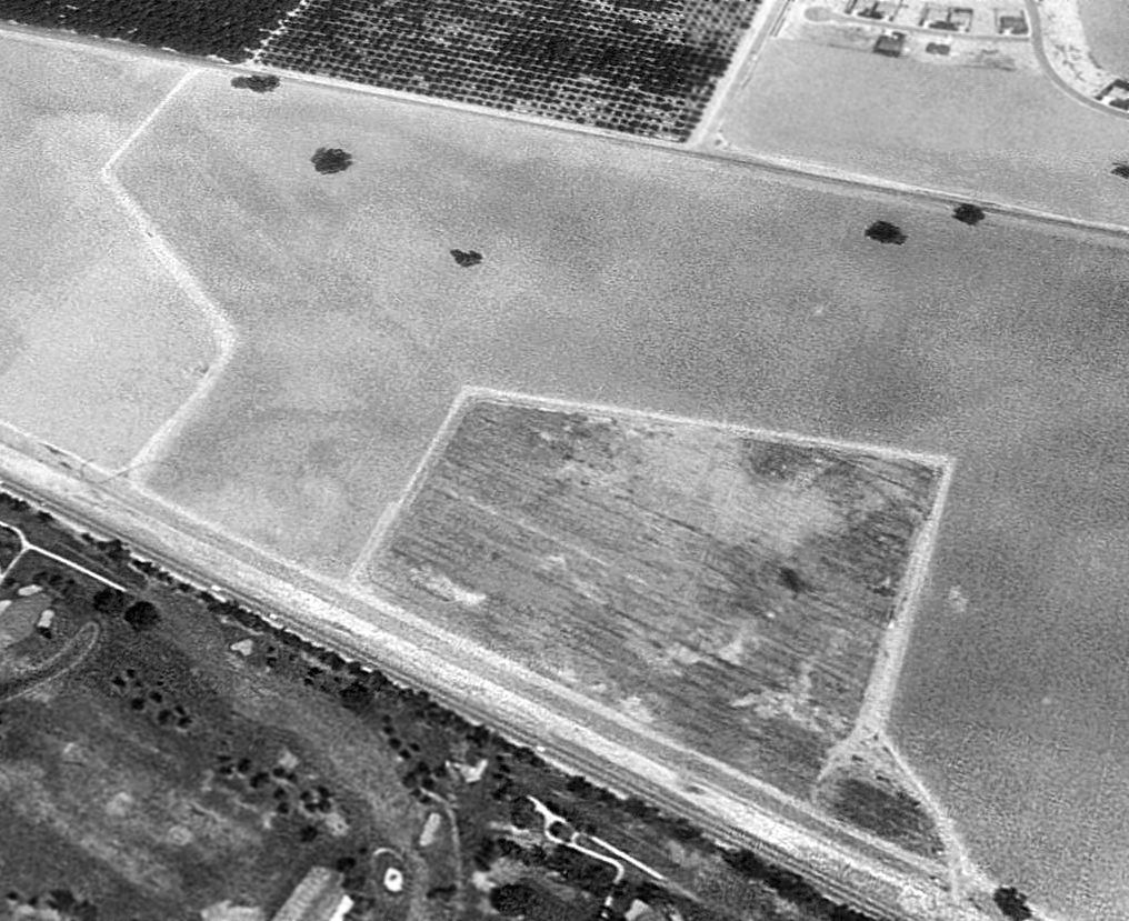
Green Acres Airport was apparently closed (for reasons unknown) at some point between 1989-94,
as by the time of a 1994 USGS aerial view looking northwest, the former runway had been removed, with the area returned to farming.
Only a faint trace of the former Runway 12/30 could still be recognized in the agricultural field.
There was also no trace remaining of any buildings at the site.
Dana Lubich recalled of Green Acres, “When they tore the airport down, crops of carrots were grown on the property & destroyed,
year after year, since carrots absorb toxins in the ground.
This was necessary because of pesticide tanks that leaked over time from the crop dusting outfits operating there.
(I know rabbits run wild in that area, and wondered how many 'croaked' if they got a hold of some.
Fortunately, our local newspaper never reported any giant, mutated rabbits either…)”
A single northwest/southeast runway, labeled simply as “Airport”,
was still depicted at Green Acres on a 1998 Visalia Compass Map (courtesy of Dana Lubich).
Green Acres was no longer depicted at all (even as an abandoned airfield) on the 1998 World Aeronautical Chart.
Charles Irvin reported in 2007, “Green Acres Airport... as of a year or two ago, it's all tract homes, and the empty field is no more.”
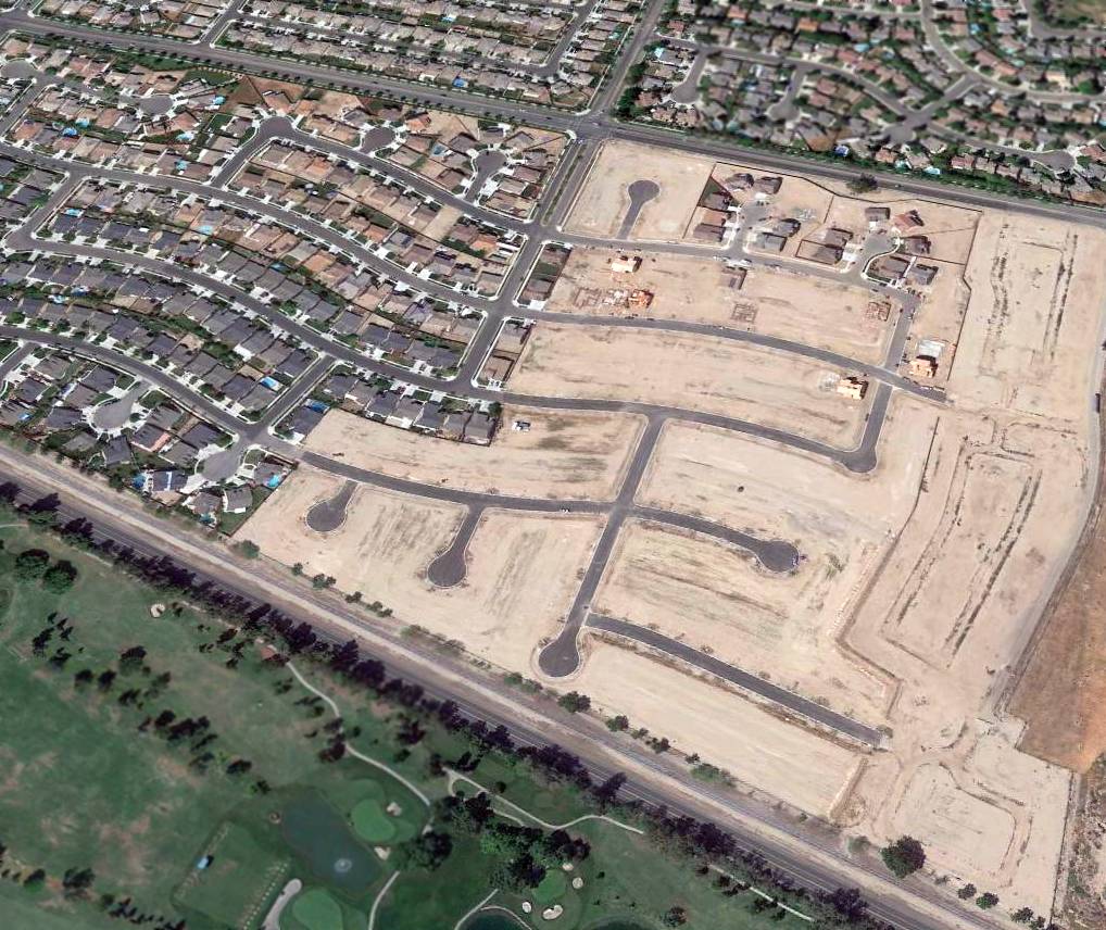
A 2015 aerial view looking northwest shows no trace remained of Green Acres Airport, with the property being covered by dense housing.
The site of Green Acres Airport is located southeast of the intersection of West Houston Avenue & North Demaree Street.
____________________________________________________
Since this site was first put on the web in 1999, its popularity has grown tremendously.
If the total quantity of material on this site is to continue to grow,
it will require ever-increasing funding to pay its expenses.
Therefore, I request financial contributions from site visitors,
to help defray the increasing costs of the site
and ensure that it continues to be available & to grow.
What would you pay for a good aviation magazine, or a good aviation book?
Please consider a donation of an equivalent amount, at the least.
This site is not supported by commercial advertising –
it is purely supported by donations.
If you enjoy the site, and would like to make a financial contribution,
you
may use a credit card via
![]() :
:
Please consider checking the box to make a monthly donatation.
For a mailing address to send a check, please contact me at: paulandterryfreeman@gmail.com
If you enjoy this web site, please support it with a financial contribution.
This site covers airfields in all 50 states.