
Abandoned & Little-Known Airfields:
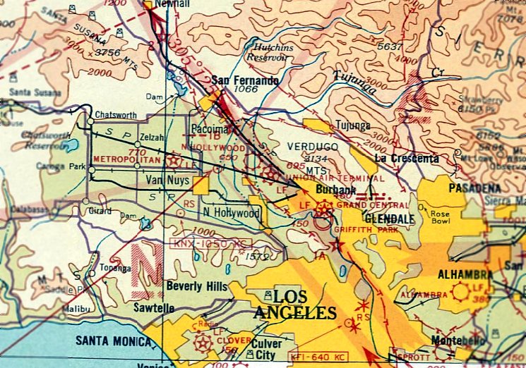
California: San Fernando area
© 2002, © 2024 by Paul Freeman. Revised 1/20/24.
This site covers airfields in all 50 states: Click here for the site's main menu.
____________________________________________________
Please consider a financial contribution to support the continued growth & operation of this site.
For the 6th year, the CA pages of this website are sponsored by the California Pilots Association:
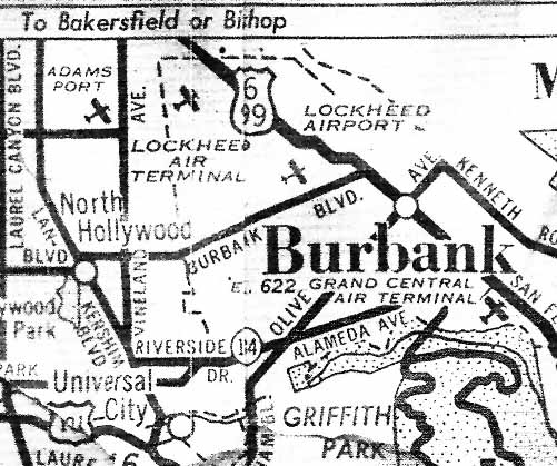
6-S Ranch Airpark (revised 1/13/19) - Bob Lloyd Airport / Adams Port (revised 9/6/23) - Lockheed Aircraft Company Plant B-1 (revised 1/20/24)
Indian Dunes Airport (revised 1/20/24) - Saugus Intermediate Field / Newhall Airport (revised 9/22/23)
San Fernando Airport (revised 4/6/20) - Wilson Airport / North Hollywood Airport (revised 4/7/20) - Zitto Airport (revised 7/28/19)
____________________________________________________
Zitto Airport, Los Angeles, CA
34.186, -118.38 (North of Downtown Los Angeles, CA)
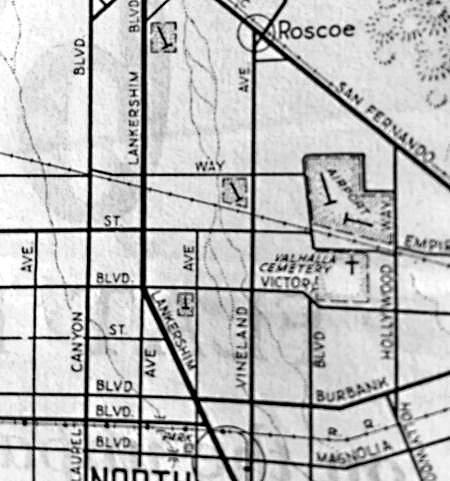
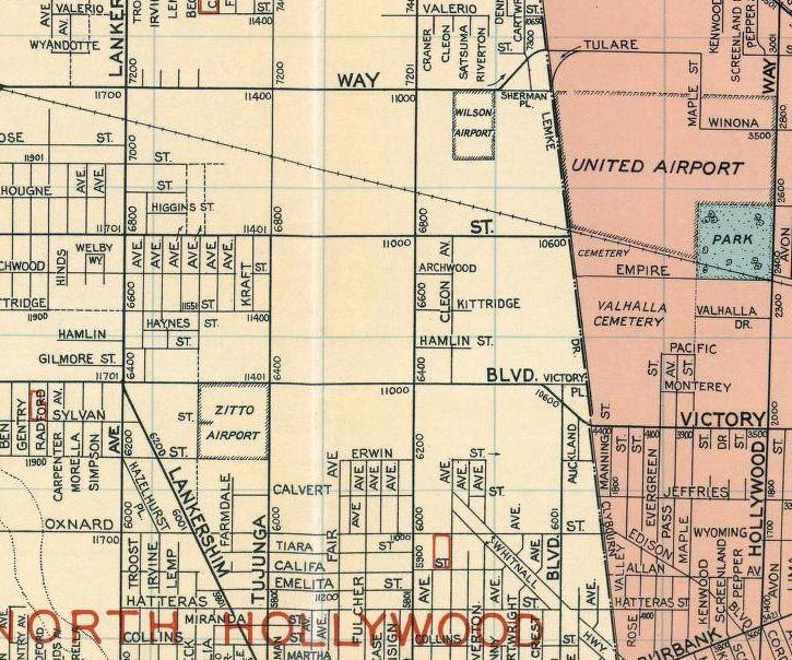
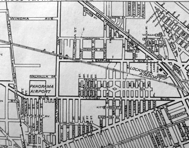
Zitto Airport, as depicted (the rectangular property outline below-left of the center of the image with the inverted “T” symbol)
on a circa early 1930s street map (courtesy of Kevin Walsh).
The date of construction has not been determined of this small, short-lived airport in the middle of Los Angeles.
Zitto Airport was not yet depicted on a 1929 street map (courtesy of Kevin Walsh),
or 1932/34/36/38/39 LA Sectional Aeronautical Charts.
The earliest depiction which has been located of Zitto Airport was on a circa early 1930s street map (courtesy of Kevin Walsh).
It depicted Zitto Airport as a rectangular property outline with a “T” symbol used to denote airports on the map.
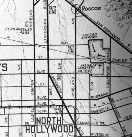
A June 1936 street map (courtesy of Kevin Walsh)
depicted Zitto Airport as a rectangular property outline below-left of the center of the image with the inverted “T” symbol.
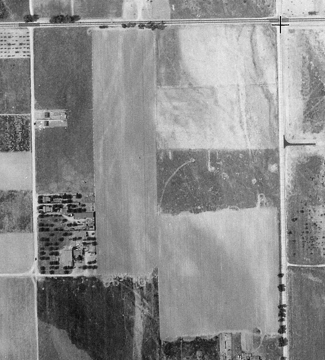
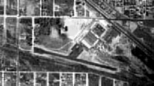
The only photo which has been located of Zitto Airport was a 5/13/37 USGS aerial view.
It appeared to depict Zitto Airport as having an unpaved north/south runway, with a few small buildings on the west side.
The earliest labeled depiction which has been located of Zitto Airport
was a 1938 Goshua street map (courtesy of Kevin Walsh), which depicted it as a square property outline.
The last depiction which has been located of Zitto Airport was on a 1938 street map (courtesy of Kevin Walsh), which depicted it as a square property outline.
Zitto Airport was presumably closed at some point between 1938-40,
as a 1940 street map (courtesy of Kevin Walsh) showed streets covering the site of the airport.
A 1952 aerial photo showed no trace of Zitto Airport, with the site having been densely redeveloped with housing.
A 2015 aerial view showed no trace remaining of Zitto Airport.
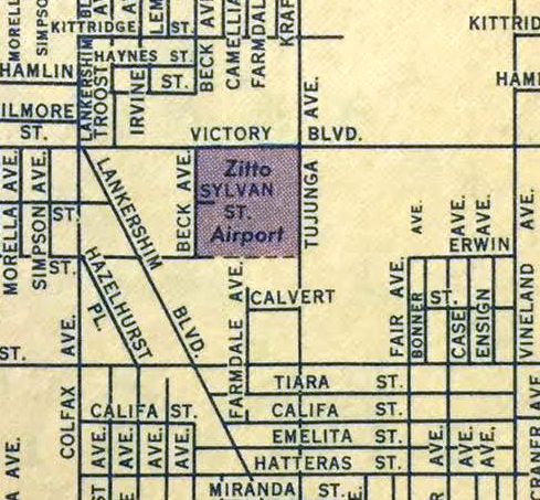
The site of Zitto Airport is located southwest of the intersection of Victory Boulevard & Tujunga Avenue.
Thanks to Rex Ricks & Andrew Laverdiere for pointing out this airfield.
____________________________________________________
Indian Dunes Airport (4CA4), Valencia, CA
34.424, -118.638 (Northwest of Los Angeles, CA)
A 1969 aerial view depicted a single unpaved runway at Indian Dunes.
The Indian Dunes airfield was evidently constructed at some point between 1964-69, as it was not depicted at all on a 1959 aerial view,
the August 1964 LA Local Aeronautical Chart (courtesy of Donald Felton), nor the 1967 USGS topo map.
The earliest depiction of the airport which has been located was on a 1969 aerial view.
It depicted Indian Dunes as having a single unpaved northeast/southwest runway.
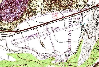
The earliest map depiction which has been located of the Indian Dunes Airfield was on the 1969 USGS topo map.
It depicted the runway, but labeled it merely as "Landing Strip".
Peter Albiez reported, “I am a Special Effect Coordinator and was in charge of the Prop Shop division
(we made the special props & aircraft mock-ups for the feature & TV shows)
of the Special Effects Department at Universal Studios in the 1970s.
The airport at Indian Dunes was built by the Newhall Land & Farming Company.
It & the hangar were for the Corporation’s aircraft & was always owned by them.
The areas that were used for filming of The Black Sheep Squadron TV series [1976-78]
was also used by many other films & TV shows & rented from Newhall Land.”
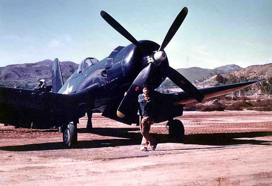
A 1976 photo by Randy Beloff (courtesy of Dan MacPherson) of Dan MacPherson in front of John Schafhausen's F4U-7 Corsair
used in the filming of the "Black Sheep Squadron" TV show at Indian Dunes.
Herbert Cole recalled, "When I was younger I remember passing by an airstrip next to the Indian Dunes motocross races.
My first memory of the field would be around Summer 1977.
Later I found out that the strip was the same one used in filming the 'Black Sheep Squadron' series."
Robert Conrad, star of the Black Sheep Squadron show, said that during filming of the show, "I lived in a trailer off of Highway 126.
They filmed The Black Sheep Squadron right there at Indian Dunes.
Sometimes I’d fly in to work from Van Nuys Airport, just to show them I was the real thing."
Dan MacPherson recalled, "I was fortunate enough to have been around in those days.
There were 4 Corsairs used for the filming: an F4U-7 belonging to John Schafhausen, an F4U-4 belonging to Tom Friedkin,
an FG-1D (Goodyear) belonging to David Tallichet, and my favorite, an F4U-1 belonging to the Planes of Fame museum at Chino.
The planes would be delivered prior to the filming, and the pilots would be ferried home by other planes.
The pick-up plane from the Air Museum at that time was a North American O-47B.
I had the privilege of flying in to Indian Dunes in this airplane - grand entry-low pass, pitchup & break.
There were already 2 Corsairs on the ground. While we were on the ground, 2 Cessnas in formation discovered the Corsairs & began circling excitedly.
While they we circling, one of the producers, unseen until now, did a low pass in another Corsair - right through the flight of Cessnas.
He then did a roll, pitched up & landed. The Cessnas scattered. I would have loved to hear the conversation."
Dan also described several other vintage aircraft used in the Black Sheep filming at Indian Dunes.
"There was 'the transport' which was a DC-3 owned by Jim Friedland, who was lost in a DC-3 while trying to fly to Hawaii (in a storm).
The was the 'Yankee Zero', which in reality was the [Chino] Air Museum's T-6.
There were also a few 'Tora' Zekes, also T-6s. The most important plane (to me, anyway) was a Stinson L-5 Sentinel that was used as a spotter.
After the TV series the wings were rebuilt & the aircraft restored.
Three guys at the [Chino] Museum fly it today (AJ Schad, Bob Lewis & yours truly, Dan MacPherson)."
Dan recalled, "The pilots for the series -at least the ones I know: Jim Gavin - chief pilot, Steve Hinton - F4U Corsair,
Jim Maloney - F4U Corsair, DC-3, L-5, Jim Friedland DC-3 (owner), Frank Sanders - Hollywood Zero."
Steve Hinton recalled, “I was involved with many movie projects at Indian Dunes [including] Ba Ba Blacksheep in the late 1970s.”
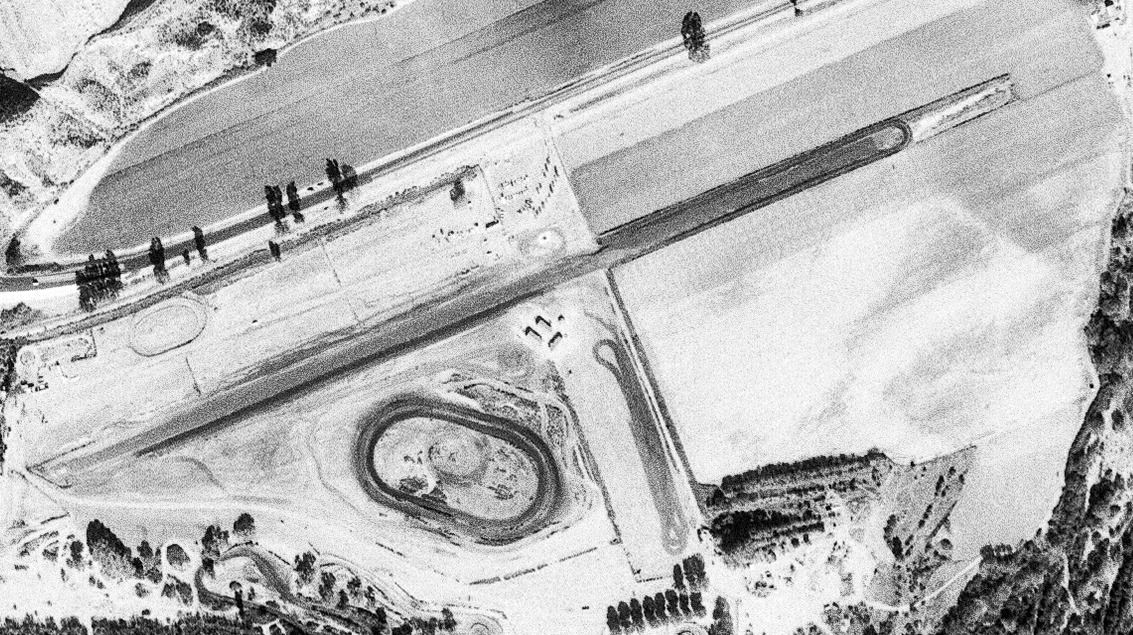
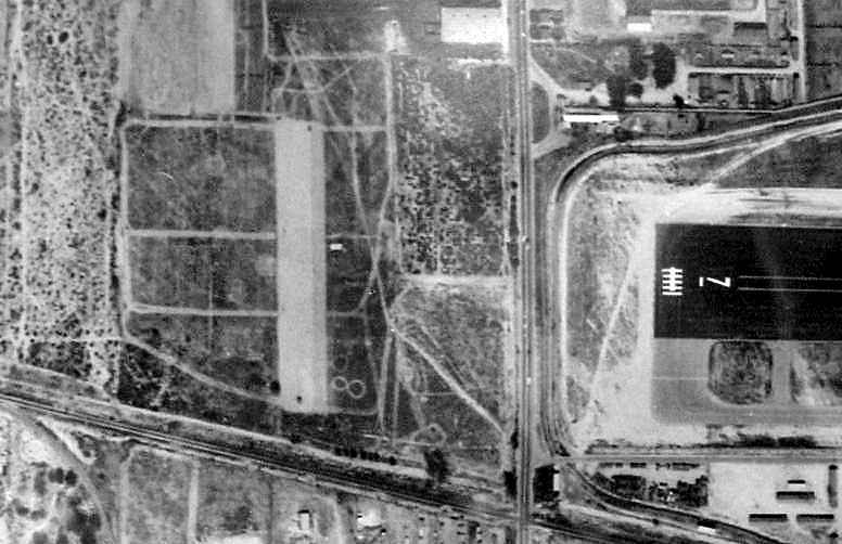
An 11/23/77 USGS aerial view depicted the single runway at Indian Dunes, along with the adjacent oval racetrack on the south side.
Bill Bazen recalled, “The TV series 'CHIPS' filmed an episode right on the [Indian Dunes] runway: episode 'Return of the Super Cycle' in 1979.”
The Indian Dunes airfield was not depicted on the July 1980 LA Terminal Aeronautical Chart (courtesy of Jim Hackman).
The 1982 AOPA Airport Directory (courtesy of Ed Dury) described Indian Dunes as a private airfield with a single 3,300' asphalt Runway 9/27.
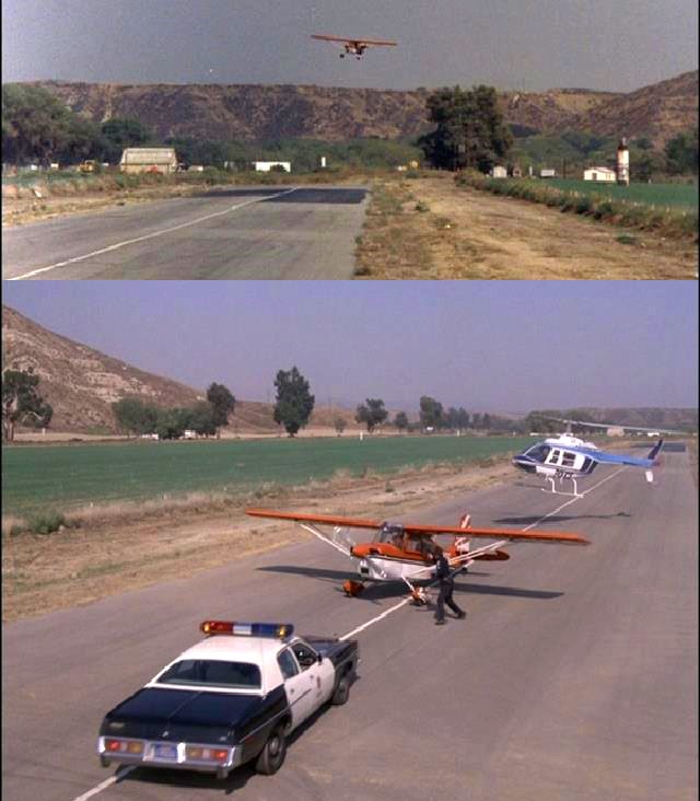
A pair of stills of a Citabria landing & then being surrounded by a police car & a Bell Jet Ranger on the Indian Dunes paved runway from the 1982 episode “A Cry For Help” of the TV series “TJ Hooker” (courtesy of Bill Bazen).
A still showing the Indian Dunes runway, hangar, and several light planes from the 1982 episode "Now You See It" of the TV series "The Greatest American Hero" (courtesy of Bill Bazen).
The adjacent Indian Dunes park was the scene of a tragic accident in 1982,
when actor Vic Morrow & two child actors were killed when a UH-1 Huey crashed on top of them
during filming of a scene for the Stephen Spielberg film, "Twilight Zone - The Movie".
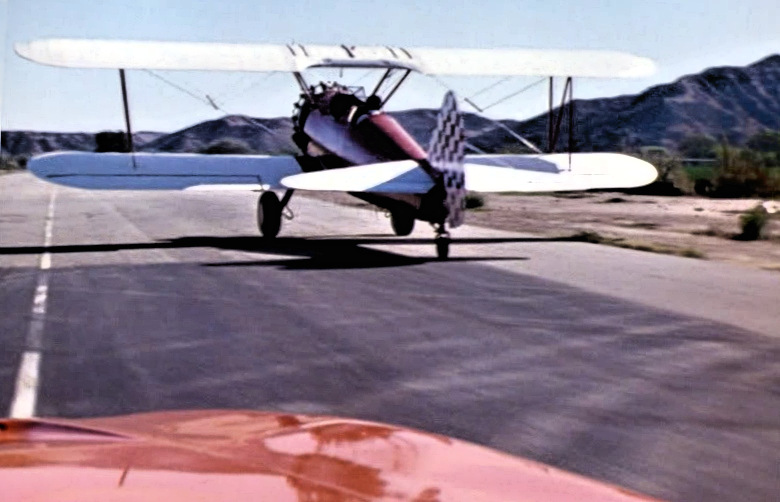
A still of a Stearman on the Indian Dunes runway from the 1983 episode “High Flyin Dukes” of the TV series “Dukes of Hazard” (courtesy of Bill Bazen).
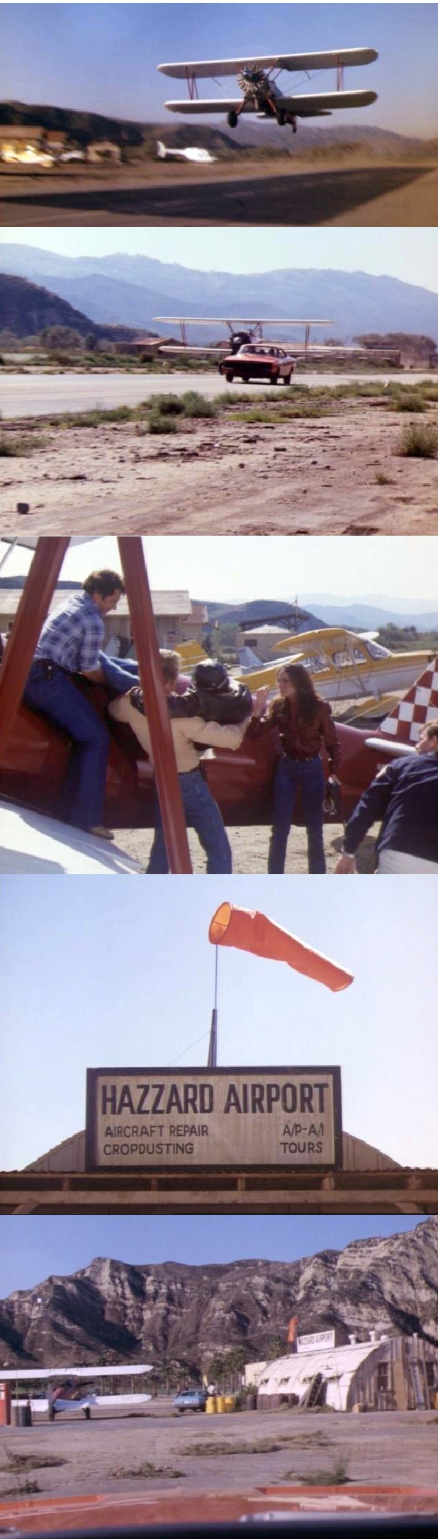
A series of stills of a Stearman chasing the “General Lee” on the Indian Dunes runway from the 1983 episode “High Flyin Dukes” of the TV series “Dukes of Hazard” (courtesy of Bill Bazen).
Funny that the producers of the show would think that anyone would think that the desert scenery & brown rocky mountains in the background would look like Georgia.
A pair of stills of an ultralights & a Beech 18 on the Indian Dunes runway from the 1983 episode “Holiday in the Hills” of the TV series “The A-Team” (courtesy of Bill Bazen).
Peter Albiez reported, “While I was doing the TV Series Blue Thunder [1984]
we used the airport & I landed my plane there for background use in the filming.”
Indian Dunes was also a filming site for many other movies & television programs,
including part of "Escape From New York", and "Some Kind Of Hero" with Richard Pryor.
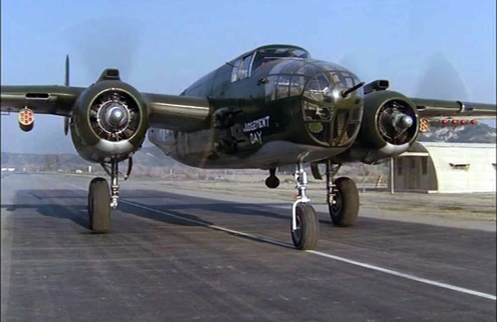
A still of a North American B-25J Mitchell “Judgment Day” (heavily loaded with prop ordnance) on the Indian Dunes runway from the 1985 episode “Dambreakers” of the TV series “Airwolf” (courtesy of Bill Bazen).
Jim Stoughton recalled, “I remember working at Indian Dunes airstrip. I did ground-to-air to communication & worked briefly for Tallmantz Aviation.
We did the in-flight filming of the pilot episode & a few others.”
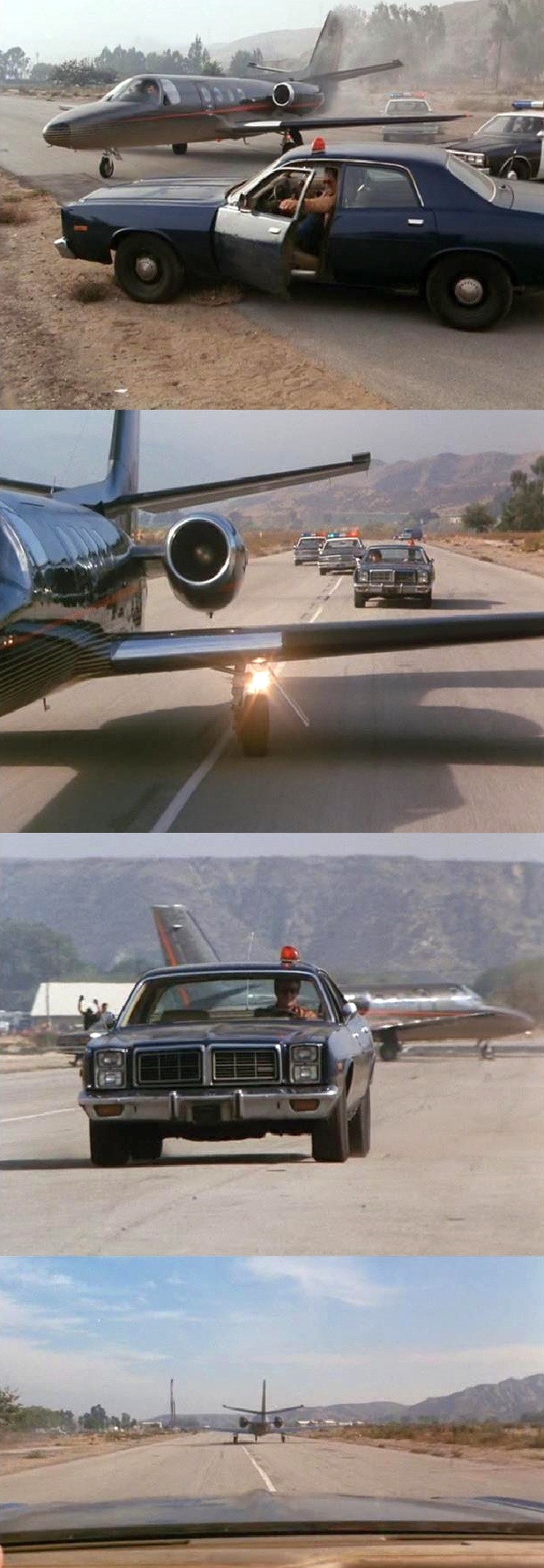
A series of stills of a Cessna Citation business jet being chased by police cars on the Indian Dunes runway from the 1986 episode “Warzone” of the TV series “Hunter” (courtesy of Bill Bazen).
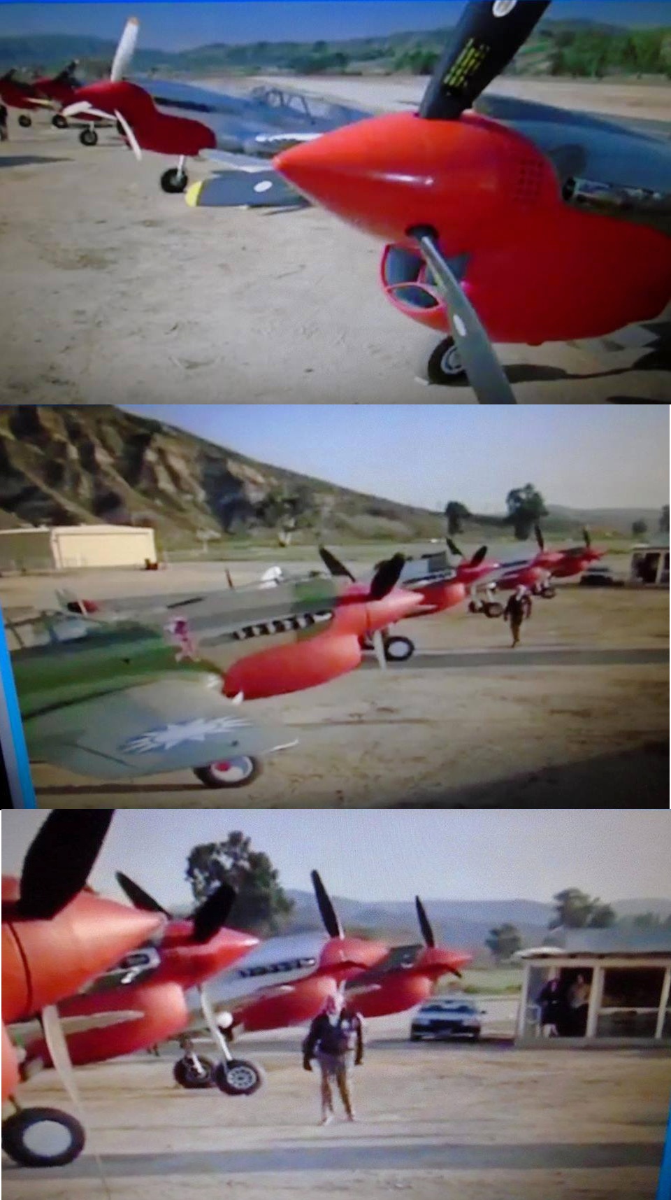
A series of stills of 4 Curtis P-40 Warhawk WW2 fighters at Indian Dunes from the 1986 episode “Steele Blue Yonder” of the TV series “Remington Steele” (courtesy of Bill Bazen).
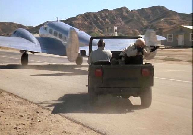
A stills of Beech 18 being chased by a jeep on the Indian Dunes runway from the 1986 episode “The Crystal Skull” of the TV series “The A-Team” (courtesy of Bill Bazen).
Herbert Cole recalled, Indian Dunes Airport "remained 'active' into the mid 1980s if I remember correctly.”
The last television production made at Indian Dunes was "China Beach" (1988-91).
Steve Hinton recalled, “I was involved with many movie projects at Indian Dunes... until Rocketeer in 1989.
The runway was torn up right before Rocketeer but the Bulldog Restaurant was built on the property anyway.
We did not do any flying then [at Indian Dunes]. The flying for Rocketeer was done in Santa Maria.”
A 5/29/86 aerial view (from the UCSB Library) showed the Indian Dunes paved runway.
The last film production made at Indian Dunes was "The Rocketeer" (1991).
Herbert Cole recalled, Indian Dunes Airport "I assume its demise was closely tied to the end of Indian Dunes as a race track,
and the urban sprawl encroaching from the east."
The 1991 USGS topo map depicted a single paved northeast/southwest runway, labeled simply “Landing Strip”,
with a single building north of the runway midpoint.
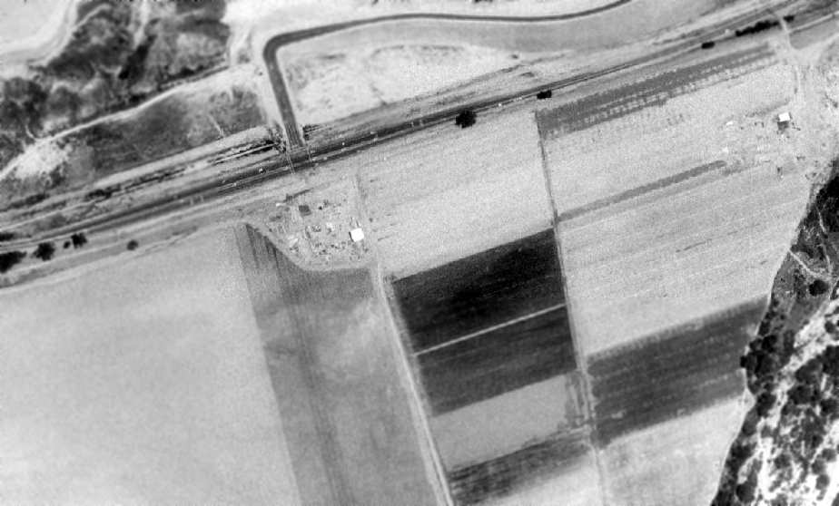
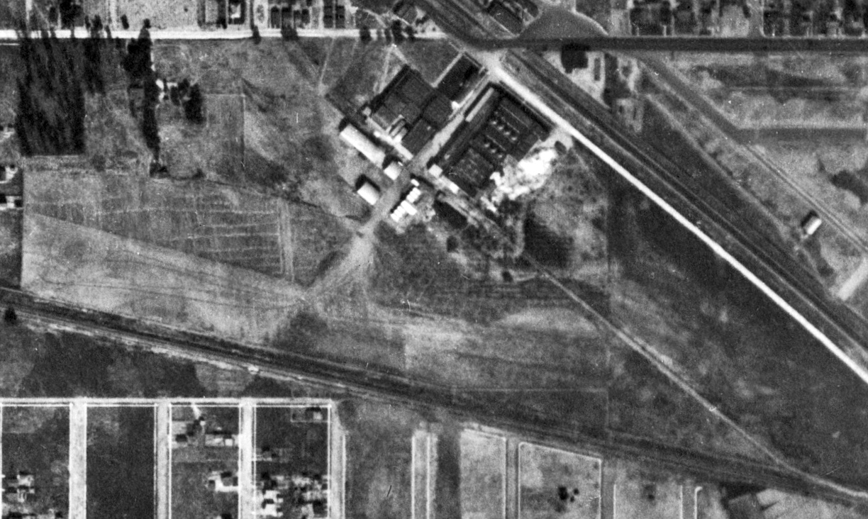
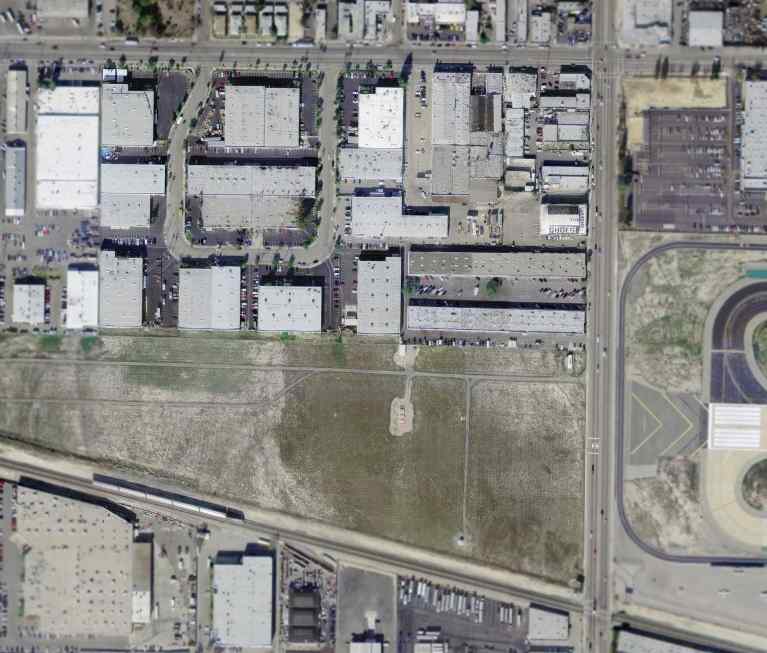
A 1994 USGS aerial view showed a section of Indian Dunes' eastern portion of the former runway was still discernible.
The remainder of the former runway had apparently been returned to farming.
A single hangar was visible in the center of the image,
while other (apparently non-airfield related) buildings were located at the east end of the former runway.
Indian Dunes is now owned by the Newhall Ranch Development Company.
They closed the area to movie & film production some time ago, and they have preliminary plans for thousands of houses for the property.
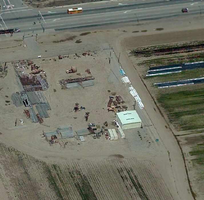
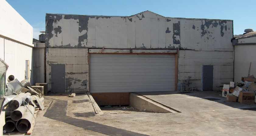
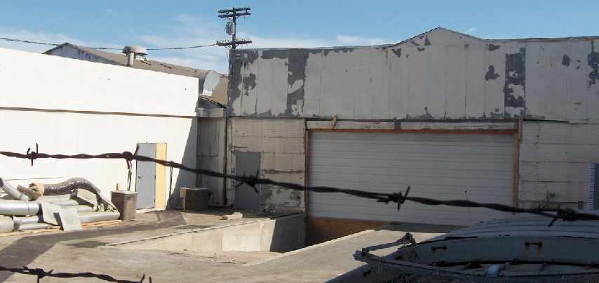
A 2004 photo by Jon Karkow of the single hangar at Indian Dunes.
Jon reported that the "hangar is near the intersection of Route 126 & Wolcott.
I also visited the buildings near the east end of the property, but these do not appear aviation related."
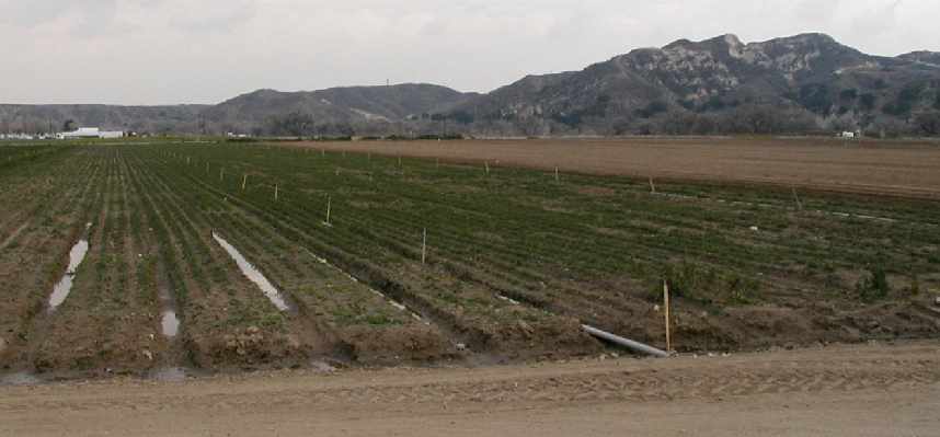
A 2004 photo by Jon Karkow, looking southeast from the hangar at the area of the former runway at Indian Dunes.
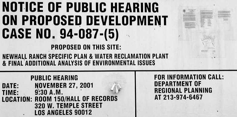
A 2004 photo by Jon Karkow of a notice describing proposed development at the site of the Indian Dunes Airfield.
Jon reported, the signs on the fence read "Newhall Land & Farming Company".
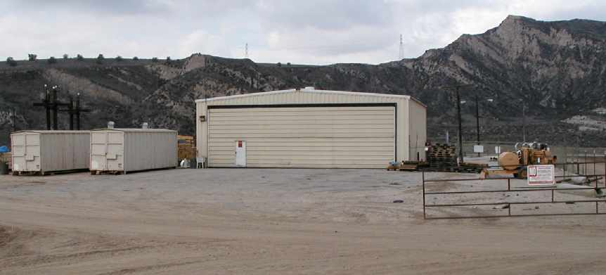
A circa 2005 aerial photo looking north at what appears to be a single hangar at Indian Dunes.
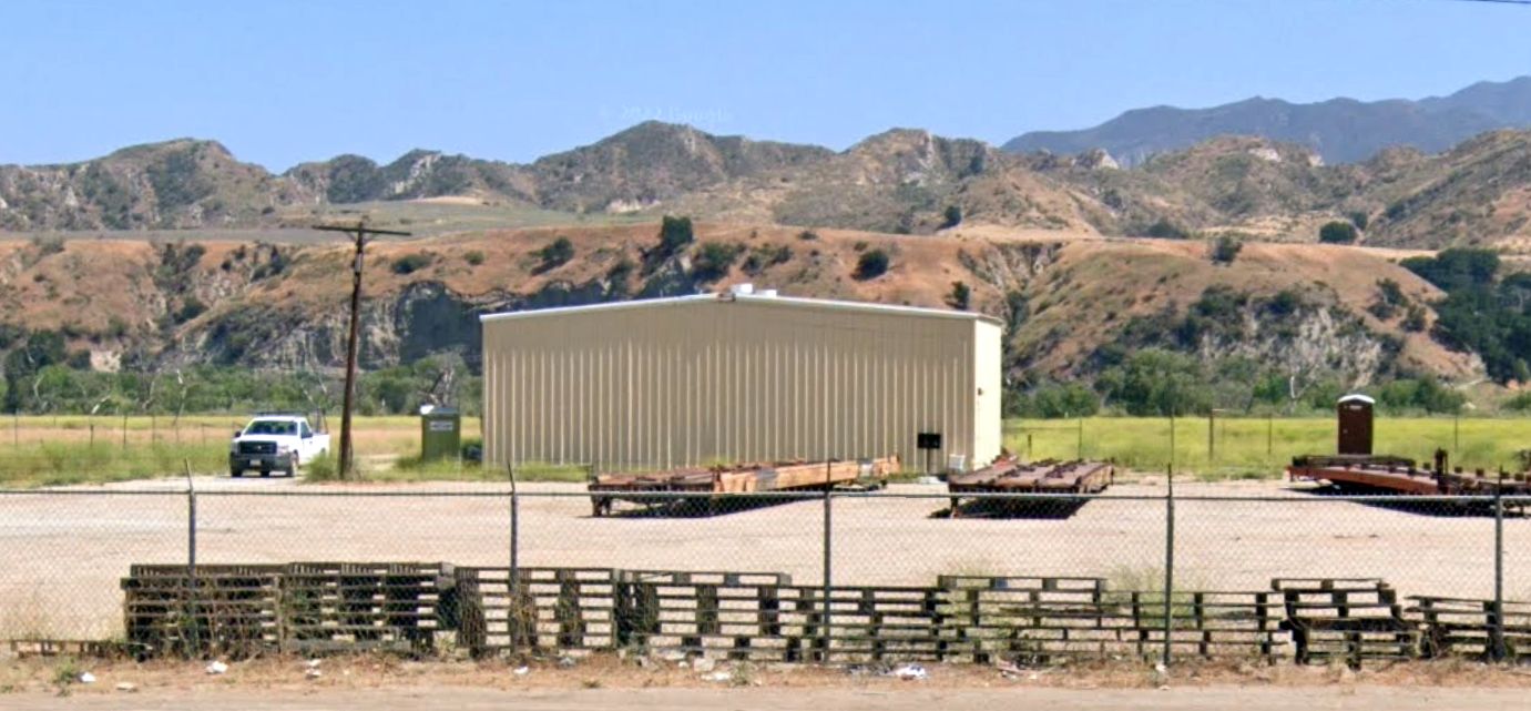
A 2022 photo looking south at the former hangar at Indian Dunes.
The site of Indian Dunes Airport is located south of the intersection of Route 126 & Wolcott Way.
Thanks to Mark Reynosa for pointing out this airfield.
____________________________________________________
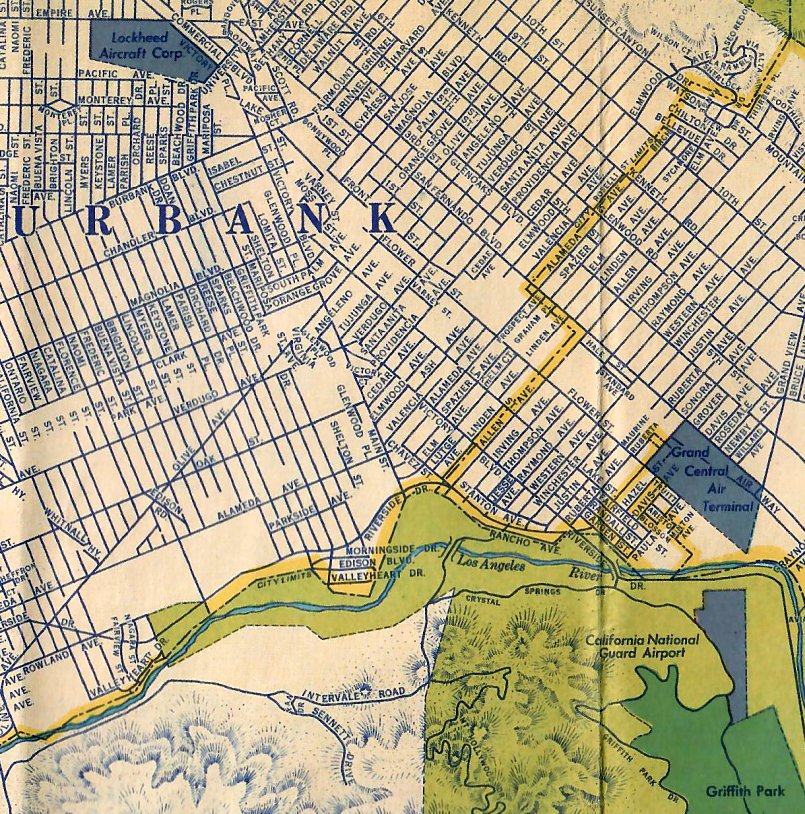
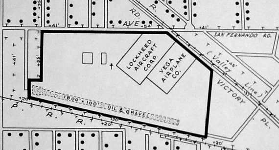
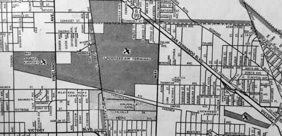
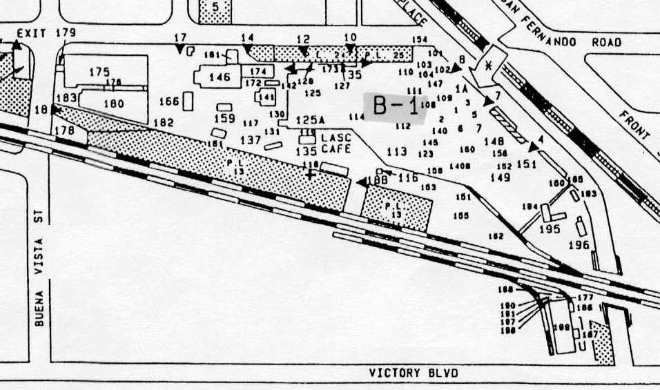
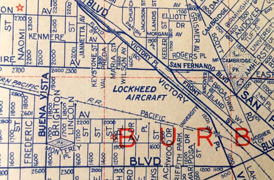
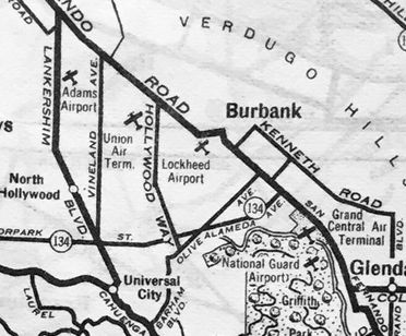
Lockheed Airport / Lockheed Aircraft Company Plant B-1 Airfield, Burbank, CA
34.19, -118.33 (Southeast of Burbank Airport, CA)
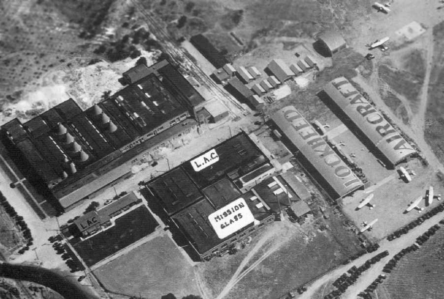
A 1928 aerial view (from the UCSB Library) of the airfield at the original Lockheed plant.
In 1928 the Lockheed Aircraft Company began operating at this location,
southeast of the intersection of North Buena Vista Street & West Empire Avenue.
It was not adjacent to the Burbank Airport, which was a half-mile to the northwest.
Building #1 was originally the Mission Glass factory, and Lockheed initially shared the building with Mission Glass before taking over the entire facility.
The earliest map depiction which has been located of the original Lockheed plant airfield was on a 1930 street map (courtesy of Kevin Walsh),
which depicted “Lockheed Airport” as a narrow property north of the railroad.
A 1930 aerial view of the airfield at the original Lockheed plant,
with its runway clearly visible on the south side of the factory buildings (courtesy of Mark Reynosa).
At some point between 1928-30, a single runway was constructed on the southern edge of the Plant B-1 property.
It was approximately 2,000' long, and ran northwest/southeast on the north side of the Southern Pacific Railroad tracks.
A 1930 aerial view of the buildings at the original Lockheed plant (courtesy of Dan MacPherson).
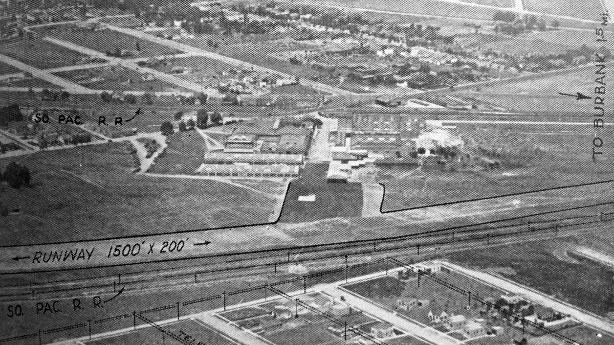
An undated aerial view looking north at “Lockheed Airport” from the Richfield Oil Company's 1930 California Airports directory (courtesy of Kathy Vaughn).
The directory described Lockheed as a private airfield having a 1,500' east/west sandy loam runway, and listed the Manager as Frank Crane.
An undated photo of Jimmy Doolittle in front of a Lockheed Orion,
with the original Lockheed hangars in the background (courtesy of Dan MacPherson).
The Lockheed runway was not depicted on the 1932 USGS topo map, nor on the 1932 LA Sectional Chart (or subsequent Sectional Charts).
The 1935 H.M. Gousha / Shell Oil LA map (courtesy of Michael Binder) depicted “Lockheed Aircraft Corp” as an irregularly-shaped property outline.
A 1938 Rand-McNally Texaco map (courtesy of Kevin Walsh) depicted “Lockheed Airport” as an irregularly-shaped property outline.
This facility produced the majority of Lockheed aircraft before WW2, including Vegas, Orions, Hudsons, and P-38s.
The plant was eventually designated Plant B-1, once Lockheed expanded to several other plants around the Burbank Airport area.
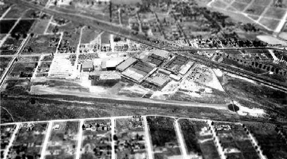
The layout of the airfield at the original Lockheed plant as of 1939 (courtesy of Mark Reynosa).
A 1939 aerial view looking south at Lockheed Plant B-1,
with the runway visible on the far side of the factory buildings (courtesy of Dan MacPherson).

The 1939 “Los Angeles County Airport Map” depicted “Lockheed” as having a single northwest/southeast runway.
A 1940 aerial view looking north at Lockheed Plant B-1,
with its runway clearly visible in front of the factory buildings (courtesy of Mark Reynosa).

The Lockheed Plant B-1 airfield as depicted on a 1940 street map (courtesy of Kevin Walsh).
The Lockheed Plant B-1 airfield was depicted as"Lockheed Airport" on a 1940 Shell street map (courtesy of Dan MacPherson).
According to Dan MacPherson, "The Lockheed factory airstrip was in use until about 1941, when the P-38 came out.
The P-38s were towed down Empire Street in the middle of the night to the newly acquired Burbank (Union) Air Terminal,
which was renamed 'Lockheed Air Terminal'".
The Lockheed factory buildings were depicted on the 1941 & 1942 USGS topo maps, but they did not depict any runway
(but it may have been intentionally omitted due to wartime security concerns).
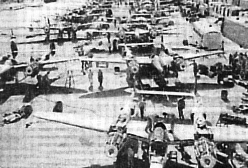
A WW2-era photo of P-38 Lightnings undergoing final assembly outdoors at Lockheed Plant B-1.
Lockheed took advantage of the sunny Southern California weather
by completing final assembly of many P-38s outdoors.
A total of 9,423 P-38 fighters & 500 F-4/F-5 reconnaissance versions were built at Plant B-1 during WW2.
The airstrip at Plant B-1 was reused as a parking lot during WW2, and was apparently never used again as a runway.
A circa 1945 street map (courtesy of Ken Brody) depicted the “Lockheed Airport” to the southeast of the “Lockheed Air Terminal”.
The last depiction which has been located of the Lockheed Plant B-1 Airfield was on a 1947 Rand-McNally street map (courtesy of Kevin Walsh), which labeled it as “Lockheed Airport”.
The Lockheed Plant B-1 airfield was not depicted at all on the 1947 LA Local Aeronautical Chart (courtesy of Tim Zukas).
By the time of the 1948 USGS topo map, Lockheed factory buildings had covered much of the northern portion of the Plant B-1 property.
A post-WW2 layout of Lockheed Plant B-1. The runway south of the factory had been reused by this point as a parking lot.
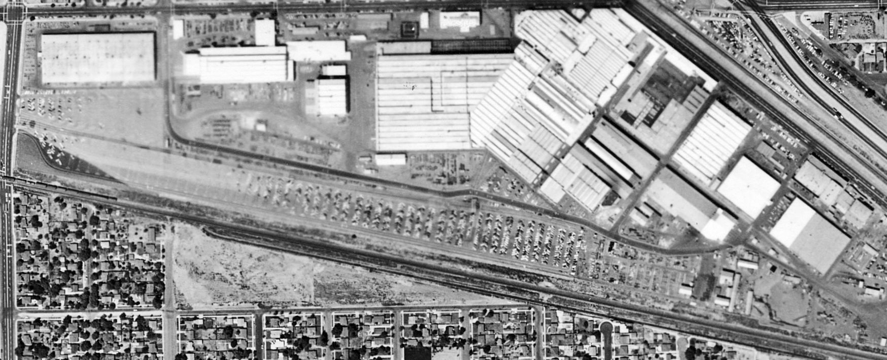
An 8/22/56 aerial photo (from the UCSB Library) showed that the Lockheed Plant B-1 runway had been reused as a factory parking lot.
A 1955 street atlas (courtesy of Kevin Walsh) depicted “Lockheed Aircraft”, but no longer depicted an airfield.
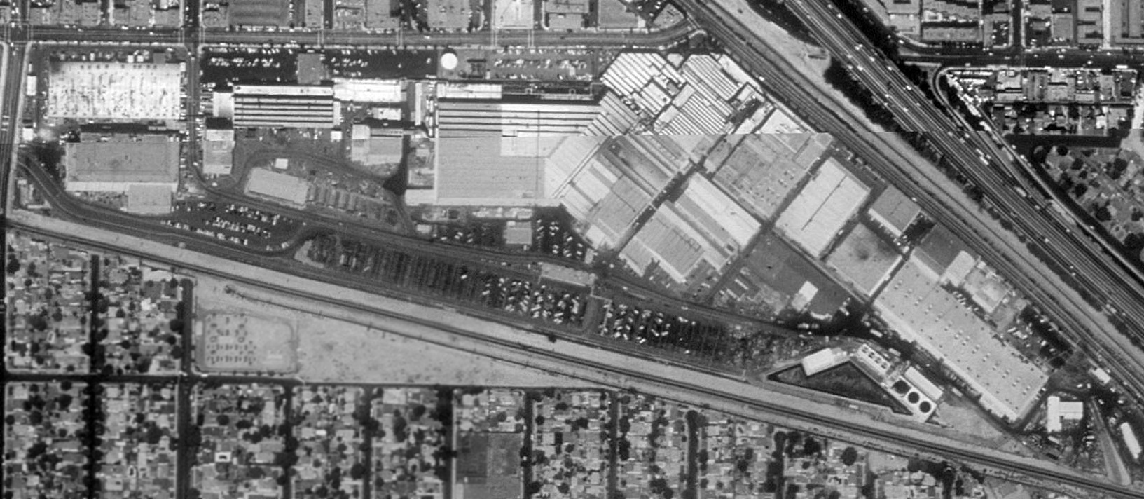
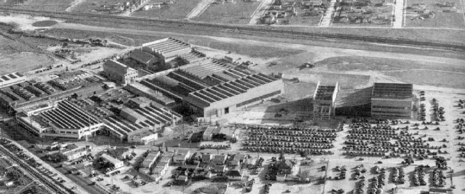
A 1989 USGS aerial view of Lockheed Plant B-1, with the runway having been reused as a factory parking lot.
Lockheed Plant B-1 was closed in 1991.
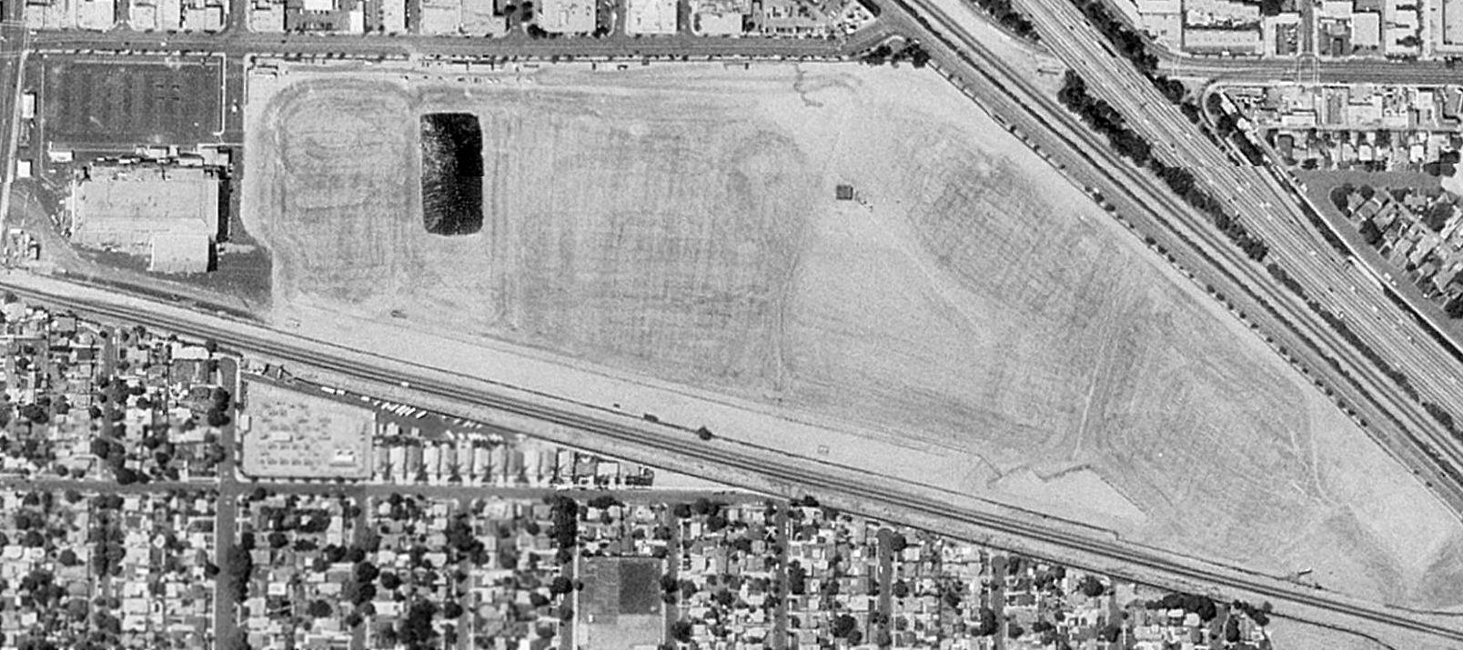
The 1994 USGS aerial photo depicted that the entire Lockheed Plant B-1 facility had been razed, with the site completely empty & flat.
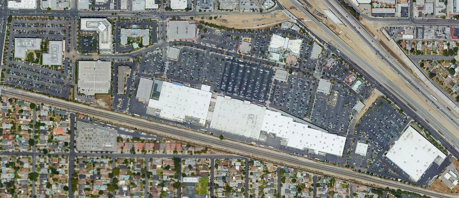
A 2017 USGS aerial view showed a shopping center has been constructed on the site of the former Lockheed Plant B-1,
and not a trace remains of the extensive & historic industrial facilities or airfield.
More American aviation manufacturing infrastructure replaced by retail shopping. An unsustainable trend.
____________________________________________________
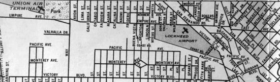
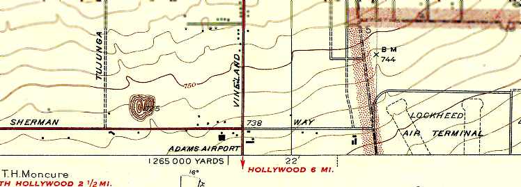
Wilson Airport / North Hollywood Airport, Burbank, CA
34.203, -118.365 (West of Burbank Airport, CA)
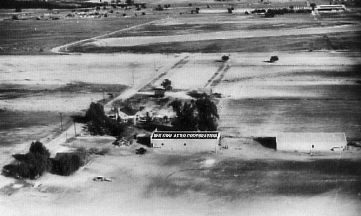
An undated view of Wilson Airport (from "The Motion Picture Stunt Pilots" by Hugh Wynne, courtesy of Dan MacPherson).
The runway of the "Union Air Terminal" (the present-day Burbank Airport) is in the background.
According to material contributed by Dan MacPherson,
Wilson Airport was one of 2 tiny airports (the other was Adams Port) which were located
adjacent to the west side of what is the present-day Burbank Airport.
Wilson Airport was located adjacent to the west side of Burbank's NW/SE runway (which no longer exists).
The date of construction of Wilson Airport has not been determined.
The earliest reference which has been located to Wilson Airport
was the Standard Oil Company's 1929 "Airplane Landing Fields of the Pacific West" (courtesy of Chris Kennedy).
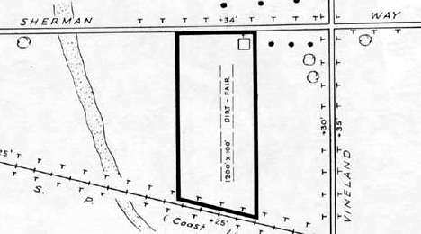
It described Wilson Airport as having a 2,600' oiled north/south runway, with 2 hangars on the northeast side.
Wilson Airport was operated by Roy & Tave Wilson.
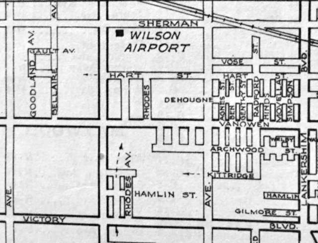
Wilson Airport, as depicted on a 1930 street map (courtesy of Kevin Walsh).
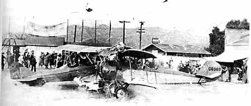
An undated photo from "The Motion Picture Stunt Pilots" by Hugh Wynne (courtesy of Dan MacPherson) depicting a crash scene of 2 biplanes at Wilson Airport.
The plane at right appears to be NC6369, Alexander Eaglerock A-2 687.
Wilson Airport's Hangar #1 is visible at the extreme right of the photo (see the entry describing Adams Port for a set of photos depicting the same hangar in 2004).
Wilson Airport was not depicted on the 1932 USGS topo map or the June 1932 LA Sectional Chart.
Wilson Airport may have been also (briefly) known as North Hollywood Airport,
as that is how it was labeled on the August 1933 LA Sectional Chart.
The last aeronautical chart depiction which has been located of North Hollywood Airport was on the July 1935 LA Sectional Chart.
North Hollywood Airport was no longer depicted on the December 1935 LA Sectional Chart.
The 1936 Civil Aeronautics Administration Airport Directory described Wilson as a private airport,
located "1,100 feet west of Union Air Terminal" (the present-day Burbank Airport).
The airfield consisted of a single 1,900' gravel runway.
Hangars were located on the east side of the airfield, one of which had "Wilson Aero Corporation" painted on the roof.
Wilson Airport was used by Hollywood stunt pilots.
The 1936 directory included the note, "Anyone using the field should be careful at all times
as motion picture sets are located on landing strip at different times."
According to Dan MacPherson, "Wilson closed about 1937.
Burbank extended the east/west runway & the Wilson property was cleared.
The hangars were picked up, and moved to Adams Port,
where they were placed side by side & eventually converted to one structure by removing the common wall.
It was cost effective then to save used buildings. Nowadays they just tear them down."
Wilson Airport was no longer listed in airport directories from 1937, 1938, or 1944,
nor depicted on a 1939 LA County Airports Map,
and there was no obvious trace of the airfield on a 1954 aerial photo.
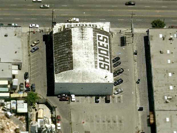
As seen in the March 2004 USGS aerial photo, not a trace appears to remain at the site of the former Wilson Airport
(although present-day Burbank Airport is just across the street).
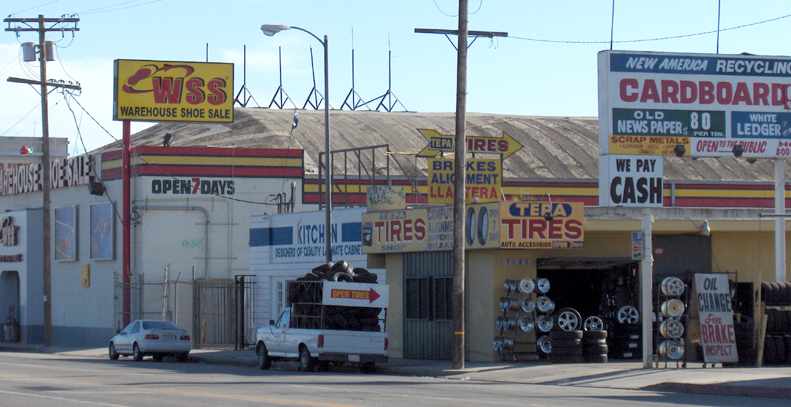
The site of Wilson Airport is located southeast of the intersection of Sherman Way & Vineland Avenue.
____________________________________________________
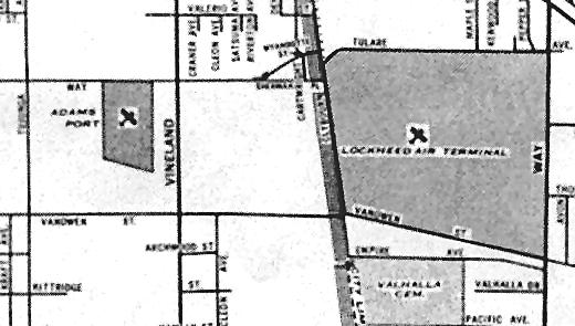
Bob Lloyd Airport / Adams Port / Adams Airport, North Hollywood, CA
34.2, -118.373 (West of Burbank Airport, CA)
Adams-Port, as depicted on the December 1935 LA Sectional Chart.
According to Dan MacPherson, this was one of 2 tiny airports (the other was Wilson Airport)
which were located adjacent to the west side of what is the present-day Burbank Airport.
The field was originally known as Bob Lloyd Airport (Bob Lloyd was a movie pilot).
According to Don Ayers, "Prior to use as a hangar & active airport,
the building had been used to stage boxing fights in the late 1920s - early 1930s."
The date of establishment of Bob Lloyd Field has not been determined.
An advertisement dated 9/31 (courtesy of Dan MacPherson) was entitled "New Owners Take Over Bob Lloyd Airport."
It read, "The Bob Lloyd Airport in North Hollywood has been purchased by C.J. Westfall & J.J. Adams,
who will continue to operate the field as a base for school operations.
Adams will be flight instructor & Westfall ground school instructor.
The new owners have purchased a Great Lakes for training. At this point, the field became known as Adams Port.
Adams-Port was not yet depicted on the July 1935 LA Sectional Chart.
The earliest depiction which has been located of Adams-Port was on the December 1935 LA Sectional Chart.
It depicted Adams-Port as an auxiliary airfield.
The earliest directory reference to Adams Port which has been located is a 1936 Civil Aeronautics Administration Airport Directory.
It described Adams Port as a private field, located "1,000' west of Union Air Terminal" (the present-day Burbank Airport).
The airfield consisted of a single 1,900' gravel runway.
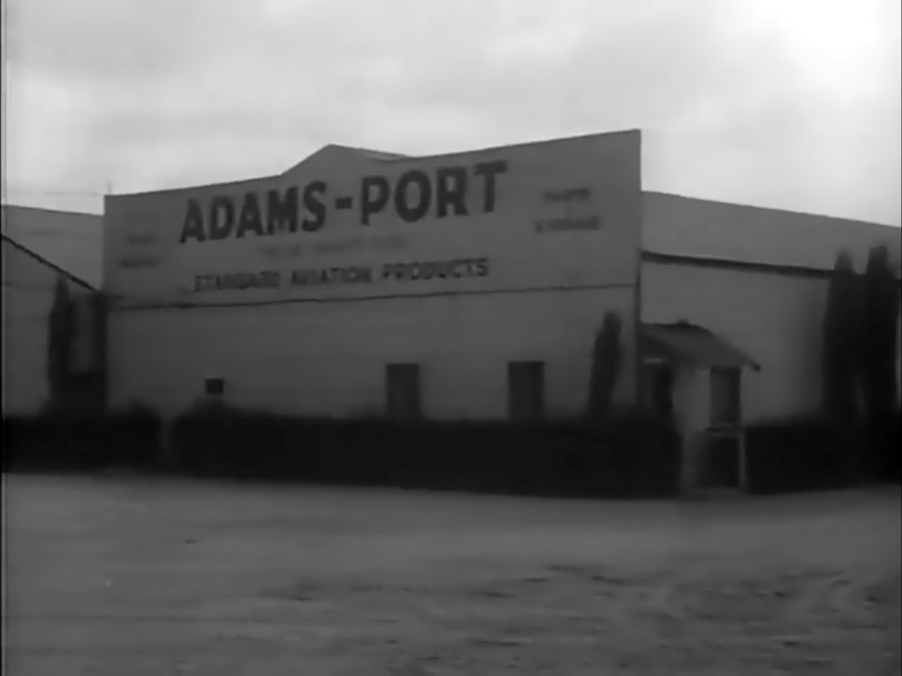
Hangars were located on the east side of the airfield, one of which had "Adams-Port" painted on the roof.
According to Dan MacPherson, when nearby Wilson Airport was closed in 1937,
its "hangars were picked up, and moved to Adams Port,
where they were placed side by side & eventually converted to one structure by removing the common wall.
So the hangars have been at both airports. It was cost effective then to save used buildings. Nowadays they just tear them down."
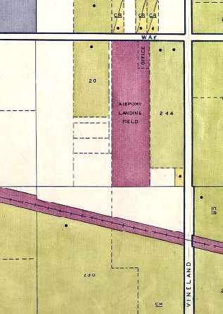
A circa late-1930s WPA map (courtesy of Harry Marnell) depicted Adams Port
as a narrow north/south lot labeled “Airport Landing Field”, with an office at the northeast corner.
Adams Airport, as depicted on a 1938 map (courtesy of Kevin Walsh).
Adams Port was listed in a 1938 Airport Directory (according to Dan MacPherson).
The layout of Adams Port as depicted on a 1939 map (courtesy of Mark Reynosa).
The 1939 “Los Angeles County Airport Map” depicted “Adams” as having a single north/south runway.
Don Ayers recalled, "I came to California in 1940 at age 12; the first airport I visited here was 'Adams' Airport.
When I visited it, the name was painted on the roof.
The hangar could hold 6 planes on the wheels as stated in Application,
however on 12/7/41 the Airport was 'Closed to all Flying',
so the private owners allowed their planes to be stacked on the noses;
20-23 were in the hangar for the duration, or till hauled away.
Before December 7th I toured the hangar several times.
'Wrong Way' Corrigan's plane was in the left back corner on the wheels in flyable condition.
The biplane used for instruction was on wheels & flyable in the right-back corner.
Parked just inside the door center was Edgar Bergen's Stinson Station Wagon (nice).
The rest of the hangar had several small planes of various types, like Piper Cubs, etc."
An undated street map (courtesy of Dan MacPherson),
showing the location of Adams Port relative to the "Lockheed Air Terminal" (the present-day Burbank Airport).
The 1942 USGS topo map depicted Adams Airport as having a few small buildings along the north side, on the south side of Sherman Way.
The only photos which have been located showing Adams Port while in operation were stills from the movie “Gmen Vs. the Black Dragon” which was evidently shot at Adams Port in 1942.
This image (courtesy of Thomas Pollack) shows the hangar labeled “Adams-Port”.
The only photos which have been located showing Adams Port while in operation were stills from the movie “Gmen Vs. the Black Dragon” which was evidently shot at Adams Port in 1942.
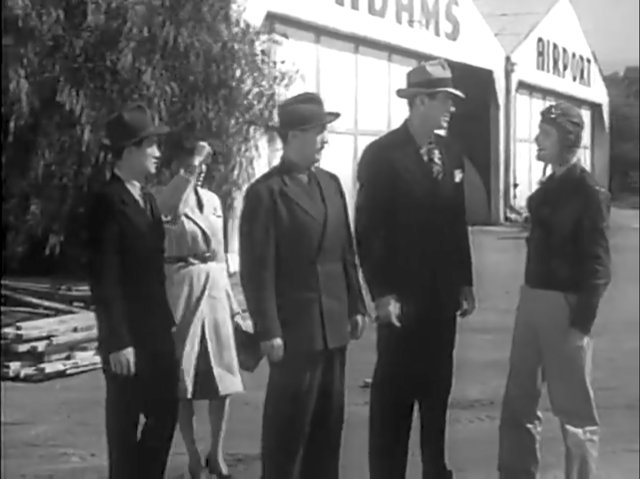
This image (courtesy of Thomas Pollack) shows 2 hangars labeled “Adams Airport”.
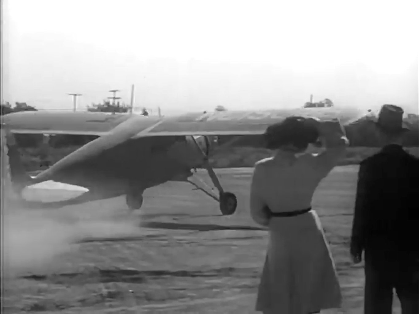
The only photos which have been located showing Adams Port while in operation were stills from the movie “Gmen Vs. the Black Dragon” which was evidently shot at Adams Port in 1942.
This image (courtesy of Thomas Pollack) shows NC15346, a 1935 Fairchild 24.
The last aeronautical chart depiction which has been located of Adams Port was on the February 1944 LA Sectional Chart.
It depicted Adams Port as an auxiliary airfield.
Adams Airport was evidently closed at some point in 1944,
as it was no longer listed in a 1944 airport directory, nor depicted on the March 1945 LA Sectional Chart.
Adams Port, as depicted on a circa 1945 street map (courtesy of Ken Brody).
The last depiction which has been located of Adams Airport was on a 1947 Rand-McNally street map (courtesy of Kevin Walsh).
Adams Airport was not depicted at all on the 1947 LA Local Aeronautical Chart (courtesy of Tim Zukas)
nor on the 1949 USGS topo map.
The Adams Port property had not yet been redeveloped as of a 1950 aerial photo (courtesy of Mark Reynosa),
but it also was not apparent from that photo whether the airfield was still in operation.
A 1954 aerial view showed that the north/south runway remains had been removed at some point between 1950-54.
A 1972 aerial view showed that buildings had been built
at some point between 1954-72 over the northern half of the site of Adams Port.
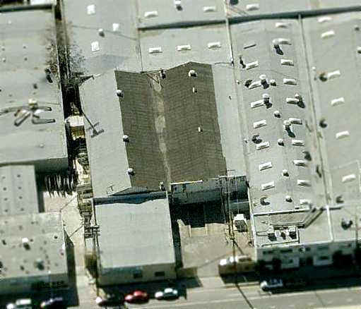
The March 2004 USGS aerial photo shows that the site has been redeveloped with numerous buildings.
Although the site was no longer recognizable from above as a former airport,
closer inspection will reveal that the former hangars were still standing.
Several former hangars from Wilson Airport & Adams Port were recently 'rediscovered'.
According to Dan MacPherson, "The discovery of the hangars, much leg work,
and much background information comes from Ron Dickson,
and his fledgling "Burbank Aviation Museum" which is currently looking for a home."
A 2004 photo by Rob Dickson (courtesy of Dan MacPherson) of the front of the former Hangar #1,
"recognizable by peak of the roof extending above the sheetmetal façade."
This hangar was originally used at both Wilson Airport & Adams Port.
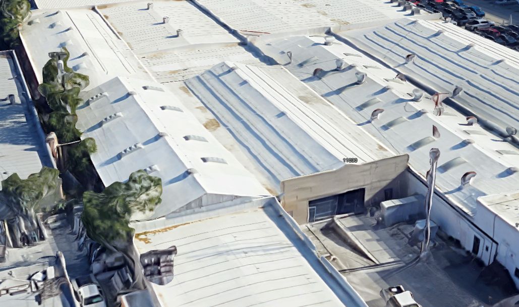
"The building is at 11034 Sherman Way, and is part of the 'Columbia Showcase' cabinet company."
A 2004 photo by Rob Dickson (courtesy of Dan MacPherson) of 2 of the remaining hangars originally from Wilson Airport & Adams Port.
Hangar #1 is on the right, "recognizable by peak of the roof extending above the sheetmetal façade",
and "Hangar #2 is to the left of it, nearly obscured by the other building."
A 2004 photo by Rob Dickson (courtesy of Dan MacPherson) of another of the remaining hangars at the site of Adams Port.
A circa 2006 aerial view looking east at the former Adams hangar which remains along Vineland Avenue.
A circa 2006 aerial view looking south at the former Adams hangars #1 & #2 which remain along Sherman Way.
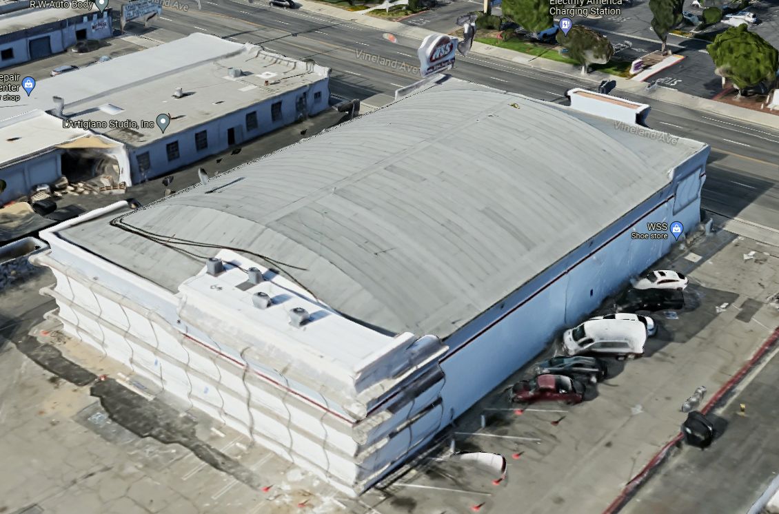
A 2023 3-D aerial image looking northeast at the former Adams hangar which remains along Vineland Avenue.
A 2023 3-D aerial image looking south at the former Adams hangars #1 & #2 which remain along Sherman Way, nearly subsumed by more-recent buildings.
The site of Adams Port is located southwest of the intersection of Sherman Way & Vineland Avenue.
____________________________________________________
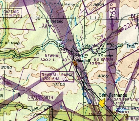
6-S Ranch Airpark, Santa Clarita, CA
34.42, -118.473 (Northwest of Burbank, CA)
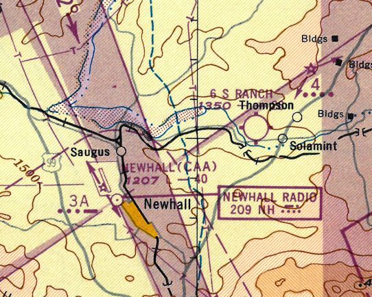
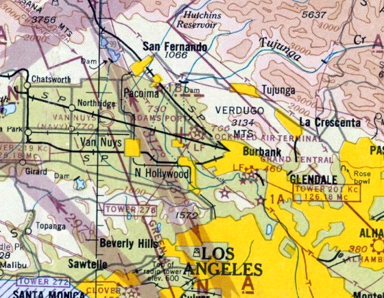
The "6 S Ranch" Airpark, as depicted on the 1947 LA Local Aeronautical Chart (courtesy of Tim Zukas).
Helm & Earle Schmidt opened an airport in 1946 on the 1,800-acre 6-S Ranch,
which had previously been owned by pioneer Los Angeles freighter Remi Nadeau.
6-S Ranch Airpark was not yet depicted on the February 1947 LA Sectional Chart.
The earliest depiction of the 6-S Ranch Airpark which has been located
was on the 1947 LA Local Aeronautical Chart (courtesy of Tim Zukas).
John Underwood recalled, “6-S Ranch... I have a few pictures of oddball airplanes that were kept there.
One day Helm Schmidt gave me a tour of his barn which contained a collection of interesting airplanes & the oldest Link trainer I’d ever seen.”
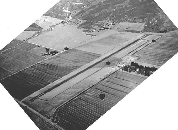
The earliest photo which has been located of the 6-S Ranch Airport was an 8/16/47 USGS aerial view (from the UCSB Library).
It depicted 6-S Ranch Airpark as having a single asphalt east/west runway,
with a hangar & over 20 light aircraft on the south side of the field.
The March 1948 LA Local Aeronautical Chart (courtesy of Chris Kennedy)
depicted 6-S Ranch Airpark as having a 2,600' unpaved runway.
A 1952 aerial view depicted 6-S Ranch Airpark as having a single asphalt east/west runway with a parallel taxiway.
A hangar was located on the south side of the field, to the west of which were visible 4 light aircraft.
An undated aerial view looking northeast at the 6-S Ranch Airpark (courtesy of Rick Jackson)
depicted a paved runway along with a parallel taxiway & a ramp.
6-S Ranch Airpark was not yet depicted at all on the 1955 USGS topo map.
Bob Cannon recalled, "6S Ranch in Saugus was also used as a drag strip
and on one trip in my 1932 roadster I broke a U-joint
and my Dad had to come out in the trusty 1941 Chevy truck & tow me all the way back to Alhambra."
A 1959 aerial view showed the runway & hangar remained intact.
But there were no aircraft visible on the field, instead there were a few dozen cars on the ramp.
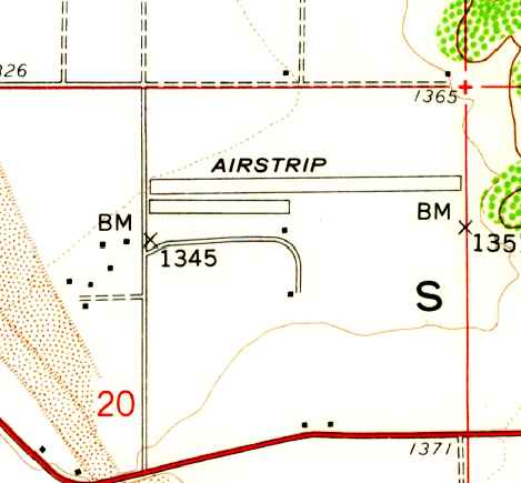
The 1960 USGS topo map depicted 6-S Ranch Airfield as a single paved east/west runway (labeled simply as “Airstrip”),
with a paved parallel taxiway or ramp on the southwest side, and a single small building on the south side.
The last aeronautical chart depiction which has been located of the 6S Ranch Airpark was on the March 1960 LA Sectional Chart.
It depicted 6S Ranch as having a 2,500' unpaved runway.
Following Helm Schmidt's death in 1960, the acreage of the 6-S Ranch Airpark was sold & developed into the North Oaks tract, which began construction in 1961.
It was the Santa Clarita Valley's second housing tract.
6-S Ranch Airpark was no longer depicted on the March 1961 LA Sectional Chart.
Jack Long Jr. recalled, "My late father was a pilot & lived since 1961 (strangely enough)
in the housing tract that replaced the Saugus CA 6-S Ranch Airfield.
As a child growing up in the area I remember climbing the hill north of the area to the abandoned light tower.
What memories."
The 1964 USGS topo map continued to depict the 6-S Ranch Airfield in the same fashion as depicted on the 1960 topo map.
A 1969 aerial view showed the site covered with houses, with not a trace remaining of the former airfield.
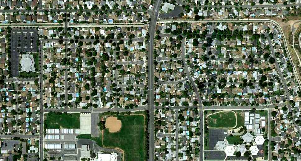
A 6/16/11 aerial photo shows not a trace remains of 6-S Ranch Airport.
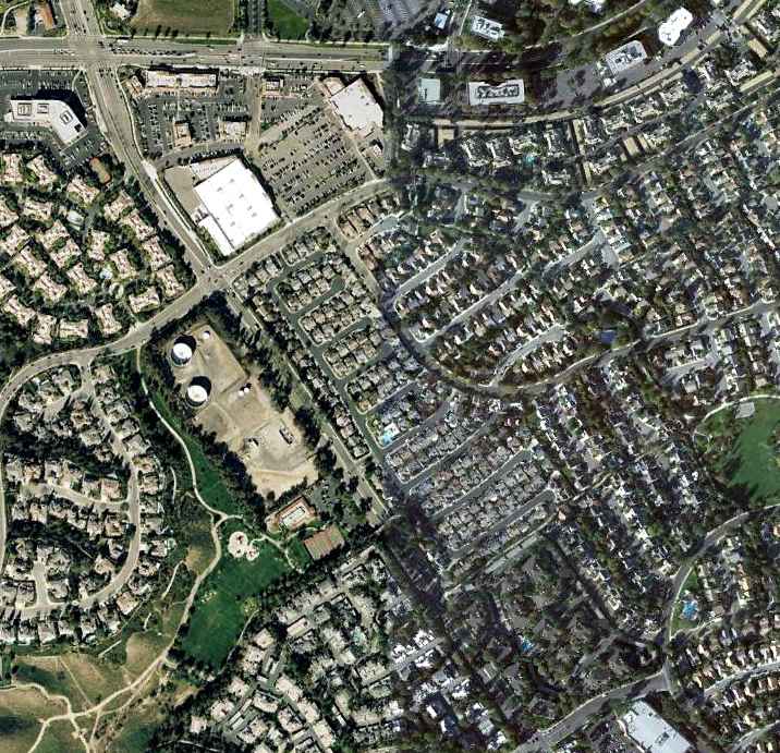
6-S Ranch Airfield sat to the north of the modern-day intersection of Pleasantdale Street & Whites Canyon Roads.
Thanks to Rick Jackson for pointing out the 6-S Ranch Airpark & clarifying its location.
See also: http://www.scvhistory.com/scvhistory/ap2406.htm
____________________________________________________
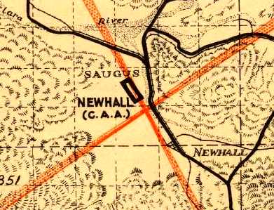
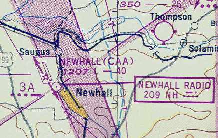
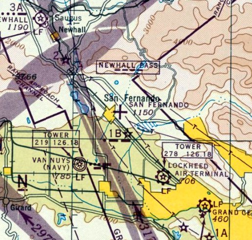
Saugus Intermediate Field / Newhall Airport, Newhall, CA
34.4, -118.55 (Northwest of Burbank, CA)
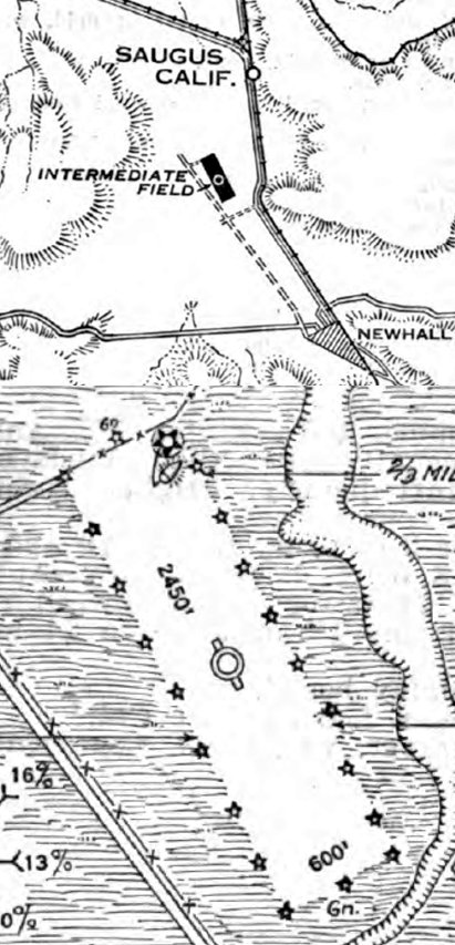
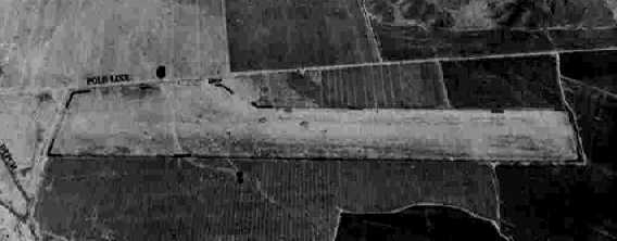
Saugus Intermediate Field, as depicted on the 3/18/29 Airway Bulletin #583 (courtesy of Lee Corbin).
The date of construction of this early airport is unknown.
The earliest reference which has been located of Saugus Intermediate Field was in the 3/18/29 Airway Bulletin #583 (courtesy of Lee Corbin).
It described Saugus as being Site 3A along the LA – San Francisco Airway,
and consisting of a 2,450' sod airfield, measuring 34 acres.
The Standard Oil Company's 1929 "Airplane Landing Fields of the Pacific West" (courtesy of Chris Kennedy)
described Saugus Intermediate Field as being operated by the Department of Commerce.
It was described as having a 2,600' north/south runway, with the surface simply described as "smooth"
(but it was obviously unpaved, as it also said "Landings or takeoff difficult or impossible in very wet weather").
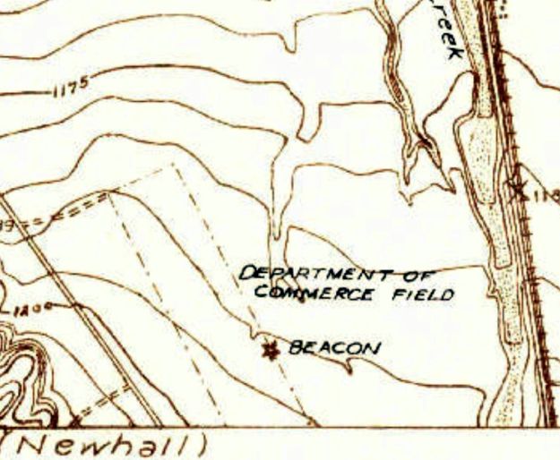
The earliest topo map depiction which has been located of Saugus Intermediate Field was on the 1929 USGS topo map (courtesy of Kevin Walsh).
It depicted a single northwest/southeast unpaved runway, labeled "Department of Commerce Field", along with a beacon along the east side of the field.
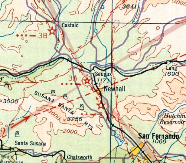
The earliest aeronautical chart depiction which has been located of Saugus/Newhall Field was on the June 1932 LA Sectional Chart.
It depicted Saugus as being Site 3A along the LA – San Francisco Airway.
The 1933 USGS topo map depicted the Saugus "Department of Commerce Landing Field" as northwest/southeast rectangular outline
with an "Airway Beacon" along the east side of the field.
The Airport Directory Company's 1937 Airports Directory (courtesy of Bob Rambo)
listed the airfield as "Site 3A", a Department of Commerce Intermediate Field along the LA-San Francisco Airway.
It was described as consisting of a 2,740' x 400' sod landing area.
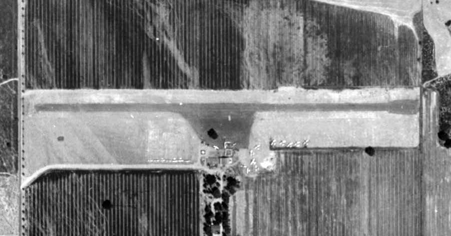
The earliest photo which has been located of Newhall Airport was a 12/5/38 USGS aerial photo (from the UCSB Library).
It depicted Newhall as having a single unpaved northwest/southeast runway, with a few small buildings on the southwest side.
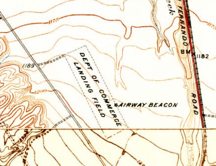
The 1939 USGS topo map depicted the "Department of Commerce Landing Field" as being oriented northwest/southeast,
with an "Airway Beacon" midway along the east side of the field.
Newhall Airport, as depicted on the 1939 LA Sectional Chart (courtesy of Jon Karkow).
In 1939, Newhall Airport was described as becoming a busy place twice a year, in spring & fall,
when airports to the south in the LA basin were fogged in.
Transcontinental airliners of American, United, TWA, and Western Air Express operated from Newhall.
A radio beacon was installed on the Newhall Pass in 1939,
but only a few of the transports which served the field were equipped to make use of its vertical beam.
The 1939 “Los Angeles County Airport Map” depicted “Newhall (C.A.A.)”, along with the adjacent 4-way radio range.
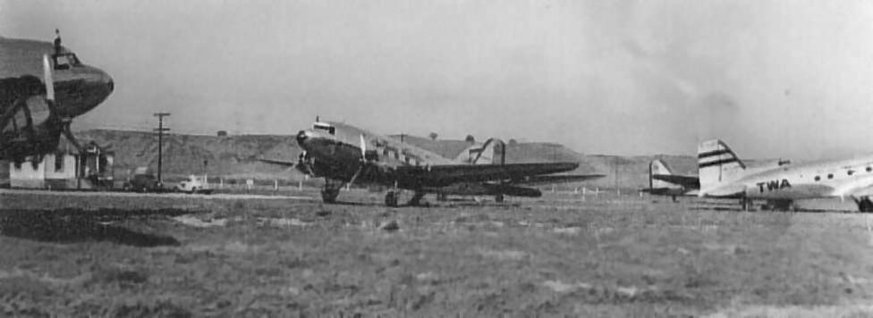
A 10/3/40 photo by Harold Gibson's father of no less than 5 DC-3 airliners on the ground at Newhall Airport (courtesy of Harold Gibson).
According to Bob Goubitz, “Notes indicate there were 8 aircraft on the field at that time.
They would bus the passengers from here to the valley or LA basin if that was fogged in.”
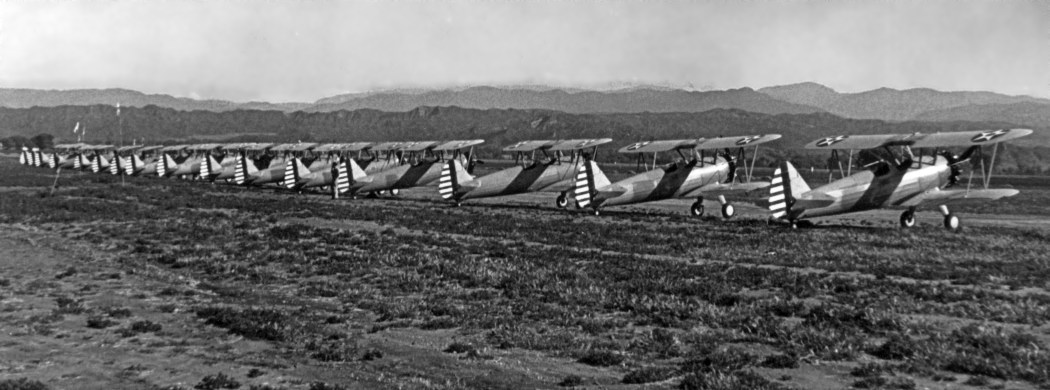
A 1941 photo of a long line of Stearman PT-13Bs at “Newhall Auxiliary Field” (courtesy of Patrick Fruedenthal).
Patrick Frudenthal remarked, “My uncle was a cadet at Cal-Aero in 1941, [and] appears to have done some training at Newhall.”

A 1941 photo of a Smith Bluebird glider participating in a contest at Newhall Airport.
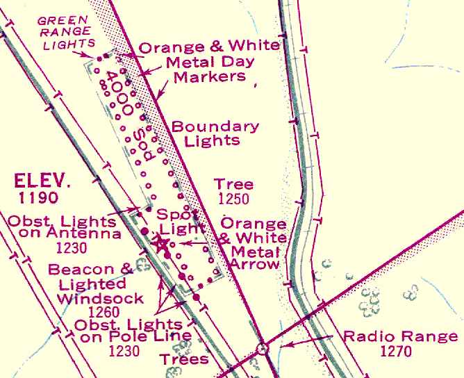
According to Russ Magowan Jr., “The Newhall Intermediate Field had a powerful rotating airway beacon on a steel tower with 2 large green lights.
A diesel motor generator shed contained standby power in case of power failure.
The communication station, manned 24 hours a day in three 8-hour shifts, was located close to the intersection of Newhall Avenue & 16th Street.
The runway, which ran north-south, was made of compacted gravel & was 3,000' in length.
During the war years, the Newhall station was very busy with 3 teletype circuits & 6 receivers for military & commercial aircraft to call the station.
It was not uncommon for there to be 400-500 contacts with aircraft above the station on a daily basis, 7 days a week.
The station also compiled an hourly weather report, which was placed on the weather teletype circuit.”
Russ continued, “Los Angeles International Airport was nonexistent as a field for commercial aircraft at this time.
For this reason, Newhall was even more important, as this station was near to Lockheed-Burbank,
which for all practical purposes was the main airport for Los Angeles passengers on commercial flights.
Should Burbank fog in, which it frequently did in the morning,
all scheduled flights landed at Newhall with the aid of the lone airways communication operator who was on duty.
The operators were Russ Magowan (Sr.), Bob Wilke, Norm Kruke, Jim Maddox and Ed Bauer.”
A 9/12/42 aerial view looking west from the 1945 AAF Airfield Directory (courtesy of Scott Murdock)
depicted Newhall Intermediate Field as having a single north/south unpaved runway.
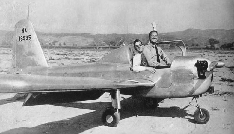
A 1944 photo (courtesy of Dan MacPherson) of famous test pilot Tony LeVier & Milo Burcham at Newhall Airport
in a "Little Dipper" (a personal aircraft developed by Lockheed in the 1940s but never mass produced).
Johan Visschedijk noted, “The photo was taken in 1944, between late August (1st flight of the Little Dipper) and October 20 (fatal crash of Milo Burcham in the 3rd YP-80A).”
The 1945 AAF Airfield Directory (courtesy of Scott Murdock) described Newhall intermediate Field
as a 52 acre rectangular property within which was a single 4,000' northwest/southeast clay & loam runway.
The field was said to not have any hangars,
to be privately owned, and operated by the Civil Aeronautics Administration.
The November 1945 USAAF Pilot's Handbook(courtesy of Chris Kennedy)
depicted Newhall as consisting of a single 4,000' sod runway,
with powerlines running directly adjacent to the southwest corner of the runway.
The 1947 LA Local Aeronautical Chart (courtesy of Tim Zukas)
depicted “Newhall (CAA)” Airport as having a 4,000' northwest/southeast runway.
According to Dan MacPherson, "The field was located along Newhall Avenue, above 16th Street.
The airport was between Newhall & San Fernando Road.
The runway was angled slightly along Newhall Avenue.
A rotating Beacon & small structure were located at the entrance, on Newhall Avenue.”
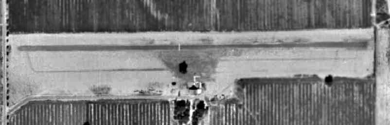
The last aerial photo which has been located showing the Newhall Airport was a 1947 aerial view.
It depicted a northwest/southeast unpaved runway, with a few small buildings on the southwest side.
There were no aircraft visible on the field.
The March 1948 LA Local Aeronautical Chart (courtesy of Chris Kennedy)
depicted "Newhall (CAA)" as having a single 4,000' northwest/southeast runway.
The last aeronautical chart depiction which has been located of Newhall Airport was on the September 1949 LA Sectional Chart.
It depicted Newhall as having a 4,000' unpaved runway.
Newhall Airport was evidently closed at some point between 1949-50,
as it was not depicted at all on the March 1950 LA Sectional Chart.
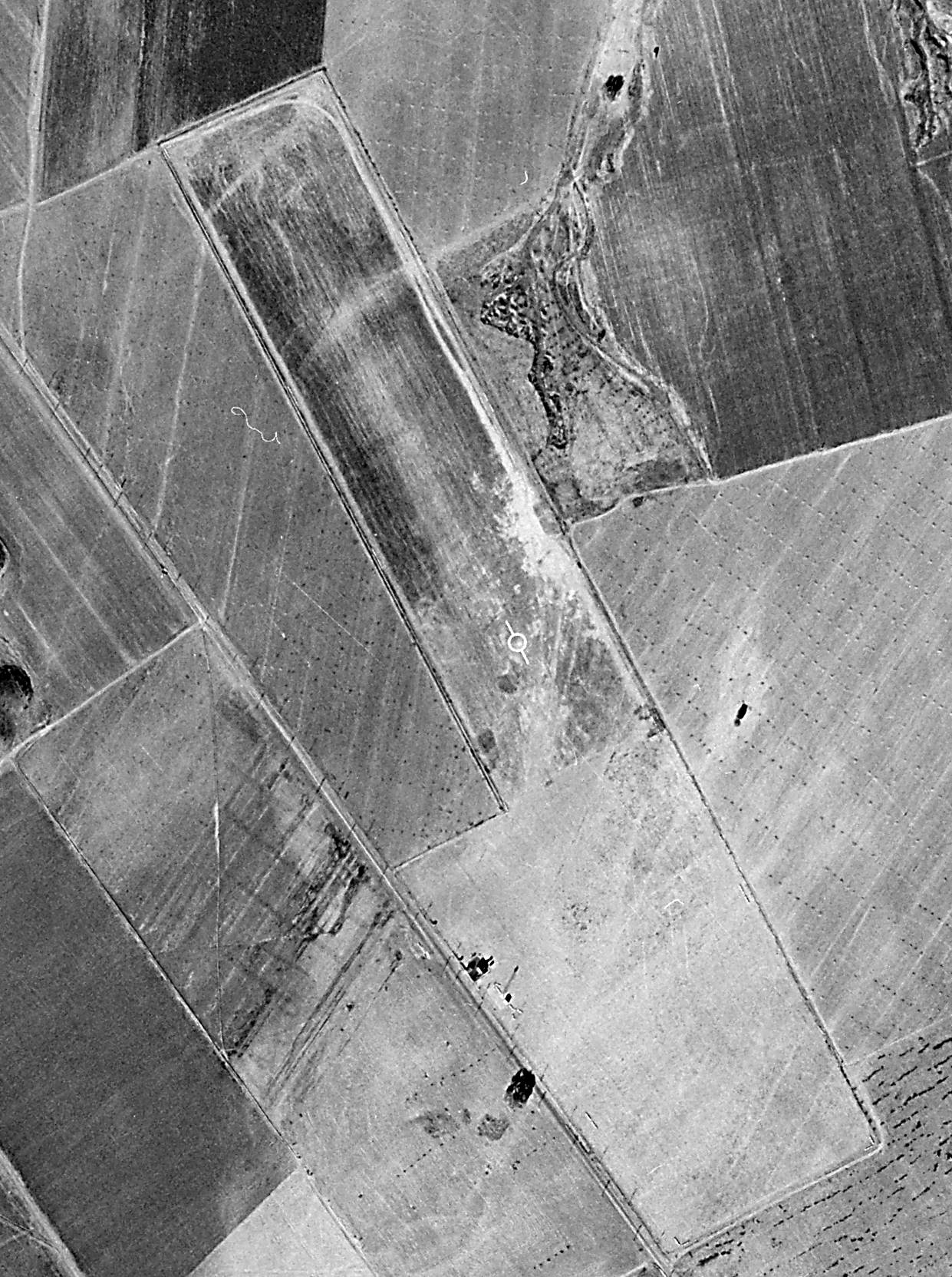
A 1952 aerial view showed the Newhall Airport runway had been removed at some point between 1947-52,
replaced by farm fields.
Apparently Newhall Airport was used by one plane long after it had closed:
on 12/30/64 a United Air Lines Convair 340, registration N73102, was on a scheduled flight from Fresno to LAX
when it made a forced "dead stick" landing on the former Newhall Airport.
The flight was under the command of United Captain Wade.
Flying over the town of Saugus, both engines stopped due to fuel management procedural issues.
Wade was able to execute a successful dead-stick landing, without any injury, and with minimal damage to the aircraft.
According to Lane Leonard, “Most people did not know it was the old airport.
My father drove over to look at it at the time it happened.”
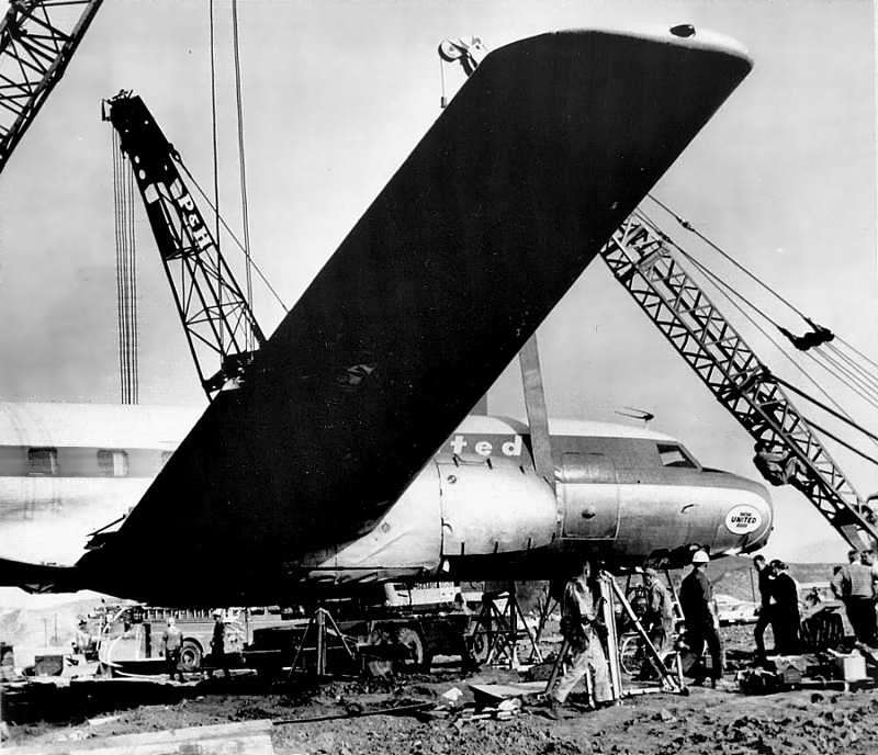
An undated photo of the United Airlines Convair 340 being repaired at Newhall after its 12/30/64 dead-stick landing.
United mechanics from LA hoisted the airplane, lowered the landing gear, replaced the propellers and some other parts.
Another United pilot made the take off from Saugus & flew the airplane gear-down to San Francisco for an in-depth mechanical analysis of the ship.
Aerial photos from 1969 & 1977 showed that the former Newhall Airport site remained unredeveloped.
The 1999 USGS topo map still depicted a "Radio Range Station" on the site of the former airport.
An 11/15/09 aerial view showed the site of Newhall Airport had been densely redeveloped, with no trace remaining of the airport.
The site of Newhall Airport is located east of the intersection of McBean Parkway & Del Monte Drive.
See also: http://www.qnet.com/~carcomm/wreck18.htm
____________________________________________________
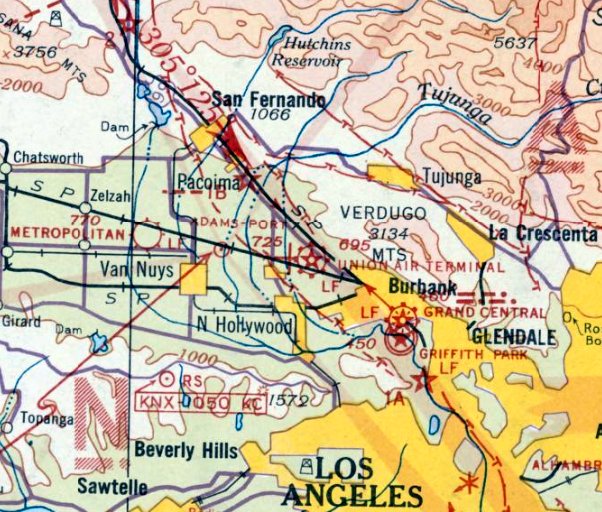
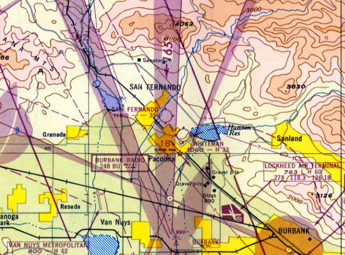
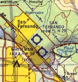
San Fernando Airport, San Fernando, CA
34.29, -118.423 (Northwest of Whiteman Airport, CA)
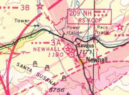
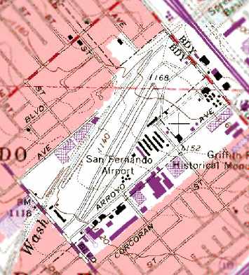
San Fernando Airport, as depicted on the March 1945 LA Sectional Chart.
According to K.O. Eckland, San Fernando Airport was established by developer Fritz Burns in 1939.
However, it was not yet depicted on the November 1939 LA Sectional Chart.
The earliest depiction of San Fernando Airport which has been located was on a 1940 Shell street map (courtesy of Dan MacPherson).
San Fernando Airport reportedly served as a military transport aircraft repair base during WW2.
However, San Fernando Airport was not depicted at all on LA Sectional Charts from 1941-44, nor on the 1945 USGS topo map.
The earliest aeronautical chart depiction which has been located of San Fernando Airport was on the March 1945 LA Sectional Chart.
It depicted San Fernando Airport as an auxiliary airfield.
Linda Kiracibasi recalled, “San Fernando Airport... my father, Robert Harms, and my mother, Margaret Harms, bought the airport after WWII.
My dad gave flying lessons & did some mechanical work & my mom ran the office.”
Virginia Fairbrother reported, “I have a picture of the dedication of the San Fernando Airport in 1945.”
The 1947 LA Local Aeronautical Chart depicted San Fernando Airport as having a 3,500' unpaved runway.
Virginia Fairbrother reported, “The owner was my uncle Richard 'Dick' Weightman.
He was a retired WW2 Air Force pilot & taught many students how to fly. He had his home on the airport property.
I visited him many times & will never forget my first plane ride in a Piper Cub when I was 8 years old in 1948.”
Linda Kiracibasi recalled, “San Fernando Airport... my father, Robert Harms, and my mother, Margaret Harms, ran it until 1951,
when my father went to work as a pilot for United Air Lines - my mother was pregnant with me & they needed a more stable income.”
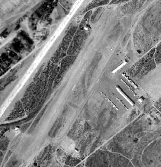
A 1953 aerial view depicted San Fernando Airport as having a single dirt runway.
The earliest depiction which has been located of San Fernando Airport was a 1953 aerial view.
It depicted the field as having a single northeast/southwest dirt runway.
Several rows of T-hangars were located on the east side of the field, around which were parked 15 light aircraft.
The 1953 USGS topo map depicted San Fernando Airport as having a single northeast/southwest runway with a parallel taxiway,
and several buildings on the east side.
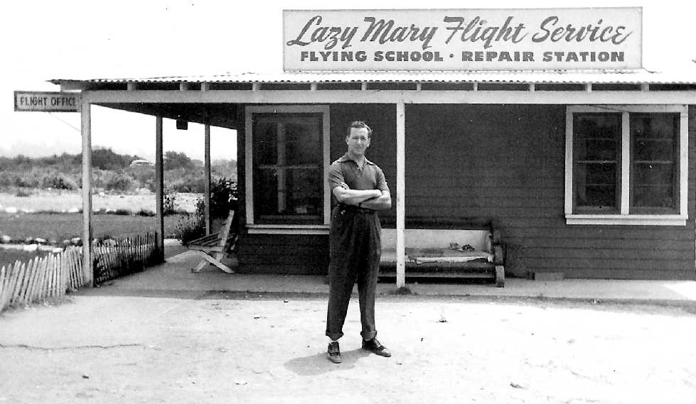
A Summer 1953 photo of the owner of the Lazy Mary Flight Service at San Fernando Airport (courtesy of Pete Hilmo).
Pete recalled, “These pics were taken when my father was flight instructing at Lazy Mary Flight service.”
A Summer 1953 photo of a Bell 47 helicopter in flight at San Fernando Airport (courtesy of Pete Hilmo).
The September 1954 USAF LA Sectional Chart (courtesy of Chris Kennedy) depicted San Fernando Airport as having a 2,400' unpaved runway.
The Civil Air Patrol's 35th Air Rescue Squadron relocated to San Fernando Airport in 1957,
according to the squadron's website.
In the 1950s & early 1960s, at the height of the Cold War, Squadron 35 was assigned the additional responsibility
of conducting Airborne Radiological Monitoring for both the military & the civil government in the event of a nuclear attack.
This duty was never carried out other than as a part of local Civil Defense drills & training.
According to Ron Stearns, “In late 1957 the squadron moved into the Q-hut with a small number of personnel,
and shortly thereafter found 2 more Q-Huts, and had a small building moved to the airport.
'Pop' Quinn was one of the original members of the unit that started with his BT with a T-6 engine, a few other T-6/SNJ aircraft, and a T-28.”
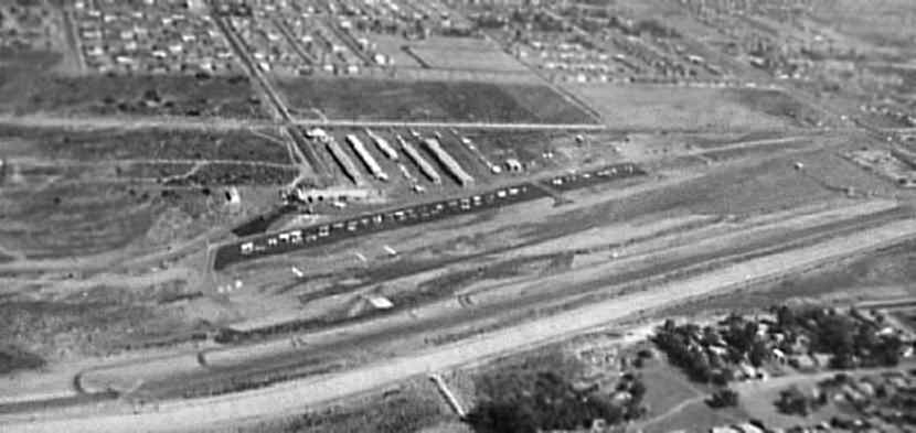
A 1958 aerial photo by Randy Hauck, looking south at San Fernando Airport.
The photo was taken from the “Whirlybirds” Bell 47 helicopter during the filming of the show (1957-60) at San Fernando Airport.
Five rows of T-hangars had been added along the south side of the runway at some point between 1953-58.
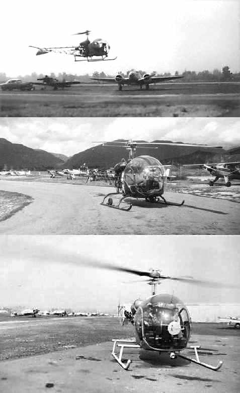
A series of 1958 photos by Randy Hauck taken at San Fernando Airport of one of the Bell 47 helicopters used in the filming of the “Whirlybirds” show,
with several other aircraft in the background.
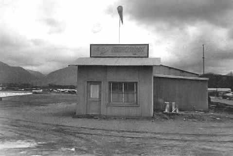
A 1958 photo by Randy Hauck of a building with a windsock at San Fernando Airport.
According to Nick Fleno, “That is the building used in the Whirlybirds TV series, where they operated out of fictitious 'Longwood Field'.
You can see the same photograph on the Whirlybirds web site.”
According to Ron Stearns, “During 1958, members of the [CAP] squadron
purchased 10 SNJs from Litchfield Park, AZ, which doubled the size of the squadron.”
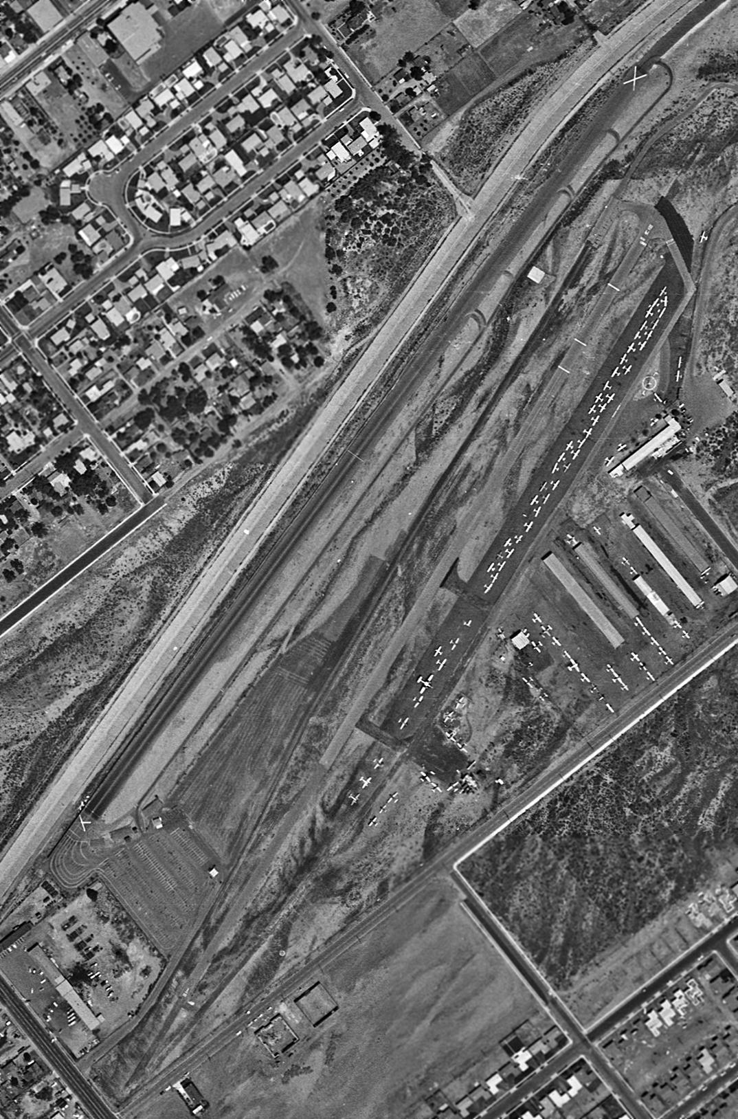
A 4/30/60 USGS aerial view showed that San Fernando Airport had gained a paved runway at some point between 1954-60.
The airport was very popular, with dozens of light aircraft visible parked on the east side.
Also note the San Fernando Drag Strip, which ran adjacent to the northwest side of the runway, and was marked with closed-runway “X” symbols to avoid confusion.
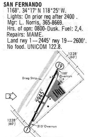
The 1962 AOPA Airport Directory described the San Fernando Airport as having a single 3,000' hard surface Runway 1/19.
The operator was listed as Ryan Air Service,
and the Harry Campbell Comet Copters helicopter flight school also operated from the airport.
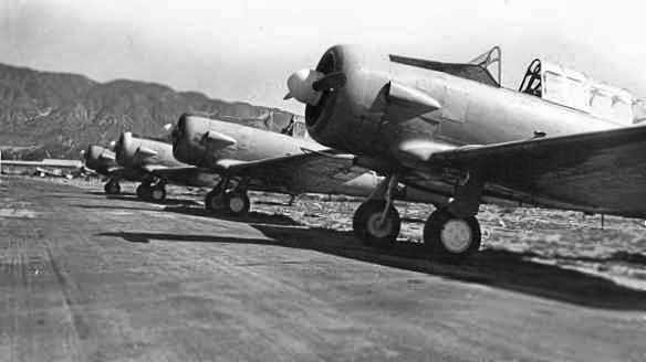
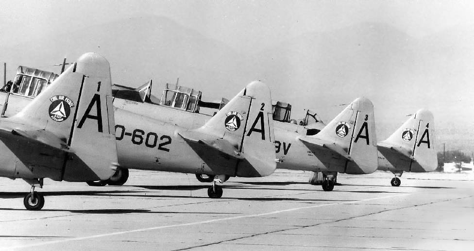
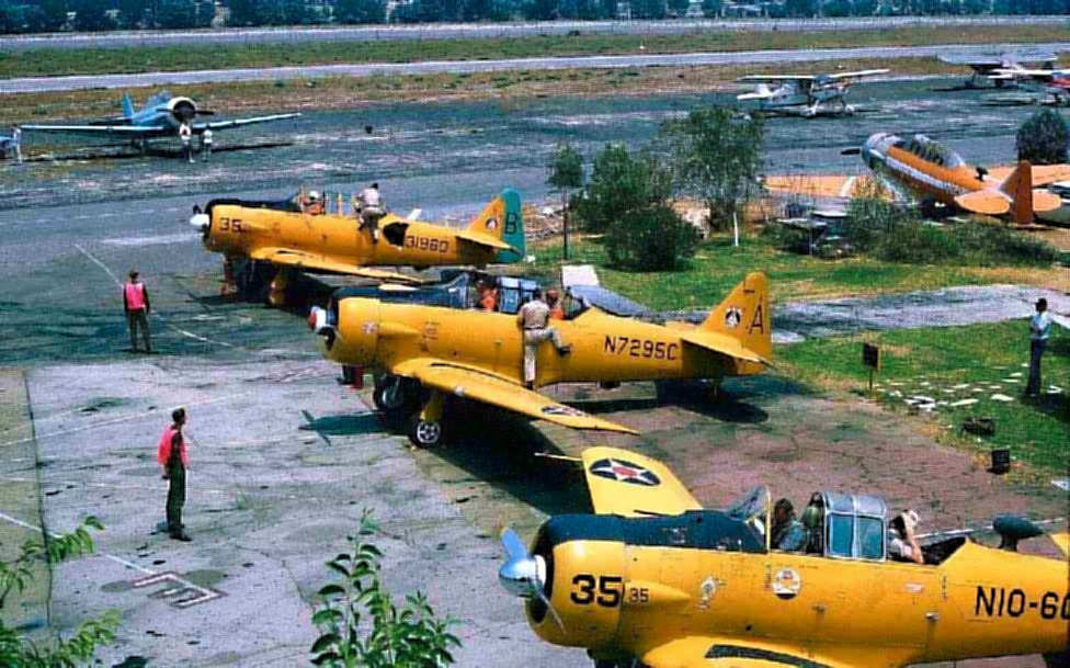
A circa 1960s photo of 4 T-6 Texans of the San Fernando Airport Civil Air Patrol 35th Squadron.
In the early 1960s, San Fernando Airport's Civil Air Patrol 35th Squadron became well-known in the aviation community
for operating a fleet of 12 North American T-6/SNJ-5 Texans, 1 Vultee BT-13 Valiant, 2 Beechcraft C-45 Expeditors and 1 Piper L-4 Super Cub.
These aircraft logged over 12,000 hours of search mission time & accounted for 70% of the ‘finds’ made by CAP in the Southern California area.
With the exception of the Corporate owned L-4, these aircraft were all privately owned & maintained.
As a mark of unity the members pained their aircraft the same yellow & red colors used in World War II, with a few minor personal touches.
A circa 1960s photo of 4 T-6 Texans of the San Fernando Airport Civil Air Patrol 35th Squadron.
A circa 1960s photo of a T-28 Trojan & T-6 Texan of the San Fernando Airport Civil Air Patrol 35th Squadron.
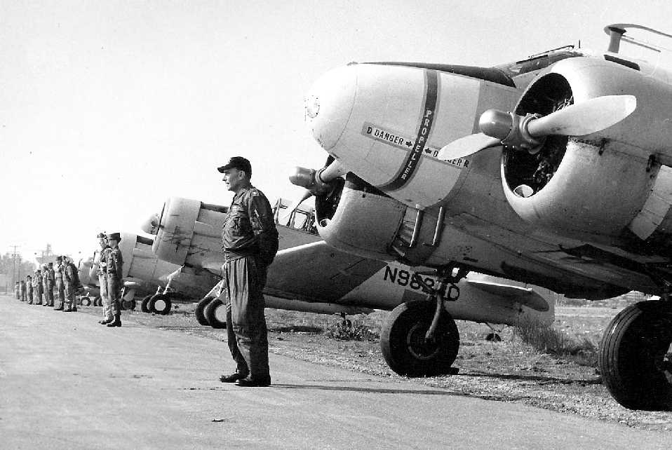
A circa 1960s photo of a lineup of a Beech C-45 Expeditor & several T-6 Texans of the San Fernando Airport Civil Air Patrol 35th Squadron.
According to Ron Stearns, “By the very early 1960s, the [CAP] squadron grew to near 25 T-6/SNJ/Harvard aircraft, five T-28s and three C-45s.”
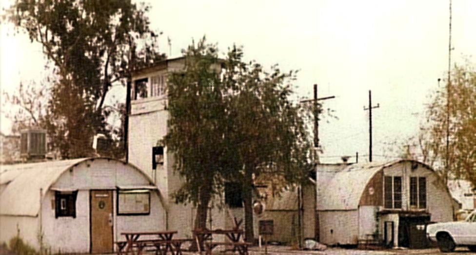
An early 1960s photo of the headquarters buildings at the San Fernando Airport of the Civil Air Patrol 35th Squadron (courtesy of Ron Stearns).
A mid-1960s photo at San Fernando Airport of the Civil Air Patrol 35th Squadron's T-6 Texans (courtesy of Ron Stearns).
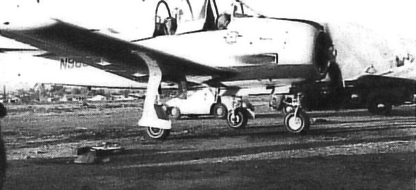
Fred Austin recalled, “In 1963 I had a Ryan PT-22 I kept at San Fernando. The PT-22 cost me $1,700.
The Civil Air Patrol had a bunch of AT-6s there. The fellow with the air service there was Tom Ryan.
He was a professor at Glendale College. His sister Pat was married to Richard Nixon.
I got my private license from Mr. Ryan. He was a designee for several ratings.
You could rent an Aeronca Champ wet for $9 / hour. The biggest airplane on the field at that time was a T-28.
Pat Quinn's dad had a BT-13 with a P&W1340 (AT-6 Engine) on it.”
The August 1964 LA Local Aeronautical Chart (courtesy of Donald Felton) depicted San Fernando as having a 2,900' hard surface runway.
San Fernando's entry from a 1968 airport directory (courtesy of Glenn Beltz).
It also depicted the San Fernando Drag Strip, which ran adjacent to the northwest side of the runway.
During the early 1970s, the San Fernando CAP squadron’s T-6s were replaced by 2 more fuel efficient & economical Cessna 0-1 Bird Dogs.
Many of the old Texans were sold or transferred to Van Nuys Senior Squadron 135.
A 1972 aerial view depicted San Fernando's paved runway. The number of aircraft visible on the field had blossomed to over 100.
Bill Putney recalled from the early 1970s, "I took my check ride from a guy that was the chief pilot of a school based at San Fernando.
He had a 3 digit certificate number I think & put the airplane in a spin with me under the hood & told me to recover as my 'practical' test.
San Fernando was an interesting airport. It had wind socks at both ends of the runway & they frequently were pointing in different directions.
The downwind at San Fernando was parallel & pretty close to the base for Whiteman.
Then there were the big power transmission lines at one end of the runway.
I use to have bad dreams about loosing power on final & having to decide if I should go over or under those lines."
Bob Hyatt recalled, “I worked as a flight instructor at San Fernando Airport from March-August 1973,
my first job as a Certified Flight Instructor, when the Fixed-Base Operation was operated by Wayne Williams.
During my time at SFR, I accumulated about 400 hours of Pilot In Command time.”
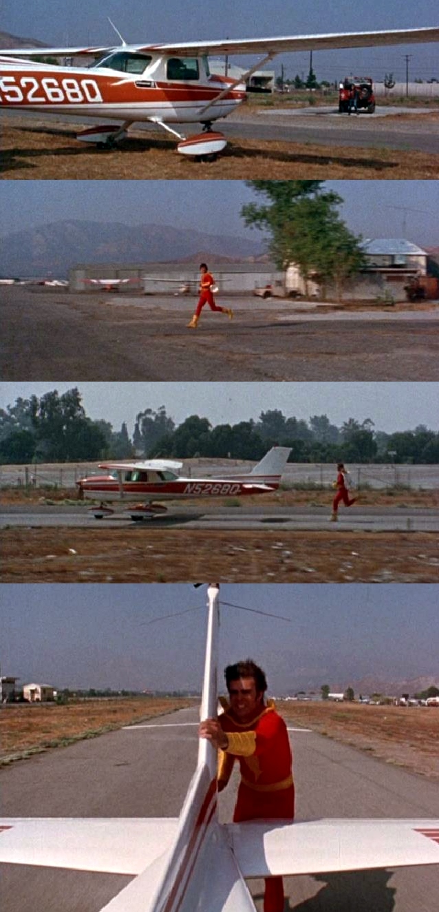
A series of stills of San Fernando Airport from the 1974 episode "The Treasure” of the TV series “Shazam” (courtesy of Bill Bazen),
of the hero chasing & apparently stopping a Cessna 150L.
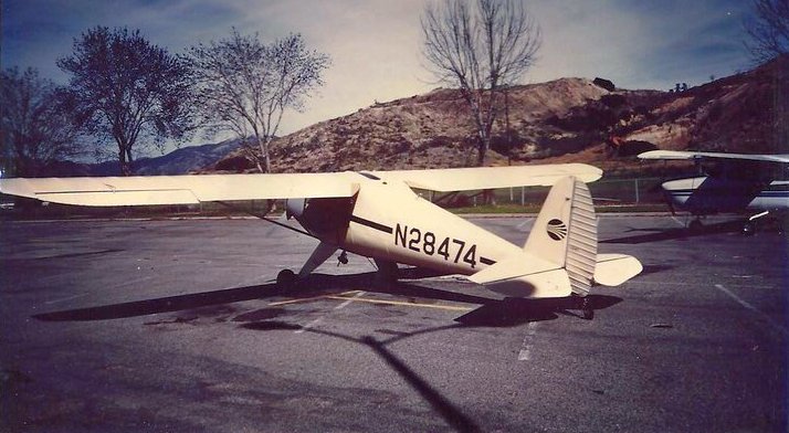
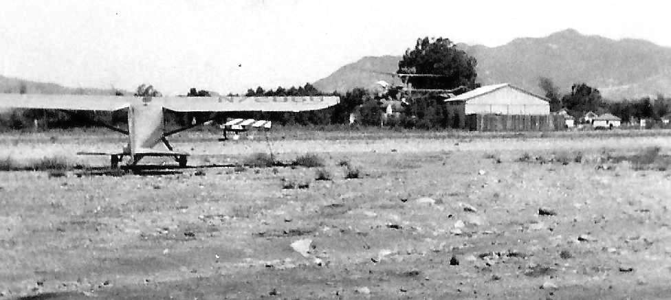
A 1977 photo of a 1940 Luscombe 8A at San Fernando Airport.
The July 1980 LA Terminal Chart (courtesy of Jim Hackman) depicted San Fernando Airport as having a 2,900' paved runway.
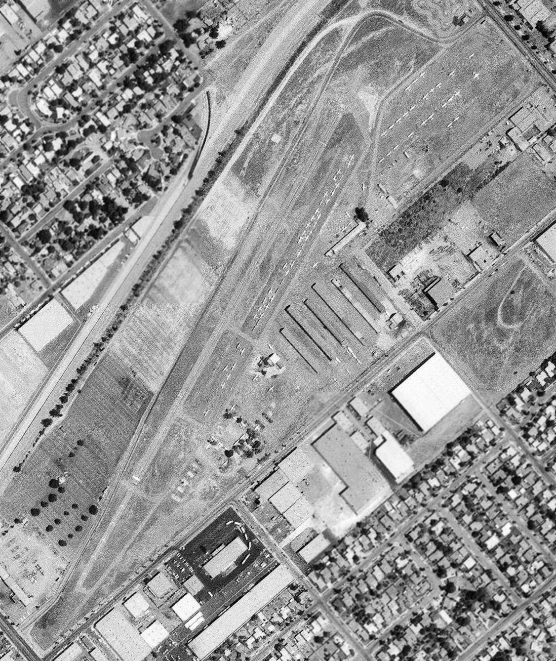
A 9/2/82 USGS aerial view showed that San Fernando Airport was very well-used right up to the very end,
with over 70 light aircraft visible parked on the field.
The last aeronautical chart depiction which has been located of San Fernando Airport was on the January 1982 LA Sectional Chart,
which depicted San Fernando as having a 2,300' paved runway.
Ken Forbes recalled, “San Fernando Airport... I got my license there in early 1980s.”
During 1983, Ford TriMotor 5-AT-74 was flown out of the San Fernando Airport by Art Scholl & Bernie Godlove
during a brief movie career in which it appeared in the movie "To Be or Not To Be".
Its beautiful rainbow was temporarily painted out by dozens of cans of silver hairspray in order for it to represent Hilter's personal German Ju-52.
San Fernando Airport closed in 1985, and its Civil Air Patrol Squadron relocated to Whiteman Airport.
San Fernando Airport was no longer depicted on the January 1986 LA Sectional Chart.
A circa late 1980s photo of the San Fernando Airport entrance sign (courtesy of Ken Forbes).
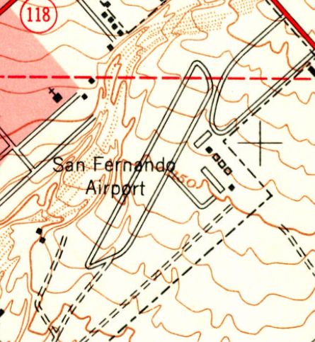
Even though it had already been closed for 3 years, San Fernando Airport was still depicted on the 1988 USGS topo map.
It depicted the airport as having a single 3,000' runway, a parallel taxiway, and several hangars southeast of the runway.
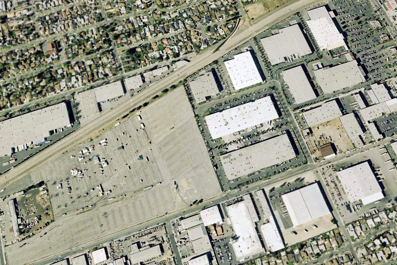
A 2006 aerial view looking northwest showed the northeastern half of San Fernando Airport had been covered in commercial buildings,
and the southwestern portion had been completely paved over.
However, a solitary piece of evidence remained plainly visible to indicate that this used to be an airport:
a closed-runway "X" marking still remained on what used to be the southwestern portion of the runway (below-left of the center of the photo).
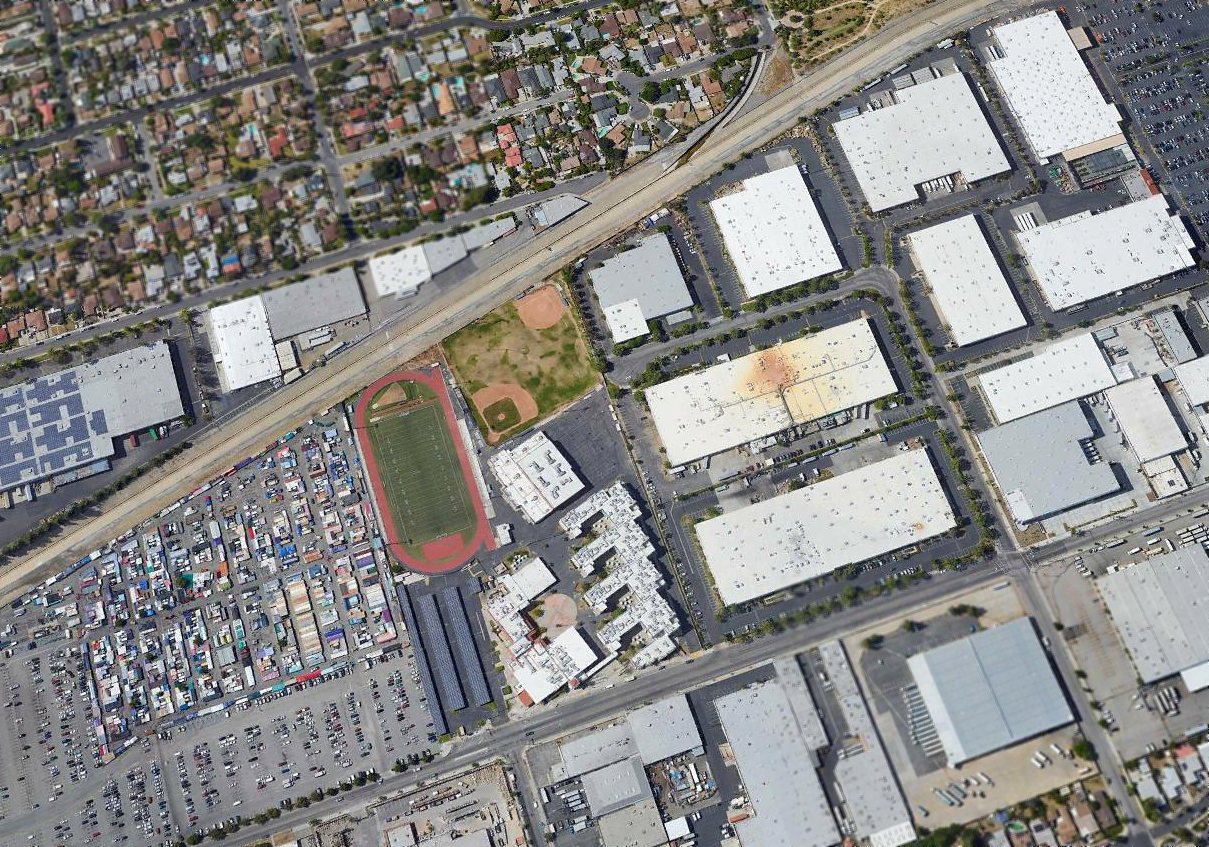
A 2017 aerial view looking northwest showed no trace remains of San Fernando Airport.
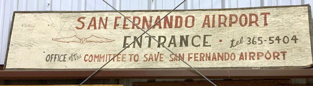
Ken Forbes reported in 2019, “San Fernando Airport... I have the 'SAVE THE SFA' sign that was at the entrance to the airport.
I got it the day they were tearing it down. It might be the only thing left.”
The site of San Fernando Airport is located north of the intersection of Dronfield Avenue & Aviation Place, appropriately enough.
Thanks to Jerry Mullady for pointing out this airfield.
____________________________________________________
Since this site was first put on the web in 1999, its popularity has grown tremendously.
If the total quantity of material on this site is to continue to grow,
it will require ever-increasing funding to pay its expenses.
Therefore, I request financial contributions from site visitors,
to help defray the increasing costs of the site
and ensure that it continues to be available & to grow.
What would you pay for a good aviation magazine, or a good aviation book?
Please consider a donation of an equivalent amount, at the least.
This site is not supported by commercial advertising –
it is purely supported by donations.
If you enjoy the site, and would like to make a financial contribution,
you
may use a credit card via
![]() :
:
Please consider checking the box to make a monthly donatation.
For a mailing address to send a check, please contact me at: paulandterryfreeman@gmail.com
If you enjoy this web site, please support it with a financial contribution.
This site covers airfields in all 50 states.