
Abandoned & Little-Known Airfields:
California: Southeastern San Bernardino County
© 2002, © 2024 by Paul Freeman. Revised 10/26/24.
This site covers airfields in all 50 states: Click here for the site's main menu.
For the 6th year, the CA pages of this website are sponsored by the California Pilots Association:
____________________________________________________
Please consider a financial contribution to support the continued growth & operation of this site.
Amboy Airport / Conn Airport / Roy Airport (revised 7/29/23) - Bagdad Intermediate Field (revised 7/8/18) - Camp Coxcomb AAF / Coxcomb Airfield (revised 10/26/24)
Camp Essex AAF / Essex Airport (revised 4/3/20) - Camp Goffs AAF (revised 3/31/21) - Giant Rock Airport (revised 9/28/23)
Goffs Intermediate Field (revised 10/26/24) - Riverview Airport (revised 7/29/23) - Surprise Springs MCAF (revised 3/23/20)
Twenty Nine Palms Airport / Condor Field (revised 4/25/20) - Walters Ranch Airfield (revised 10/26/24)
____________________________________________________
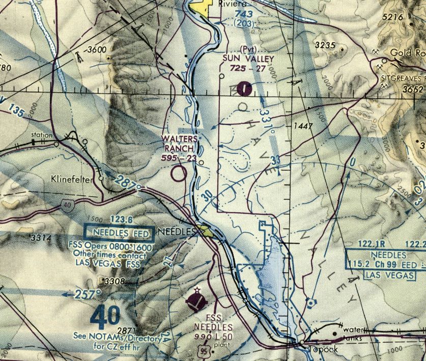
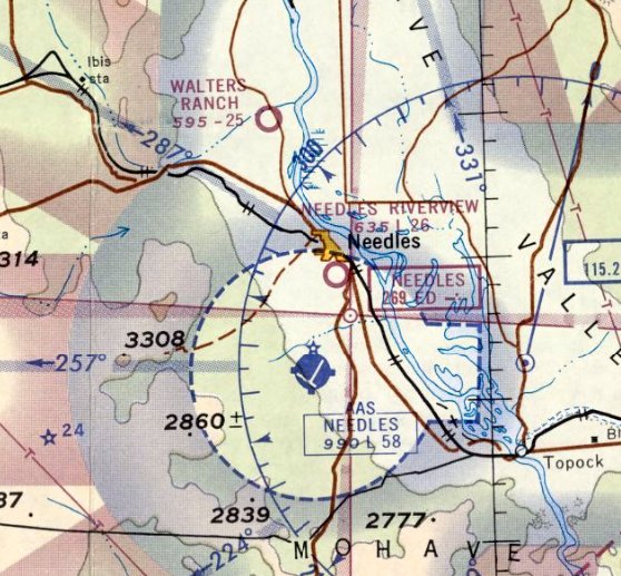
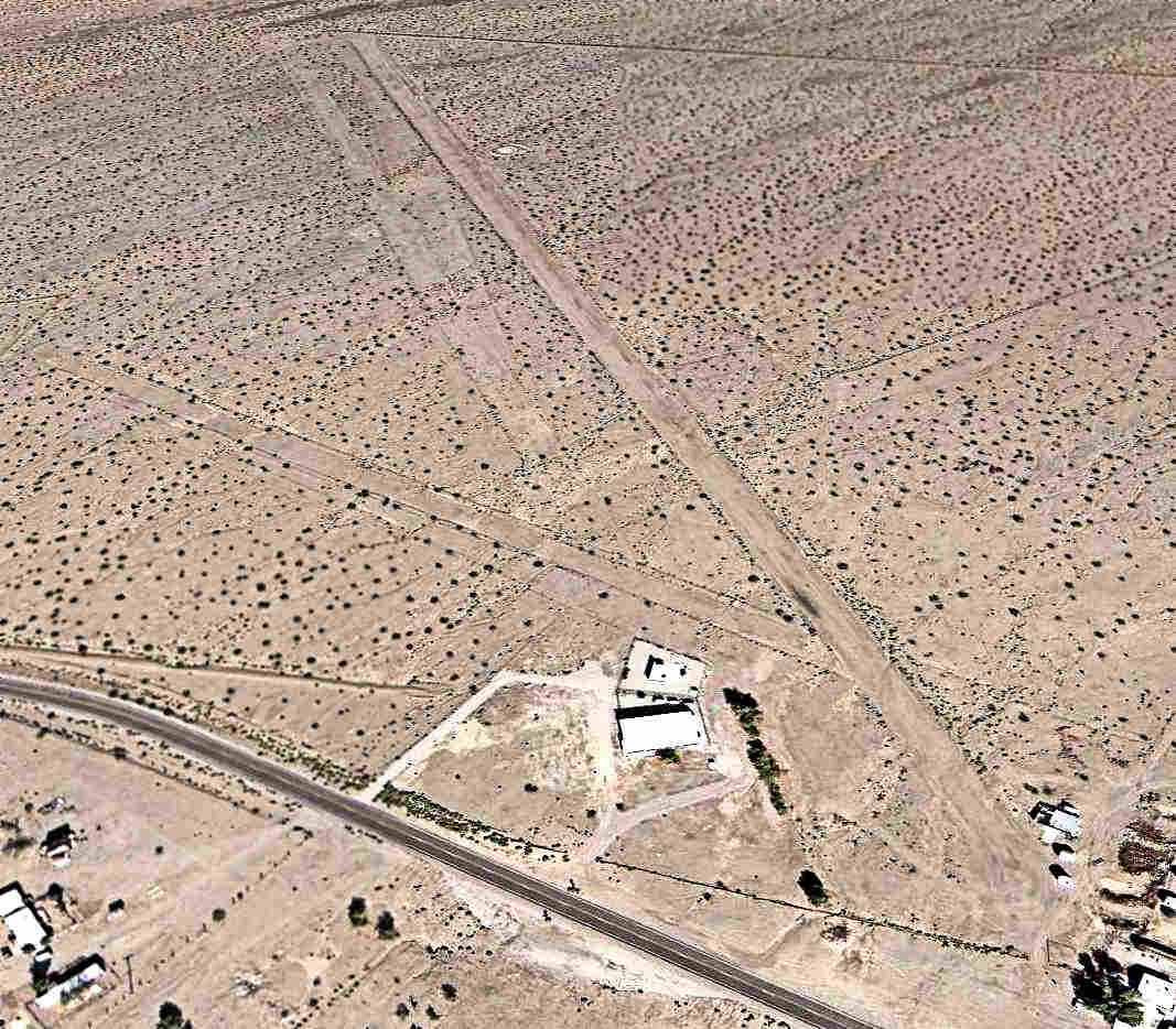
Walters Ranch Airfield, Needles, CA
34.911, -114.648 (Southeast of Las Vegas, NV)
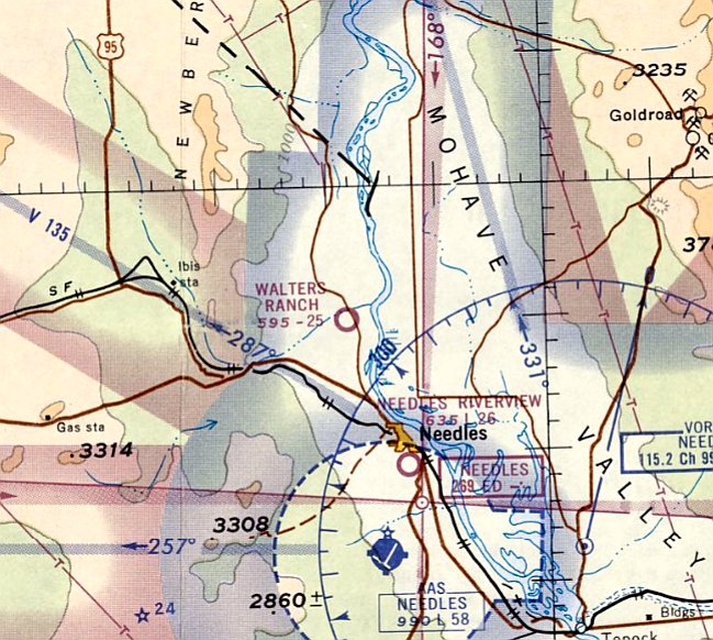
Walters Ranch Airfield, as depicted on the March 1965 Los Angeles Sectional Chart.
Photo of the airfield while in use has not been located.
This small airfield was evidently established at some point between 1961-65,
as Walters Ranch Airfield was not yet depicted on a 1947 aerial photo nor on the March 1961 LA Sectional Chart.
The earliest depiction which has been located of Walters Ranch Airfield was on the March 1965 Los Angeles Sectional Chart.
It depicted Walters Ranch Airfield as having a 2,500' unpaved runway.
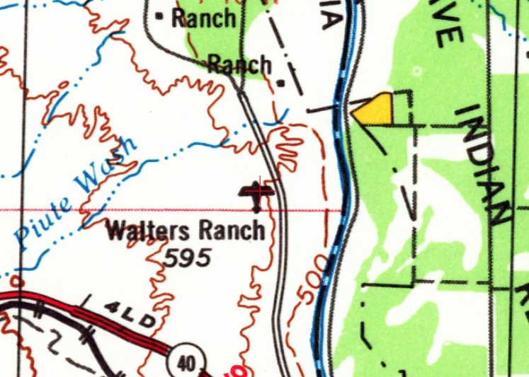
The earliest topo map depiction which has been located of Walters Ranch Airfield was on the 1969 USGS topo map.
The March 1969 Los Angeles Sectional Chart depicted Walters Ranch Airfield as having a 2,300' unpaved runway.
The earliest photo which has been located of Walters Ranch Airfield was on a 1969 aerial view, which depicted 3 unpaved runways.
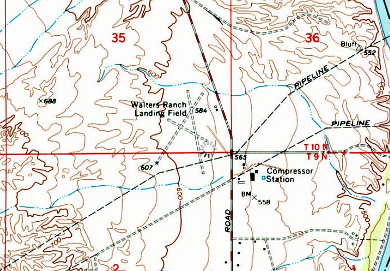
The 1970 USGS topo map depicted “Walters Ranch Landing Field” as having 3 unpaved runways & 2 small buildings on the northeast side.
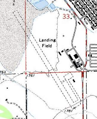
A 1977 ACSC map (courtesy of Kevin Walsh) depicted the Walters Ranch Airfield as a single northwest/southeast runway, generically labeled “Landing Field”.
The last aeronautical chart depiction which has been located of Walters Ranch Airfield was on the 1978 Los Angeles Sectional Chart (courtesy of Jonathan Westerling).
It depicted Walters Ranch Airfield as having a 2,300' unpaved runway.

The last topo map depiction which has been located of Walters Ranch Airfield was on the 1985 USGS topo map.
It depicted “Walters Ranch Landing Field” as having 2 runways.
A 1987 ACSC map (courtesy of Kevin Walsh) depicted the Walters Ranch Airfield as a rectangular property outline, generically labeled “Landing Field”.
Walters Ranch Airfield had evidently been closed (for reasons unknown) at some point between 1978-88,
as it was no longer depicted on the 1988 Los Angeles Sectional Chart (courtesy of Jonathan Westerling).
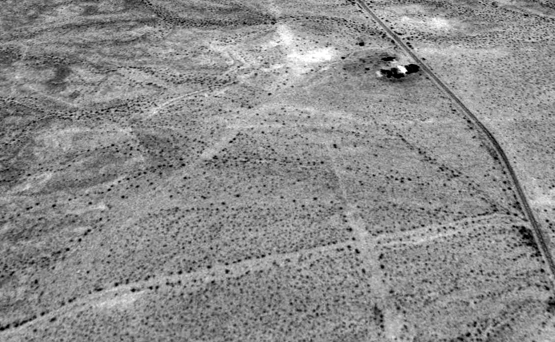
The earliest photo which is available of Walters Ranch Airfield was a 1994 aerial view looking north, which depicted 3 unpaved runways, and possibly some small buildings on the northeast side.
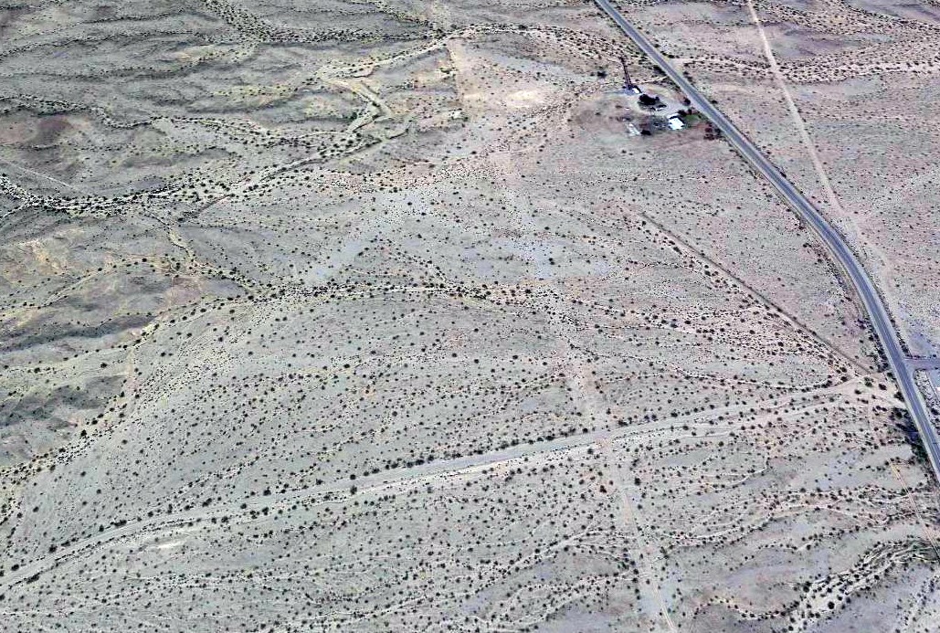
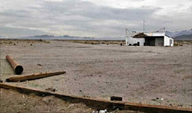
A 2020 aerial view looking north depicted Walters Ranch Airfield as having 3 unpaved runways & some small buildings on the northeast side.
A 2022 photo looking west showed the hangar remaining on the northeast side of Walters Ranch Airfield.
Thanks to Kevin Walsh for pointing out this airfield.
____________________________________________________
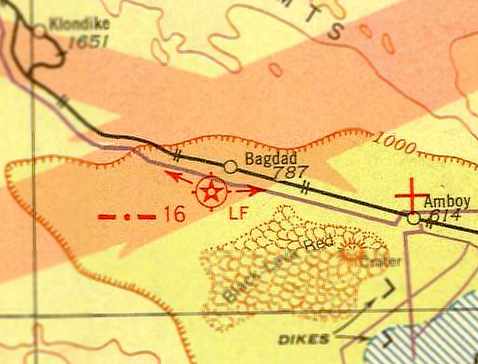
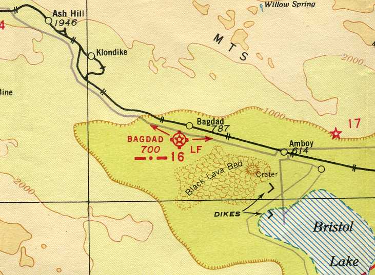
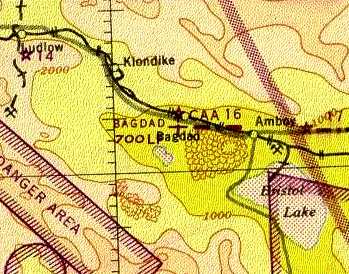
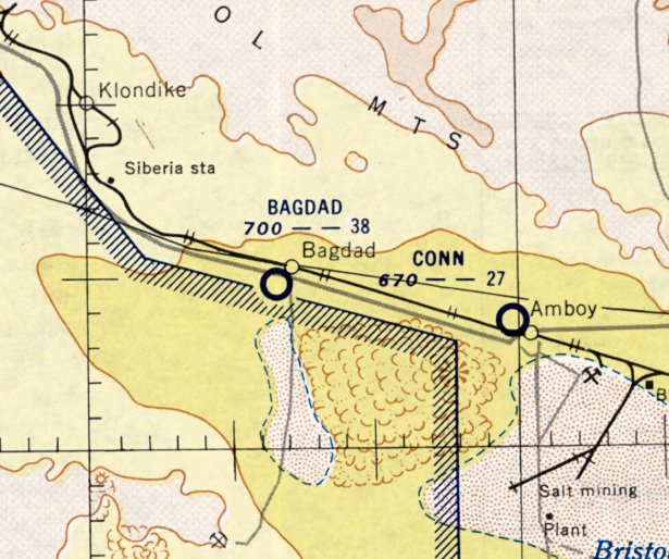
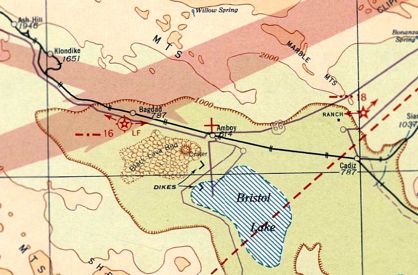
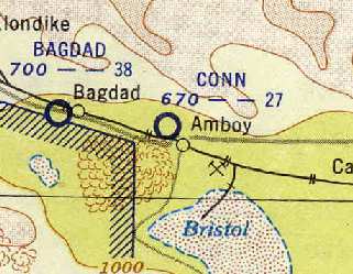
Bagdad Intermediate Field, Bagdad, CA
34.57, -115.88 (Northeast of Los Angeles, CA)
Bagdad Intermediate Field, as depicted on the June 1932 LA Airway Chart (courtesy of Scott O'Donnell).
Photo of the airfield while in use has not been located.
The airfield in Bagdad was constructed as one of the Department of Commerce's network of Intermediate Fields,
which were established for the emergency use of commercial aircraft flying airways between major cities.
Bagdad Intermediate Field was evident constructed at some point between 1930-31,
as it was not yet listed among active airfields in the 1930 Department of Commerce Airway Bulletin #5 (according to David Brooks).
The earliest reference to the Bagdad Intermediate Field which has been located
was its listing in the 1931 Department of Commerce Airway Bulletin #2 (according to David Brooks).
The earliest depiction of the Bagdad Intermediate Field which has been located was on the June 1932 LA Airway Chart (courtesy of Scott O'Donnell).
It depicted Bagdad as a lighted field with Beacon #16 along the Los Angeles - Kingman Airway.
Bagdad Intermediate Field was listed among active airfields in The Airport Directory Company's 1933 Airport Directory (according to David Brooks).
Bagdad Intermediate Field, as depicted on the June 1940 Sectional Chart (courtesy of Chris Kennedy).
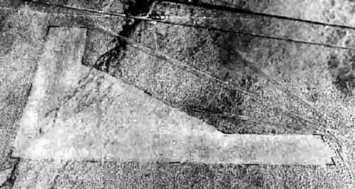
The earliest photo which has been located of Bagdad Intermediate Field
was a 6/25/43 aerial view looking north from the 1945 AAF Airfield Directory (courtesy of Scott Murdock, enhanced by Bill Grasha).
It depicted Bagdad as having 2 unpaved runways in an L-shape.
There did not appear to be any buildings at the airfield.
The 1945 AAF Airfield Directory (courtesy of Scott Murdock) described Bagdad Intermediate Field
as a 156 acre L-shaped property having 2 rough gravel 3,960' runways, oriented north/south & east/west.
The field was described as not having any hangars,
to be owned by the U.S. Government, and operated by the Civil Aeronautics Administration.
The 1945 Mojave AAF Aeronautical Chart depicted Bagdad as an auxiliary airfield.
Bagdad Intermediate Field was listed among active airfields in the 1946 Haire Airport Directory (according to David Brooks).
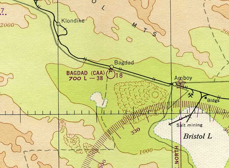
The February 1949 Sectional Chart (courtesy of Chris Kennedy) depicted “Bagdad (CAA)” as having a 3,800' unpaved runway.
Bagdad Intermediate Field was listed among active airfields in the 1953 Aviation Week Airport Directory as a CAA Emergency Field (according to David Brooks).
The Bagdad Intermediate Field was not depicted at all on USGS topo maps from the 1950s, 1960s, or 1980s.
The last aeronautical chart depiction which has been located of Bagdad Intermediate Field was on the March 1955 LA Sectional Chart.
It depicted Bagdad as having a 3,800' unpaved runway.
The Bagdad Intermediate Field was evidently abandoned at some point between 1955-58,
as it was no longer depicted on the March 1958 Los Angeles Sectional Chart (according to Chris Kennedy).
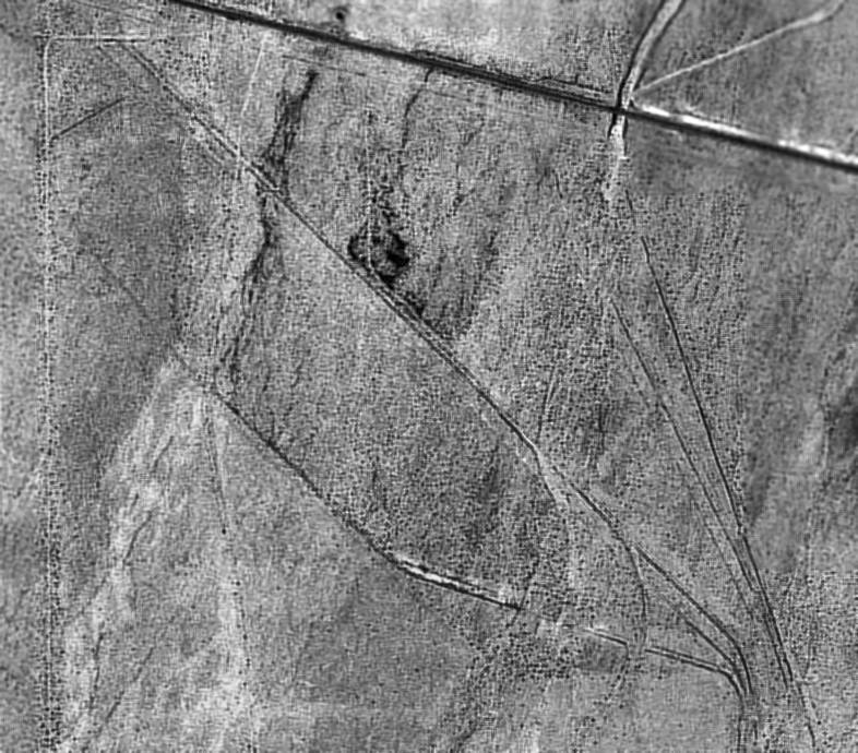
In the 1994 USGS aerial photo, the outlines of the Bagdad runways were still barely discernible.
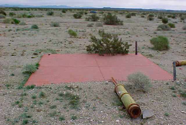
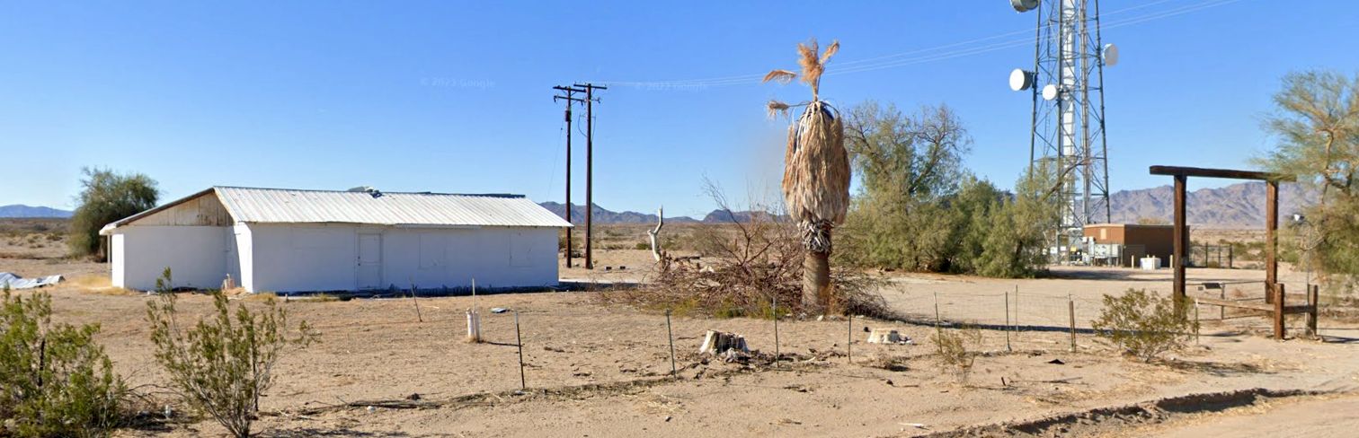
A 2008 photo by Charles Irvin looking east at the red painted base of the airway beacon tower that was adjacent to the airfield generator shed at the Bagdad Airfield site.
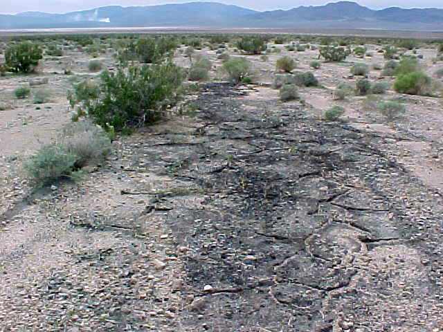
A 2008 photo by Charles Irvin looking along what was presumably the oiled runway surface at the Bagdad Airfield site.
Charles reported, “The field isn't asphalt - it's oiled (VERY badly deteriorated), and the oiled area is MUCH larger than the outline of the field that you can see on [aerial photos] -
the oiled areas extend nearly right up to Old Route 66!
It's basically a square oiled pad... can't tell by the satellite images (unless each runway was 300'+ wide!).
The ENTIRE landing area, as well as the area covered from the angled runway, all the way up to the highway, is oiled,
and is buried in anywhere from an inch, to up to 2 feed of sand.
The dark areas that you see in the [aerial] image on the area, are actually spots where the oiled surface is still visible:
that's why there's much less vegetation on the airfield area, than there is in the surrounding areas.
The E/W runway appears to have been used up until the demise of Bagdad proper,
as there's the image of a narrower runway with taxiway atop the old runway (possibly 2 parallel runways?) that extends east of the original eastern boundary of the field
and stops shy of the western boundary of the field.
It appears that the airway marker may still be visible at the northern end of the field, though I couldn't find it when there, due to lack of time, and the sun setting.”
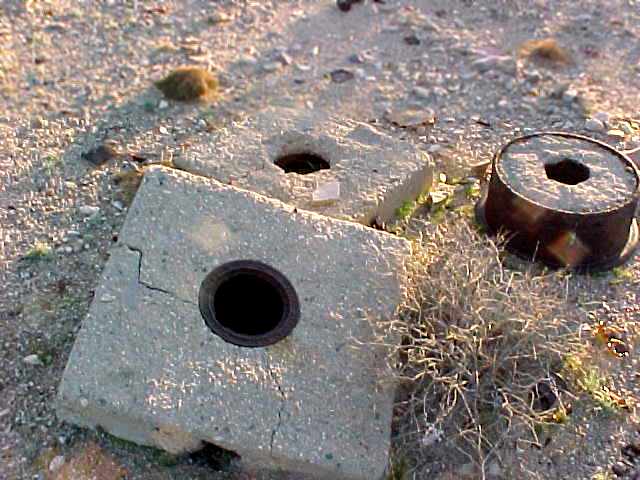
A 2008 photo by Charles Irvin of what were presumably connections to an underground fuel supply at the Bagdad Airfield site.
Charles observed, “There's evidence that there was underground fuel at this location at one time -
I got pics of what look like the filler openings for underground tanks, manufactured by Cox Co., L.A., CA,
and they weren't too far from a square area that was kind of sunken, and had remains of a few pieces of wood over it.”
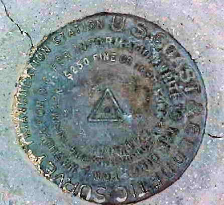
A 2008 photo by Charles Irvin of a USGS benchmark at the Bagdad Airfield site.
A 2008 photo by Charles Irvin looking west at what was presumably a generator stand at the Bagdad Airfield site.
Steve Owen observed, “Interesting that they bothered to put a red overlay on the entry step to the shed!”
A 2013 aerial view showed the outlines of the Bagdad runways to remain recognizable.
A 2/11/16 photo by Steve Owen looking south at the red-capped concrete pad which was the base of the airway beacon tower adjacent to the airfield generator shed at the site of Bagdad Intermediate Field.
Steve observed, “I did not find much else, except the smoke on the mountainside is actually from Marine Corps bombing or artillery practice.
As I surveyed the site there were frequent multiple explosions, far distant, for as long as I was out there.”
The site of the Bagdad Intermediate Field is located south of the intersection of National Trails Highway & Bagdad Way.
____________________________________________________
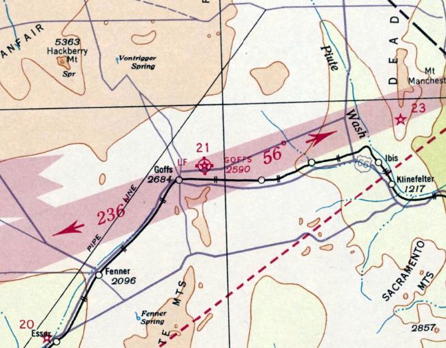
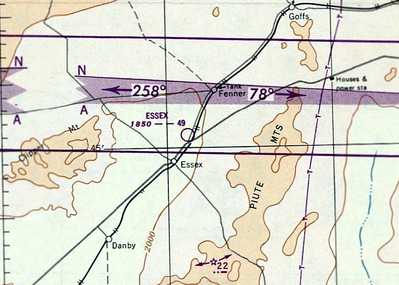
Goffs Intermediate Field, Goffs, CA
34.93, -115.03 (Northeast of Los Angeles, CA)
The Goffs Airfield, as depicted on the June 1932 LA Sectional Chart.
Photo of the airfield while open has not been located.
An airfield was constructed at Goffs at some unknown date, prior to 1932.
The earliest depiction which has been located of Goffs Intermediate Field was on the June 1932 LA Sectional Chart.
It depicted Goffs as Commerce Department Site 21 along the Los Angeles - Kingman Airway, with a rotating beacon light & course lights.
The Goffs Intermediate Field was listed in The Airport Directory Company's 1933 Airports Directory (according to Chris Kennedy).
The Airport Directory Company's 1937 Airports Directory (courtesy of Bob Rambo)
described the Department of Commerce Intermediate Field at Goffs as "Site 21" along the LA-Amarillo airway.
It was described as having 3 sod & dirt landing strips, with the longest being a 4,000' northeast/southwest strip.
The last aeronautical chart depiction which has been located of Goffs Intermediate Field was on the March 1937 LA Sectional Chart.
It depicted Goffs as Commerce Department Site 21 along the Los Angeles - Kingman Airway, with a rotating beacon light & course lights.
According to"Goffs & Its Schoolhouse” by Dennis Casebier (via Art Wilson),
the Goffs emergency airport was dismantled & the equipment taken to Blythe the week of 4/30/37.
The Goffs Intermediate Field was listed in The Airport Directory Company's 1938 Airports Directory (according to Chris Kennedy).
The Goffs Intermediate Field was evidently closed at some point in 1938,
as it was no longer depicted on the December 1938 Los Angeles Sectional Chart,
nor listed in The Airport Directory Company's 1941 Airports Directory (according to Chris Kennedy)
nor in the 1945 AAF Airfield Directory (courtesy of Scott Murdock).
[Note that the nearby Camp Goffs Army Airfield, established during WW2, was a separate facility 2 miles to the west.]
The earliest photo which has been located of the Goffs Intermediate Field was a 4/23/53 USGS aerial view.
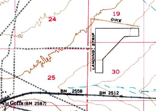
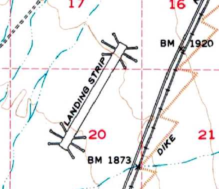
The 1956 USGS topo map depicted the irregular outline of the Goffs Intermediate Field, labeled simply as “Landing Strip”.
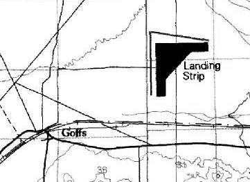
The 1985 USGS topo map (courtesy of Kevin Walsh) depicted the irregular outline of the Goffs Intermediate Field, labeled simply as “Landing Strip”.
The Goffs airfield was not depicted at all (even as an abandoned airfield) on 2002 aeronautical charts.
A 2003 photo by Chris Kennedy looking north at the remains of the Goffs airfield.
Chris noted, "I didn't try to get to it because it is just too far off the main roads."
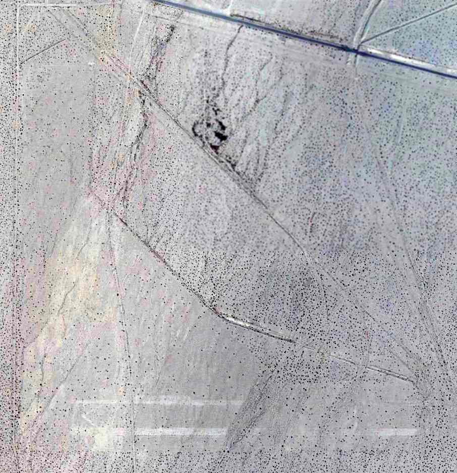
A 5/17/12 aerial view by Chris Kennedy looking northeast at the remains of Goffs Intermediate Field, taken from a Bonanza.
Chris reported, “It's very difficult to pick out the shape of the field from this angle though.
The easiest feature to pick out is the diagonal just right of the center where there is a slight change in the growth on the ground.
If you compare this photo to the [overhead] aerial, this line is the outside boundary of the diagonal runway. From there you can kind of work out the shape.
The 2 parallel roads that can be seen running diagonally across the photo in the lower left are just outside the western edge of the north/south runway.”

In a 2014 aerial photo, the outlines of the runways & ramp area were just barely discernible.
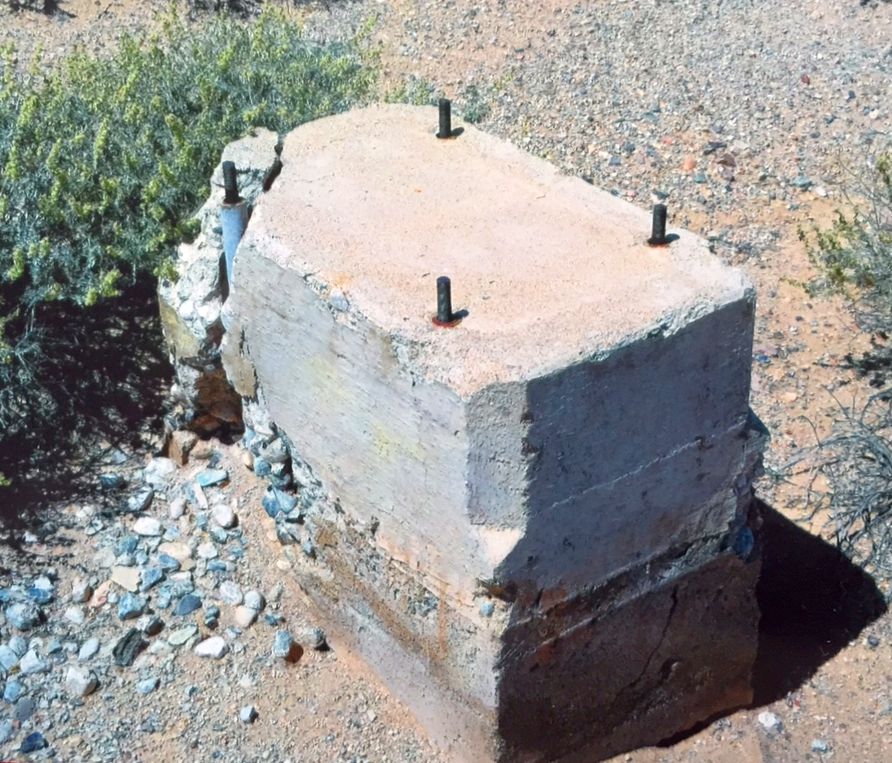
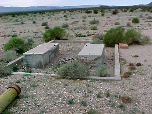
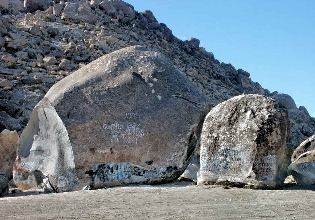
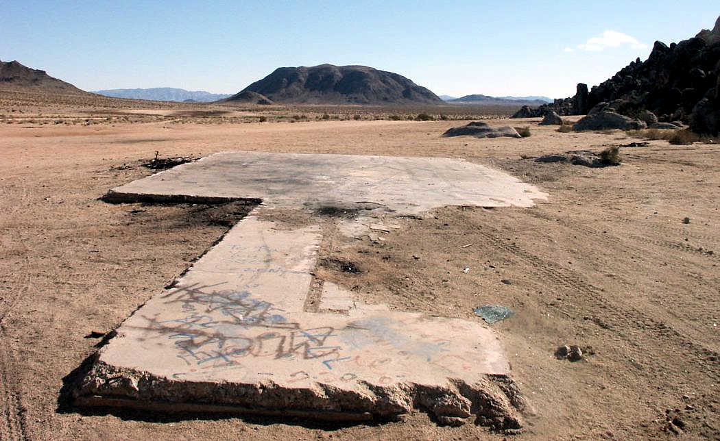
A March 2016 photo by Francis Blake at Goffs, of one of “Many concrete blocks with anchors on the site.”
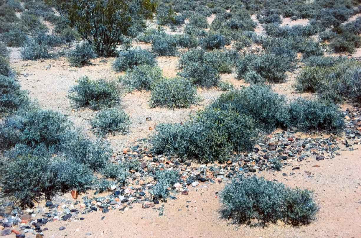
A March 2016 photo by Francis Blake at Goffs, of “Part of the compass rose in the northwest corner of the field.
Small rocks had been painted white.
The buildings (I counted 6 foundations & concrete slabs, two of which were 2-car garages) were a short ways to the southwest of the compass.”
A March 2016 photo by Francis Blake at Goffs, of possible fragments of the airport beacon lens?
The site of the Goffs Intermediate Field is located 2 miles northeast of the intersection of Route 66 & Goffs Road.
____________________________________________________
Camp Goffs Army Airfield, Goffs, CA
34.94, -115.07 (Northeast of Los Angeles, CA)
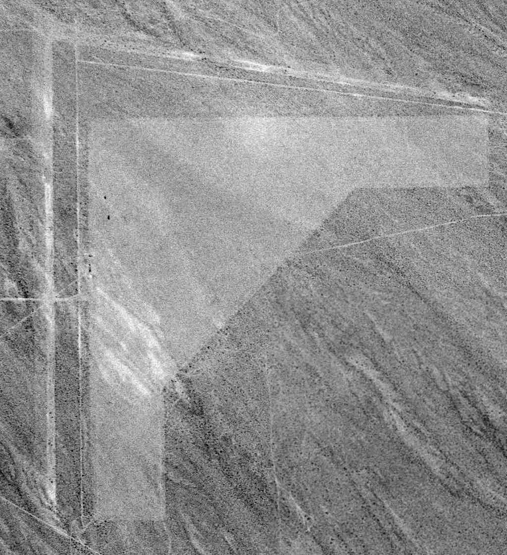
A 1995 USGS aerial view looking northeast at the remains of the Camp Goffs AAF runway.
Photo of the airfield while open has not been located.
At the outbreak of WW2, the town of Goffs was a small railroad station located on the Atchison, Topeka & Santa Fe mainline,
and adjacent to a 1930s alignment of US Route 66.
The Goffs Campsite was established in 1942.
It was part of the 12 million acre Desert Training Center, established to train the armored forces of General George Patton.
Unlike other, more substantial camps of the DTC, the Goffs Campsite was a small, improvised field encampment.
It consisted primarily of the Goffs Railhead, with a surrounding encampment,
the Goffs Army Ammunition Depot #4, and the Goffs Rifle Range.
A 1998 Army Corps of Engineers report on Camp Goffs includes the statement that
"Goffs also had a 1,500' x 150' sand/gravel landing strip about 2 miles to the east (Army Ground Forces 1943)."
Thus the military evidently established a new airfield at this location,
rather than reusing the much-larger former Goffs Intermediate Field, located only 2 miles to the east.
Chris Kennedy supposed, “I doubt it was used by anything other than light liaison planes.
Goffs was a small facility compared to the large camps like Coxcomb & Essex.
It was actually a quartermaster depot & not a camp according to the book I have about the California-Arizona Maneuver Area.
There was a siding off of the main railroad line & a series of warehouses.”
The Camp Goffs airfield was not depicted at all on the 1942/44/45 LA Sectional Charts.
The entire DTC was declared surplus in 1944.
The Camp Goffs airfield was not listed among active airfields in the 1945 AAF Airfield Directory (courtesy of Scott Murdock).
Nothing was depicted at the site of the Camp Goffs airfield on the 1956, 1975, or 1984 USGS topo maps.
In the 1995 USGS aerial photo, the outlines of the single unpaved runway at Camp Goffs AAF was still recognizable.
There was no sign of any buildings or other improvements associated with the airfield.
A 2019 aerial view looking northwest showed the Camp Goffs AAF runway to remain recognizable.
A 3/26/21 photo by David Williams of the remains of the Camp Goffs AAF runway left embankment.
David reported, “Desert creosote have fully taken over the runway & the service road leading up to it.”
The Camp Goffs Airfield site is located 1 mile north of the the intersection of Route 66 & Goffs Road.
____________________________________________________
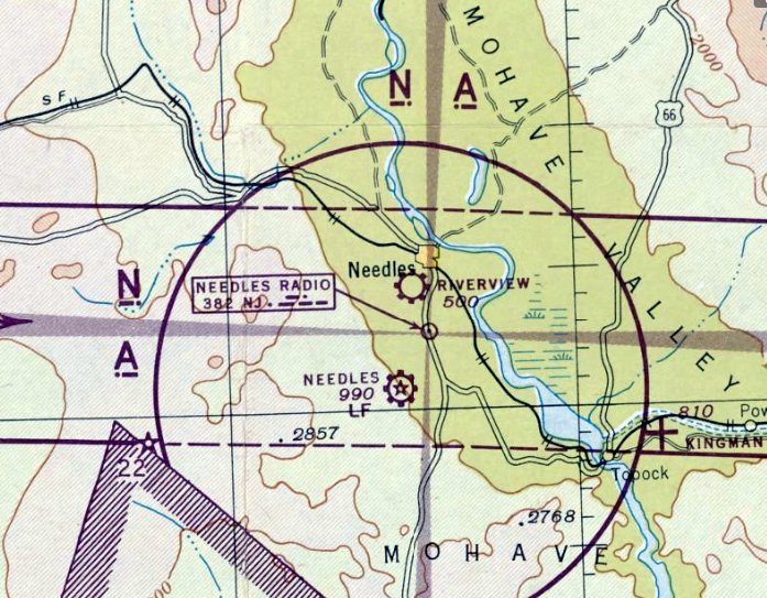
Riverview Airport, Needles, CA
34.82, -114.6 (Southeast of Las Vegas, NV)
Riverview Airport, as depicted on the February 1946 Los Angeles Sectional Chart.
Riverview Airport was not yet depicted on the August 1945 LA Sectional Chart.
According to a list of Southern California Airports, Riverview Airport was established in 1946.
It was presumably built as a replacement airport for the town of Needles,
after the town's pre-WW2 Needles Municipal Airport (4 miles south of the town)
was taken over during WW2 as Needles Army Airfield.
The earliest depiction of Riverview Airport which has been located was on the February 1946 Los Angeles Sectional Chart.
It depicted Riverview as a commercial/municipal airport.
The earliest photo which has been located of Riverview Airport was a 10/31/47 USGS aerial view (enhanced by Bill Grasha).
Two light aircraft were visible parked near a building on the east side of the unpaved runways.
The February 1949 Los Angeles Sectional Chart (courtesy of Chris Kennedy) described Riverview as having a 2,700' unpaved runway.
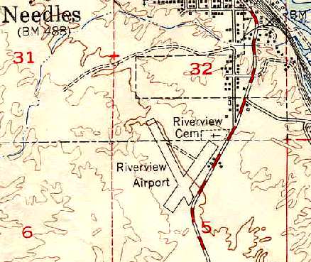
The 1950 USGS topo map (courtesy of Chris Kennedy)
depicted Riverview Airport as being located adjacent to the west side of Route 95, one mile south of Needles.
It was depicted as having 2 runways (oriented northwest/southeast & northeast/southwest),
a connecting taxiway, and several small buildings (hangars?) in between the road & the northeast side of the airfield.
The 1963 AOPA Airport Directory (courtesy of Chris Kennedy)
described "Needles Riverview" as having 2 gravel runways: 2,600' Runway 2/20 & 2,300' Runway 14/32.
The airport was listed as offering hangars, tiedowns, minor repairs, and charters.
The operator was listed as Aileen Wilson, a Piper dealer.
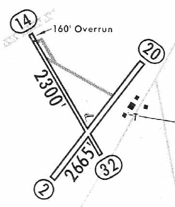
The 1964 Jeppesen Airway Manual (courtesy of Chris Kennedy) depicted Riverview as having 2 dirt runways:
2,665' Runway 2/20 & 2,300' Runway 14/32.
A cluster of 3 buildings was depicted along the east side of the field.
Riverview Airport apparently was closed by May 1964, as a postcard aerial view (courtesy of Rick Jackson)
showed an Army encampment with hundreds of tents surrounding the hangars as part of the massive Exercise Desert Strike.
The last aeronautical chart depiction which has been located of Riverview Airport was on the March 1965 LA Sectional Chart.
It depicted Needles Riverview Airport as having a 2,600' unpaved runway.
Riverview Airport was no longer depicted at all on the August 1965 LA Sectional Chart (according to Chris Kennedy)
or on the 1969 USGS topo map.
It was presumably closed due to competition from the larger facilities at Needles Municipal Airport (to the south).
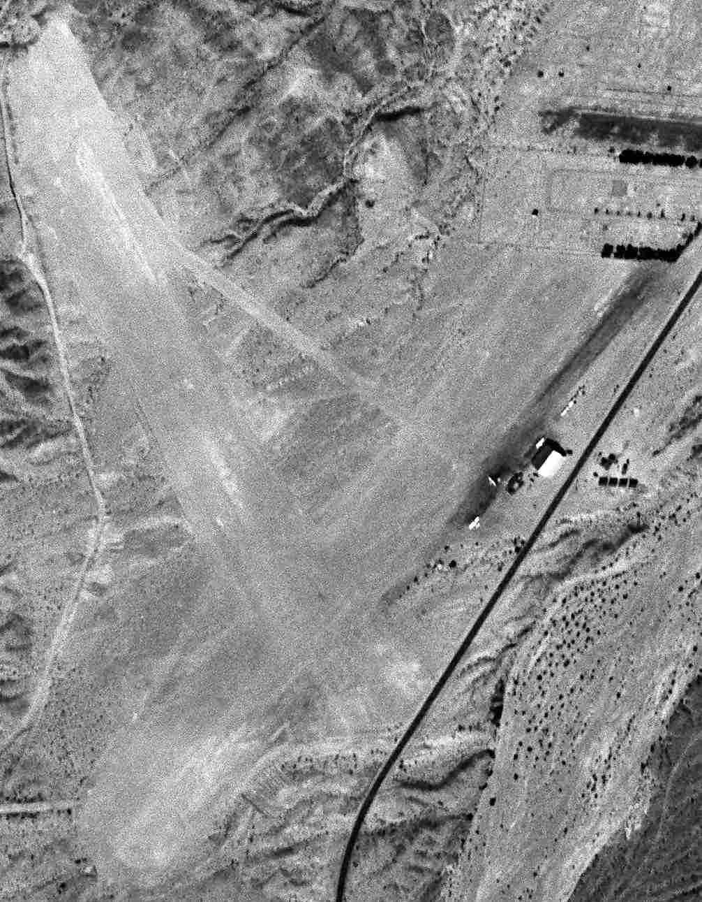
By the time of the 1975 USGS topo map, the airfield of the former Riverview Airport had been covered by several new residential streets.
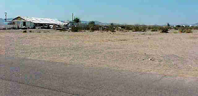
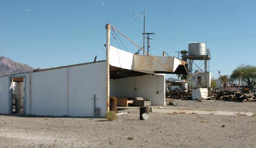
A 5/11/04 photo by John Saunders (enhanced by Bill Grasha) looking southeast across the main runway at the remaining hangar at Riverview Airport.
A 5/11/04 photo by John Saunders (enhanced by Bill Grasha) looking north across Route 66 at the remaining hangar at Riverview Airport.
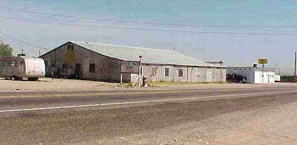
A 5/11/04 photo by John Saunders of "Riverview Needles Airport" still visible on the roof of the hangar.
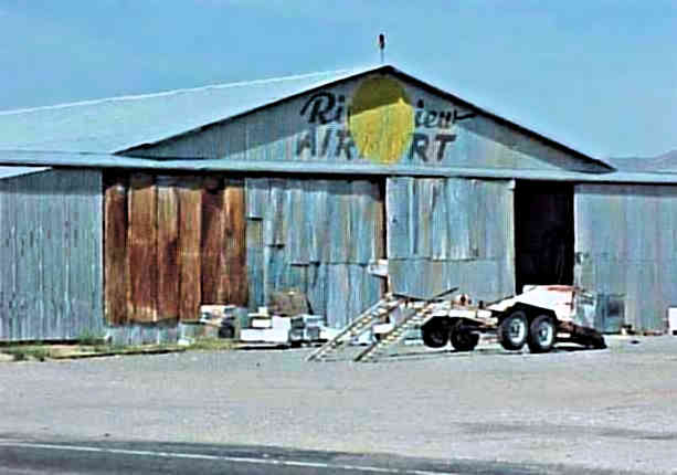
A 5/11/04 photo by John Saunders (enhanced by Bill Grasha) of "Riverview Airport" still visible on wall of the hangar.
John reported, “I had an opportunity to go inside this hangar about 12 years ago & all it was & still is, is a honey processing place for the local bee farms.
I remember a lot of junk laying around, nothing reminiscent of airplanes. The place had shown its age though!
I must say it is old & like the city of Needles, hasn't changed much."
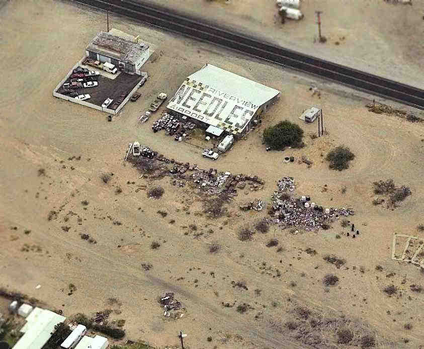
A circa 2006 aerial view looking east (enhanced by Bill Grasha) at 2 buildings which remain standing on the site of the former Riverview Airport,
including the former hangar which still has “Riverview Airport Needles” painted on its roof.
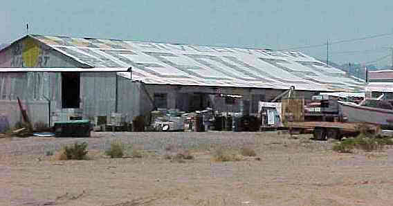
A 2013 aerial view (enhanced by Bill Grasha) showed the area formerly occupied by Riverview's 2 runways had been covered by several residential streets,
but the 2 hangars remained on the northeast portion of the site, along the west side of Route 95.
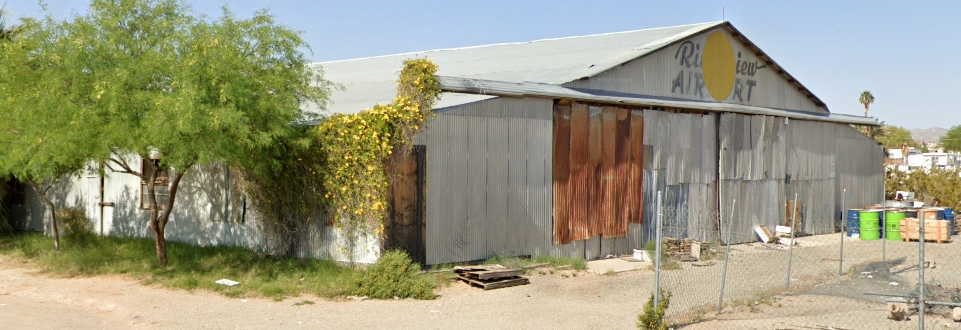
A 2023 photo looking west at the hangar which still has "Riverview Airport" painted over its doors.
Thanks to Chris Kennedy for pointing out this airfield.
____________________________________________________
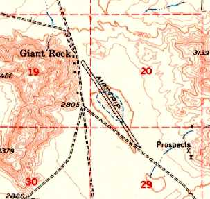
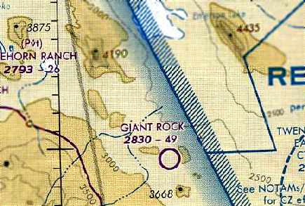
Giant Rock Airport, Landers, CA
34.33, -116.39 (East of Los Angeles, CA)
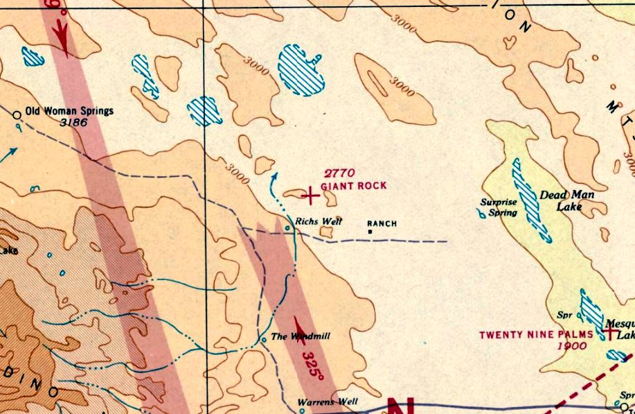
Giant Rock Airport, as depicted on the November 1939 LA Sectional Chart.
The story of Giant Rock Airport begins with Frank Critzer,
a German immigrant who retired to the desert due to chronic asthma
and built an underground home, hollowed out from beneath Giant Rock, in the early 1930s.
Giant Rock Airport was not yet depicted on the December 1938 LA Sectional Chart.
The earliest depiction of Giant Rock Airport which has been located was on the November 1939 LA Sectional Chart,
which depicted Giant Rock as an auxiliary airfield.
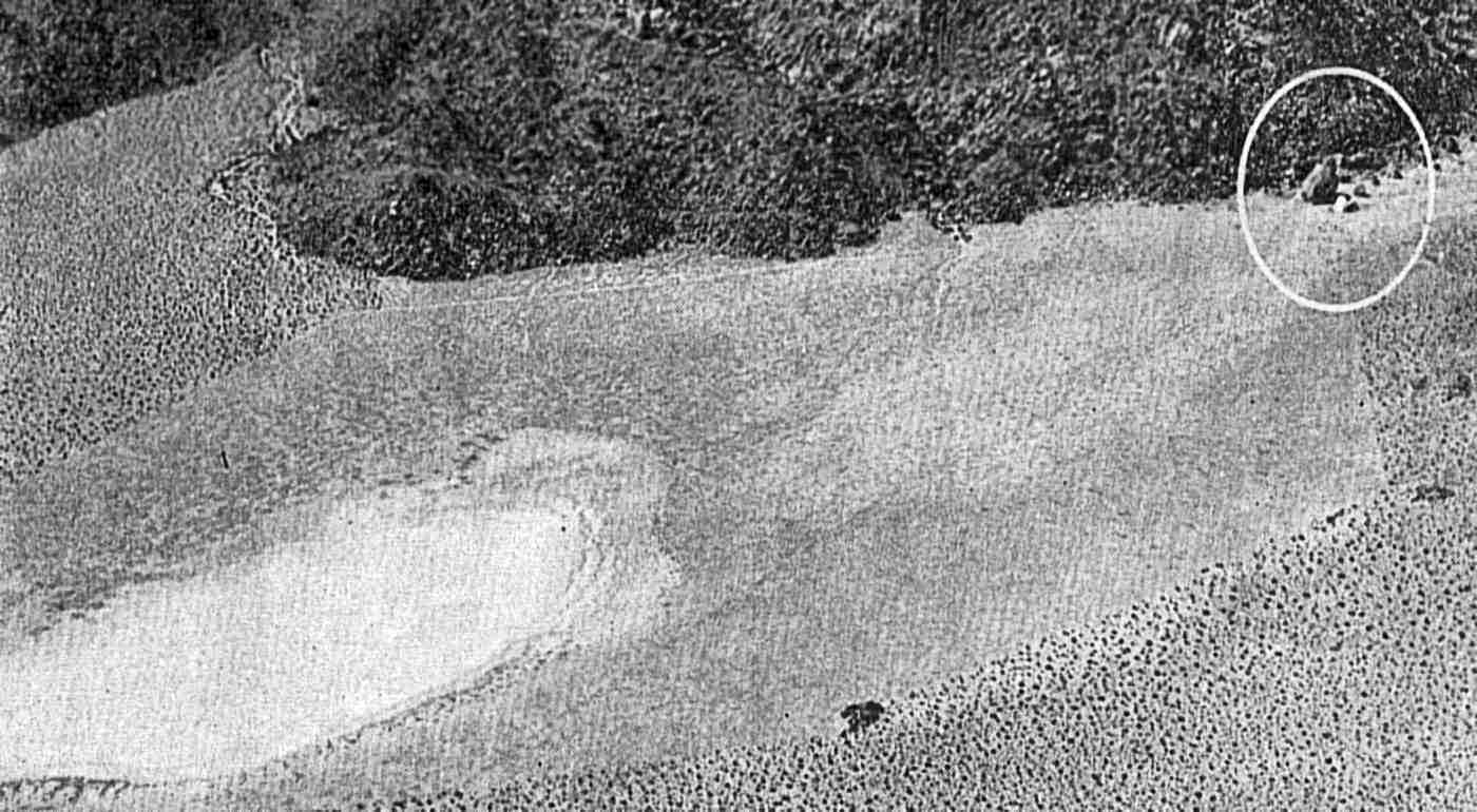
The earliest photo which has been located of Giant Rock Airport was an undated aerial view looking west from a 1942 magazine article (courtesy of Jim Geldert).
The namesake Giant Rock was circled on the right side of the photo, with the unpaved lakebed runway extending toward the bottom-left.
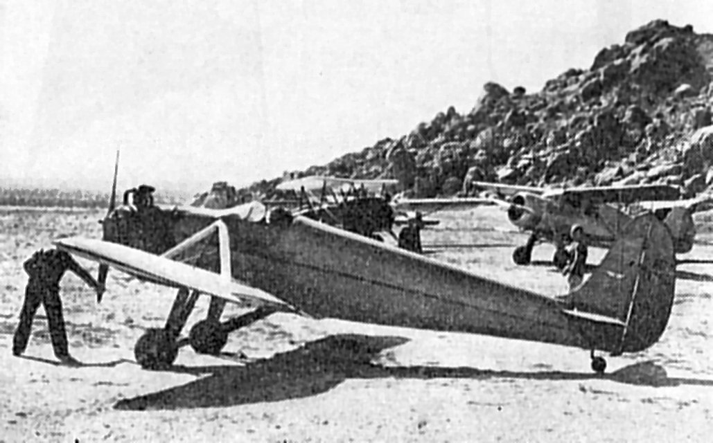
The earliest photo which has been located showing aircraft at Giant Rock Airport was an undated photo of a Kinner monoplane & several other general aviation aircraft
from a 1942 magazine article (courtesy of Jim Geldert).
The article said “The founder of Giant Rock Airport, and friend of many pilots, Frank Critzer, always has a welcome for sky visitors.”
Frank Critzer was killed at Giant Rock in 1942 in the course of a needless showdown with local deputies
who arrived to question him about a rumored affiliation with Nazis.
When Critzer resisted by putting up a barricade,
the deputies threw tear gas canisters into his underground kitchen;
unfortunately it was also where he stored dynamite used for mining ore & he was blown to pieces.
Critzer's Nazi background never checked out;
it was probably the product of a small-town war-time hysterical reaction to his German surname.
In the early 1940s, he introduced George Van Tassel to the Southern California desert scene.
Bloodstains from Critzer's violent death were still on the walls of his underground hovel
when the Van Tassel family moved onto the property.
In 1947, George Van Tassel left his job as a Lockheed aircraft engineer & moved his family to the desert.
He leased 4 square miles from the government, including Giant Rock.
The gutted rooms underneath Giant Rock became storage for the Van Tassel family,
but they slept outside the Rock & during the day tended a small cafe they had set up.
The makeshift runway built by Frank Critzer again became active at Giant Rock Airport.
Van Tassel planned a simple retirement at the early age of 37, running a dude ranch & stopover point for weekend aviators.
In Van Tassel's words, "When the war ended in 1945,
I made application to the Bureau of Land Management to acquire this property, and wanted to make an airport here.
Frank had already cleared an area & many airplanes had landed. However, it wasn't on the air maps
Being of hard decomposed granite, it is a perfect natural runway.
But it was not until 1947 when the paperwork which was involved was finally completed [that] we were able to move to Giant Rock."
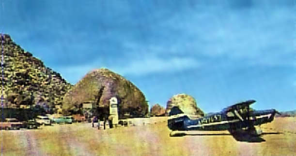
A circa 1940s-50s postcard photo looking northwest (courtesy of Steve Cruse) showed a single Piper taildragger at Giant Rock.
Van Tassel's quiet life changed in 1952 when, he claimed, he began to receive psychic messages from extraterrestrial spaceship commanders.
He eventually built a structure called the Integratron, where he held conventions of UFO enthusiasts.
Phil Du Bois recalled, "My parents visited the 'Giant Rock International Spaceport' in the 1950's.
Of course we kids were present as the adults involved themselves in some strange conversations
with some strange people about aliens, spacecraft, and other issues.
My memories of Giant Rock are vivid, I believe the era was 1952-53, I was 12-13 years old.
I was an airplane nut even then & spent much time at the 'spaceport'.
During the 'Conventions' there were many people present & quite a number of airplanes (10-15 parked on the ramp)."
Jim Long recalled, "My parents had a weekend cabin in Landers.
I visited the airport countless times both when we showed visitors the rock & room below - it had a piano, wood stove, etc.
It was a novelty, and a lost piece of my childhood."
Lane Leonard recalled, “Van Tassel was a Dispatcher for American Airlines in LAX.
My father knew him & we visited there a number of times.
At first the stories were humorous & attracted people to the Airport.
As time went on he became absorbed in them & believed them.”
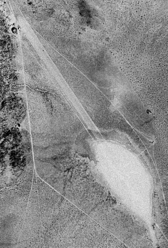
A 5/2/53 USGS aerial photo depicted Giant Rock as having a single northwest/southeast unpaved runway.
The 1955 USGS topo map depicted a single northwest/southeast runway at Giant Rock, labeled simply as “Airstrip”.
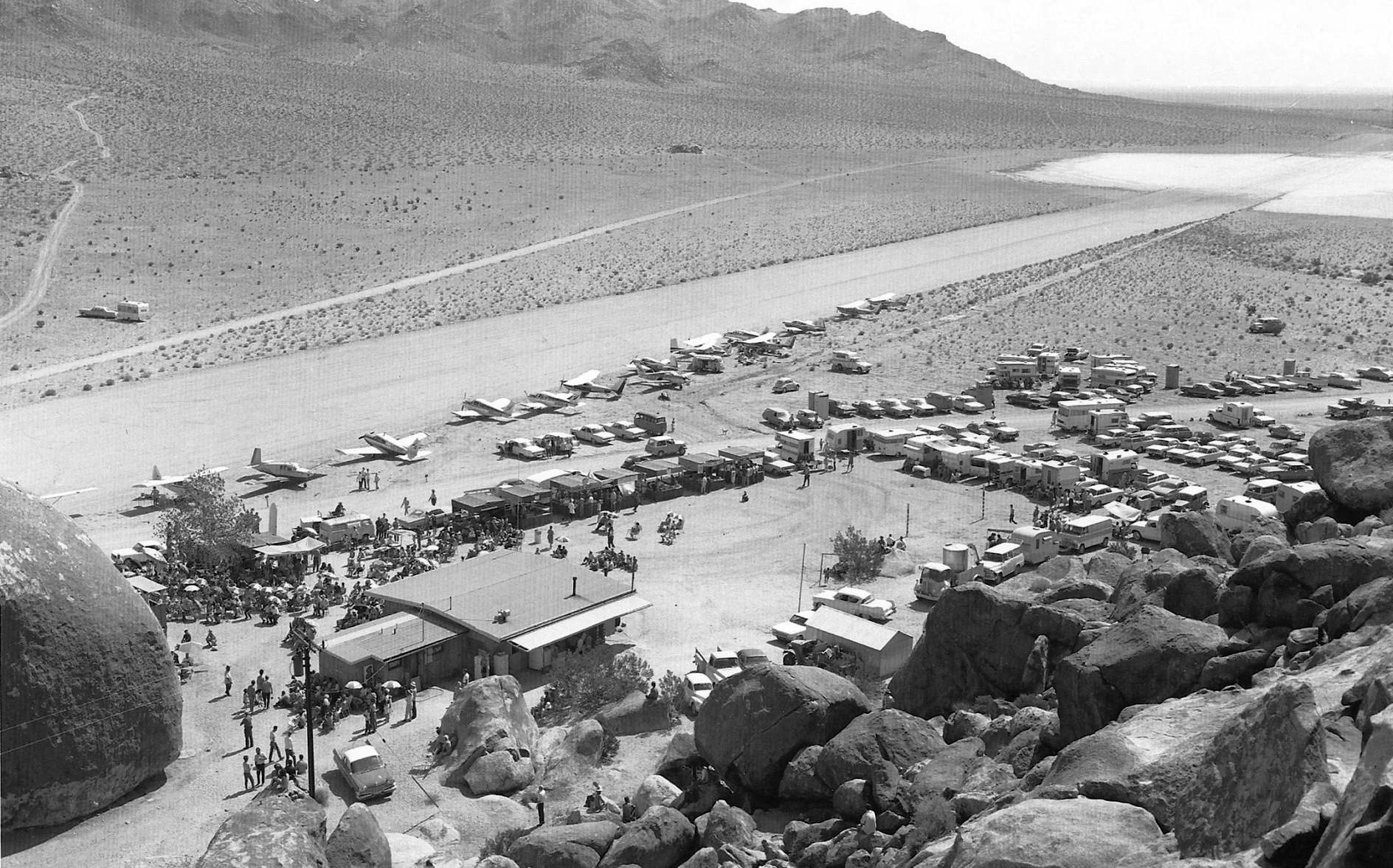
A 1962 photo of a gathering of 16 planes & a large number of spectators at Giant Rock (courtesy of John Acosta).
The Aerodromes table on the 1964 LA Sectional Chart (courtesy of John Voss)
described Giant Rock Airport as having 2 gravel runways, with the longest being 5,680'.
Keith Wood recalled, "My dad flew us to Giant Rock once in about 1968 or 69.
We ate at the café. We toured the house under the rock."
Phil Du Bois recalled, "Many years later I became a pilot & Giant Rock was one of the 1st places I visited.
I flew my Dad to the 'spaceport' in the fall of 1971. The runway was just as I remembered it from my childhood.
The center portion of the runway is actually a dry lakebed.
The runway was extended from either end of the dry lake with (decomposed granite).
The runway was in excellent shape in 1971.
We landed & were surprised to see a sort of restaurant still active on the grounds right next to the 'Rock'.
All that was available was apple pie & soft drinks. Nevertheless, the visit was a memorable one."
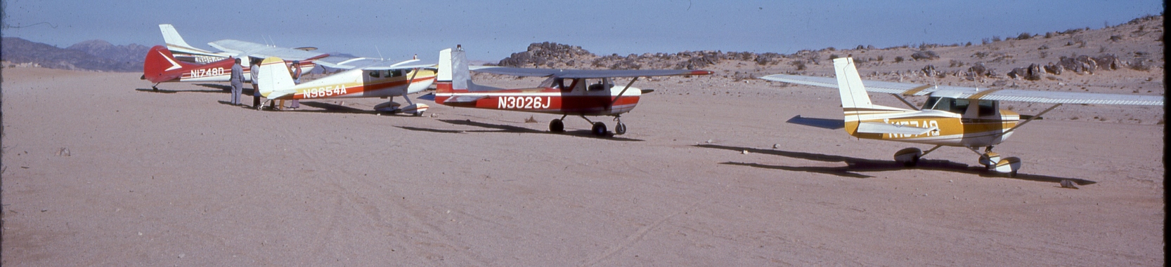
The last photo which has been located showing an aircraft at Giant Rock was a circa mid-1970s photo by Dave Stevens of “a gathering of flying friends”.
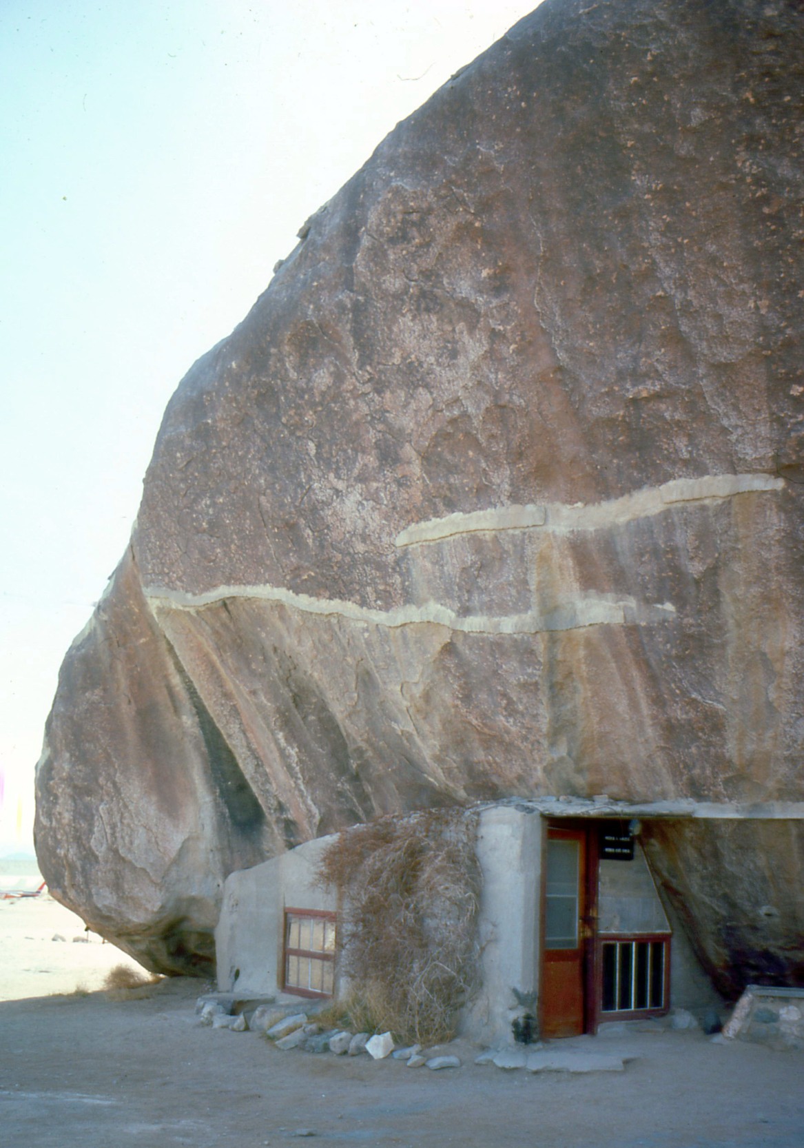
A circa mid-1970s photo by Dave Stevens of the house under Giant Rock.
According to Van Tassel, he operated Giant Rock Airport until 1975,
"at which time I sold it to Phyllis & John Brady, who in turn turned it over to Jose Rodriguez & his family in 1977."
The last aeronautical chart depiction which has been located of the Giant Rock Airport
was on the July 1989 LA Sectional Chart (courtesy of Chris Kennedy).
It depicted Giant Rock as a public-use airport having a 4,900' unpaved runway.
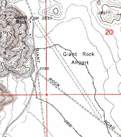
The 1991 USGS topo map depicted Giant Rock Airport as a having a single 5,200' unpaved runway.
As seen in the 1995 USGS aerial photo,
the unpaved runway was still in very good condition, but there was no sign of any recent aviation use.
Phil Du Bois recalled, "I overflew the Giant Rock International Spaceport sometime in 1997.
I dared not land this time. The runway was in ill-repair. No signs of life of any form appeared to me from 200 feet at 100 mph."
Giant Rock Airport was evidently closed (for reasons unknown) at some point between 1989-98,
as it was no longer depicted at all on the 1998 World Aeronautical Chart.
A November 2004 photo by Tim Tyler looking west at Giant Rock.
Tim reported, “It was a pretty rough & bumpy road to get out to the site, and it seems to be a popular area for hard-core off-road racing vehicles.
I was hoping to explore the rooms under the big rock,
but it was quickly clear to me that they'd been back-filled & then had litter tossed into the entrance area over the years.”
A November 2004 photo by Tim Tyler looking east at a foundation at Giant Rock.
Tim reported, “Not much to see besides the Giant Rock itself,
and if you knew a little about the history of the grounds & looked around, you could find the foundation remains of several structures.
The site is close to the Marine Corps Base Twentynine Palms gunnery range.”
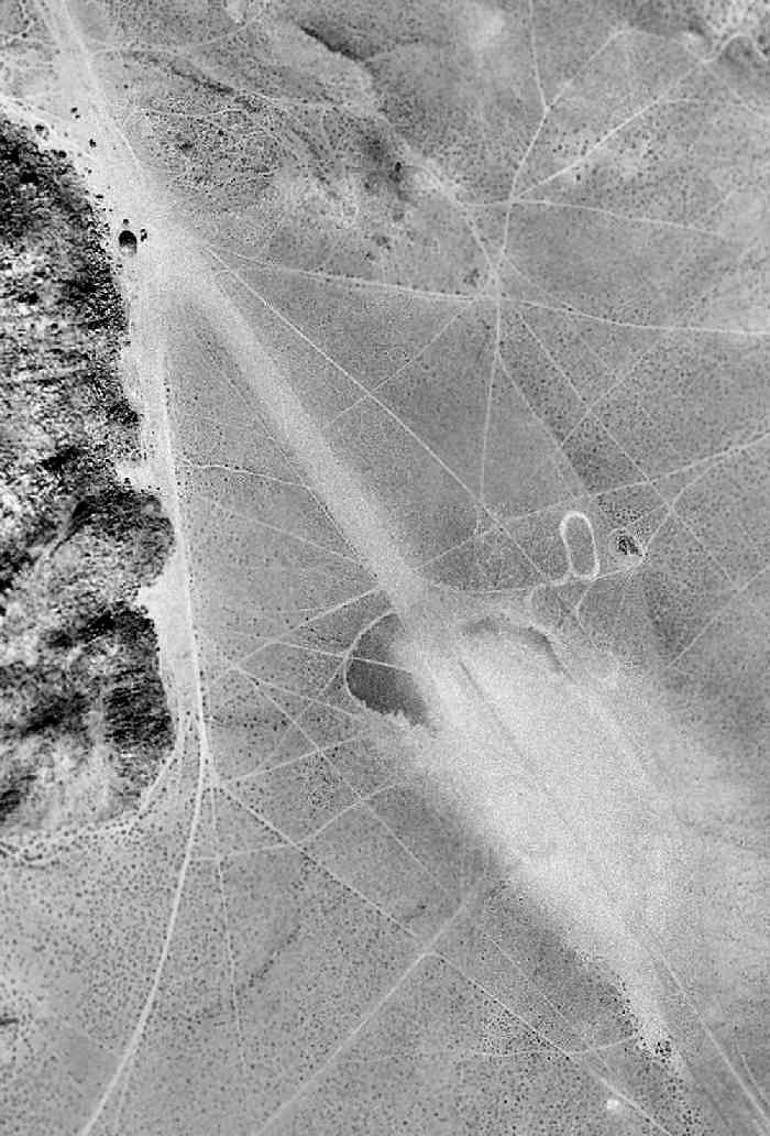
A 10/30/15 photo by Kurtis Clark looking northwest along the Giant Rock runway.
Kurtis reported, “The runway is located partly on a dry lake bed & partly on a slight up-slope towards the rock.”
A 10/30/15 photo by Kurtis Clark (enhanced by Bill Grasha) looking southeast along the Giant Rock runway.
Kurtis reported, “Years of neglect have left the surface unsafe for landing a plane.
People have driven vehicles on the lake surface when it was muddy leaving deep grooves; the up-slope section is covered in bumps (called whoop-de-doos by off-roaders).”

A 10/30/15 photo by Kurtis Clark looking north at Giant Rock & Kurtis' off-road VW Beetle.
Giant Rock Airport is located northeast of the intersection of Giant Rock Road & North Belfield Boulevard, 16 miles north of Yucca Valley.
Thanks to Steve Cruse for pointing out Giant Rock Airport.
See also:
http://www.forteantimes.com/articles/118_rock.shtml
____________________________________________________
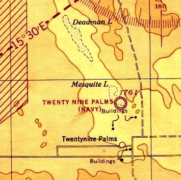
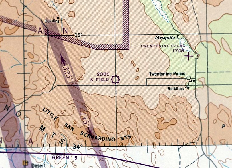
Twenty Nine Palms Airport / Condor Field, Twentynine Palms, CA
34.21, -116.05 (East of Los Angeles, CA)
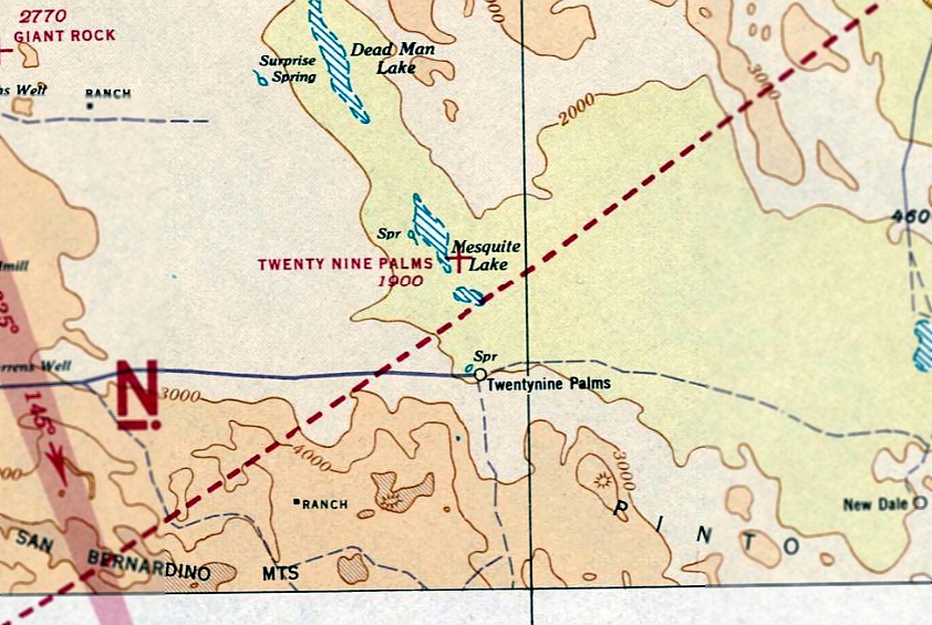
Twenty Nine Palms Airfield, as depicted on the November 1939 LA Sectional Chart.
On the property of the Marine Corps' sprawling Twentynine Palms Air-Ground Combat Center,
its original military airfield is now barely evident.
It was built on the southeast edge of Mesquite Lake, in what is now the Mainside area of the Twentynine Palms Base.
Twenty Nine Palms Airfield was evidently built at some point between 1938-39,
as no airfield at this location was depicted on the December 1938 LA Sectional Chart.
By 1939, a civil field named "Twenty Nine Palms" was depicted on the November 1939 LA Sectional Chart.
In January 1942, the site of the pre-war civil Twenty Nine Palms airfield was reused as the site of Condor Field,
which was established to serve as the primary Army glider school of WW2.
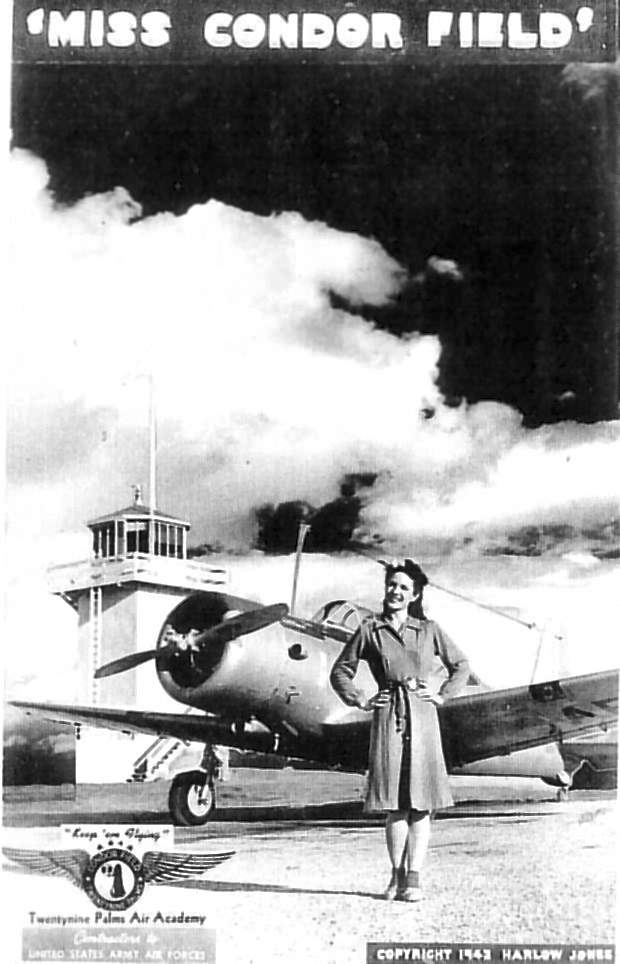
A 1942 photo of “Miss Condor Field” in front of a Vultee trainer,
from a brochure for the “Twentynine Palms Air Academy, Contractor to the USAAF” (courtesy of Joe Matoush).
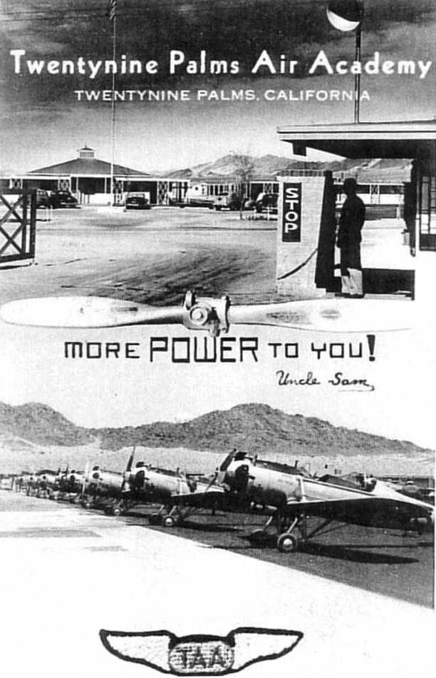
A circa 1942 photo of Ryan trainers at the Twentynine Palms Air Academy at Condor Field (courtesy of Joe Matoush).
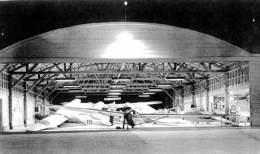
A circa 1942 photo of Schweizer TG-2s gliders inside a hangar at Condor Field (courtesy of Joe Matoush).
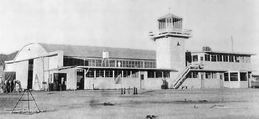
A circa 1942 photo of a hangar with attached control tower at Condor Field (courtesy of Joe Matoush).
The Twentynine Palms Airport (6 miles east) was also used as an auxiliary glider airport by Condor Field during WW2.
A WW2-era photo Roland Bauman (from the Collection of Clark Bauman) of Stearman trainers on the Condor Field ramp.
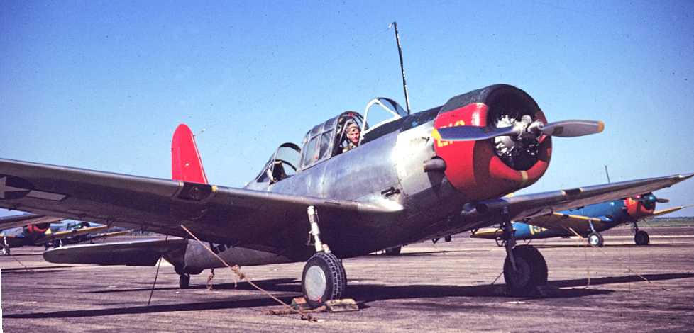
A WW2-era photo by Roland Bauman (from the Collection of Clark Bauman) of a Vultee BT-13 trainer at Condor Field.
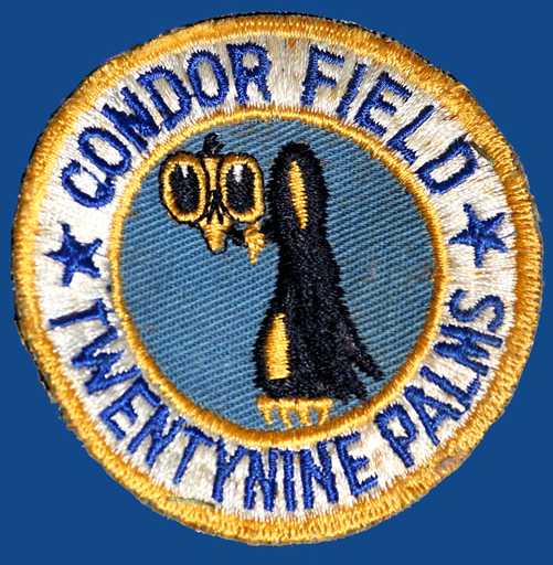
A WW2-era patch of Condor Field (from the Collection of Clark Bauman).
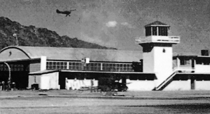
A WW2 photo of a Piper Cub overflying a Condor Field hangar & its control tower.
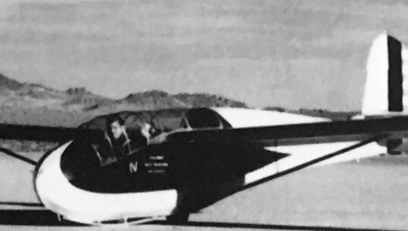
A WW2 photo of a glider (model unidentified) at Condor Field.
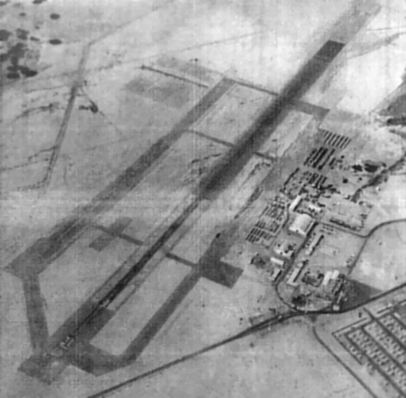
A 7/25/43 aerial view looking north from the 1945 AAF Airfield Directory (courtesy of Scott Murdock)
depicted “Twenty-Nine Palms Naval Auxiliary Air Station (Condor Field)” as having 2 oiled runways.
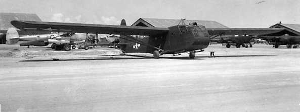
A WW2 photo of a CG-4A glider at Condor Field, with several P-38 Lightning fighters in the background.
Condor Field's mission of training Army glider pilots came to an end in April 1944,
and the Army closed their operation at the field.
"Condor #1, Army" was listed in the 1944 US Army/Navy Directory of Airfields (courtesy of Ken Mercer),
but the remarks said "Closed".
It was described as having a 3,000' runway.
After the Army relinquished the field, it was taken over by the Navy in 1944,
and was redesignated Twentynine Palms Naval Auxiliary Air Station.
It was labeled as "Twentynine Palms (Navy)" on the 1944 LA Sectional Chart (courtesy of John Voss).
The 1945 AAF Airfield Directory (courtesy of Scott Murdock) described “Twenty-Nine Palms Naval Auxiliary Air Station (Condor Field)”
as a 720 acre irregularly-shaped property having 2 oiled runways (3,000' northeast/southwest & 2,500' northwest/southeast),
along with a 8,000' x 2,500' dry lake bed all-way landing area.
The field was said to have 2 wooden hangars, the largest being 200' x 151'.
Condor Field was described as being owned by the U.S. Government, operated by the Navy, but being inactive.
Twentynine Palms Naval Auxiliary Air Station was abandoned by the Navy in October 1945.
At some point between 1945-47, Twentynine Palms was reopened as a civil airport,
as that is how "Twentynine Palms" was depicted on the September 1947 Los Angeles Sectional Chart.
It was depicted as an auxiliary airfield.
The 1949 Los Angeles Sectional Chart (according to Chris Kennedy) depicted "Twentynine Palms" as having a 4,000' paved runway.
In 1952, as part of the Korean War buildup, a need was identified for more expansive ranges to support live-fire training.
Condor Field was determined to be a suitable site,
and the Marine Corps Training Center Twentynine Palms was established on the site of Condor Field.
The airfield at the former Condor Field was expanded as an expeditionary airfield.
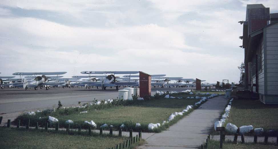
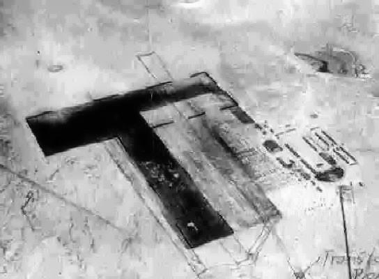
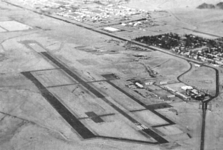
An 11/4/52 aerial view (from the UCSB Library) depicted Condor Field as having 2 parallel asphalt runways, taxiways, ramps,
and a number of buildings on the east side of the field, but there were no aircraft visible on the field.
The 1955 USGS topo map depicted 2 parallel runways, taxiways, ramps,
and a number of buildings on the east side of the field, but it was not labeled at all.
It was labeled as "Twentynine Palms (Marine)" on the 1964 LA Sectional Chart,
and the Aerodromes table on the reverse side of the chart described the field as having 2 runways,
with the longest runway being a 6,000' steel mat.
A circa 1960s aerial view looking west at Condor Field (courtesy of MCAGCC Twentynine Palms MWSS-374 CWO2 John Lackie).
John reported, “A former Marine who served here says that's what it looked like when I was here in 1964.”

The last aeronautical chart depiction which has been located of the original Twentynine Palms Airfield was on the March 1969 LA Sectional Chart.
It depicted “MCALF Twentynine Palms" as having a 6,000' paved northwest/southeast runway.
A 1974 aerial view looking north at Condor Field (courtesy of MCAGCC Twentynine Palms MWSS-374 CWO2 John Lackie),
taken only 2 years before it was replaced by a newer airfield.
Note that the large WW2-era hangar visible in the preceding 1960s photo had been removed at some point prior to 1974.
In 1976, work began to replace the original airfield with a completely new expeditionary airfield,
capable of handling any aircraft up to & including the giant C-5 Galaxy transport.
The new airfield was built 8 miles northwest of the original airfield.
Condor Field was closed in 1976 when the new airfield was opened,
according to MCAGCC Twentynine Palms MWSS-374 CWO2 John Lackie.
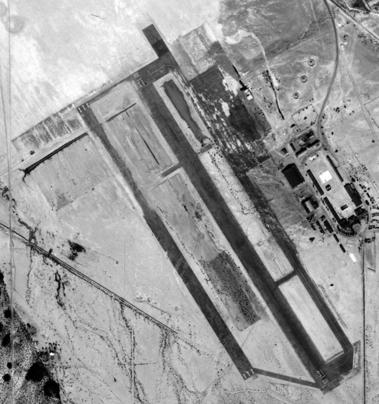
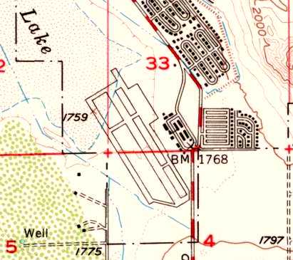
The 1982 USGS topo map depicted the abandoned Condor Field as having a primary runway (oriented northwest/southeast)
as well as a second runway, 3,000' long,
running parallel to the west of the primary runway.
The 1989 USGS topo map depicted the primary runway as being oriented northwest/southeast,
and having a ramp area at the southeast corner.
A 1995 USGS aerial view looking northeast showed the faint outlines of the 2 runways that remained at the site of Condor Field.
A new road had been built through the center of the former runway.
Aaron Gould reported, "I was stationed at Twentynine Palms for a few years
and had the advent to walk out onto the remains of the runway.
It is in very sporadic use (last time I was there) as a landing place for the occasional Harrier jet
and once in a blue moon for helicopters (CH-46s & CH-53s).
Peter Hantelman reported in 2006, “I was in CA this summer [2005], stationed at Twentynine Palms Marine Corps Base.
I lived for 4 months on the trailer park - which was not a few hundred feet from the end of the old runway!
My son found an old sign laying on the ground that described some kind of passenger terminal,
and I couldn't make sense of it at the time.
As I ran on the physical fitness trail (which goes around the northwest end of the field),
I often thought to myself that it sure was flat & smooth, like an old runway. If only I'd known!”
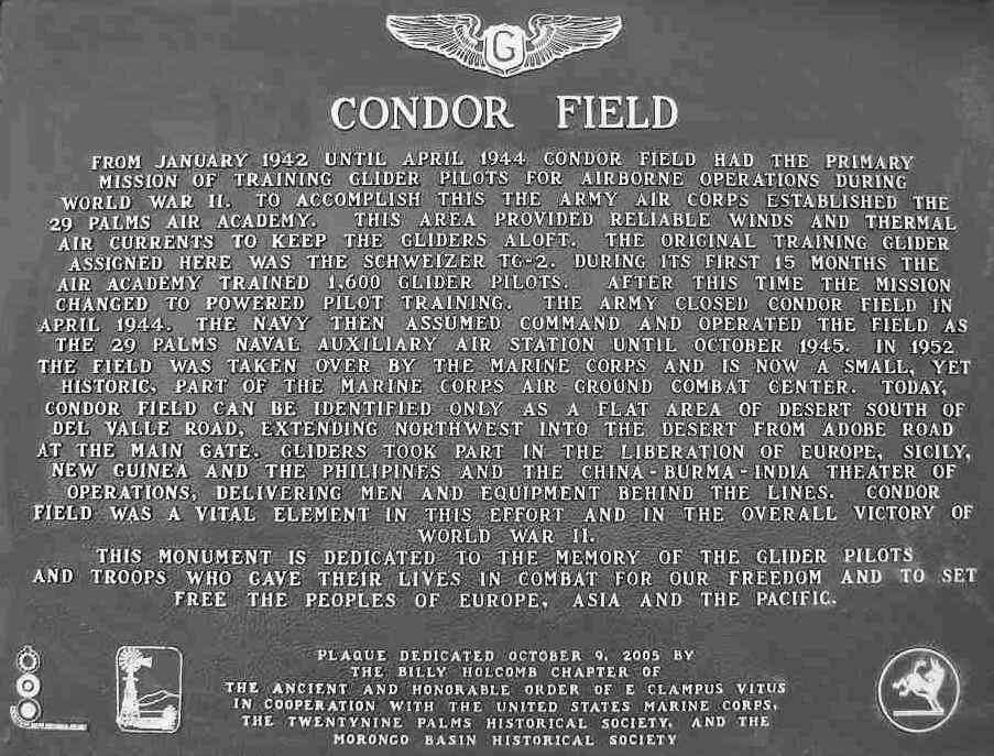
A January 2006 photo of a historical plaque which was dedicated on 10/9/05 at the site of Condor Field (courtesy of Chris Kennedy).
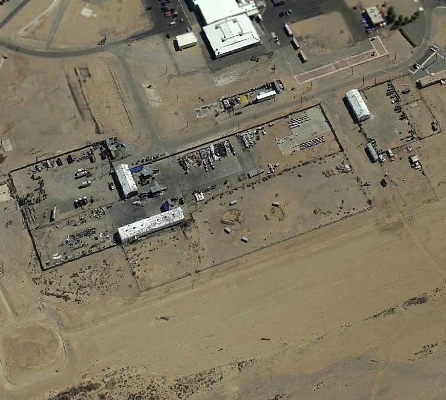
A circa 2006 aerial view looking east at the site of Condor Field
shows several buildings which appear to remain from the WW2 airfield.
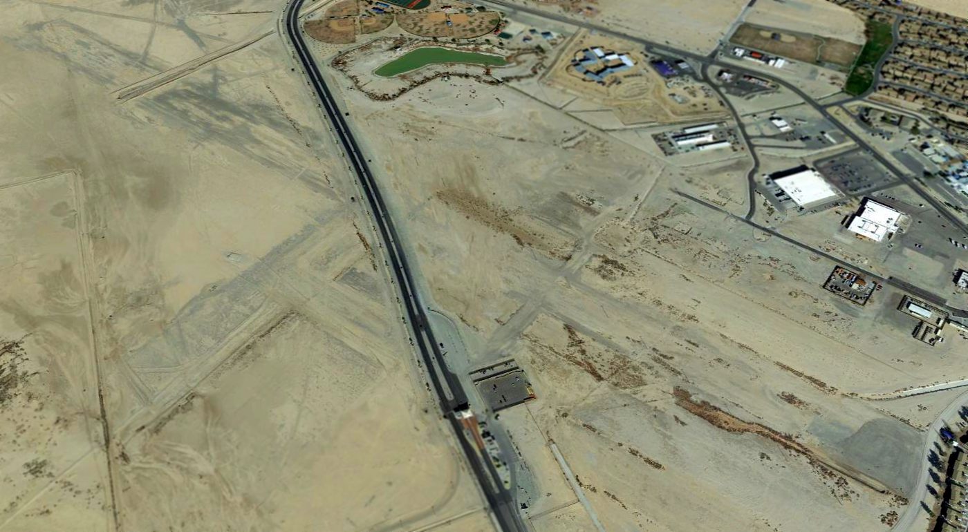
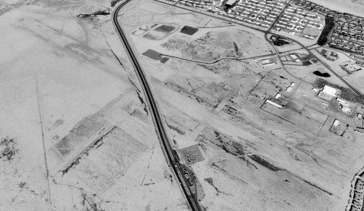
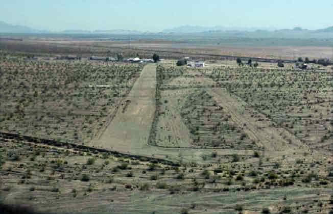
A 2015 aerial view looking northeast showed the faint outlines of the 2 runways remained at the site of Condor Field,
but the former airfield buildings had been scraped away.
The site of Condor Field is located in the southern portion of Twentynine Palms' Mainside area, west of the intersection of Condor Road & Cottontail Road.
See also:
http://www.29palms.usmc.mil/history/mcagcc%20history.html
http://afg-realty.com/morongo_basin/airport.htm
http://www.thesunrunner.com/Stories/AdobeHotel/adobehotel.html
____________________________________________________
Surprise Springs Marine Corps Airfield, Sunfair Heights, CA
34.3, -116.27 (East of Los Angeles, CA)
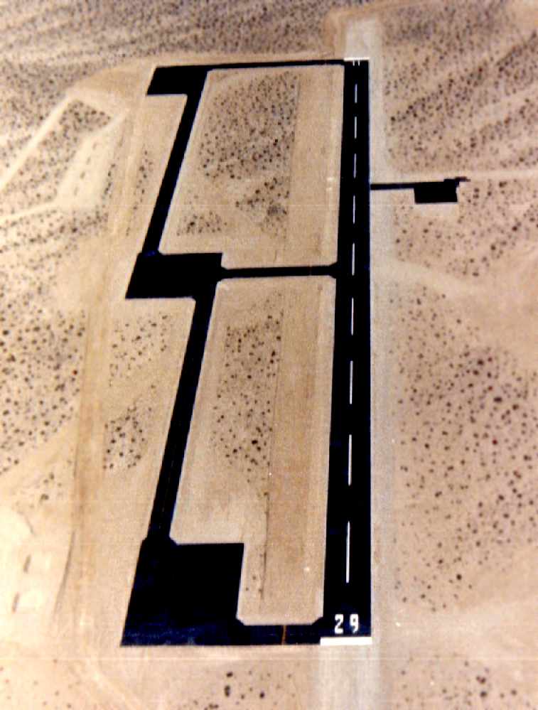
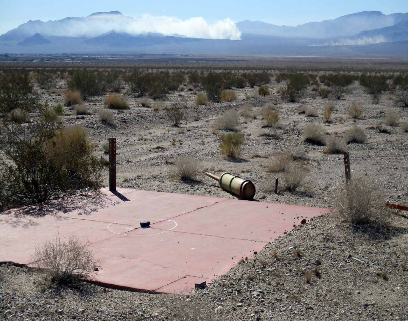
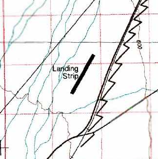
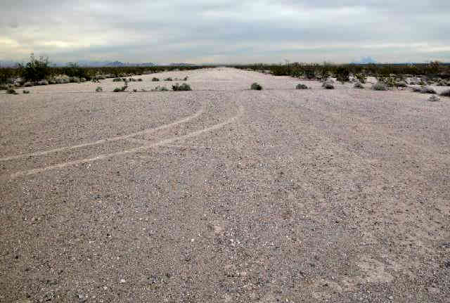
A 1987 aerial photo looking west along Surprise Spring's Runway 29 (courtesy of CWO2 John Lackie).
This military airstrip sits in the desert 6 miles west of the primary Twentynine Palms Expeditionary Airfield.
The airfield was not yet depicted on the 1982 USGS topo map.
According to CWO2 John Lackie, the Expeditionary Airfield Officer for Twentynine Palms Marine Wing Support Squadron-374,
the Marine Corps began operating the Expeditionary Vertical Short Take-off & Landing field in 1985.
It consisted of a 2,000' AM-2 airfield matting runway, along with a taxiway & parking ramps, and 6 refueling berms.
Surprise Springs served AV-8B Harriers & Marine helicopters.
The earliest depiction which has been located of the Surprise Springs airfield
was a 1987 aerial photo (courtesy of CWO2 John Lackie).
It depicted the field as having a single Runway 11/29,
along with a parallel taxiway on the southwest side, along with 4 square ramp areas.
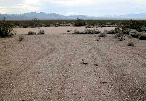
A 7/25/89 USGS aerial view looking north showed Surprise Springs while it was still operational.
According to CWO2 John Lackie, “Surprise Springs was in operation until 1992.
The airfield AM-2 surfacing was not removed until 1992.
The airfield surfacing was pulled up & closed for operations because of environmental reasons.
The airfield was built directly over the natural sub basin groundwater named 'Surprise Springs'.
Environmental fears existed that prolonged use/spills would endanger the water supply.”
A 10/2/95 USGS aerial photo (enhanced by Bill Grasha) shows that the airfield consisted at that point
of a single 2,600' runway, oriented northwest/southeast.
It appeared to be unpaved in that photo (without any steel planking), presumably after it was abandoned.
Along the south side of the runway are 3 rectangular pads, which may have been used for helicopter vertical landings.
The 6 refueling berms were visible on the southwest side of the strip. There were no signs of any buildings at the site.
As of 2004, the published airport facility data for Twentynine Palms Expeditionary Airfield included the following remarks:
"Surprise Springs VSTOL facility immediately west of EAF airport terminal area closed."
As of 2004, the airfield at Surprise Springs was not depicted at all (even as an abandoned airfield)
on aeronautical charts or USGS topo maps of the area.

A 2018 aerial view looking north showed the abandoned Surprise Springs Airfield.
The Surprise Springs Airfield is located 2 miles northwest of Surprise Spring Road, and one mile east of Border Road.
____________________________________________________
Camp Coxcomb Army Airfield / Coxcomb Airfield, Freda, CA
33.92, -115.24 (Northeast of Los Angeles, CA)
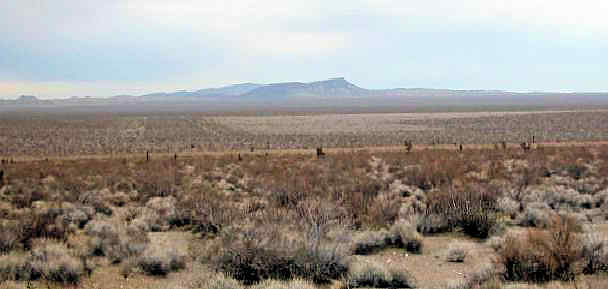
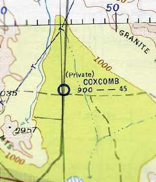
Coxcomb Airfield, as depicted on the September 1951 San Diego Sectional Chart.
Photo of the airfield while open has not been located.
Camp Coxcomb was established in 1942, as one of 10 major Army training camps in the desert which were constructed to train the forces of General George Patton,
as part of the 12 million acre Desert Training Center.
The Camp Coxcomb property consisted of a total of 10,400 acres.
At some point between 1942-44 an airfield was built on the east side of the road (Route 177),
presumably the training operations at Camp Coxcomb (located on the opposite side of the road).
The Army Corps of Engineers history of Camp Coxcomb included no mention of the airfield.
No airfield at Camp Coxcomb was depicted on the 1942/44/45 San Diego Sectional Charts.
The California Arizona Maneuver Area (formerly known as the Desert Training Center) was declared surplus in 1944,
which is when presumably the Camp Coxcomb airfield was abandoned.
No airfield at Camp Coxcomb was depicted on the March 1951 San Diego Sectional Chart (according to Chris Kennedy).
At some point in 1951 the Coxcomb airfield was reopened as a civilian airport,
as that is how it was depicted on the September 1951 San Diego Sectional Chart.
It depicted “Coxcomb” as having a 4,500' unpaved runway.
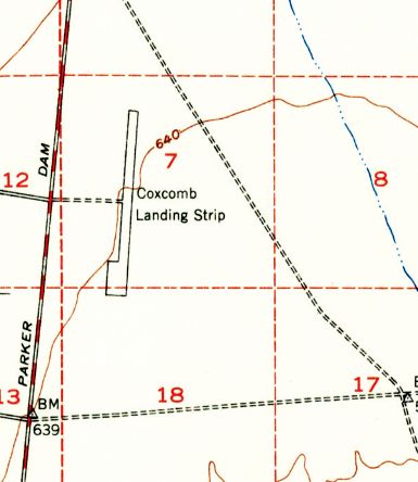
The only topo map depiction which has been located of the Coxcomb Airfield was on the 1953 USGS topo map.
It depicted the “Coxcomb Landing Strip” as having a single paved north/south runway with a paved ramp on the southwest side.
No buildings or other improvements were depicted.
The status of the Coxcomb Airfield evidently changed to a private field at some point between 1952-55,
as that is how it was depicted on the September 1955 San Diego Sectional Aeronautical Chart (courtesy of Chris Kennedy).
The Coxcomb Airfield was evidently abandoned (for reasons unknown) at some point between 1955-58,
as it was no longer depicted at all on the October 1958 San Diego Sectional Chart (according to Chris Kennedy).
Most of the former Desert Training Center camps & airfields were depicted on 1960s USGS topo maps.
However, neither the Camp Coxcomb Airfield nor the surrounding camp street grid is depicted at all
on the 1963, 1969, 1986, or 1987 USGS topo maps of the area.
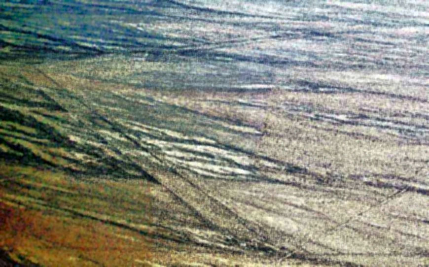
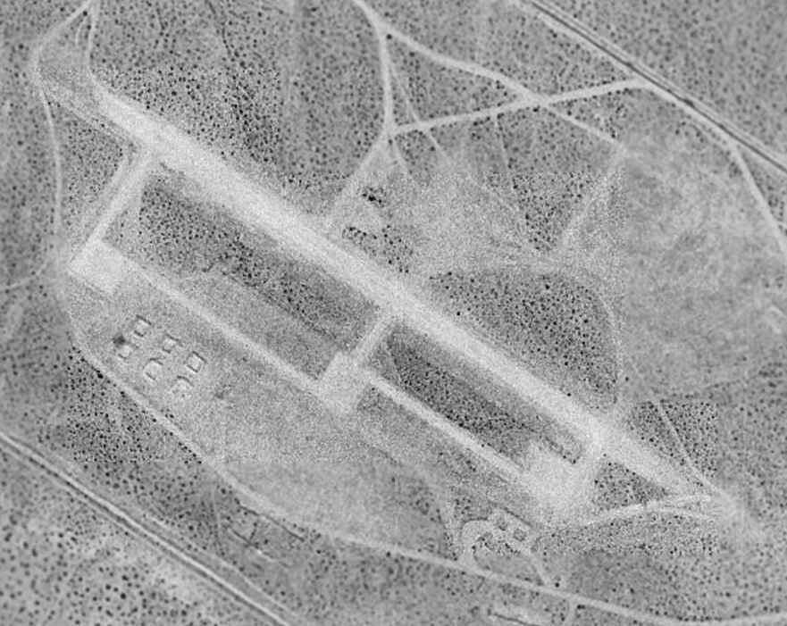
The earliest photo which has been located of the Coxcomb Airfield was a 1977 aerial view.
The outline of the runway was just barely discernible, running north/south, parallel to the highway.
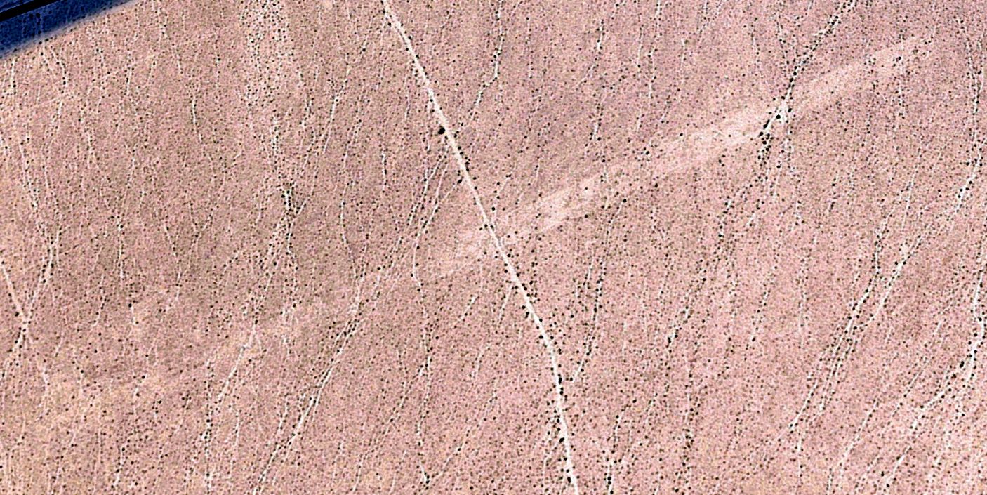
The earliest photo which is available of the Coxcomb Airfield was a 1996 USGS aerial view looking northwest.
The outline of the runway was just barely discernible, running north/south, parallel to the highway.
The Camp Coxcomb airfield was not depicted at all (even as an abandoned airfield) on 2002 aeronautical charts.
Chris Kennedy visited Camp Coxcomb in 2003, and reported that "There is really nothing to identify it as an airstrip.
It's just a slightly lighter section of gravel than the surrounding area."
The outline of the Coxcomb Airfield runway was just barely discernible in a 2023 aerial view looking northwest.
The Camp Coxcomb Airfield site is located along the east side of Route 177, 24 miles southwest of Freda.
____________________________________________________
Camp Essex Army Airfield / Essex Airport, Essex, CA
34.77, -115.22 (Northeast of Los Angeles, CA)
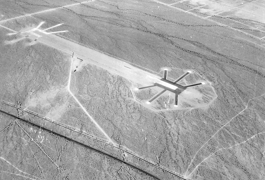
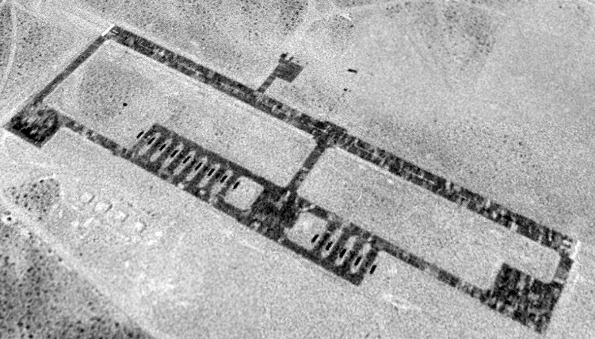
A 7/25/43 aerial view looking west at Camp Essex Airfield (from the National Archives, via Brian Rehwinkel).
In 1942, the success of the German Army in North Africa led the US War Department
to focus Army training efforts in areas with a desert terrain & environment.
The Chief of Staff, General Headquarters, approved of a Desert Training Center
and designated General George S. Patton as the Center's Commanding General.
The total maneuver area encompassed 12 million acres in Southern California & Western Arizona,
making it the largest training area in the U.S.
Close to a million troops trained in this area between 1942-1944.
Within the organization of the Desert Training Center, the Camp Essex site was established as one of the several divisional camps.
In 1943, the Department of the Interior transferred 21,537 acres. An additional 8,998 acres was granted by permit.
The camp was established during 1942 & subsequently occupied by the 93rd Infantry Division among others.
The only permanent structure constructed on the site was a 500,000 gallon concrete reservoir.
No airfield at Essex was depicted on the 1942 LA Sectional Chart.
At some point between 1942-43, an airfield was built to support Camp Essex training operations.
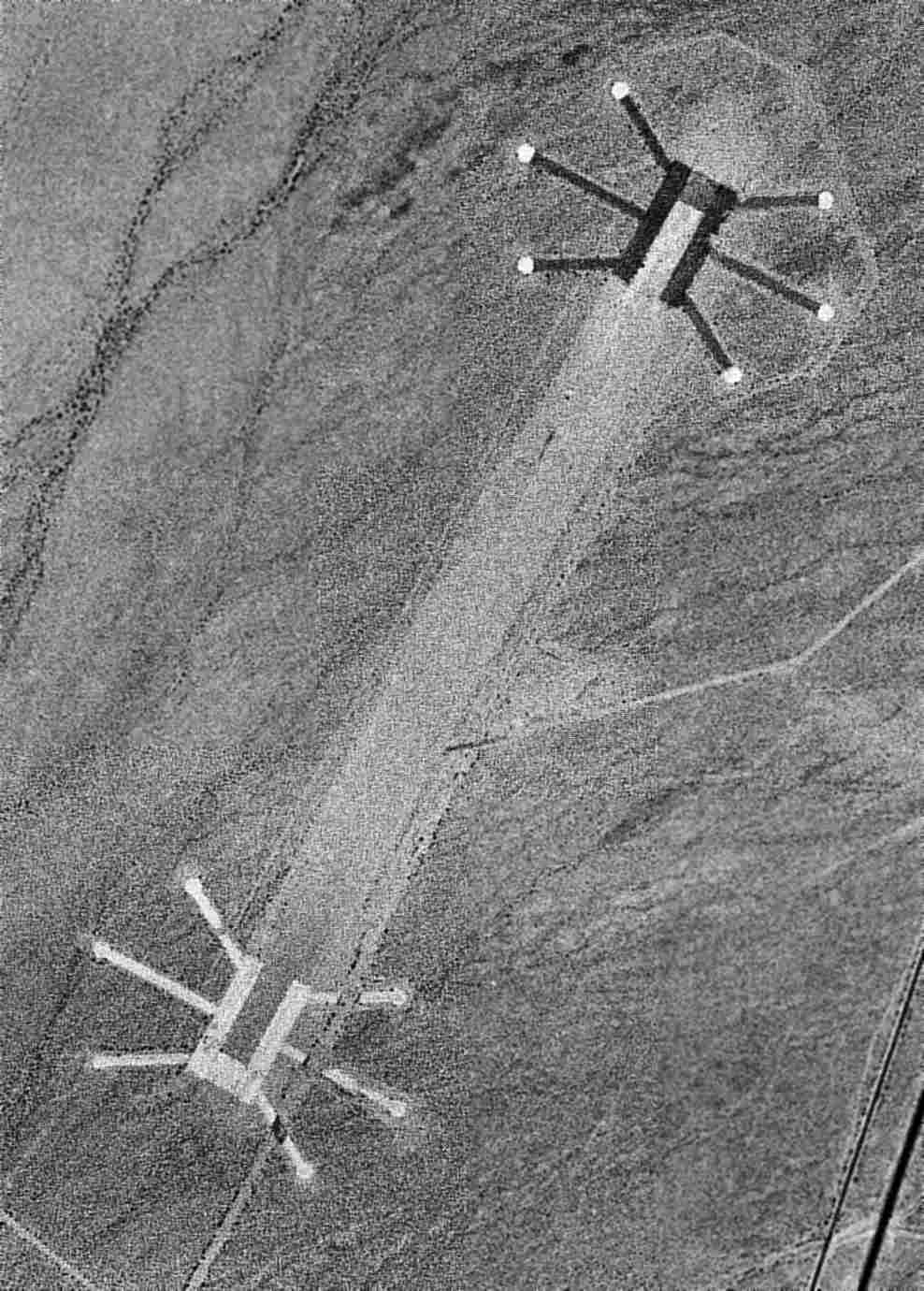
The earliest depiction which has been located of the Camp Essex Airfield was a 7/25/43 aerial view (from the National Archives, via Brian Rehwinkel).
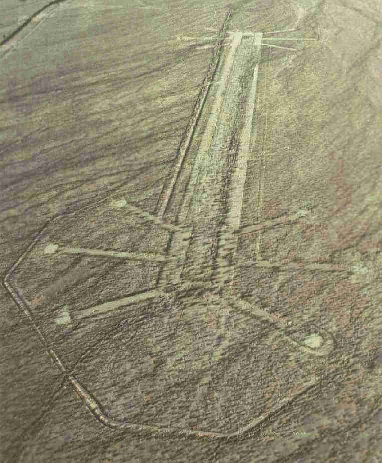
It had a unique configuration, not seen anywhere else, with 6 dispersal pads (?) surrounding each end of a 5,000' northeast/southwest runway.
Brian Rehwinkel reported, “There seems to be some conflicting information on the surface of this field.
I have seen one source that indicates the runways were made up of light rod & bar panels
and another that said the field was compacted (watered) natural surface.
In looking at the [1943] picture – when the airfield was presumably still being used – it does not appear there are rod & bar runways.
Of course, since these planks could be easily removed, it is possible the matting had been removed by the time this picture was taken.”
Camp Essex was declared surplus in 1944.
No airfield at Essex was depicted on the 1944 & 1945 LA Sectional Charts.
In 1945, 21,537 acres were relinquished back to the Department of the Interior.
The Camp Essex airfield was not depicted at all on the March 1950 LA Sectional Chart.
At some point in 1950, the former Camp Essex Airfield was reopened as a private airfield,
as that is how "Essex" was depicted on the September 1950 LA Sectional Chart.
It was described as having a 4,900' unpaved runway.
A 4/23/53 USGS aerial view of Camp Essex Airfield.
The unusual layout of the Camp Essex airfield was depicted on the 1956 USGS topo map,
but labeled simply as “Landing Strip”.
The Essex airfield was was evidently abandoned (for reasons unknown) at some point between 1954-58,
as it was no longer depicted at all on the March 1958 LA Sectional Chart (according to Chris Kennedy).
The Camp Essex airfield was still labeled "Landing Strip" on the 1985 USGS topo map (courtesy of Kevin Walsh).
The Camp Essex airfield was it depicted at all (even as an abandoned airfield) on recent aeronautical charts.
Aerial view of Camp Essex AAF, © 2002 by Larry Dighera.
As seen in 2002, the Camp Essex airstrip & tie-down area were still in good condition.
Fuel cans & the remains of lighting equipment still littered the area.
Keith Wood observed, "The dispersal pads look like they are for B-17s, B-24s or B-29s,
the standard pattern for WW2 forward positioning fields. The 2 runways would permit a mass launch.
The combination of these, the sparse facilities on the field & the location make it likely that this was intended as a fallback field,
supporting March Field in Riverside as well as the Desert Training Center."
A 2003 photo by Chris Kennedy looking roughly north from the south end of the eastern-most runway at Camp Essex.
A 2003 view of an abandoned parking pad at the Camp Essex airfield, by Chris Kennedy.
Chris Kennedy visited the Essex airstrip in 2003, and reported that "There are actually 2 parallel gravel runways,
with the eastern-most one in very good shape for much of its length.
The taxiways to the parking pads are also gravel & mostly in good shape, although a few of them are crossed by a dry stream bed now.
The parking pads at the end of the taxiways appear to be concrete.
I didn't see any remains of buildings, although I didn't do a whole lot of exploring."
See also: http://pirs.mvr.usace.army.mil/fuds/a-d/cmpessex/preasses/inpr/11a.pdf
____________________________________________________
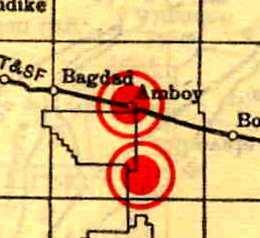
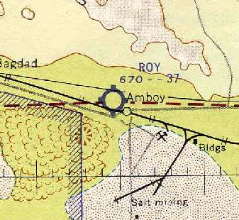
Amboy Airport / Conn Airport / Roy Airport, Amboy, CA
34.56, -115.75 (Northeast of Los Angeles, CA)
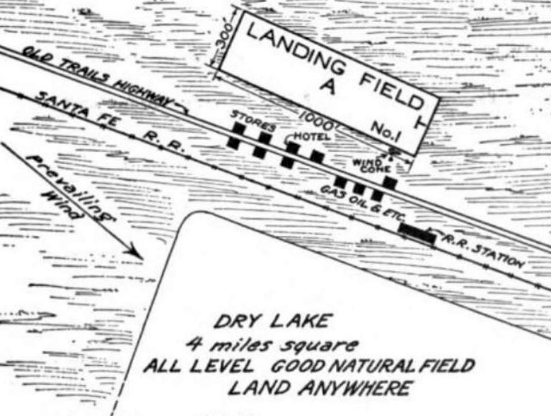
The Amboy Airport, as depicted on the 5/1/25 Commerce Department Airway Bulletin (courtesy of Mike Denja).
Photo of the airfield while open has not been located.
The date of construction of the Amboy Airport has not been determined.
The earliest depiction of Amboy Aiport which has been located was on the 5/1/25 Commerce Department Airway Bulletin (courtesy of Mike Denja).
It described Amboy as a municipal airport, consisting of a 1,000' x 300' gravel rectangular field north of the Old Trails Highway.
A 4-mile-square dry lake to the south of the railroad was also available, “which can also be used except after heavy rains.”
An article entitled “Dedicate Air Highway Over Three States” in the 5/16/25 issue of The Oxnard Daily Courier (courtesy of Kevin Schumann) reported,
“At Amboy not only has an a field been constructed & treated with calcium chloride,
but the name of the town has been painted in huge letters, so that fliers may readily discern their location.”
The Standard Oil Company of California's 1927 "Airplane Landing Fields of the Pacific West" (courtesy of Chris Kennedy)
described the Amboy Airport as a "Permanent" field, measuring 1,750' x 200'.
The Standard Oil Company's 1929 "Airplane Landing Fields of the Pacific West" (courtesy of Chris Kennedy) described the Amboy Airport as "Temporary (small)".
The airfield configuration was said to be "runways 1,750' x 200' west by north."
The 1929 "Rand McNally Standard Map of CA With Air Trails" (courtesy of Chris Kennedy)
described Amboy as a Municipal Airport, operated by M.S. Bender, and measuring 2,640' x 300'.
Amboy was depicted as an auxiliary airfield on the June 1932 LA Sectional Chart.
The Airport Directory Company's 1937 Airports Directory (courtesy of Bob Rambo)
described Amboy Auxiliary Airport as a rectangular 1,400' x 150' sod & gravel landing area.
The Amboy Airport was apparently closed for a few years during WW2
(due to wartime security restrictions, like many other small civil airports during the war).
It was not depicted at all on the 1941 LA Sectional Chart (courtesy of Chris Kennedy).
A minor Army encampment was established at Amboy in 1942 as part of the 12 million acre Desert Training Center.
However, there is no indication that the pre-war civil airfield was reused by the military,
as no airfield at Amboy was depicted on the 1944 LA Sectional Chart (courtesy of John Voss).
Francis Blake reported, "I have never seen any evidence that the runway at Amboy was military.
It certainly could have been used by small military aircraft during WW2,
but I don't believe it was built by or for the military."
No airfield at Amboy was depicted on the 1949 LA Sectional Chart (according to Chris Kennedy).
At some point between 1949-54, the Amboy Airfield was reopened, as "Conn" Airfield.
That is how it was depicted on the 1954 Mojave Desert World Aeronautical Chart (courtesy of Chris Kennedy).
It was described as having a 2,700' unpaved runway.
The airfield in Amboy was depicted as having a single northwest/southeast runway, labeled simply as “Landing Strip”,
with a cluster of small buildings along the southeast side.
At some point between 1954-60, the name of the airfield was changed again, to "Roy".
That is how it was depicted on the 1960 LA Sectional Chart (courtesy of Chris Kennedy),
and was described as having a unpaved 3,700' runway.
It was still depicted as "Roy" on the March 1965 & August 1966 LA Sectional Charts, but the airfield's status had changed to a private field.
Roy Airfield was evidently abandoned at some point between 1966-69,
as it was no longer depicted on the March 1969 LA Sectional Chart.
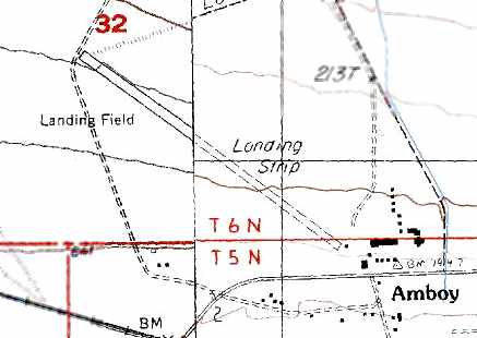
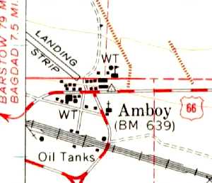
The 1984 USGS topo map depicted Amboy as having a single northwest/southeast runway, labeled as “Landing Strip”.
A 1995 USGS aerial view looking northwest showed Amboy Airport to have a single 4,000' runway.
The runway terminated at its southeastern end right at a small group of buildings,
which are the complete extent of the town of Amboy.
A parallel taxiway ran to the south of the runway, both of which were marked with closed “X” symbols.
A shorter east/west runway extended away from the southeast end of the primary runway.
The airfield at Amboy was no longer depicted at all on the 1998 World Aeronautical Chart.
Like many of the former Desert Training Center airfields in CA,
the Amboy Airport was not depicted at all (even as an abandoned airfield) on 2002 aeronautical charts.
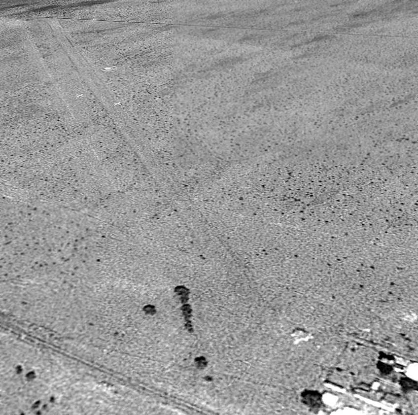
This aerial view looking west at the Amboy airfield, © 2002 by Larry Dighera,
appears to show that the airfield had both a primary runway (oriented northwest/southeast)
as well as a shorter crosswind runway (oriented east/west).
A 2003 view of the Amboy airstrip, looking northwest, by Chris Kennedy.
It was about to rain, which is why the picture is a bit dark.
Bob Jones reported in November 2004, "My friend Gary Lopes & I visited Amboy Airport last Saturday.
I had called about 6 months before, to be sure that it was OK for us to land for breakfast & I was told that it was OK.
The strip was in fair shape. It was only a little rough with only minor washout bumps & some small plants on the strip.
We taxied over near the road & walked over to Roy's Cafe, only to find that it was closed.
The only person that we could find in Amboy was a nice lady working at the post office
who told us that the restaurant is not always open. Indefinite, at best."
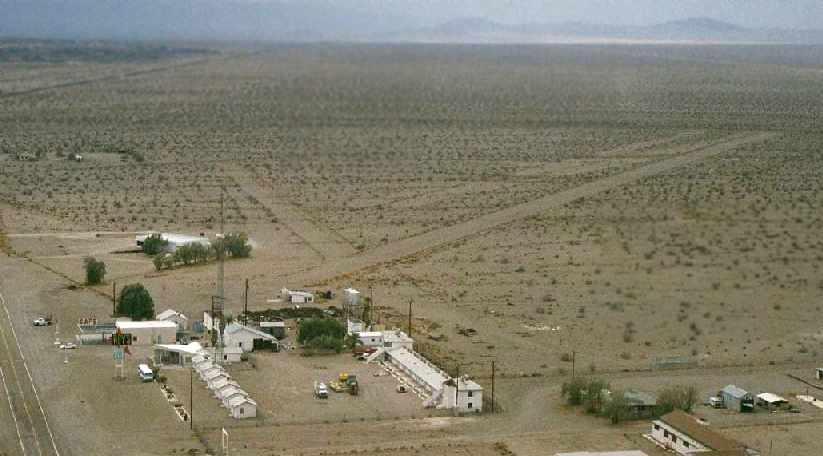
A November 2004 photo by Bob Jones of the T-hangar which remains standing at Amboy.
A November 2004 photo by Bob Jones of his Cessna 182 in front of the buildings at Amboy.
Darrin Smith reported in 2006, “Myself & some friends went through the town of Amboy on motorcycles end of October 2006
and we stopped in & checked to see if the restaurant was open.
It was not so I snooped around a little & ran into a nice guy named Larry.
He said that the health department closed the restaurant down.
The whole town of Amboy has been bought by an investor (Albert Okura, owner of the Juan Pollo restaurant chain) & is in the process of being rebuilt.
Larry is friendly & will entertain you as long as you want.
He said anyone can fly into Amboy if they want to no prior permission required.
I walked the runway because Larry claimed he just had it redone & sure enough it was smooth enough for me.
He said anyone can stay in the hotel for free as it is not open right now & is in need of repair take your cot to sleep on.”
Charles Irvin reported in 2008, “The runways are still fairly clear & the hangar is still in the same condition as it was in the [above] photos,
but Roy's Cafe is closed indefinitely (looks like remodeling).
There's also a cafe in the gas station, but I've never seen the station open,
and there's a hand-written sign in the window that has a phone number for people to call 'for emergency gas'.
A few years ago, some guy bought the entire town
(there's also a newspaper article in the window of the gas station talking about this).
His plans were to restore everything, but I don't know how he's faring.
The school once had a fence around it - now it doesn't,
though it doesn't appear there have been any changes to the buildings, so its possible that the fencing was stolen.”
A 2014 aerial view looking northwest at the Amboy airfield shows the 2 runways to remain intact.
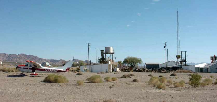
A 2/27/20 photo by Brian Ogilvie looking northwest while on short-final to Amboy's runway.
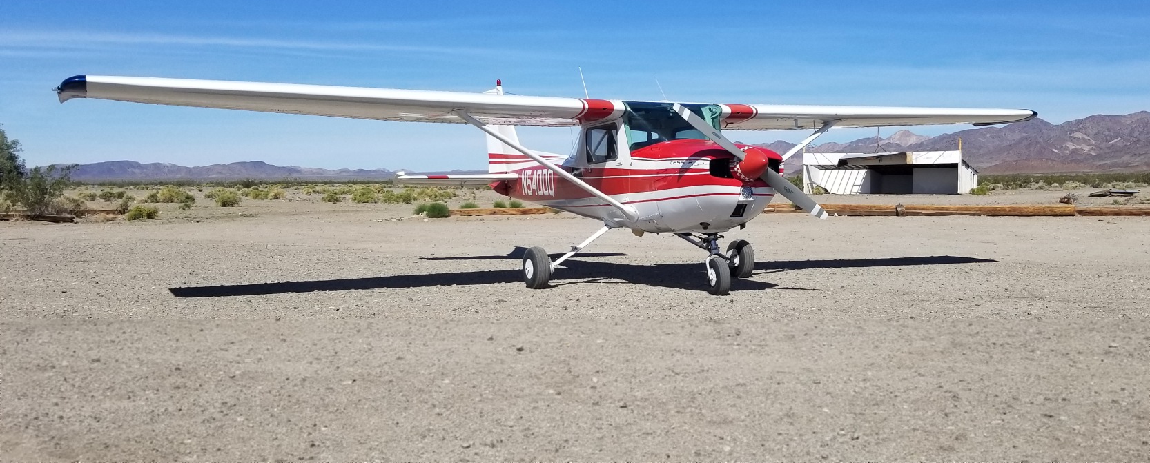
A 2/27/20 photo by Brian Ogilvie of his Cessna 150L at Amboy Airport.
Brian reported, “The windsock is in place; the airfield has been maintained to usable standards.
It is roughly 3,000'x150' usable & in graded & clean condition.”

A 2/27/20 photo by Brian Ogilvie of he & his Cessna 150L at in front of the Roy's Motel Cafe sign at Amboy Airport.
Brian reported, “The town manager, Manny, who operates the gas station & tourist gift shop has really embraced pilots flying in & visiting.
A great stop, just 100NM southwest of Las Vegas & just a short distance east of Twentynine Palms.”
Amboy Airport is located north of National Trails Highway (which was the original US Route 66), at the tiny town of Amboy.
____________________________________________________
Since this site was first put on the web in 1999, its popularity has grown tremendously.
If the total quantity of material on this site is to continue to grow,
it will require ever-increasing funding to pay its expenses.
Therefore, I request financial contributions from site visitors,
to help defray the increasing costs of the site
and ensure that it continues to be available & to grow.
What would you pay for a good aviation magazine, or a good aviation book?
Please consider a donation of an equivalent amount, at the least.
This site is not supported by commercial advertising –
it is purely supported by donations.
If you enjoy the site, and would like to make a financial contribution,
you
may use a credit card via
![]() :
:
Please consider checking the box to make a monthly donatation.
For a mailing address to send a check, please contact me at: paulandterryfreeman@gmail.com
If you enjoy this web site, please support it with a financial contribution.
This site covers airfields in all 50 states.