
Abandoned & Little-Known Airfields:
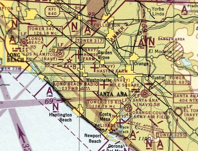
California: Northwestern Orange County
© 2002, © 2023 by Paul Freeman. Revised 8/4/23.
This site covers airfields in all 50 states: Click here for the site's main menu.
____________________________________________________
Please consider a financial contribution to support the continued growth & operation of this site.
For the 8th year, the CA pages of this website are sponsored by the California Pilots Association:
Crawford Airport / Seal Beach Airport / NOLF 21104 (revised 4/12/22) - Cypress School of Aeronautics (revised 7/20/17)
Disneyland Heliport (1st location) (revised 10/15/22) - Disneyland Heliport (2nd location) (revised 3/5/16)
Disneyland Heliport (3rd location) (revised 8/4/23) - East Long Beach / Sunset Beach / Meadowlark Airport (revised 3/27/23)
NOLF 11005 / Haster Farm NOLF / Haster Farm Airport (revised 6/30/22) – NOLF 08303 / Horse Farm NOLF / Horse Farm Airport (revised 4/5/20)
Huntington Beach Airport (1st location) (added 10/16/19) - Huntington Beach Airport (2nd location) (revised 10/16/19)
____________________________________________________
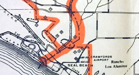
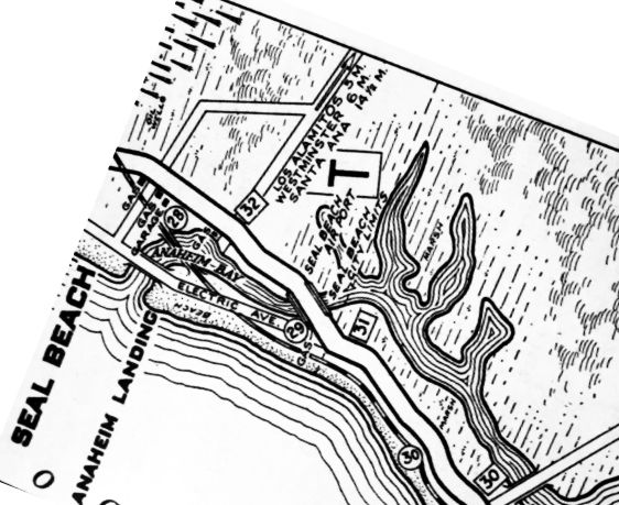
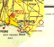
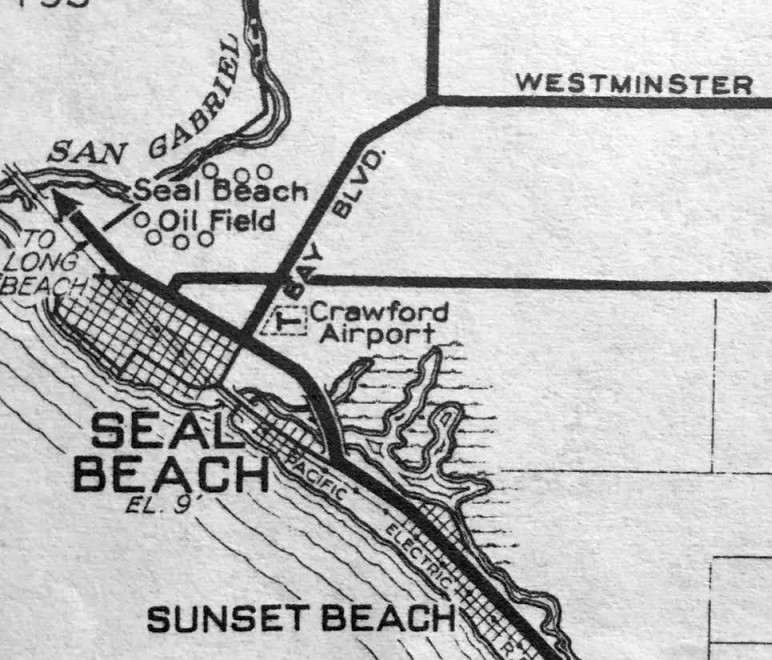
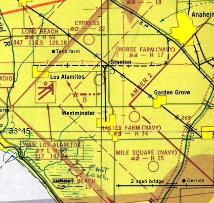
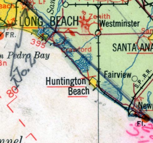
Crawford Airport / Seal Beach Airport / Naval Outlying Landing Field 21104, Seal Beach, CA
33.74, -118.092 (Southwest of Los Alamitos AAF, CA)
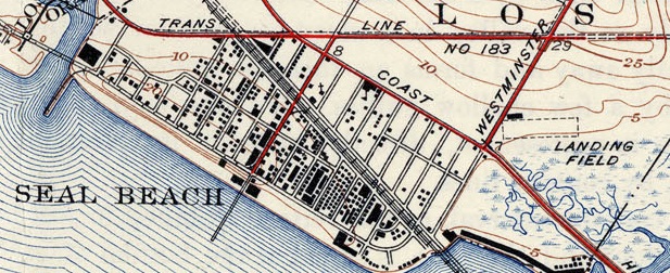
A 1928 aerial view depicted Crawford Airport to have an unpaved east/west runway & a single building on the northwest side.
According to Larry Strawther, “The dirt strip that became Crawford Field was apparently in use as early as 1917
when pilots performing stunt exhibitions over the Seal Beach Joy Zone (it was a short-lived rival to the famous Long Beach Pike from 1916-19) used the strip as a staging area.
In August 1917, C.O. Prest took off from a dirt strip (which was most likely where the Crawford Field is now)
when he set an unofficial altitude record in 1917 & also did mock air battles.
It was apparently also used by Earl Daugherty & other barnstorming pilots when they performed exhibitions in 1919-20.
Many of these were produced under the direction of Wayne Abbott, who had been the Joy Zone’s director of fireworks, lighting, and aerial shows.
Abbott’s son, Harry, who later became a well-known test pilot & first trainer/director of the Nationalist Chinese Air Force – learned how to fly at this airport.
In the early 1920s vague reports & letters in the Long Beach Library allude to unnamed rum-runners
using the Seal Beach airstrip to house a plane they used in rum-running operations.”
In 1927, the L.A. Times reported that Crawford had organized the Crawford Motor & Airplane Manufactory
“to operate an airplane field & school for aviators on the I.W. Hellman Ranch, north of Seal Beach.”
The company was granted a stock-selling permit by the State Corporation Department.
“Other activities of the company will be the manufacture of modern airplanes & motors invented by W.P. Crawford,
head of the corporation & one of its incorporaters.
Crawford has been conducting an airplane business in Long Beach for several years.”
According to Larry Strawther, when Pops Crawford came to the airport in 1927,
an L.A. Times article quoted him as saying “For the past 6 years, he has been trying to secure this location for his plant.”
Larry observed, this “would seem to indicate the dirt strip had been operational as early as 1921.
His new factory neared completion in November 1928, capable of producing 12 / month.”
Crawford was apparently an innovator, and one of the first to place refrigeration on an airplane.
In December 1928, the Hamilton syndicate of Nogales NM ordered 3 planes from the Crawford Airplane Corporation of Seal Beach, to be equipped for refrigeration.
One plane was already under construction, the refrigerator to be operated by from an electrical dynamo generated from the ship while in flight.
“Shrimps which cost 60 cents a pound here, may be had at 10 cents a pound in Chihuahua, Mexico.
The syndicate intends to transport them by plane, speeding up the service, and lowering costs thereby.
If the 3 ships test out successfully, the contract is already arranged, according to factory officials,
whereby 15 more planes will be built under the same principles.”
Either flaws in the idea or the stock market crash of a year later doomed this idea.
In 1928-30 Crawford advertised regularly in Popular Mechanics — offering services in construction of engines, propellers, gliders & blueprints for ice sleds.
They also offered some how-to books, including “Simple Aerodynamics & the Practical Airplane.”
The ads noted the propellers were made for Harley-Davidson, Indian & Heath-Henderson motorcyles.
After February 1929, Air Travel News Volume 3, “the plant was proven inadequate for the volume of business”
and with a $250,000 order from a Mexican syndicate, an enlargement of the plant became necessary.
A report by the Commercial Bank & Trust Company Report, notes that the plant was “recently enlarged.”
A 11/2/29 L.A. Times article mentioned "The William F. Crawford: Airport”, and established Crawford's credentials in the aircraft motor industry.
He also had a good reputation for building propellers & motorcycle motors.
According to Larry Strawther, “Willliam Crawford’s commercial airplane activities seem to have been impacted by the 1929 stock market crash,
and after that gliders seem to have been his main focus.
There is one big article in Flying Magazine – which also pictures his son demonstrating the glider plane, which could be produced for $600.
Other pilots who worked out of the airport & gave lessons were John Tremayne
and E.E. Davis who was also hired by Seal Beach police to act as an air patrol to watch for bathers in distress
and prevent low-flying planes which for the past few years had 'endangered' people on the beaches.”
But Crawford’s airfield apparently also saw some use as a recreational airport.
Pilots from around the area flew there to spend a day at the beach or to give beach-goers short airplane rides for a penny per passenger-pound.
Charles Lindberg, Amelia Earhart, were said to have flown through there.
Seal Beach resident Jim Templeton used to hang around the airport, cleaning planes, talking to the pilots & mechanics, sometimes even receiving free rides.
On one ride, the plane developed engine trouble & landed in the field across from Zoeter School - Jim hopped out, ran across PCH, and was late to school.
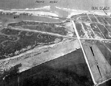
An undated aerial view looking southwest at Crawford Airport from a 1930 airport directory
showed it to have an unpaved east/west runway & a single building on the northwest side.
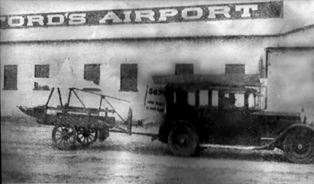
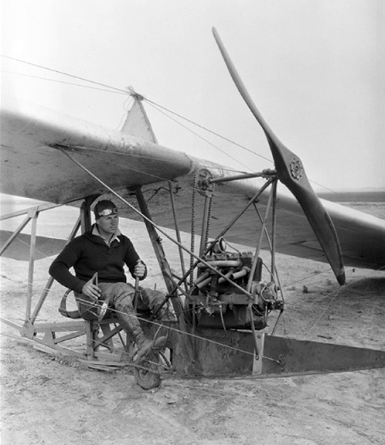
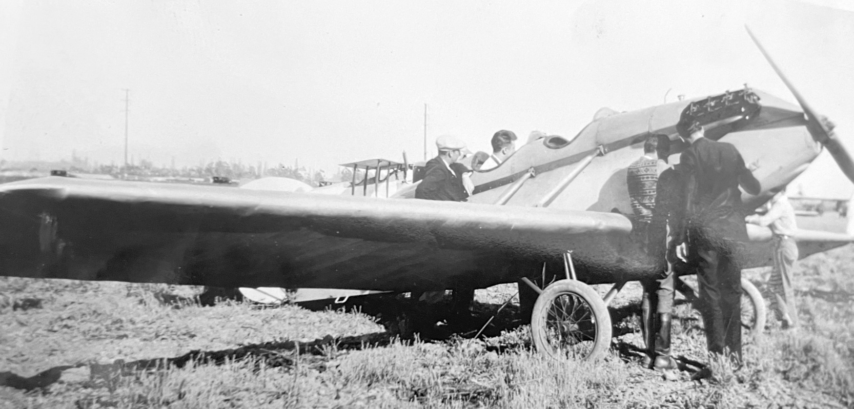
A circa 1930s photo of a glider being towed on a cart in front of a building marked “Crawford's Airport”.
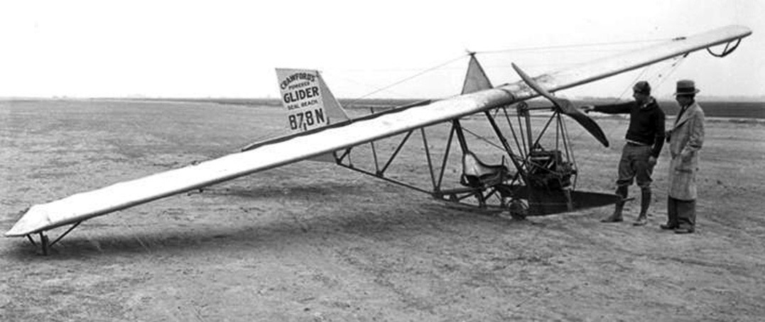
A circa 1930s photo of 2 unidentified people (presumably the pilot is L.R. Crawford) with Crawford's Powered Glider NC878N at Crawford Airport.
Mark Lincoln reported, “NC878N was one of 6; the airplane was built in 1930.”
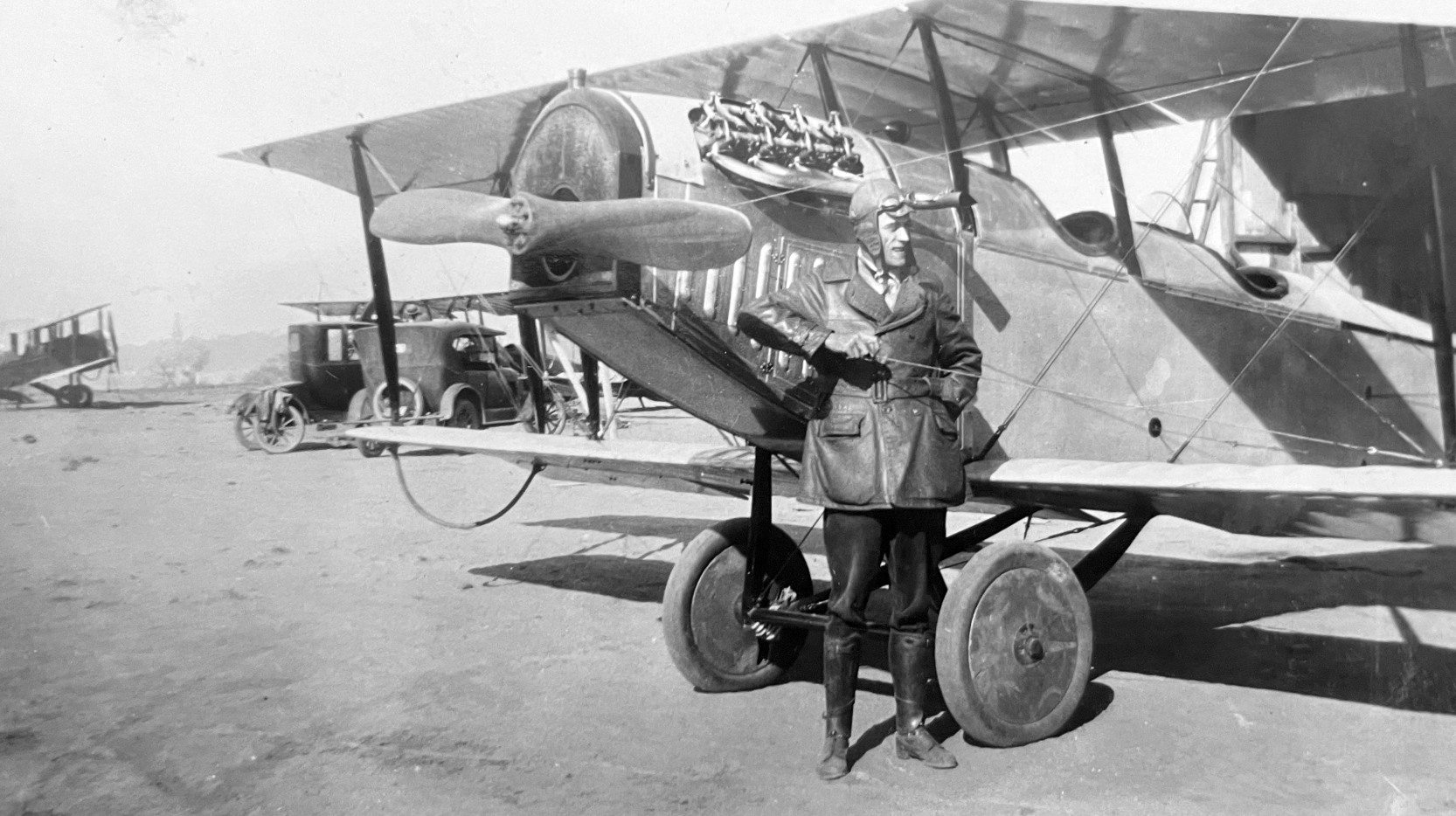
A circa 1930s photo of William Crawford or L.R. Crawford in a Crawford aircraft at Crawford Airport (courtesy of Larry Strawther).
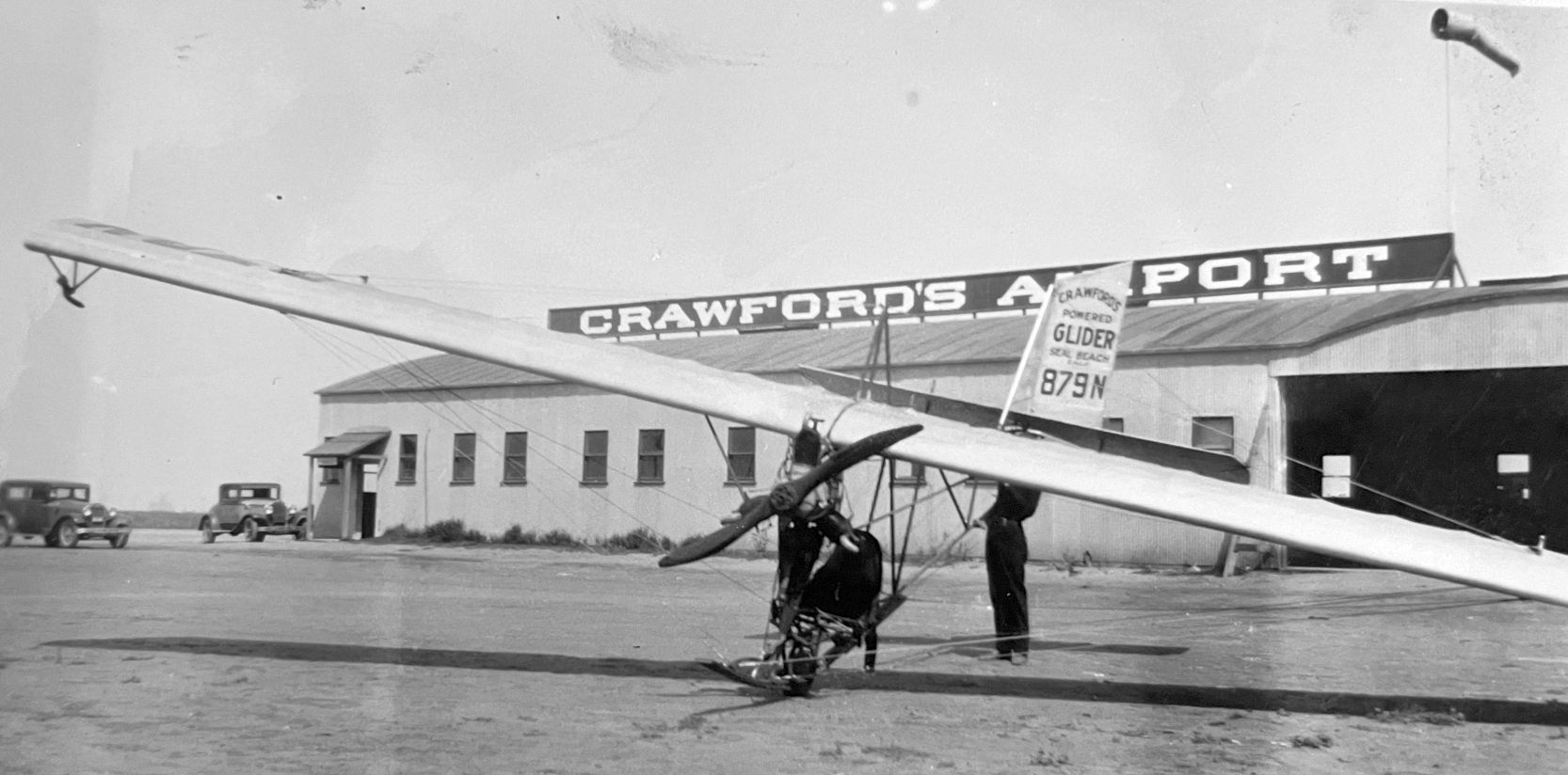
A circa 1930s photo of Crawford's Powered Glider NC879N in front of the Crawford's Airport hangar (courtesy of Katherine Yellen).
A circa 1930s photo of an unidentified pilot & a Jenny biplane at Crawford's Airport (courtesy of Katherine Yellen).
A circa 1930s photo of an unidentified low-wing monoplane at Crawford's Airport (courtesy of Katherine Yellen).
The earliest map depiction which has been located of Crawford Airport was on a 1930 LA County Rand McNally street map (courtesy of Kevin Walsh).
The 1930 "Southern California At A Glance" (courtesy of Kevin Walsh) depicted “Seal Beach Airport' as a rectangular property outline.
Crawford Airport was popular for another reason, too: In 1930 a diner opened across the highway & derived its name from the airport.
The original sign stated: “GLIDE'ER INN & EAT Fish, Steaks, Sandwiches Tamales, Clam Chowder, Chili PRIVATE BOOTHS”.
The brotherhood of fliers began using the inn as a sort of lodge hall. Clark Gable & many other celebrities ate there.
Inside, aviation memorabilia covered the walls & model airplanes hung from the ceilings & the "world's largest hand-carved propeller" decorated the bar.
A sign was mounted beside the sit-down counter: "All aviators are requested to sign our pilots register".
Other pilots flew there to spend a day at the beach or to give beach-goers short airplane rides for a penny per passenger-pound.
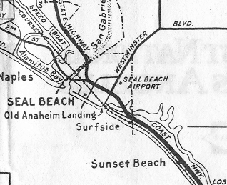
A 1931 map labeled the Seal Beach Airport on the east side of Westminster Boulevard.
Larry continued, “In July 1931 Crawford had Southern California’s first air speed course (the nation’s second) certified along Ocean Ave (Coast Highway) just east of Crawford Field.
Three kilometers long with 500-meter approaches at either end, and flag-topped checkered pylons marking the ends of the straight speedway.”
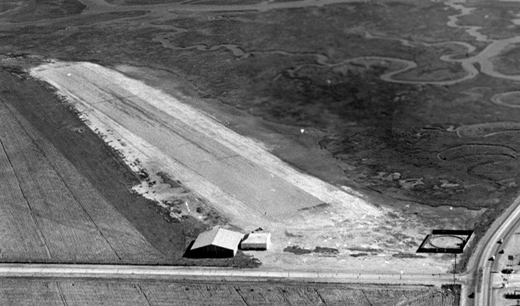
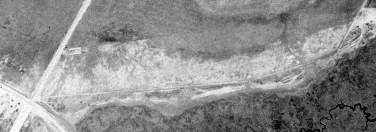
A circa 1930s U.S. Navy aerial view looking southeast at Crawford Airport, with Seal Beach Boulevard in the foreground.
The field had a single unpaved east/west runway, with 2 small hangars on the northwest side.
There were no aircraft visible on the field.
What was the strange enclosed square & circle structure at the intersection with Pacific Coast Highway?
The earliest aeronautical chart depiction which has been located of Crawford Airport was on the 1932 LA Sectional Chart,
which depicted Crawford as a commercial/municipal field.
The 1932 USGS topo map (courtesy of Greg Mosholder) depicted Crawford Airport as an unpaved east/west runway, labeled simply as “Landing Field”,
with a single building on the northwest side.
Crawford may have shut down his shop, because the 1932 issue of Air Commerce Bulletin #4
said “Crawford Airport, 1/4 of a mile northeast of Seal Beach, is no longer available for the use of aircraft.”
A circa 1935-36 street map (courtesy of Kevin Walsh) depicted Crawford Airport as a property outline.
Larry continued, “By the mid-1930s all Crawford Field/Seal Beach Airport operations had been taken over by Wes Carroll & Clyde Schlieper.
Carroll had charters & both apparently offered lessons.”
Sometime in the 1930s the field began being called the Seal Beach Airport.
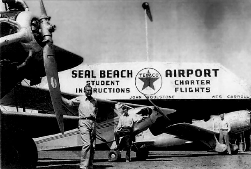
A circa late 1930s / early 1940s photo of instructors in front of Piper & Ryan aircraft & a hangar marked Seal Beach Airport.
According to Larry Strawther, “A June 1940 newspaper article mentions 3 Long Beach Area businessmen
who planned to buy Crawford Field with $200,000 capitalization & totally refurbish it,
including putting in a seaplane landing & specializing in developing flight & speed recording instruments.
This was just after the US Government announced the passage of multiple bills which called for increased military aviation facilities – especially in the Southern California area.
A week or so later, articles mentioned the formation of Columbia Aircraft Associates for development of flight & speed instruments.
But nothing more seems to have come from this plan.”
The 1941 Sectional Chart depicted Seal Beach as a commercial/municipal airport.
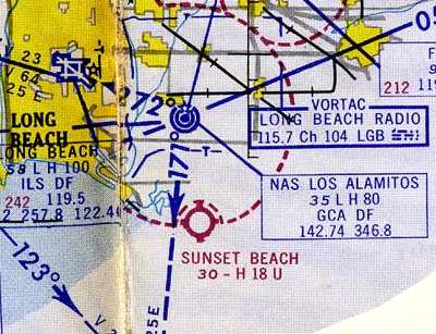
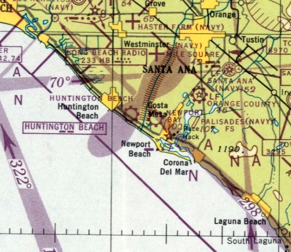
At some point between 1942-43, with the construction of the Naval Air Station just up the road at Los Alamitos,
the Seal Beach airfield was purchased by the Navy & commissioned as a Naval Outlying Air Field
for use by the naval pilots being trained at Alamitos & El Toro.
Its designation of Field 21104 indicated it was on a heading of 211 degrees from Los Alamitos & a distance of 4 NM.
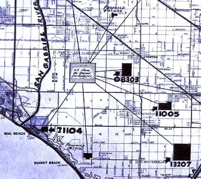
A circa 1943 chart of NAS Los Alamitos & several of its outlying fields (courtesy of John Voss),
including NOLF Seal Beach (21104),
Note that the chart also depicted NOLF 13207 (Mile Square), NOLF Haster Farm (11005), and NOLF Horse Farm (08303),
as well as 2 “proposed” fields which were never built.
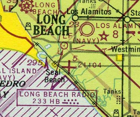
The last depiction which has been located of Seal Beach Airport was on the 1943 Sectional Chart,
which depicted NOLF 21104 as an auxiliary airfield.
The 1943 USGS topo map no longer depicted Seal Beach Airport.
Seal Beach resident Lynne Pranter Phipps recalled, at the time it was at the Seal Beach Airport,
the Seal Beach Airport Administration building had a big letter “R” on the front of the building.
When the Seal Beach Weapons Station came in 1944 the Seal Beach Airport Administration building was moved to the corner of 8th & Central,
across from the Seal Beach City Hall where it became the Ration Board during the war.
NOLF Seal Beach was evidently no longer in use by 1945,
as it was no longer listed among active airfields in the 1945 AAF Airfield Directory (courtesy of Scott Murdock).
A 1952 aerial view showed the site of Seal Beach Airport covered by Navy buildings.
According to John Voss, “Nothing remains of this former Navy airfield as NWS Seal Beach was built up & recommissioned in 1962.”
A 4/16/13 aerial view showed Navy buildings covering the site of Seal Beach Airport.
But a possible remnant is located on the western edge of the site –
could the rectangular concrete feature along Seal Beach Boulevard be the foundation of the Seal Beach Airport hangar?
The site of Seal Beach Airport is located east of the intersection of Seal Beach Boulevard & Pacific Coast Highway.
____________________________________________________
Disneyland Heliport (1st location), Anaheim, CA
33.811, -117.916 (Northeast of Long Beach, CA)
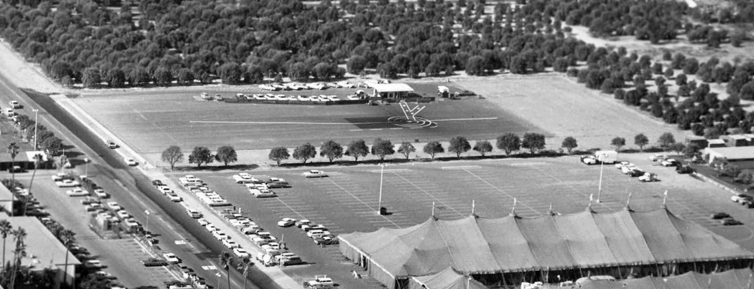
A circa 1955-56 aerial view looking northwest (courtesy of Donald Ballard) showing the 1st Disneyland Heliport,
the asphalt area in the center-foreground with the characteristic “V”-shaped painted marking also seen on later Disneyland Heliports.
Disneyland was once connected to Los Angeles International Airport
via 15-minute helicopter flights provided on a scheduled route by Los Angeles Airways.
The first location of the Disneyland Heliport was located near the intersection of the 5 Freeway & Harbor Boulevard.
Guests would travel to & from the Disneyland Hotel by tram.
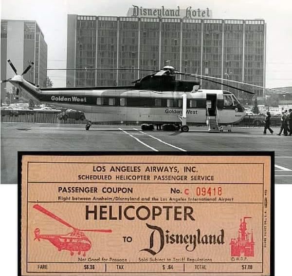
Disneyland Heliport service was initially provided by Los Angeles Airways using piston-engine Sikorsky S-55 helicopters.
Los Angeles Airways had at least 2 S-55s, which were painted green & yellow
(and could seat up to 12 passengers, but probably carried much less in airline service).
The earliest photo which has been located of the Disneyland Heliport was a circa 1955-56 aerial view looking northwest (courtesy of Donald Ballard),
showing the Heliport to be an asphalt area with a characteristic “V”-shaped painted marking also seen on later Disneyland Heliports.
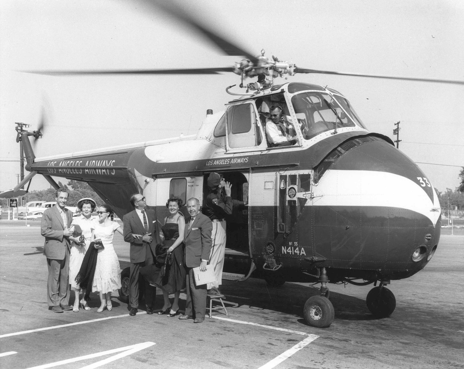
A 1956 photo of guests arriving at the Disneyland Heliport in a Los Angeles Airways S-55 for the Grand Opening of the Disneyland Hotel (courtesy of Don Ballard).
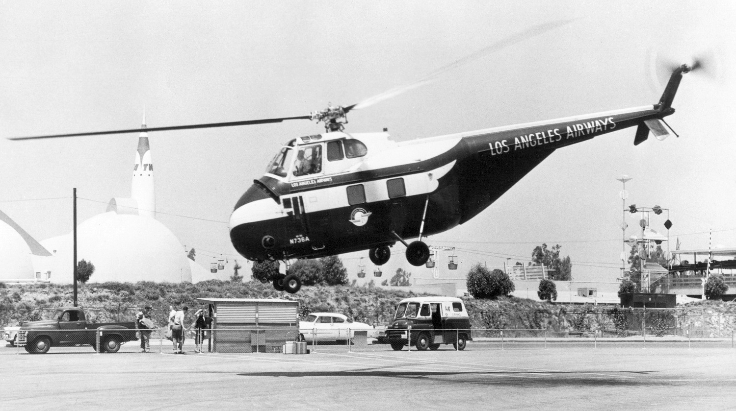
A 1956 photo of Los Angeles Airways Sikorsky S-55 N763A C/n 55773 departing from the Disneyland Heliport, with the TWA Rocket to the Moon in the background.
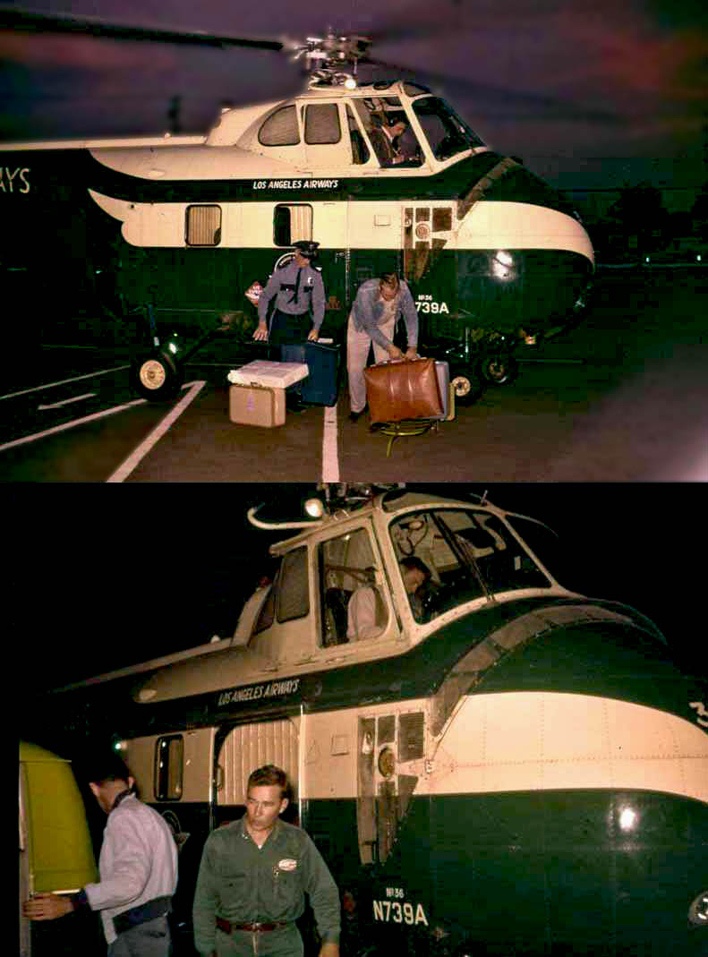
Two 1956 photos of a Sikorsky S-55 of Los Angeles Airways being loaded with passenger luggage at the Disneyland Heliport.
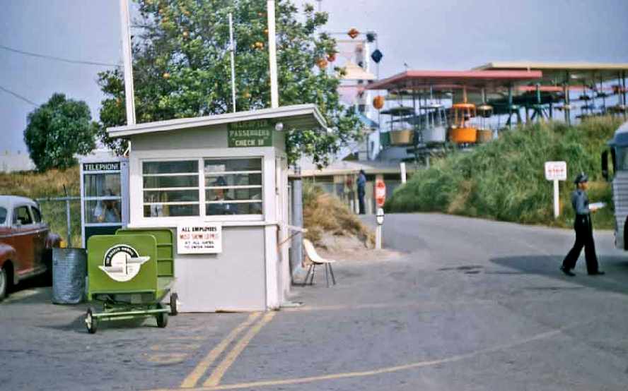
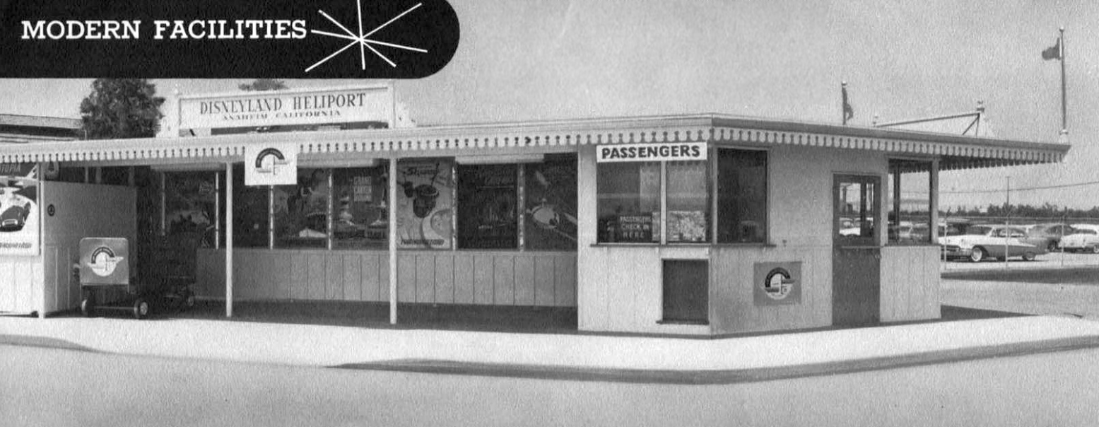
A 1956 photo of the “backstage” heliport entrance behind the Tomorrowland Skyway Station.
Note the sign reading “Helicopter Passenger Check In” on the shack,
and the luggage cart with the Los Angeles Airways logo.
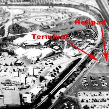
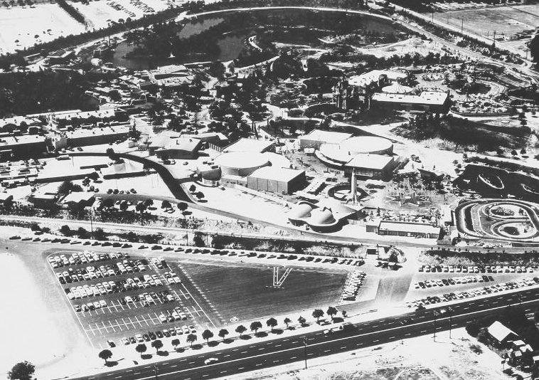
A 1956 aerial view looking north at Disneyland,
annotated by Scott O'Donnell to show the terminal shack & helipad of the 1st Disneyland Heliport.
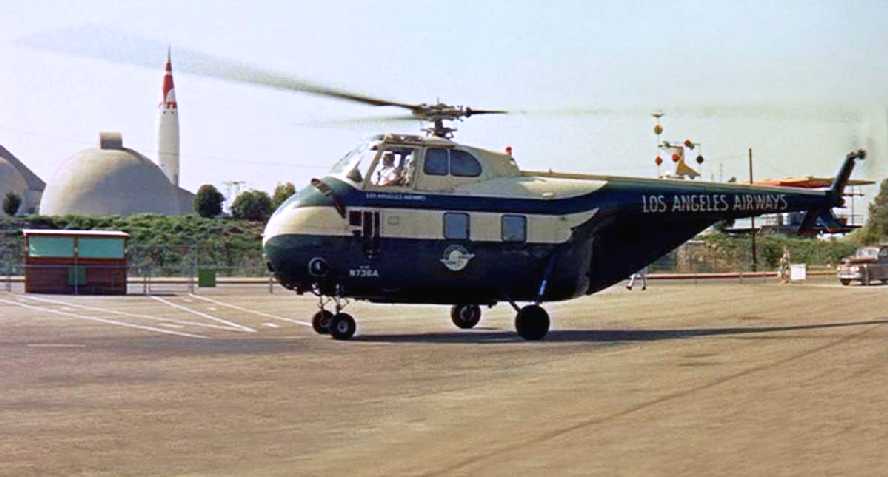
A circa 1950s photo of a Los Angeles Airways S-55 at the Disneyland Heliport.
A undated (circa 1950s?) photos of a Sikorsky S-55 of Los Angeles Airways at the Disneyland Heliport.
According to Scott O'Donnell, the 1st location of the Disneyland Heliport evidently lasted a mere 2 years,
as in approximately 1957 the Disneyland railroad tracks were re-aligned towards Harbor Boulevard, therefore displacing the original heliport.
It was replaced by a new heliport 140 yards to the south.
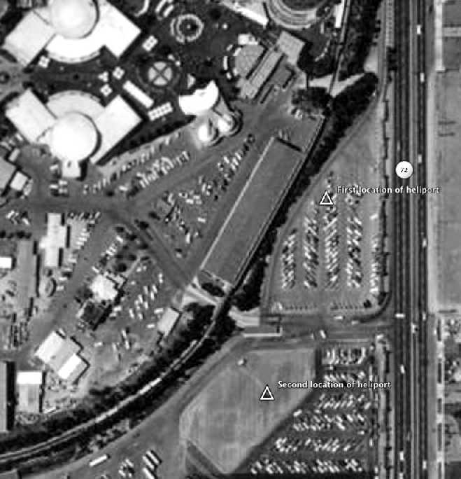
A June 1960 aerial view annotated by Scott O'Donnell to show the original locations of the Disneyland Heliport,
which by then had been displaced by the railroad tracks & covered with parking.
A 1963 aerial photo showed no trace remaining of the 1st location of the Disneyland Heliport, with car parking covering the site.
A 2006 aerial view showed the site of the original Disneyland Heliport having been covered with further development.
Thanks to Jeff Knapp for pointing out this airfield.
____________________________________________________
Disneyland Heliport (2nd location), Anaheim, CA
33.81, -117.916 (Northeast of Long Beach, CA)
A June 1960 aerial view annotated by Scott O'Donnell to show the 1st & 2nd locations of the Disneyland Heliport.
According to Scott O'Donnell, in approximately 1957 the Disneyland railroad tracks were re-aligned towards Harbor Boulevard,
therefore displacing the original location of the Disneyland Heliport.
The heliport was replaced by a new location just 140 yards to the south.
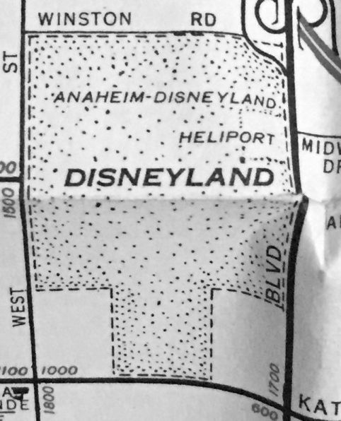
A 1960 street map depiction of the Disneyland Heliport (courtesy of Kevin Walsh).
According to Scott O'Donnell, the 2nd location of the Disneyland Heliport evidently only lasted 3 years,
as in 1960 it was replaced with yet another heliport, over 1,000 yards to the west, on the southwest side of the theme park.
A 1963 aerial photo showed no trace remaining of the 2nd location of the Disneyland Heliport, with car parking covering the site.
A 2/22/66 aerial view looking southeast at Disneyland's Tomorrowland,
showing the abandoned 2nd location of the Disneyland Heliport on the parking lot just beyond the monorail track.
A 2006 aerial view showed the site of the 2nd location of the Disneyland Heliport having been covered with the Disneyland Entry Esplanade & Tram complex.
____________________________________________________
Disneyland Heliport (3rd location), Anaheim, CA
33.811, -117.927 (Northeast of Long Beach, CA)
An undated photo from a circa 1961 brochure showing the Disneyland Heliport terminal building (courtesy of Don Ballard).
According to Scott O'Donnell, in 1960 the Disneyland Heliport was moved to its final location on the southwest side of the theme park.
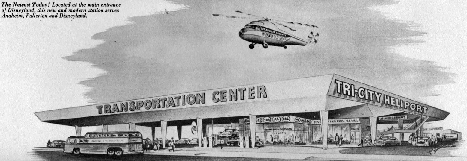
An artist's conception from a circa 1961 brochure showing a never-built Disneyland “Tri-City Heliport” (courtesy of Don Ballard).
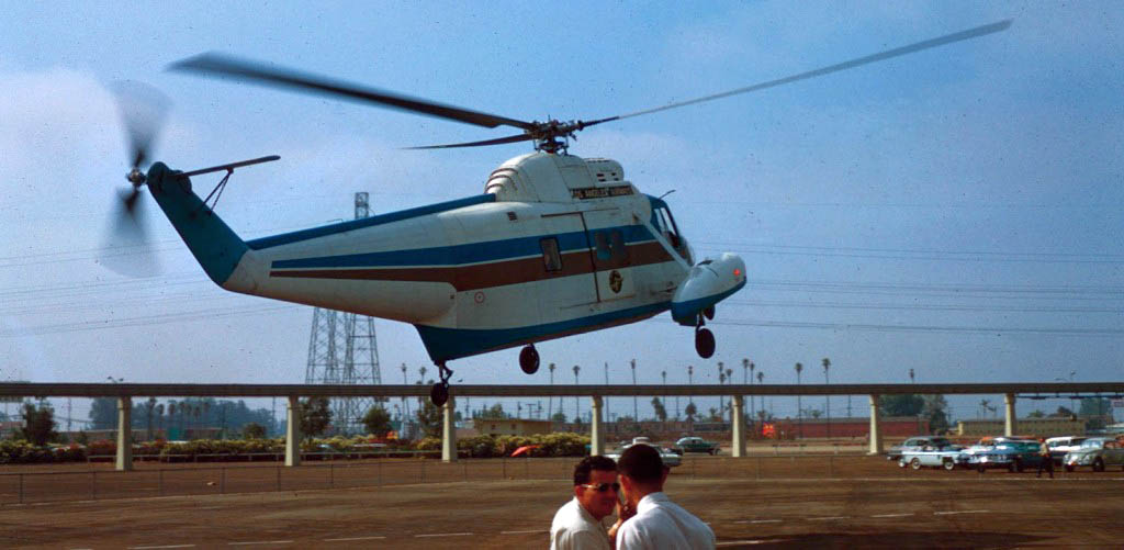
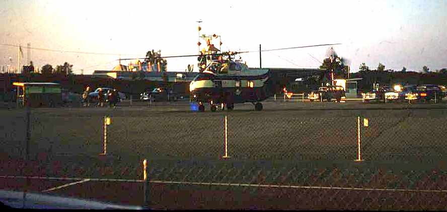
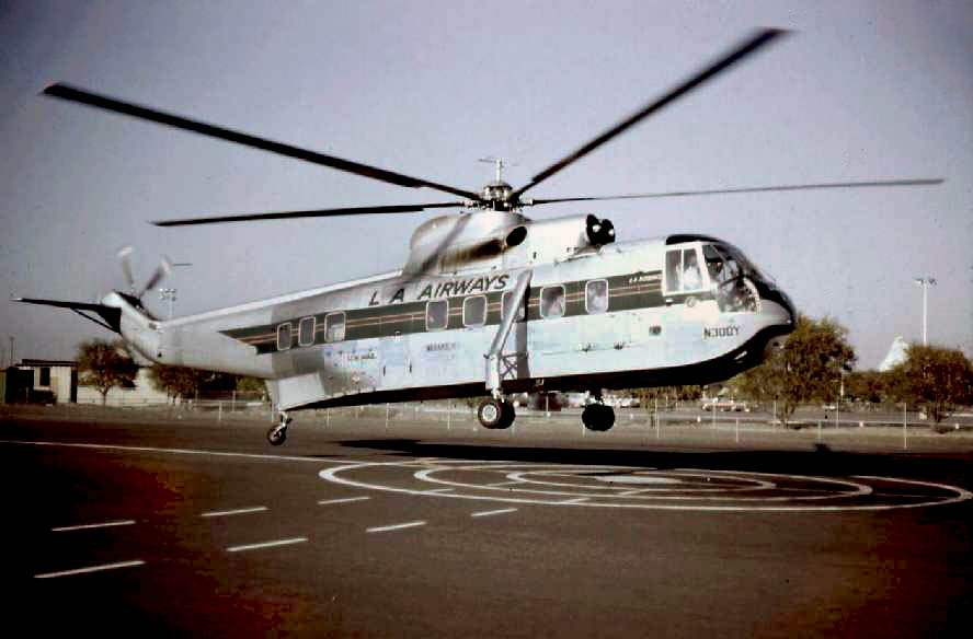
A 1961 photo of a Sikorsky S-62 departing from the Disneyland Heliport.
On 3/1/62, Los Angeles Airways became the 1st civil operator of the turbine-powered Sikorsky S-61L,
which had been purchased for $650,000 apiece.
These presumably replaced the much smaller S-55 helicopters on the Disneyland run.
The S-61L could seat up to 28 passengers, and cruised at 140 mph.
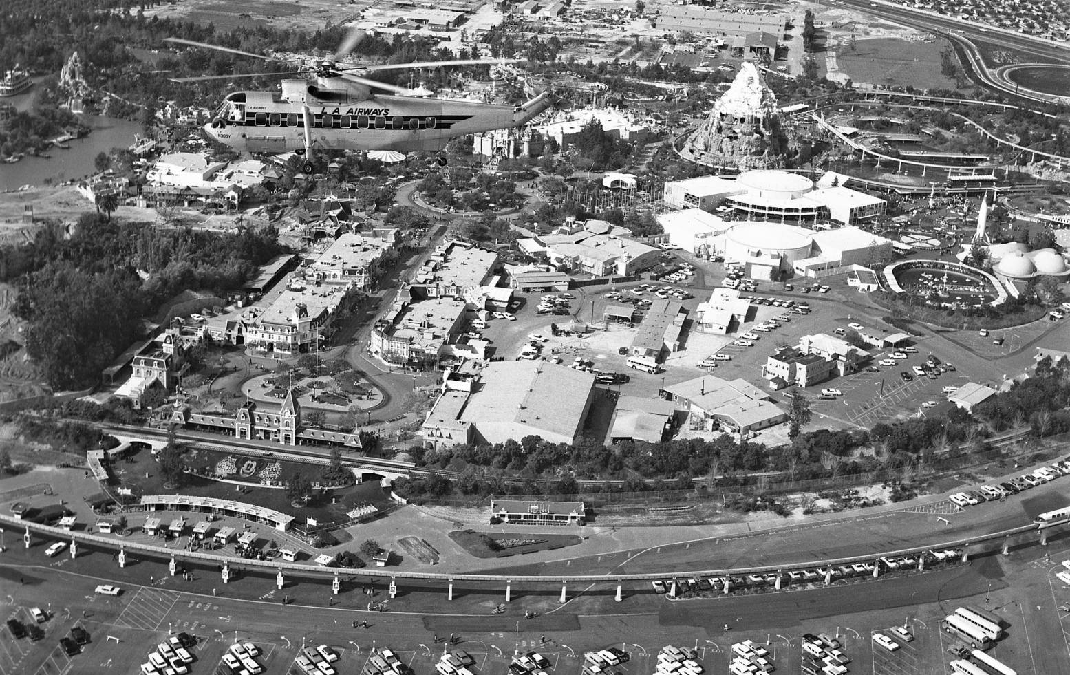
A circa 1962 aerial view looking northwest at a Los Angeles Airways Sikorsky S-61L overflying Disneyland (courtesy of Donald Ballard).
An August 1963 photo by Robert Boser of a Sikorsky S-61L of Los Angeles Airways taking off from the Disneyland Heliport
(this attribution link required with use of the photo outside of Wikipedia: EditorASC).
Note the Disneyland Matterhorn just visible in the background on the right. N300Y was the prototype Sikorsky S-61L.
Kelly recalled, “When I was in 2nd grade I had a girlfriend.
On her birthday her parents drove us to LAX, and we all flew to Disneyland on the LA Airways S-61 helicopter.
It was totally cool, we landed on the helipad at the old Disneyland Hotel.
We flew back to LAX that night & the city lights were amazing. I have never forgotten it.”
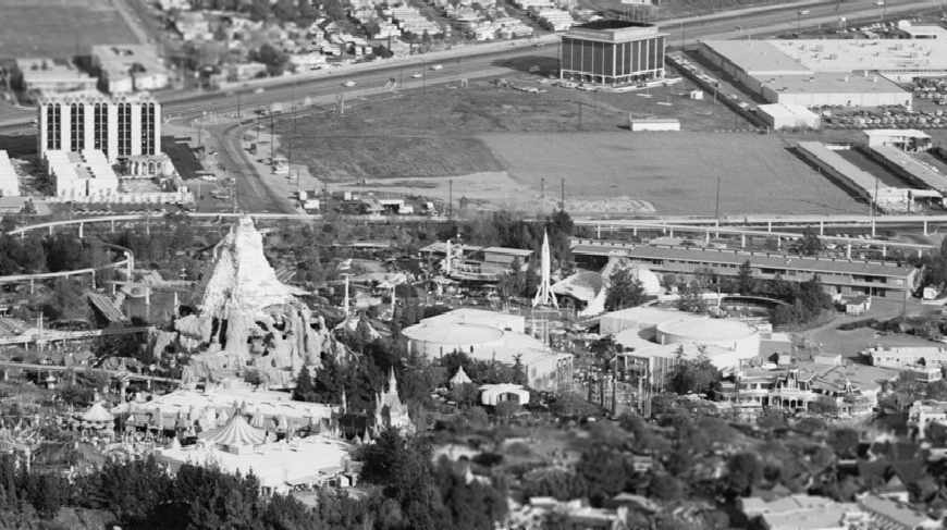
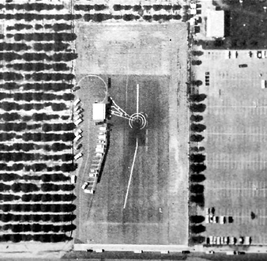
A 1963 aerial view looking northwest at the 3rd location of the Disneyland Heliport (courtesy of Don Ballard),
showing the small terminal building, a circular helicopter landing spot marking, a north/south approach line,
and the distinctive “V”-shaped painted marking leading to the terminal building, also seen on the previous Disneyland Heliports.
Note the orange groves adjacent to the west side of the heliport.
A circa 1964 aerial view showing the 3rd location of the Disneyland Heliport,
showing a circular helicopter landing spot marking, a north/south approach line,
and the distinctive “V”-shaped painted marking leading to the terminal building, also seen on the previous Disneyland Heliports.
Note the orange groves adjacent to the west side of the heliport.
Unfortunately, the Congressional subsidy for helicopter airlines expired in 1965,
it quickly became evident that helicopter airlines were not financially viable.
The Disneyland Heliport service suffered its 1st fatal accident on 5/22/68,
when S-16L N303Y was cruising at 2,000' near Paramount, after departing the Disneyland heliport, en-route to LAX.
At about 5:50 PM, Flight 841 suddenly broadcast a distress message: "L.A., we're crashing, help us!"
There were no survivors among the 20 passengers & 3 crew. The aircraft was destroyed by the impact & subsequent fire.
The crash was caused by a mechanical failure in the blade rotor system, which then allowed one blade to strike the side of the fuselage.
The other 4 blades were then thrown out of balance & all 5 rotor blades broke & then the rear fuselage & tail separated from the rest of the airframe.
Only 3 months later, on 8/14/68, Los Angeles Airways S-61L N300Y
was operating Flight 417 from Los Angeles International Airport to the Disneyland Heliport.
The aircraft & crew had completed 3 round trips to various destinations in the LA metro area beginning at 6:07 PDT
and departed the ramp at Los Angeles as Flight 417 at 10:26.
The VFR flight was cleared by Los Angeles Helicopter Control to take off & proceed eastbound at 10:28.
At 10:29 the flight reported to Hawthorne Tower that it was departing LA eastbound along Imperial Boulevard at 1,200'.
At 10:32 Helicopter Control advised, "LA 417, 7 miles east, radar service terminated."
The flight acknowledged, "417 thank you." This was the last known radio contact with the flight.
The aircraft crashed in a recreational park located in a residential area in Compton, with the loss of all 18 passengers & 3 crew.
Among the victims was passenger Christopher Belinn,
the 13-year-old grandson of Clarence Belinn, the founder & president of Los Angeles Airways.
The aircraft was destroyed by impact & fire.
The entire fuselage, both engines, main rotor head assembly, 4 main rotor blades, and the pylon assembly were located in the main impact area.
The 5th main rotor blade (yellow) including the sleeve & part of spindle,
was located approximately 0.25 miles northwest of the main wreckage site.
Minor parts associated with this rotor blade where scattered over a 3-block area northwest of the park.
Examination of the yellow blade spindle (S/N AJ19) revealed a fatigue fracture
in the shank of the spindle adjacent to the shoulder in the inboard end of the shank.
The probable cause of the accident was the fatigue failure of the yellow main rotor blade spindle
causing separation of the blade which made the aircraft uncontrollable.
The fatigue crack originated in an area of substandard hardness & inadequate shot peening.
Statements were obtained from 91 witnesses.
A consensus of their observations indicates that the helicopter was proceeding along a normal flightpath when a loud noise or unusual sound was heard.
A main rotor blade was either observed to separate or was seen separated in the vicinity of the main rotor disc.
As the helicopter fell in variously described gyrations, the tail cone either folded or separated.
Flight 417's Sikorsky S-61L, N300Y, was the prototype for the S-61L, and had accumulated 11,864 total flying hours prior to the day of the accident.
The S-61s were grounded until the problem was fixed.
The last aerial view which has been located of the 3rd location of the Disneyland Heliport was an 8/22/68 aerial view (from the USCB Library).
It appeared to show a helicopter parked on the heliport.
A circa 1960s/70s photo (courtesy of Kevin Walsh) of a Sikorsky S-61L with the Disneyland Hotel in the background.
Rick Shadforth recalled, “I worked for LAA as an avionics tech in 1970, during the last few months that LAA remained in business.
We had 2 S-61s that flew scheduled hops to Disneyland as well as Newport Beach.
I made several trips out to Disneyland to work on some ground support equipment.
We also assisted the Orange County Sheriffs office, providing airborne observations when a bunch of hippies took over Tom Sawyer's Island.
The only reason the flights to Disneyland were halted was because the company went out of business.”
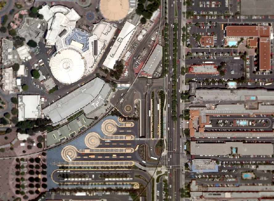
The Disneyland Heliport presumably closed at that point, having operated for a total of approximately 15 years in 3 different locations.
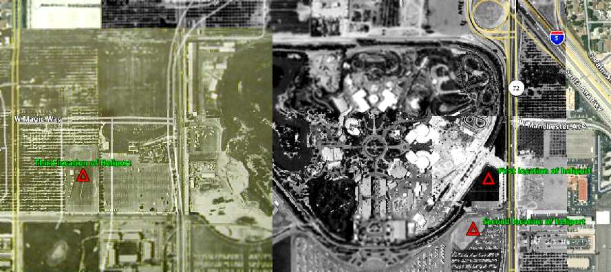
An aerial view annotated by Scott O'Donnell to show the sites of all 3 locations of the Disneyland Heliport.
A 1972 aerial view showed the former Disneyland Heliport terminal building remained, but the heliport was reused for car parking.
A 1997 aerial view showed the former Disneyland Heliport terminal building remained.
A 1998 aerial view showed the former Disneyland Heliport terminal building had been removed at some point between 1997-98.
An October 2007 aerial photo showed the site of the 3rd location of the Disney Heliport,
now unrecognizable as such, now having parking lots for the Disneyland Hotel.
____________________________________________________
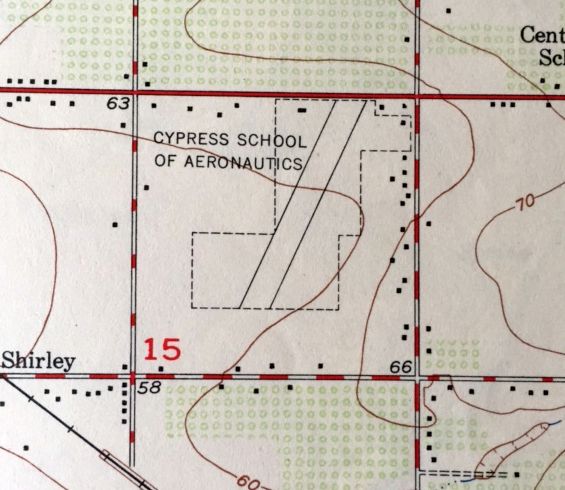
Cypress School of Aeronautics, Anaheim, CA
33.83, -118.02 (Northeast of Long Beach, CA)
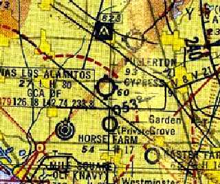
"Cypress" Airfield, as depicted on the 1947 LA Local Aeronautical Chart (courtesy of Tim Zukas).
Photo of the airport is not available.
Not much is known about this small flying school airfield, including its date of construction.
It was apparently built at some point between 1945-47,
as it was yet depicted on the August 1945 San Diego Sectional Chart (courtesy of Chris Kennedy).
The earliest depiction of the Cypress School of Aeronautics airfield which has been located
was on the 1947 LA Local Aeronautical Chart (courtesy of Tim Zukas).
It depicted Cypress Airfield as having a 2,200' unpaved runway.
Claudia Skapik recalled, “My father George Owens ran the Cypress School starting in about 1947.
My mother gave me my father's pilot logbooks & I found the notation of him leaving the Culver City Airport 4/13/47
and starting up his new operation at Cypress School of Aeronautics on 4/15/47.
In the beginning it was an airfield & a couple of buildings.
My dad George Owens & his partner Paul Blackman
(he owned a meat packing company & was the money of the partnership) started the business after the war.
Apparently the Government use to fund people who wanted to learn to fly [through the G.I. Bill].
My mother said that after the Government stopped paying people to learn to fly it was no longer profitable to run the school.
My father then closed the school & went to work for the then North American later Rockwell Aviation
and worked on the Apollo & then the Space Shuttle projects.”
Bruce Pasarow reported, “I have 2 advertisements (6/12/47 & 6/19/47) encouraging people to visit & take flying lessons at the Cypress Airpark.
Another item is an article & an advertisement in the 6/12/47 [Buena Park News] about the opening of the Cypress airfield.
Another item is an article (June 1947) about a secretary working for the Cypress airfield who took flying lessons in order to understand her job better.”
The 1949 USGS topo map (courtesy of Kevin Walsh) depicted the Cypress airfield
as consisting of a single 2,300' northeast/southwest runway within an irregularly-shaped outline.
The Cypress airfield was depicted on an early-1955 San Diego Sectional Chart (courtesy of Bob Cannon)
as having a 1,900' unpaved runway.
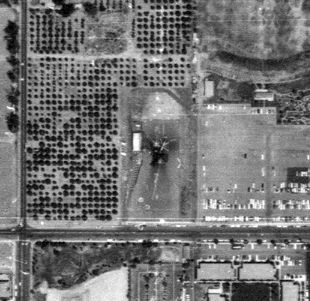
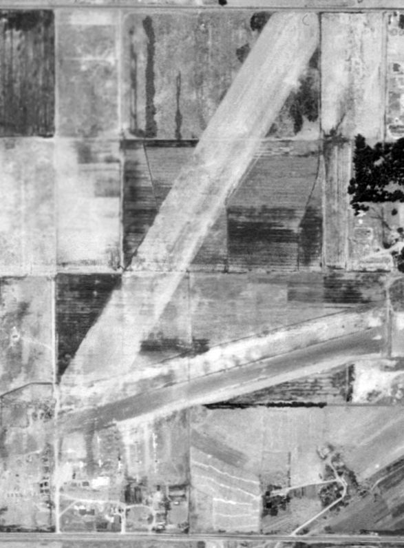
The earliest photo which has been located of the Cypress airfield was a 1953 aerial photo.
It depicted the field as having a single 2,300' northeast/southwest runway.
Rows of hangars were located on the northwest & northeast sides of the field,
and a dozen light aircraft were parked on the northwest side.
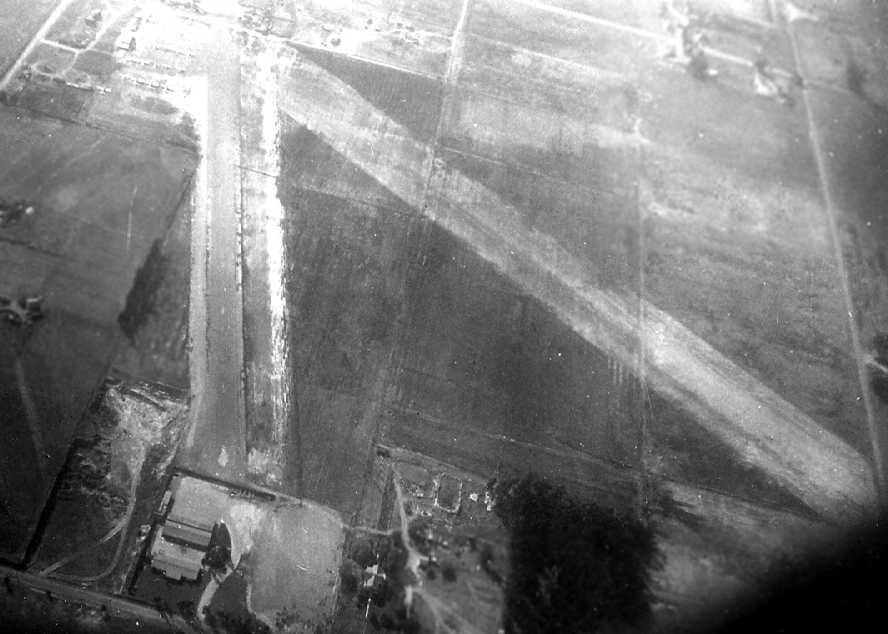
A 1954 aerial view depicted Cypress with the same layout, but the number of aircraft visible on the field had plummeted to only 3.
The Cypress School of Aeronautics airfield evidently closed (for reasons unknown) at some point during 1955,
as it was no longer depicted on the September 1955 San Diego Sectional Chart (courtesy of Chris Kennedy)
or subsequent aeronautical charts.
A 1972 aerial view showed that several drive-in movie theater screens covered the north side of the former airport property,
and a school covered the southern portion.
The 1998 USGS topo map indicated that the site of the former Cypress School of Aeronautics
had been reused as the site of Orangeview Junior High School & a hospital.
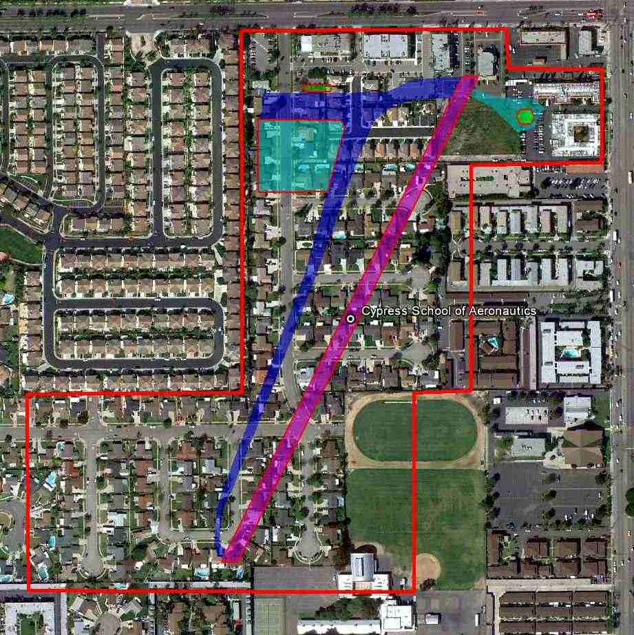
A 3/8/11 aerial photo annotated by Scott O'Donnell to show the layout of the Cypress School of Aeronautics Airfield. Not a trace of the airfield appeared to remain.
The site of the Cypress School of Aeronautics is located southwest of the intersection of South Knott Avenue & Lincoln Avenue.
Thanks to Francis Blake for pointing out this airfield.
____________________________________________________
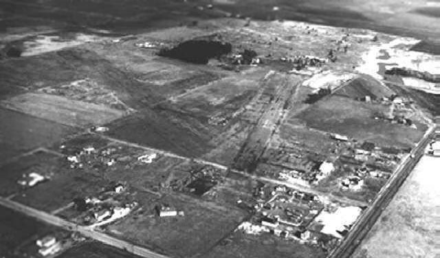
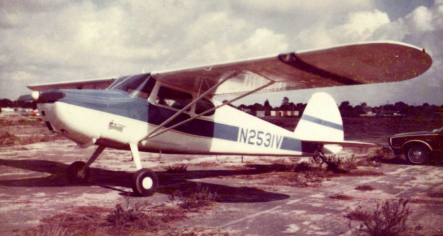
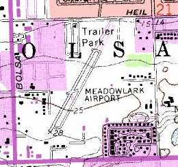
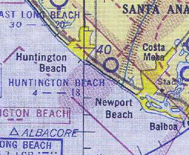
East Long Beach Airport / Sunset Beach Airport / Meadowlark Airport (L16),
Huntington Beach, CA
33.72, -118.037 (Southeast of Los Angeles, CA)
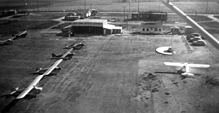
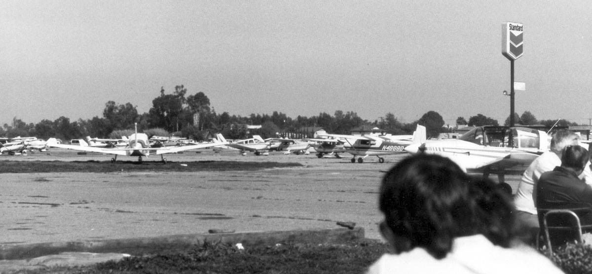
A 7/1/1947 aerial view of East Long Beach Airport (from the UCSB Library).
This very popular general aviation airfield
eventually had the unfortunate coincidence of being located on land which eventually became too valuable.
According to an article by Patrick Mott in the Los Angeles Times (courtesy of Bob Cannon),
"It's been the seat-of-the-pants flier's favorite hangout in Orange County since 1945,
a home for the gypsy in the private pilot's soul,
a gravelly oasis where you can cruise for burgers in your Cessna."
East Long Beach Airport was not yet depicted on the August 1945 San Diego Sectional Chart (courtesy of Chris Kennedy).
According to Rex Ricks, “East Long Beach Airport... was owned by Col. Willsie & partner.
They established the field in 1946.”
According to Steve Miller, “Col. Richard Willsie... owned the East Long Beach Airport until returning to active duty during the Korean War.”
The earliest depiction of East Long Beach Airport which has been located was a 7/1/47 aerial view (from the UCSB Library).
It depicted the field as having 2 unpaved runways in a “V” shape,
with a ramp with several small buildings & a group of light aircraft at the southwest end.
A 10/21/1947 aerial view by Harry Gordon looking west at East Long Beach Airport
depicted the field as having 2 unpaved runways in a “V” shape,
with a ramp with several small buildings & a group of light aircraft at the southwest end.
A 10/21/1947 aerial view by Harry Gordon of the hangar (marked with “East Long Beach Airport”), office building,
fuel pump, and several tailgragger single-engine planes.
The 1947 LA Local Aeronautical Chart (courtesy of Tim Zukas)
depicted “Sunset Beach” Airport as having a 1,900' unpaved runway.
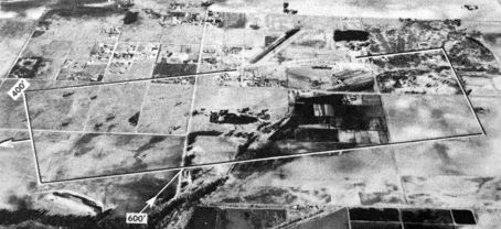
An undated aerial view looking north at East Long Beach Airport from the 1950 Air Photo Guide (courtesy of Kevin Walsh).
The guide described East Long Beach Airport as having two 2,000' oiled paving runways, oriented east/west & northeast/southwest.
It listed the managers as Richard Willsie & Charles Hopton.
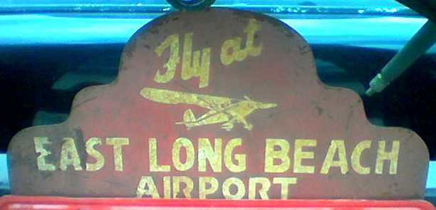
A photo by Rex Ricks of a automobile license plate frame advertising East Long Beach Airport.
The 1950 Sectional Chart (according to K.O. Eckland) described East Long Beach as having three 2,400' dirt runways.
According to Rex Ricks, “Col. Wiltsey sold out when he was recalled for Korea.”
According to the Nerio Family, “The Koichi & Toyo Nerio family bought Meadowlark Airport in 1952.”
A 12/26/52 aerial view of Meadowlark Airport (from the UCSB Library).
An early (undated) aerial view looking northeast at East Long Beach Airport.
"East Long Beach" Airport, as depicted on the September 1955 San Diego USAF Sectional Chart (courtesy of Chris Kennedy).
The Aerodromes table described the field as having 2 "oil mix" runways, the longest being 2,050'.
The airfield was next renamed Sunset Beach Airport.
Bob Cannon recalled, "My first landing at Sunset was 9/3/55 in my 7AC.
First time to try the beach air enhanced hamburgers. Got hooked from then on!
I have a 1956 LA Local [Aeronautical Chart]. L16 is [listed as] Sunset Beach."
Eric Coleson recalled, “In September of 1959, my dad dropped me & my bicycle off at Sunset Beach Airport,
gave Abe Paster $8 for my first flying lesson in a 7AC Champ, wished me a happy 12th birthday, and told me to be home before dark. Wah hoo!
It was nearly a year of weekends loading clay pigeons in the trap house at my gun club before I'd amassed enough money to begin flight training in earnest.
Abe Paster was still there in 1960, but Harry Ross had the FBO at mid-field with a ramp full of Cessnas equipped with gyros!
Harry, a former mayor of Seal Beach who'd spent much of WW2 ferrying multi-motor transports into the Pacific theater from Long Beach, had taken over the airport lease.
The new Cessna 150s rented for $9.50/hour wet, but they were an obvious step nearer the DC-7s & Connies I had aspired to fly in the future.
My second flying lesson was in a straight-tail Cessna 150 with CFI Ed Rice, who'd flown F-4U Corsairs with the USMC in the Korean conflict.
By the end of September in 1960, I was washing & refueling airplanes, making coffee, emptying ash trays & sweeping out the patio as a line boy along with Ed Rice's son Dale,
in exchange for flying time; an hour of dual in the 150 for each day of labor.”
Eric continued, “By Christmas that year, Ed had me flying mostly under the hood & in Harry's Cessna 172.
The secretary for whom I'd worked at the gun club, a diminutive lady of stern demeanor (the result, I thought, of years suffering fools with firearms)
had expressed interest in my progress as a flying student, and I invited her to join me & my instructor for a flight in the 172.
I was about to introduce her to Harry Ross when I saw by his stunned expression & her grin, that they had already met.
Unknown to me before that moment, Ms. Beatrice Medes was a former WASP, Class of 43W3.
In late 1943 & early 1944, she'd been the Operations Officer of the WASP group at Long Beach, single; a 'real looker'; and the object of a determined pursuit at which Harry had failed repeatedly.”
Eric continued, “The real estate business for single family homes was really booming across Heil Avenue, on the airport's north boundary.
Harry began getting noise complaints in alarming numbers.
There was a lady over there somewhere, who'd phone noise complaints in to the police even when we were completely fogged in & not flying.
We finally realized that she was phoning in complaints about 'those noisy little airplanes' whenever a Navy S-2F 'Stoof' from Los Alamitos or something being vectored in to Long Beach flew by above the undercast!”
Eric continued, “One of those clear, beautiful Saturday mornings when everybody was flying in to shoot a few landings, Harry asked me to join him in a house-buying adventure.
The developer had a model home on display right on the north side of Heil & exactly on the extended centerline of our Runway 19.
During a tour of the house Harry pointed out to the salesman that while no airport appeared on the map in his sales brochure, there sure were a lot of little airplanes flying low over the house.
The salesman explained they'd left the airport off the map because they'd already formed a homeowners' group that would have 'that little nuisance across the street' shut down forthwith.
Harry replied that he'd be unable to buy a house if they succeeded, because he managed that little nuisance across the street. In fact, his business there was his sole source of income.”
Eric continued, “Harry did buy that very house. It turned out to be not only a great investment, but also a useful approach aid.
A year later, Ed Rice would fly Harry's Aero Commander 500C over to Long Beach, load up the seats with hunters or fishermen & fly them to Bishop,
from where a bush pilot with a Cessna 180 would take them up into the eastern Sierras.
He'd then fly the empty Aero Commander down to Lone Pine & load up about 600 pounds of freshly baked sheepherder's bread at Dan Schaat's bakery for sale in Safeway markets.
Arriving back at Sunset Beach in the pre-dawn morning, Ed could drag the twin in at about 300 feet over that housing tract & line up with the runway
by putting Harry's back porch light in line with the big illuminated sign at the Shell Station on the corner of Warner & Bolsa Chica.
When Harry's porch light disappeared under the nose, it was time to get the last notch of flaps, pitch down to maintain Vxse, and voila!
There's the threshold for Runway 19, illuminated right there by the landing lights.”
Eric continued, “The runway was more than long enough to handle the Aero Commander.
Young Gary Morehouse (a future Continental Airlines captain) built up a lot of multi-motor hours on it in the family Piper Apache.
Ten years later & after the runway had been paved, I flew a Cessna 310Q in for breakfast several times... two-up; before the day warmed up; and with a little on-shore breeze always welcome.
Balanced field length for the 310 worked out to something like 30 feet shy of the quonset hut. Admittedly, that runway looked real short & narrow from 500 feet & a mile at 93 knots.”
Eric continued, “Jack Strother, a retired navy CPO, opened an instrument school in the Quonset hut toward the end of 1960,
installing 4 of the Link ANT-18 'Blue Box' trainers he'd run as chief of the flight simulator training shop at NAS Los Alamitos.
I kept the place swept out & the coffee pot fresh there during February & March of 1961, in exchange for about thirty hours of Link time.
A section of the hut's north wall had been cut away to form a comfortable patio. Jack's wife would bring sandwiches for lunch, and we'd all sit out on the patio & watch airplanes.”
Eric continued, “I think it was sometime in late 1961 or early 1962 that Harry Ross was lost somewhere between Utah & home.
Harry's widow, Elaine, took over the FBO & re-married to Hamilton 'Ham' Ward, a high school teacher from Garden Grove who'd recently licensed as a CFI.
By September of 1963, they'd relocated the FBO from mid-field to Abe Paster's old digs across the entry road from the Quonset hut.
Ed Rice was still instructing, but ailing, and it was Ham Ward who soloed me there on my 16th birthday.
The runway had been paved by then, and the name changed to Meadowlark.
Stuff happens; things sometime come full circle; and I didn't get another flight out of Meadowlark until March of 1969,
when I took my wife for her first airplane ride there in a 7AC Champ rented from... Abe Paster.”
Sunset Beach Airport was described in the 1962 AOPA Airport Directory
as having a single 1,900' road mix Runway 1/19, and the operator was listed as Abe Paster.
Rick Truofreh recalled, “My next flight was at the age of 6 [1962], from Meadowlark Airport in a Piper Tri-Pacer.
The pilot let me take the controls for a minute.... Wow!
I remember seeing the 'toy houses' & cows, horses, trees & cars from the window of the plane, looking down.”
"Sunset Beach" Airport, as depicted on the March 1963 LA Sectional Chart (courtesy of Bob Cannon).
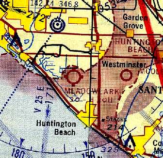
The airport had been renamed "Meadowlark"
by the time of the August 1963 San Diego Sectional Chart (courtesy of Bob Cannon).
By 1964, the field had been paved, as the August 1964 LA Local Aeronautical Chart (courtesy of Donald Felton)
described Meadowlark as having a 1,900' hard-surface runway.
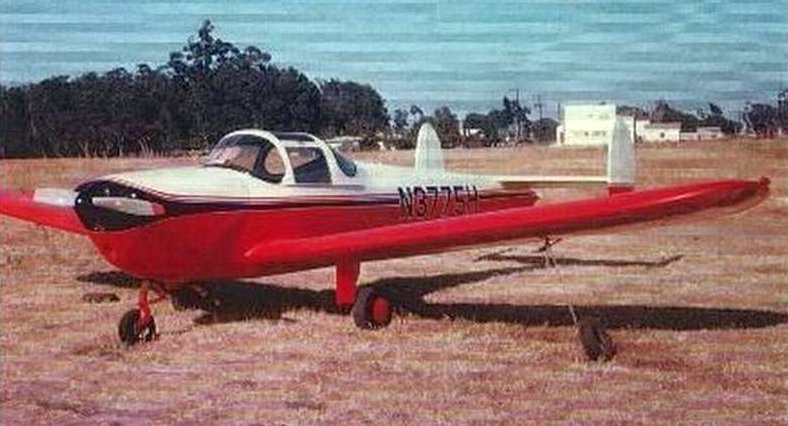
A circa 1960s photo of an ERCO 415D Ercoupe at Meadowlark Airport.
The earliest topo map depiction which has been located of Meadowlark Airport was on the 1965 USGS topo map,
which depicted the field as having a single paved northeast/southwest runway with a parallel taxiway.
The August 1965 San Diego Sectional Chart (courtesy of Ron Kunse)
depicted Meadowlark as having 2 paved runways, with the longest being only 1,900'.
Eugene Friedrich recalled, “I used to be an owner of the flight school & Link Trainer at Meadowlark.”
A 7/2/67 aerial view of Meadowlark Airport (from the UCSB Library).
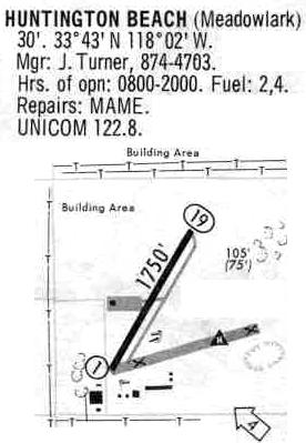
Meadowlark was depicted in a 1968 airport directory (courtesy of Glenn Beltz) as having a single 1,700' paved Runway 1/19,
which was renowned among California pilots for being an extremely short runway.
According to the Nerio Family, “In 1969, when the previous airport managers had issues with the leasing agreement,
eldest son Art took over & actively began managing the airport operation for 20 years until its closure in 1989.
Art enjoyed the camaraderie of the pilots & the airport gang while he managed the fixed base operators & tie-downs,
collected landing fees on his bicycle, pumped av fuel, and maintained just about everything else.
Art’s sister Betty was the cheerful smiling face assisting in the operation of the airport.
She kept the office running, maintained the books, pumped gas & assisted the customers.
And brothers Yukio & Art worked on developing the airport property.”
Harry Corrigan recalled, “Meadowlark.. I used to fly out of there about 1970.
It was in an Aeronca 2-seater, with my dad always in the back seat. I think the Aeroncas rented for $4/hour.
I never was licensed, but my dad says I often did the whole flight myself, with him never touching the controls, so I consider myself a light plane pilot.
My father was Douglas Corrigan, 'Wrong Was to Ireland, 1938'.”
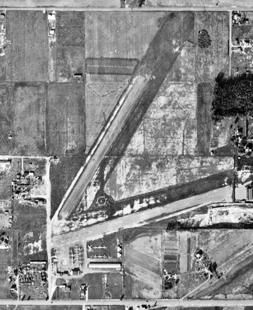
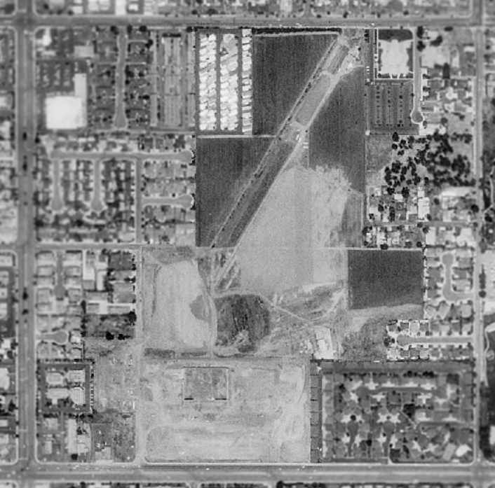
A 12/9/74 USGS aerial view depicted Meadowlark Airport as having a single paved northeast/southwest runway, along with a former crosswind runway.
Over 70 light aircraft were visible on the field.
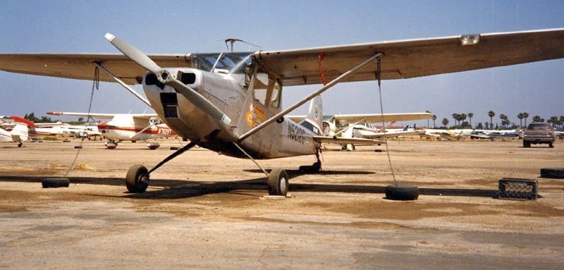
A circa 1970s photo of a Cessna O-1 Bird Dog at Meadowlark Airport.
The 8/14/75 LA Helicopter Aeronautical Chart depicted Meadowlark as having 2 paved runways.
A 1975 photo of a Cessna 170 at Meadowlark.
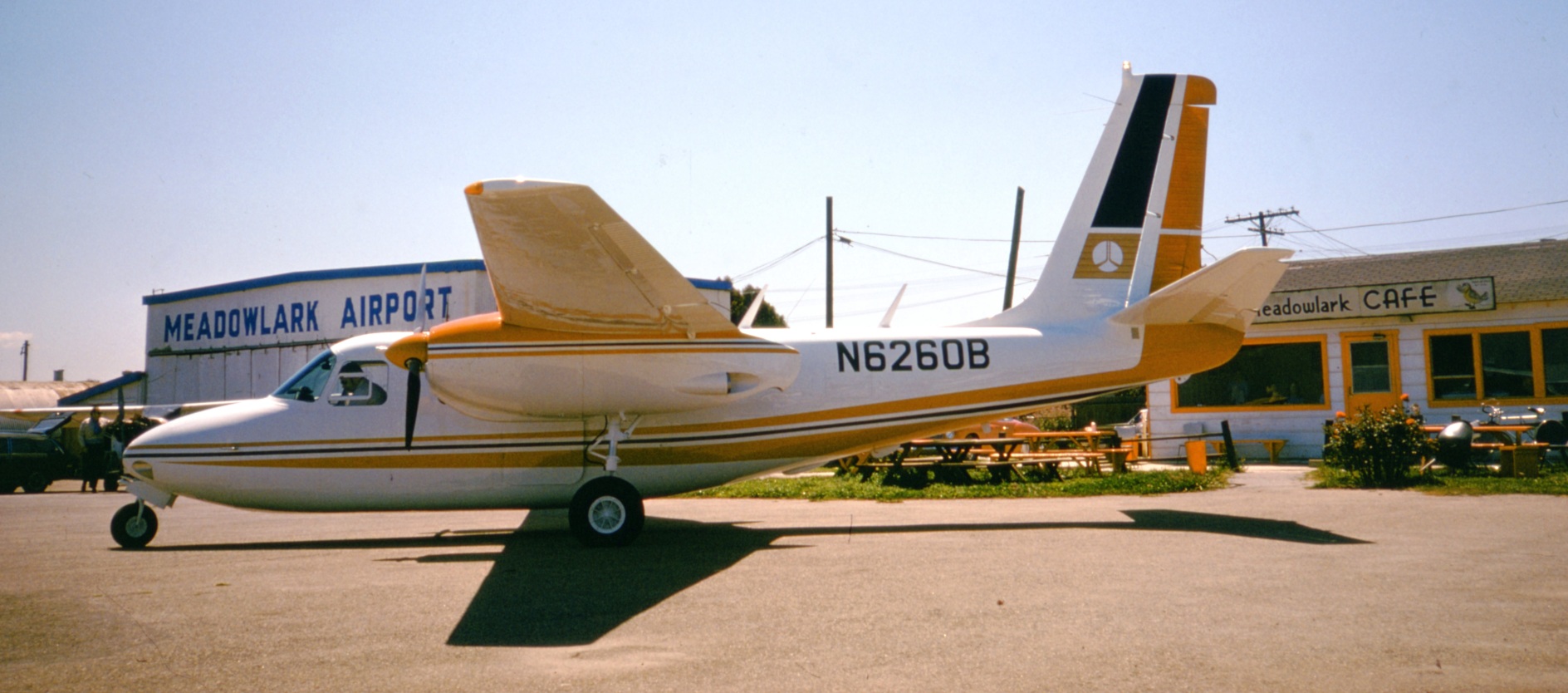
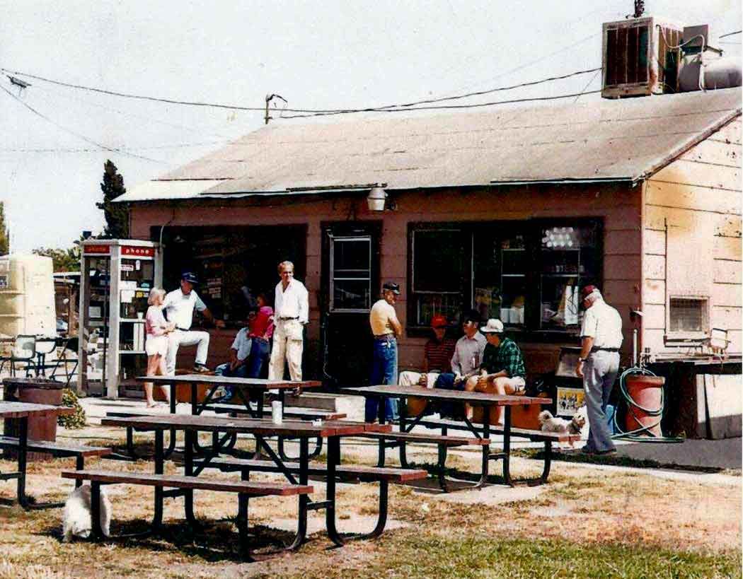
A May 1975 photo by Nick Williams of Rockwell Twin Commander N6260B c/n 500-670-23 in front of the Meadowlark Cafe.
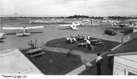
A 1977 photo of the Meadowlark ramp.
Aerial view of Meadowlark, © 1978 by Chris Bell, used by permission.
Rex Ricks observed, “Our house on end of Old Pirate Lane is at lower left edge.
Our Bellanca Cruisair, next to our house, is not aligned with taxiway.”
A 1978 aerial view looking northeast at Meadowlark by Bob Cannon,
showing how close the houses were surrounding the field by that point.
An undated photo by Linda Liem (courtesy of Pat Nerio) of the airport crowd hanging out at Meadowlark Airport.
Rex Ricks recalled, “I grew up right next to the field & one of my favorite childhood pastimes
was launching golf balls with a baseball bat in the section where the former east runway had been;
it was a big patch of weeds in the 1970s.
So there was no possibility of hitting any windows.
Today a kid in Orange County would be very hard pressed to find a similar amount of open space that I enjoyed at Meadowlark.”
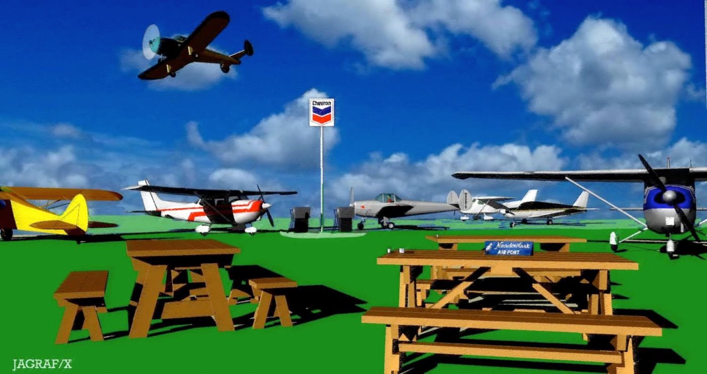
A computer rendering by Ron Jagodinski of “a Sunday at Meadowlark – an Ercoupe makes the mandatory 15 degree right turn after takeoff.”
Ron Jagodinski recalled, “I lived near Meadowlark Airport in the 1970s.
Landings cost about $5 if anyone was present at the Meadowlark Cafe to take your money.
Folks from Brackett Field & virtually all over would drop down to stretch their legs & have breakfast at the Meadowlark Cafe.
The largest aircraft we ever saw land there was a Beech 18 with 2 people in it. The old cafe was a great place for airplane discussions.
One sunny Saturday morning an entire squadron of Globe Swifts dropped in out of nowhere for breakfast.
Finished with breakfast & showing off their restorative work on the Swifts, they all took off in-line with a tremendous roar accompanied by low airspeed - if noise was power.
From the downwind leg, Meadowlark looked about as big as the USS Langley.
Ex F-100 driver Tom Reed out of Chino took one look out the window of his 310 on downwind & passed on any landing attempt.”
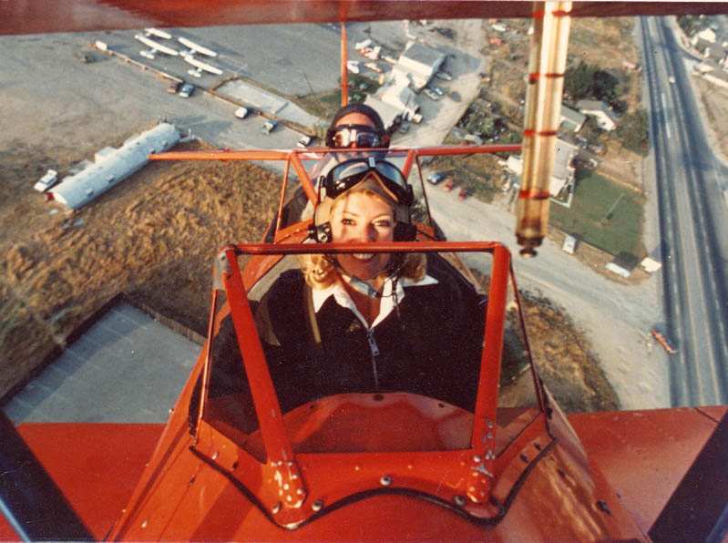
A beautiful picture (circa 1978-79) by Bob Cannon, of his PT-17 pulling up over Meadowlark Airport,
showing "the Meadowlark driveway, flight school & covered pool, restaurant,
and the ever-present Quonset Hut that got plugged so many times by wayward aircraft."
A circa 1978-79 picture by Bob Cannon of his PT-17 flying inverted off the coast near Meadowlark Airport.
Bob recalled, “I got in the good graces of a camera representative for Nikon who set up the remote cameras for me.
It was sort of special back then.
We also made a movie with air shots by mounting a camera on the fuselage in the small inspection hatch near the tail.
Those were great. He also took a very nice picture of my 2 Stearmans flying formation
over the windsock when my wedding was being held."
Unfortunately, a late 1970s accident involving another banner tow pilot near Capistrano Airport
precipitated negative feelings toward Meadowlark Airport.
Bob Cannon recalled, "That accident precipitated the beginning of all of my problems with the city of Huntington Beach.
The city council was staffed mainly by developers, and they wanted the airport for development."
Aerial view of the ramp at Meadowlark, date unknown.
The last aeronautical chart depiction which has been located of Meadowlark was on the July 1980 LA Terminal Chart (courtesy of Jim Hackman),
which depicted Meadowlark as having a single 2,300 paved runway.
USGS topo map 1981 (courtesy of Dann Shively).
In the 1982 AOPA Airport Directory (courtesy of Ed Drury),
the operators at Huntington Beach were listed as Williams Aviation Company, Art World,
Coastal Aviation, Sky Ad, and Aircraft Services.
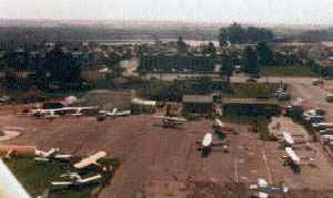
A 1982 photo of a very popular Meadowlark Airport ramp.
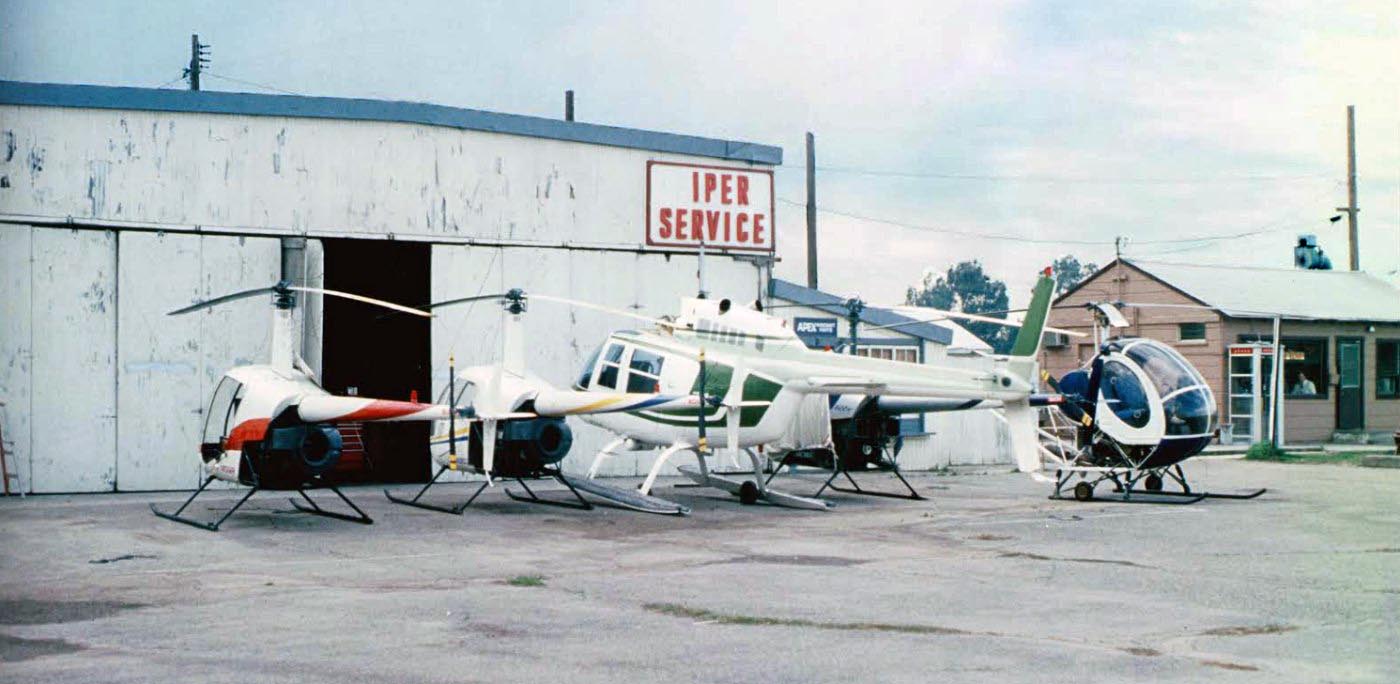
A circa 1983 picture by Mark Robinson of several Robinson, Bell, and Hughes helicopters at Meadowlark Airport
in front of a hangar of “a facility of my friend Andy Thompson from Steam Maintenance.”
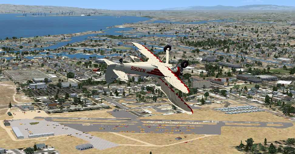
A Flight Simulator scenery re-recreation by Richard Finley of a Waco UPF-7 performing aerobatics over Meadowlark.
Alan Horowitch recalled, “Meadowlark was a little gem of an airfield
that I flew to several times in the early 1980s when I first got my license.
Small, fun, friendly, and surrounded by conniving Southern California real estate developers.
So everyone knew back then that it was on borrowed time.”
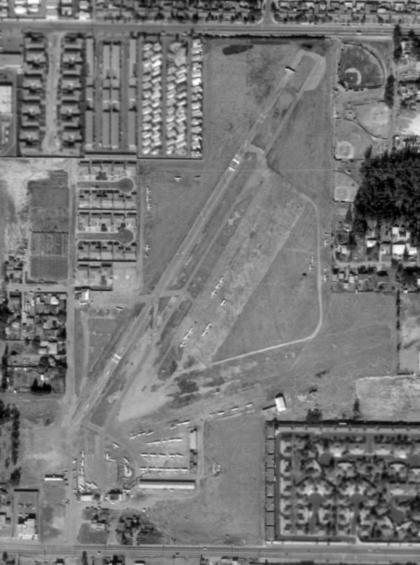
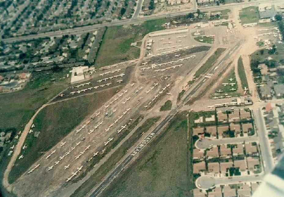
Meadowlark had a large paved ramp area, which accommodated 300 based light aircraft by 1986.
The Meadowlark Café was a popular pilot eatery.
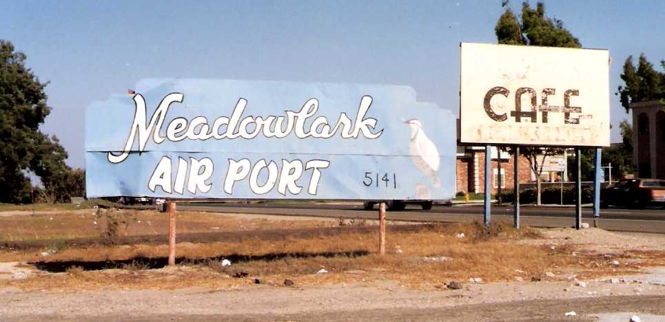
A late 1980s photo by Chris Bell of signs for Meadowlark Airport & its cafe.
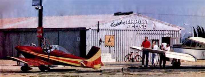
A photo of 2 planes in front of the Meadowlark office,
from the 8/4/89 issue of the Los Angeles Times (courtesy of Bob Cannon).
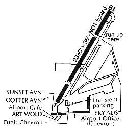
The 1989 Pilot's Guide to CA Airports (courtesy of Scott Saylor)
depicted Meadowlark as having a single 2,330' paved Runway 1/19,
with a parallel taxiway & large paved ramp on the east side, and a small paved ramp on the west side.
Hangars were located along the south side of the field.
The operators were listed as Sunset Aviation, Art Wold, Cotter Aviation, and Sky-Ads.
A computer rendering by Ron Jagodinski of a “friend of mine bringing his 172 in for one of the last Meadowlark landings over Heil Avenue.”
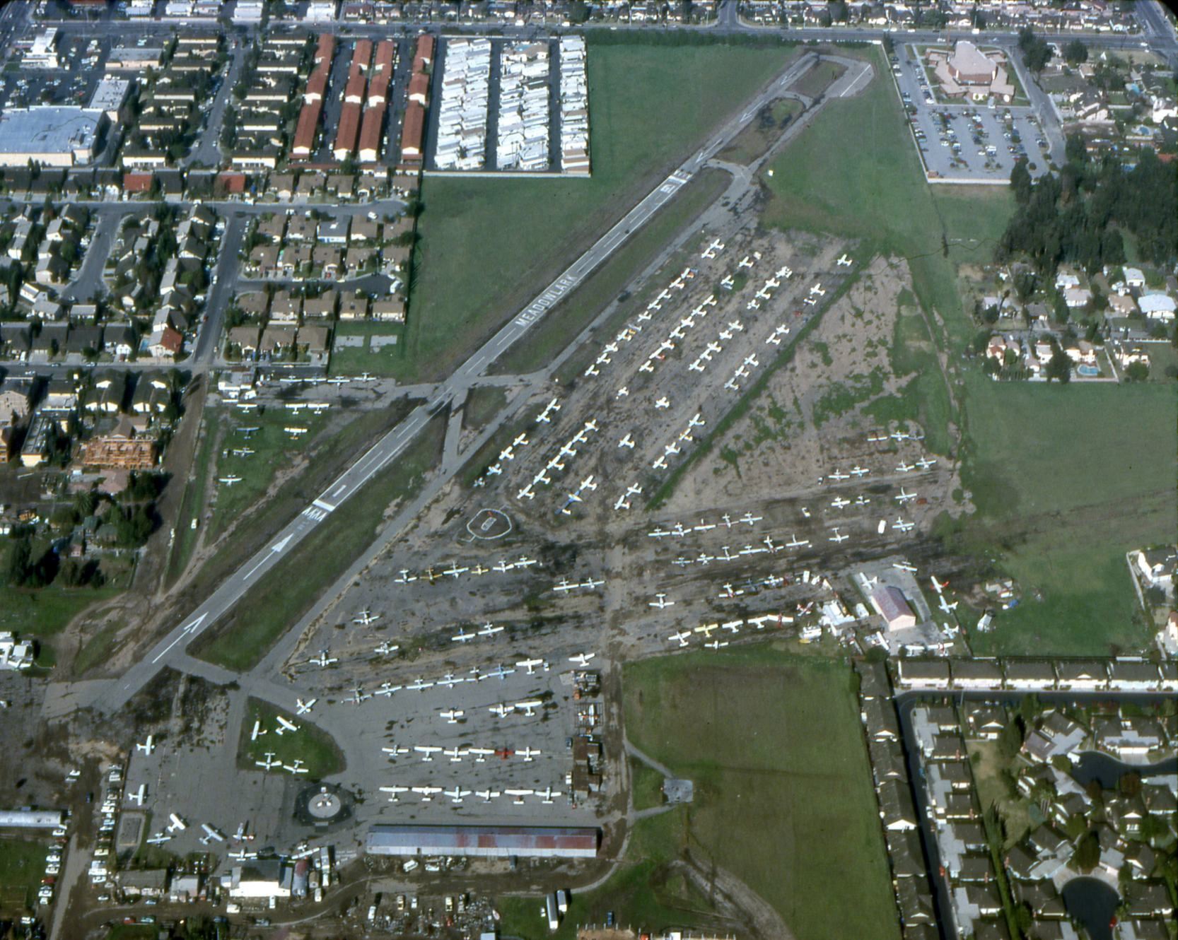
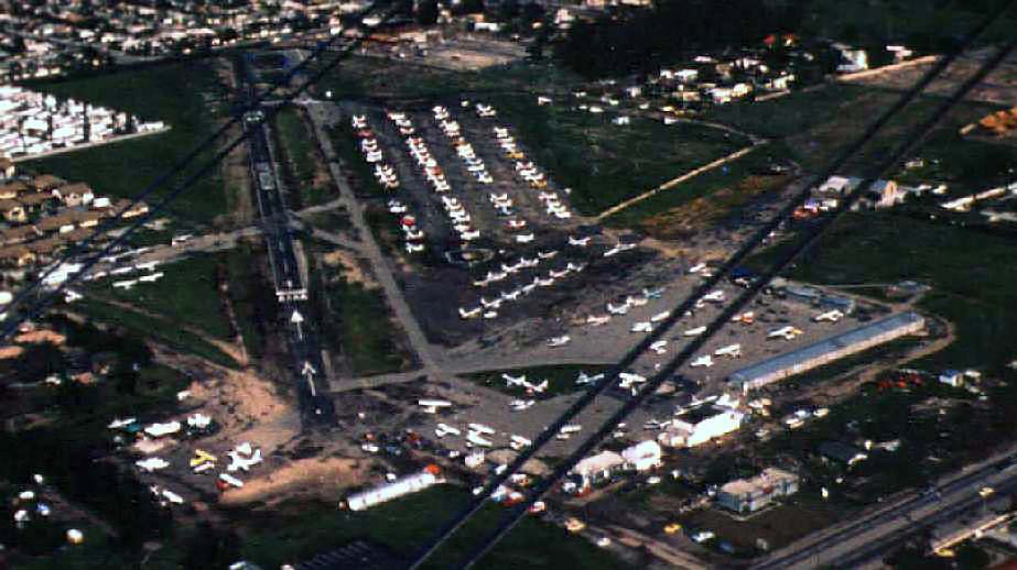
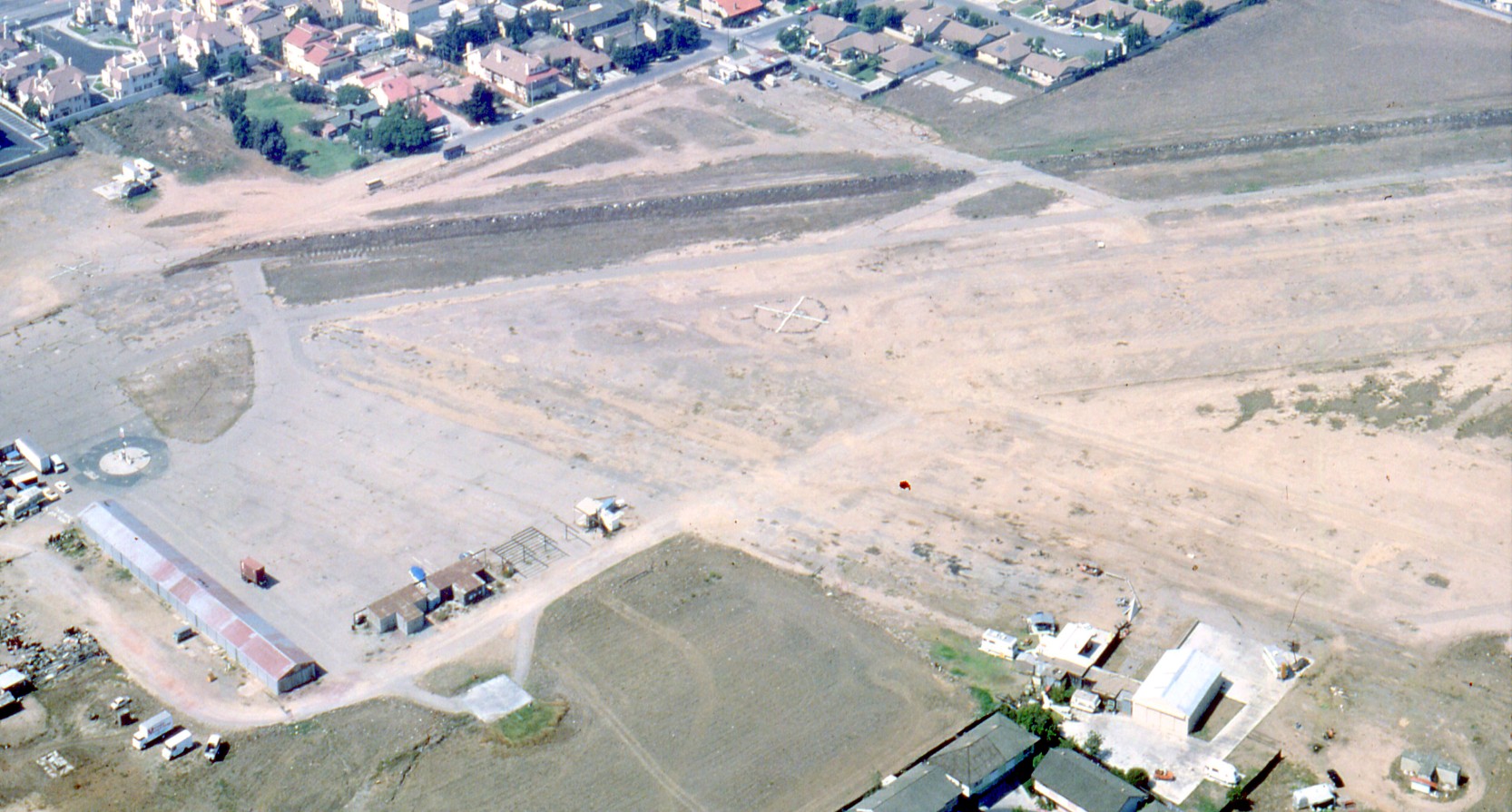
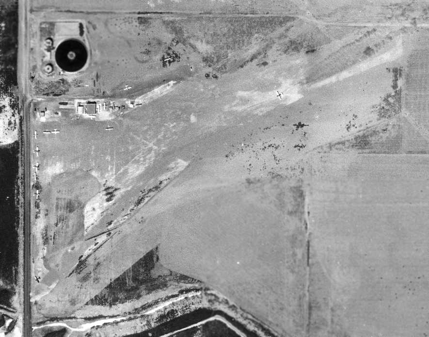
A 1989 aerial view by Dave Stevens looking north at Meadowlark Airport in its last year of operation, showing a very popular little airport, with dozens of light general aviation aircraft.
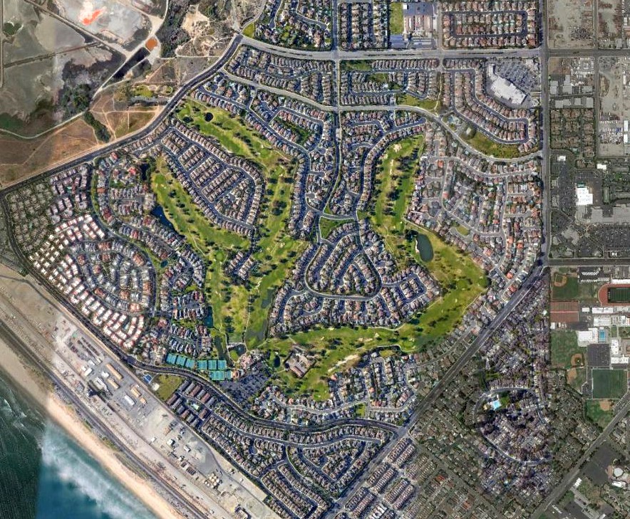
According to Linda Liem (who along with Chris Austin owned Sunset Aviation), Meadowlark closed in 1989.
Construction to redevelop the airport property started later the same year.
According to the Nerio Family, “After years of neighbors' complaints & rising commercial opportunities, the Nerio family finally closed the airport in September of 1989.
Meadowlark Airport was developed into a shopping center & residential community.”
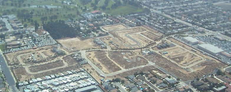
A sad early 1990s aerial view by Dave Stevens looking northwest at the site of Meadowlark Airport, showing the airport buildings being removed.
In the 1994 USGS aerial view, portions of the northern half of Meadowlark's former runway & its parallel taxiway still remained intact,
although the majority of the airport property had been cleared for redevelopment.
Denny Sun pointed out in 2006, “The north/south street just to the west of the shopping center is named Airport Circle.
I don't think many people today know what Airport Cir is referring to.”
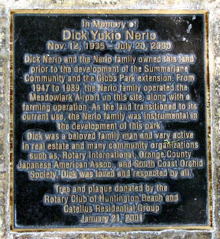
A June 2009 photo by Alan Ray of a plaque commemorating Dick Nerio, one of the owners of Meadowlark Airport,
in Gibbs Park, within the Summerlane development of the airport site.
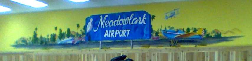
A 2009-2010 photo (courtesy of Rex Ricks of a mural inside a nearby Trader Joe's grocery store commemorating Meadowlark Airport.
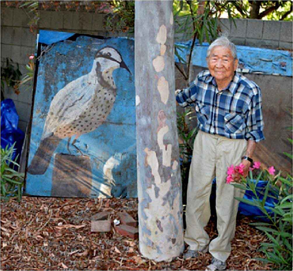
An 8/9/14 photo by Pat Nerio of former Meadowlark Airport owner Art Nerio next to the Meadowlark sign.
Pat reported, “Since the airport closed in 1989, this original Meadowlark Airport sign has been resting in Art Nerio's backyard!”
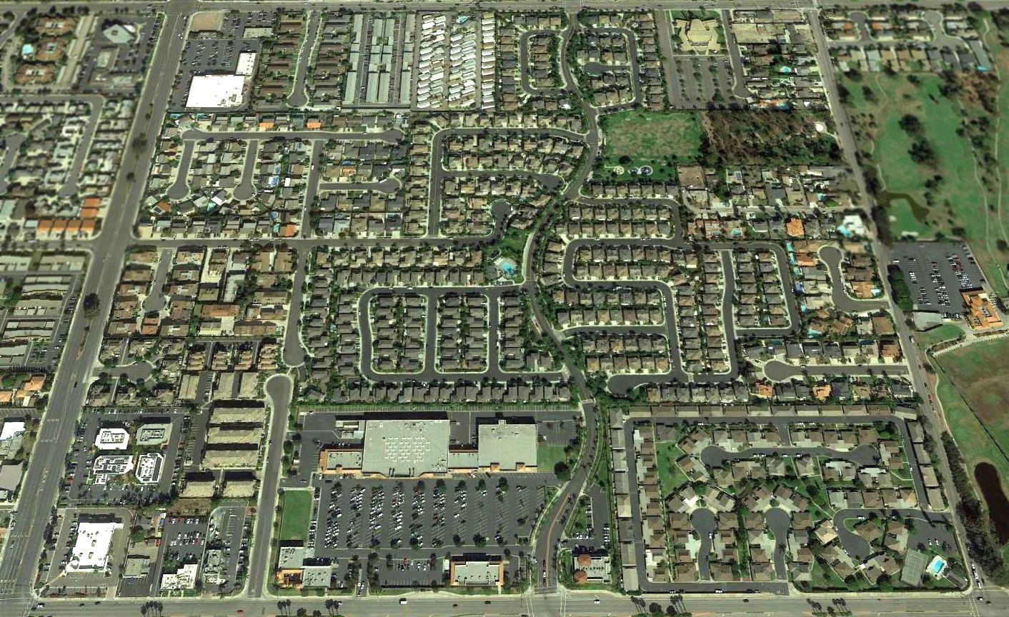
A 2016 aerial view looking north shows that no trace remains of Meadowlark Airport.
Thanks to Scott Saylor for pointing out this airfield.
Details of Meadowlark Airport are lovingly recounted at www.l16.com,
http://bannerbob.net/Meadowlark.htm, and http://bannerbob.net/newsprints.htm.
____________________________________________________
Huntington Beach Airport (1st location), Huntington Beach, CA
33.681, -118.014 (Southeast of Los Angeles, CA)
An undated aerial view looing east at the Huntington Beach Airport from the 1932 U.S. Navy Aeronautical Chart (courtesy of Roger Connor).
The date of construction of Huntington Beach Airport has not been determined.
The earliest depiction which has been located of Huntington Beach Airport
was an undated aerial photo from the 1932 U.S. Navy Aeronautical Chart (courtesy of Roger Connor),
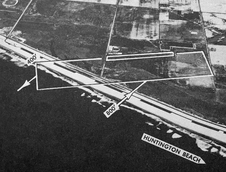
which depicted it as having a single east/west runway ending directly across the road from the beach.
The only aeronautical chart depiction which has been located of the 1st location of Huntington Beach Airport
was on the 1932 U.S. Navy Aeronautical Chart (courtesy of Roger Connor),
which depicted Huntington Beach as an auxiliary airfield on the northwest side of the town.
The original Huntington Beach Airport was evidently closed (for reasons unkown) at some point between 1932-34,
as it was no longer depicted on the February 1934 San Diego Sectional Aeronautical Chart (or subsequent charts).
Although the precise site of the 1st location of Huntington Beach Airport has not been determined,
a 2018 aerial view shows the general location occupied by the SeaCliff Country Club, bearing no recognizable trace of a former airport.
____________________________________________________
Huntington Beach Airport (2nd location), Huntington Beach, CA
33.646, -117.979 (Southeast of Los Angeles, CA)
The 2nd location of Huntington Beach Airport, as depicted on the February 1947 San Diego Sectional Chart.
The 2nd location of Huntington Beach Airport was located on the southeast side of the town.
It was apparently established at some point between 1946-47,
as Huntington Beach Airport was not yet depicted on the August 1946 San Diego Sectional Aeronautical Chart.
The earliest depiction which has been located of the 2nd location of Huntington Beach Airport was on the February 1947 San Diego Sectional Chart.
An 8/23/47 aerial photo of the Huntington Beach Airport (courtesy of Robert Pope)
depicted the field as having a single northeast/southwest unpaved runway.
The airport was in use with well over a dozen aircraft present,
including an airplane seen halfway down the runway on takeoff, with cloud of sand/dust being blown in the plane's wake.
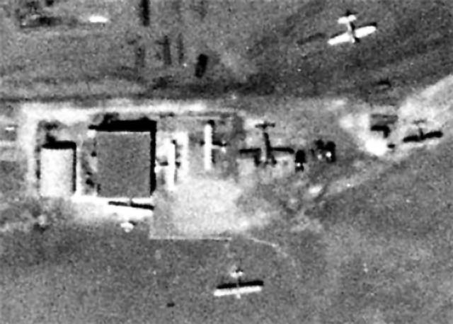
A closeup from the 8/23/47 aerial photo of Huntington Beach Airport (courtesy of Robert Pope)
showing several aircraft parked around a few small buildings.
The concrete pad & foundations for a future hangar were already in place.
The 1947 USGS topo map labeled the field as “Huntington Beach”.
The 1948 San Diego Sectional Chart (according to Chris Kennedy)
described Huntington Beach Airport as having a 1,900' unpaved runway.
The last photo which has been located showing Huntington Beach Airport while still in operation
was an undated aerial view looking north from the 1950 Air Photo Guide (courtesy of Kevin Walsh).
The guide described Huntington Beach Airport as having an 1,800' dirt northeast/southwest runway, and listed the manager as John Garrish.
The 1951 USGS topo map (courtesy of Kevin Walsh)
depicted Huntington Beach Airport as having a single northeast/southwest runway.
Huntington Beach Airport was apparently closed at some point between 1950-55.
It was still depicted on the September 1955 San Diego Sectional Chart (courtesy of Chris Kennedy)
and described as having a single 1,850' bare runway, but the remarks said "Closed".
An 11/26/55 aerial view (courtesy of Robert Pope) showed that Huntington Beach Airport's hangar had been completed,
but the airport was no longer operating, and the land was being redeveloped for other use.
Huntington Beach Airport was still depicted on the March 1956 San Diego Sectional Chart.
By the time of the October 1956 San Diego Sectional Aeronautical Chart, Huntington Beach Airport was no longer depicted at all.
An 8/11/61 aerial view (courtesy of Robert Pope) showed the site of the former Huntington Beach Airport
after construction of a new stormwater channel & Edison electric power generation station on the former airport property.
The airport hangar was relocated approximately 500' to the north & rotated 90 degrees, to the north side of Edison Street.
The distinctive geometry of the buildings, identical size, and even identical locations of the skylights
all confirmed that this was the relocated former hangar.
A 1972 aerial photo showed that the site of the former airport had been covered with fuel tanks for the Edison powerplant.
The Huntington Beach Channel also had been cut through the center of the former airfield area.
The hangar was the only trace of the former airport which appeared to remain.
A circa 2006 aerial view looking south at the 60-year old hangar which was relocated to the north side of Edison Avenue,
across the street from the site of Huntington Beach Airport.
As seen in a 4/16/13 aerial photo, the site of Huntington Beach Airport was no longer recognizable as former airport.
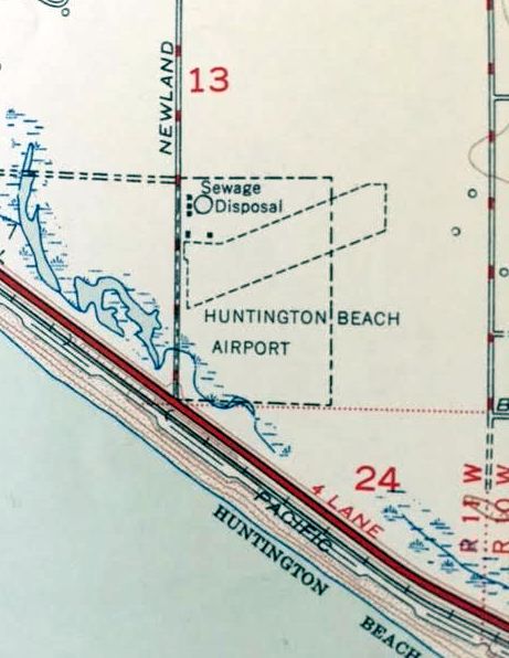
The site of Huntington Beach Airport is located east of the intersection of Newland Street & Edison Avenue.
Thanks to Francis Blake for pointing out this airfield.
____________________________________________________
Naval Outlying Landing Field 08303 / Horse Farm Naval Outlying Landing Field /
Horse Farm Airport, Stanton, CA
33.794, -118.006 (East of Los Alamitos AAF, CA)
A 7/21/43 aerial view looking north at “Los Alamitos Field Auxiliary (08303 Horse Ranch Outlying Field)”
from the 1945 AAF Airfield Directory (courtesy of Scott Murdock).
The date of construction of this WW2-era Navy satellite airfield is unknown.
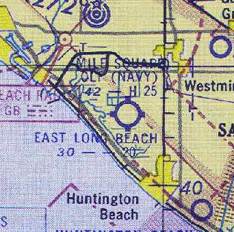
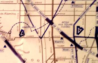
Horse Farm was originally one of 5 NOLFs which were closely located between Los Alamitos & El Toro:
the others were Haster Farm NOLF, Mile Square NOLF, Seal Beach NOLF, and Palisades NOLF.
Mile Square was built in 1942, so Horse Farm was probably built around the same time.
The earliest depiction which has been located of the Horse Farm Airfield
was a 7/21/43 aerial view looking north at “Los Alamitos Field Auxiliary (08303 Horse Ranch Outlying Field)”
from the 1945 AAF Airfield Directory (courtesy of Scott Murdock).
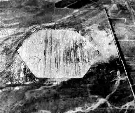
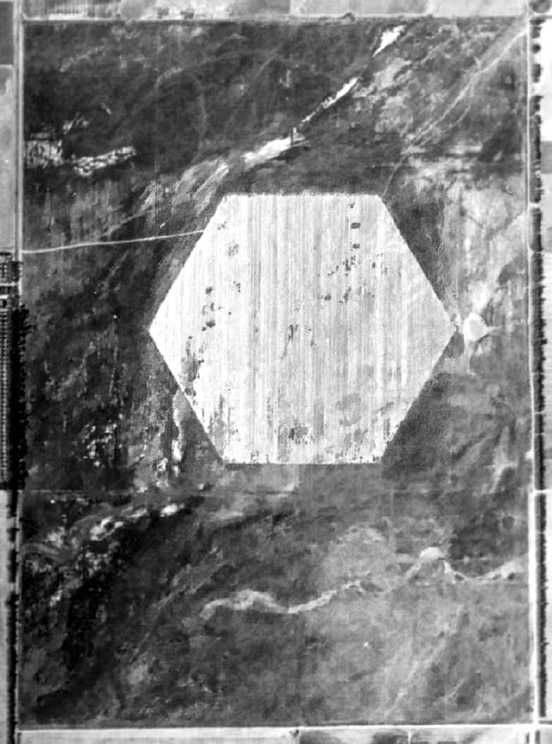
It depicted the field as a paved hexagonal landing mat.
A circa 1943 chart of NAS Los Alamitos & several of its outlying fields (courtesy of John Voss),
including NOLF Horse Farm (08303).
Note that the chart also depicted NOLF 13207 (Mile Square), NOLF Haster Farm (11005),
NOLF Seal Beach (21104), as well as 2 “proposed” fields which were never built.
The earliest depiction which has been located of NOLF Horse Farm was on the March 1944 San Diego Sectional Chart.
It depicted "(Navy) Horse Farm" as an auxiliary airfield.
The 1945 AAF Airfield Directory (courtesy of Scott Murdock) described “Los Alamitos Field Auxiliary (08303 Horse Ranch Outlying Field)”
as a 288 acre irregularly-shaped field within which was a 1,500' diameter bituminous hexagonal landing mat
in the center of a 3,966' x 2,911' all-way landing area.
The field was said to not have any hangars.
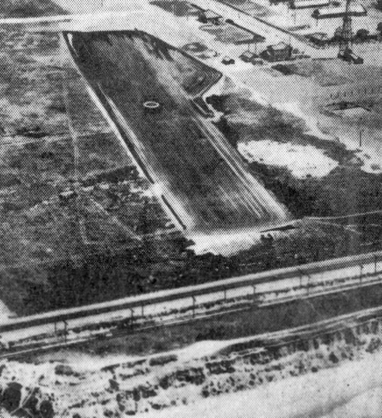
An 8/14/45 U.S. Government aerial photo (National Archives photo, courtesy of Brian Rehwinkel)
depicted Horse Farm OLF as consisting of a hexagonal landing area, measuring 1,400' across.
The Navy apparently abandoned the Horse Farm airfield immediately after the end of WW2,
as it was no longer depicted at all on the February 1946 San Diego Sectional Chart (according to Chris Kennedy).
However, the Horse Farm airfield was apparently reactivated
in some capacity by the Navy at some point between 1946-47,
as "Horse Farm (Navy)” was depicted once again on the 1947 LA Local Aeronautical Chart (courtesy of Tim Zukas).
It was depicted as having a 1,700' paved runway.

The September 1948 San Diego Sectional Chart (courtesy of Chris Kennedy)
depicted "Horse Farm (Navy)” as having a 1,700' hard surface runway.
As depicted on the 1950 USGS topo map (courtesy of Scott O'Donnell),
the airfield at Horse Farm consisted of a hexagonal landing area, measuring 1,400' across.
It was still apparently owned by the military in 1950,
but it is not known if it was still an active airfield.
"Horse Farm (Navy)" was depicted on the March 1951 San Diego USAF Sectional Chart(according to Chris Kennedy),
but the Aerodromes table described the field as "Closed".
A 1953 aerial view depicted the hexagonal landing area, but without any sign of current usage.
At some point between 1951-55, Horse Farm was apparently reused as a private airfield,
as that is how it was described in the "Aerodromes" table on an early-1955 San Diego Sectional Aeronautical Chart (courtesy of John Voss).
The airfield was described as consisting of a single 1,700' runway, along with the remarks "Very poor runway."
The Horse Farm airfield evidently closed (for reasons unknown) at some point during 1955,
as it was no longer depicted on the September 1955 San Diego Sectional Chart (courtesy of Chris Kennedy) or subsequent aeronautical charts.
In 1956, the property at Horse Farm was reused as the location for the Nike Ajax surface-to-air missile battery LA-32, Garden Grove,
and the airfield was presumably closed.
The Nike Integrated Fire Control Site was built at the northwest corner of the site (southeast of Patterson & Knott),
and the Launch Site was built at the southeast corner of the site (northwest of Chapman & Western).
Battery LA-32 was upgraded to the more powerful Nike Hercules missile in 1963.
The Horse Farm property in 1964, from the Anaheim Library (courtesy of Scott O'Donnell).
The Nike Fire Control Site is visible at the northwest corner,
and the Nike Launch Site is at the southeast corner.
The light colored triangular patch running between the 2 Nike sites was not a former runway,
but presumably was a swath which was cleared to provide a clear field of view for the Nike radars - ?
There was no trace remaining of the former hexagonal landing pad.
A 1972 aerial view showed that the site of the Horse Farm airfield was still open farmland,
with the Nike installations at the northwest & southeast ends.
The Horse Farm Nike missile battery was deactivated in 1974.
The 485th MASH of the CA Army National Guard later reused part of the Horse Farm property, at 11751 Western Avenue.
According to Marc Henegar, “This was also where one of the SoCal TRACON terminal radar antennas was located.
It was not on LGB or SNA as one might assume, it was in the middle of an industrial area -
and the old location of the Horse Farm Naval OLF probably explains why it was located there.”
The site of the Horse Farm airfield eventually was consumed by urban sprawl.
The outline of the Horse Farm airfield, as annotated by Chris Kennedy over a 2006 aerial photo of the site.
Not a trace remains of the former airfield.
However, note the same trapezoidal shape around the buildings at the northwest corner,
which is identical to the way it appeared in the 1964 photo.
The site of the Horse Farm airfield is bounded by Chapman Avenue on the south, Patterson Drive on the north,
Knott Avenue on the west, and Western Avenue on the east.
____________________________________________________
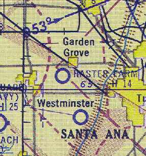
Naval Outlying Landing Field 11005 / Haster Farm Naval Outlying Landing Field /
Haster Farm Airport, Westminster, CA
33.763, -117.965 (Southeast of Los Alamitos AAF, CA)
A 7/21/43 U.S. Government aerial photo looking north at Haster Farm OLF (National Archives photo, courtesy of Brian Rehwinkel).
The date of construction of this WW2-era Navy satellite airfield is unknown.
Haster Farm was originally one of 5 NOLFs which were closely located between Los Alamitos & El Toro:
the others were Horse Farm NOLF, Mile Square NOLF, Seal Beach NOLF, and Palisades NOLF.
Mile Square was built in 1942, so Haster Farm was probably built around the same time.
NOLF Haster Farm was not yet depicted on the October 1942 San Diego Sectional Chart.
The earliest depiction of the Haster Farm airfield which has been located
was on a 7/21/43 U.S. Government aerial photo (National Archives photo, courtesy of Brian Rehwinkel).
It depicted the field as consisting of a hexagonal landing area.
A circa 1943 chart of NAS Los Alamitos & several of its outlying fields (courtesy of John Voss), including NOLF Haster Farm (11005).
Note that the chart also depicted NOLF 13207 (Mile Square), NOLF Horse Farm (08303),
NOLF Seal Beach (21104), as well as 2 “proposed” fields which were never built.
The earliest depiction which has been located of NOLF Haster Farm was on the March 1944 San Diego Sectional Chart.
It depicted "(Navy) Haster Farm" as an auxiliary airfield.
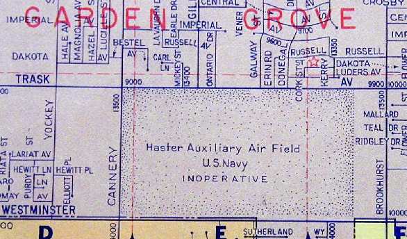
The 1945 AAF Airfield Directory (courtesy of Scott Murdock) described “Los Alamitos Field Auxiliary (11005 Haster Farm Outlying Field)”
as a 241 acre rectangular property within which was a 1,500' diameter asphalt hexagonal landing mat in the center of a 3,983' x 2,645' all-way landing area.
The field was said to not have any hangars.
Judy Whilson recalled, “In about 1945 my father bought a 10-acre farm at 9141 Trask Avenue, facing Haster Field.
Mr. Haster lived across the street & a little to the south.
My brother & I spent lots of hours on our bicycles on the abandoned airfield among the weeds.
At about that time my parents divorced & mom took off in her Luscombe to do cropdusting in Tulare with her boyfriend.
She would call before she came to visit & we would clear tumble weeds so she could land.
She landed on Haster Field. It was paved, but the weeds were coming up through the cracks.
Where she landed is approximately where the freeway is now.
Later she & Art bought a ranch in Mexico. When she came up to the states, her cockpit was full of tiny cages with parrots in them.
Once the cages had broken & the parrots escaped as soon as she opened the door.
My brother & I chased them all over Hasters Field.”
The Navy had abandoned the Haster Farm airfield by 1946,
as it was no longer depicted at all on the February 1946 San Diego Sectional Chart (according to Chris Kennedy).
However, the Haster Farm airfield was apparently reactivated in some capacity by the Navy at some point between 1946-47,
as "Haster Farm (Navy)” was depicted once again on the 1947 LA Local Aeronautical Chart (courtesy of Tim Zukas).
It was depicted as having a 1,400' paved runway.
The 1947 USGS topo map labeled the field as “Haster Farm”.
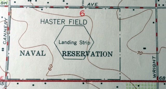
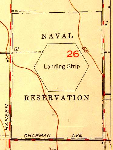
"Haster Field Naval Reservation Landing Strip" was still depicted on the 1949 USGS topo map (courtesy of Kevin Walsh),
so apparently the property was still owned by the military at that point, but it may not have still been an active airfield.
The map depicted the airfield as a hexagonal landing mat.
A 1953 aerial view depicted Haster Field's hexagonal landing area, but without any sign of current usage.
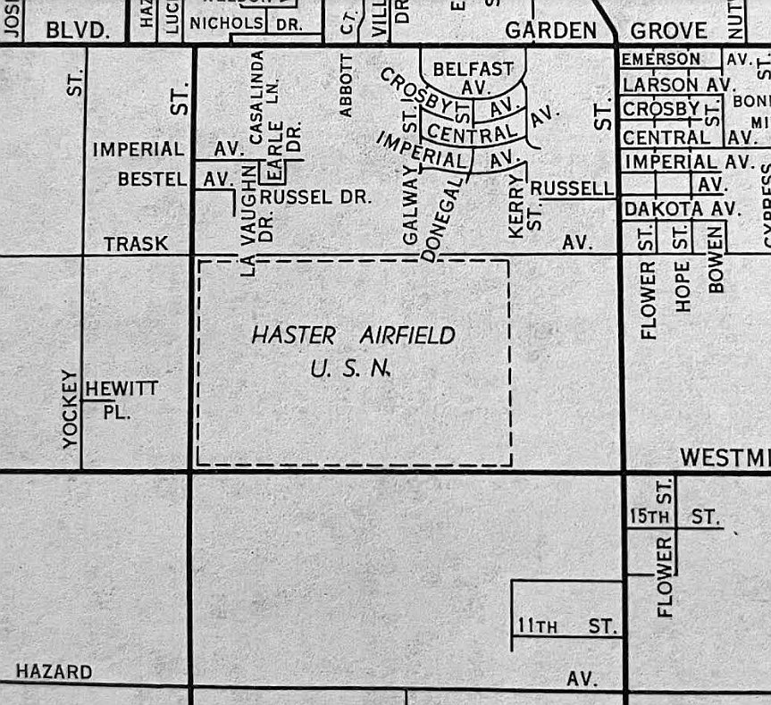
A 1954 street map (courtesy of Kevin Walsh) depicted the rectangular property outline of “Haster Airfield U.S.N.”
Haster Farm was apparently reused as a civil airfield,
as that is how it was depicted on the September 1955 San Diego Sectional Aeronautical Chart (courtesy of Chris Kennedy).
The Aerodromes table described the airfield as consisting of a 1,400' "All way" asphalt landing area,
along with the remarks "Very poor. Heavy overgrowth of weeds."
Bob Cannon recalled, "I have a 1956 LA Local [Aeronautical Chart].
Haster Farm is listed as 'Very poor. Heavy overgrowth of weeds'.
I show in my log book that on 6/30/56 I landed at Haster Farm with the notation, 'into weeds'."
Rick Truofreh recalled, “I flew with my father for the first time in my life at the age of 4 (1958) from the Haster Field,
North of Westminster (17th) Avenue & East of Canery Road (Magnolia Avenue).
There were about 6 various airplanes stored there back then.
We flew in a Piper Cub, with the pilot in the front, my Dad in the second seat tandem, and I was packed into the leather luggage sling behind my Dad.
What a thrill that was! No seatbelt!”
TheHaster airfield was evidently closed at some point between 1958-59,
as it was no longer depicted at all on the September 1959 San Diego Sectional Aeronautical Chart (courtesy of Chris Kennedy)
or subsequent aeronautical charts.
As depicted on a 1959 street map (courtesy of Scott O'Donnell),
the Haster Farm airfield was bounded by Trask Avenue on the north, Westminster Avenue on the south,
Brookhurst Avenue on the east, and Cannery Street on the west.
Rick Truofreh recalled, “In 1962, my parents bought a new tract home on the site
adjacent to the open field where they later built the 22 freeway, Atlantis & Garden Grove Park.
In the summer of 1962, a brave pilot set his Piper Cub down on what remained of the old runway,
as my Sister & I watched on from the fence surrounding our housing tract. It brought back memories.”
According to John Voss, Haster Farm NOLF eventually became the location
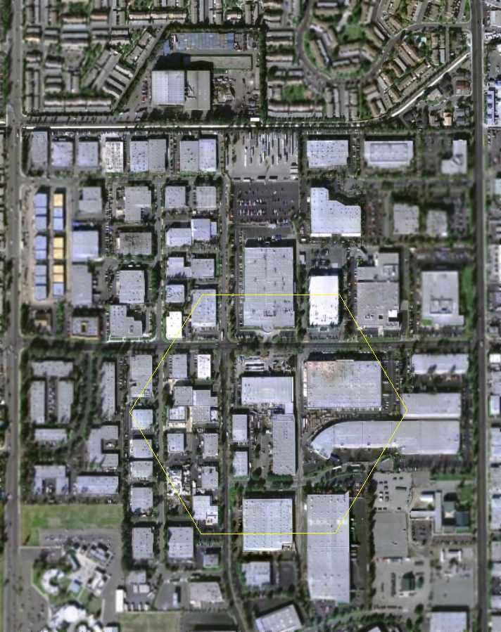
of Haster High School (later renamed Bolsa Grande High School) and Garden Grove Park.
The 22 Freeway now bisects the northern portion of the site.
A 1972 aerial view showed the high school on the site, with not a trace of the former airfield.
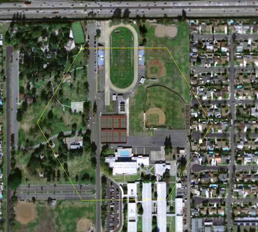
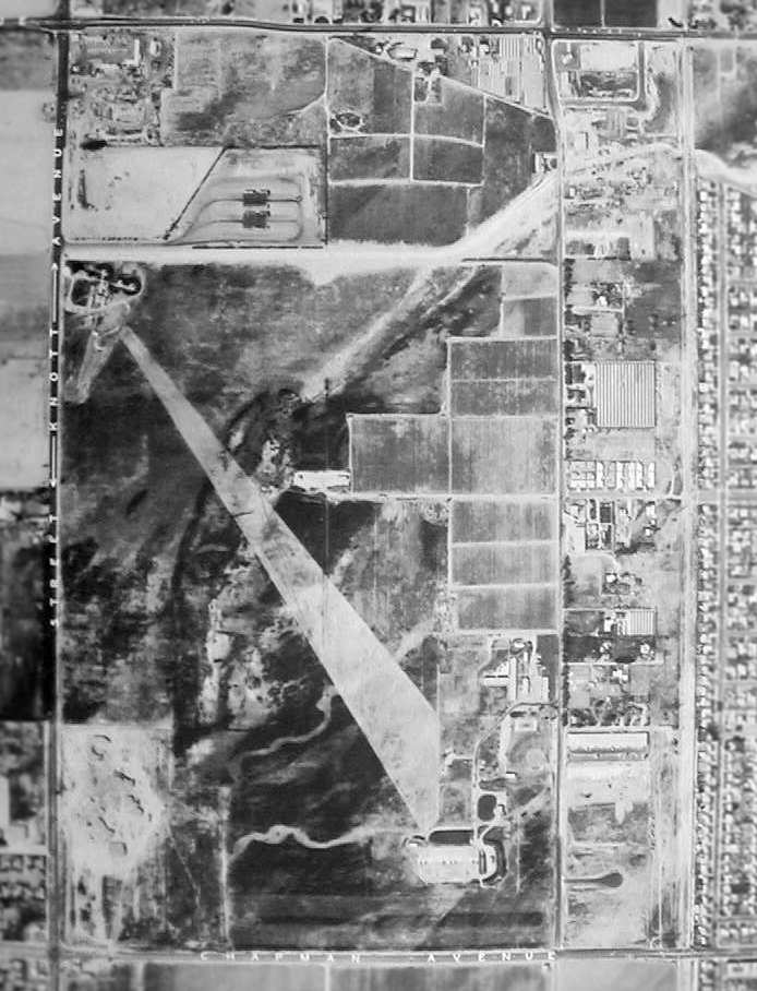
The outline of the Haster Farm airfield, as annotated by Chris Kennedy over a 2006 aerial photo of the site.
Not a trace remains of the former airfield.
____________________________________________________
Since this site was first put on the web in 1999, its popularity has grown tremendously.
If the total quantity of material on this site is to continue to grow,
it will require ever-increasing funding to pay its expenses.
Therefore, I request financial contributions from site visitors,
to help defray the increasing costs of the site
and ensure that it continues to be available & to grow.
What would you pay for a good aviation magazine, or a good aviation book?
Please consider a donation of an equivalent amount, at the least.
This site is not supported by commercial advertising –
it is purely supported by donations.
If you enjoy the site, and would like to make a financial contribution,
you
may use a credit card via
![]() :
:
Please consider checking the box to make a monthly donatation.
For a mailing address to send a check, please contact me at: paulandterryfreeman@gmail.com
If you enjoy this web site, please support it with a financial contribution.
This site covers airfields in all 50 states.