
Abandoned & Little-Known Airfields
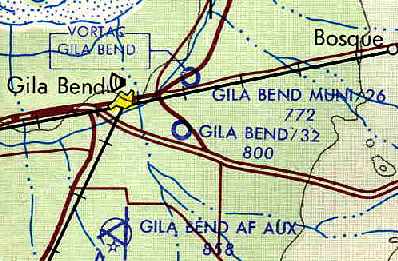
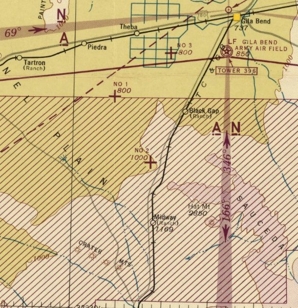
Arizona: Gila Bend area
© 2002, © 2024 by Paul Freeman. Revised 3/8/24.
____________________________________________________
Please consider a financial contribution to support the continued growth & operation of this site.
Ajo AAF Aux #1 / Williams AF Aux #1 / Luke AF Aux #7 SW (revised 4/14/18) - Ajo AAF Aux #2 / Williams AF Aux #2 / Luke AF Aux #8 (revised 6/20/19)
Ajo AAF Aux #3 / Williams AF Aux #3 / Luke AF Aux #9 (revised 2/3/21) - Gila Bend Airport (1st location) (added 5/6/15) - Gila Bend Airport (2nd location) / Hunts Airport (added 5/8/15)
Gila Bend Airport (3rd location) (revised 11/19/16) - Gila Bend AAF Aux #4 / Williams AF Aux #4 / Luke AF Aux #10 (revised 2/3/21)
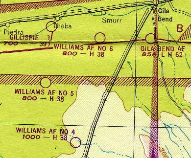
Gila Bend AAF Aux #5 / Williams AF Aux #5 / Luke AF Aux #11 (revised 3/8/24) - Gila Bend AAF Aux #6 / Williams AF Aux #6 (revised 4/26/14)
____________________________________________________
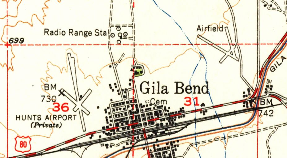
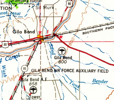
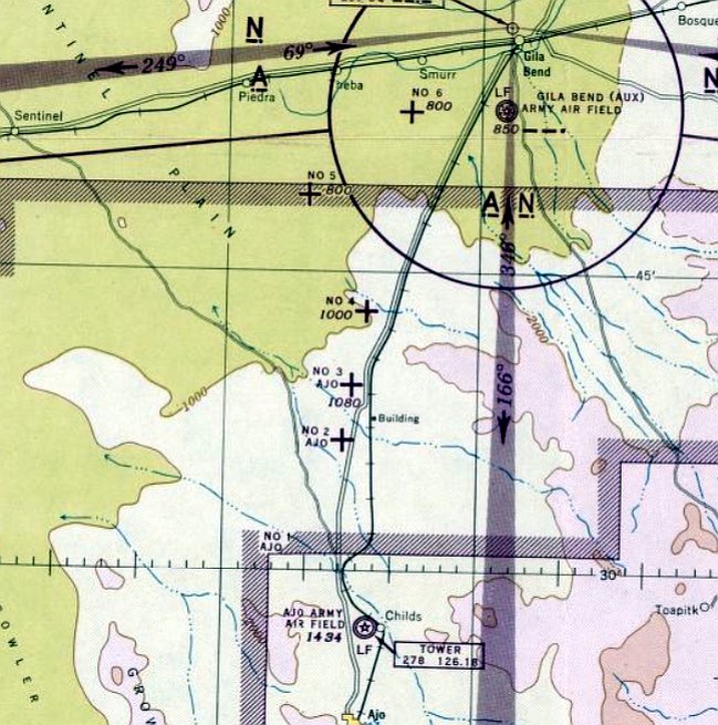
Gila Bend Airport (1st location), Gila Bend, AZ
32.957, -112.706 (West of Gila Bend AF Aux, AZ)
A 10/28/47 USGS aerial view of the original location of the Gila Bend Airport, on the northeast side of town.
The original airport for the town of Gila Bend Airport was located northeast of the town.
The Gila Bend Airport may have been established at some point between 1945-47,
as it was not yet depicted on the 1945 Phoenix Sectional Chart (courtesy of John Voss).
The earliest depiction which has been located of the Gila Bend Airport was a 10/28/47 USGS aerial photo.
It depicted the field as having 3 very rough unpaved runways.
There were no buildings or aircraft visible on the airport.
The only topo map depiction which has been located of the original location of the Gila Bend Airport was on the 1951 USGS topo map,
which depicted 3 runways on the northeast side of town labeled simply as “Airfield”.
8
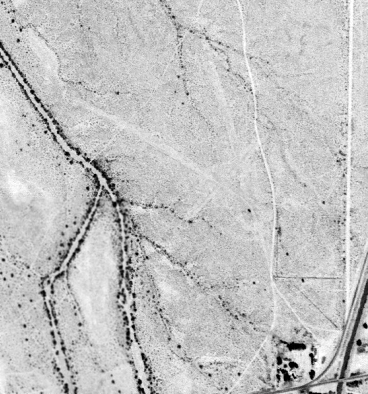
A 3/23/53 USGS aerial view of the original location of the Gila Bend Airport showed the 3 runways to be very deteriorated.
At some point between 1951-56, the Gila Bend Airport to the northeast was apparently closed,
as the 1956 Phoenix Sectional Chart depicted the Gila Bend Airport to the northwest of the town (the location previously labeled as Hunts Airport).
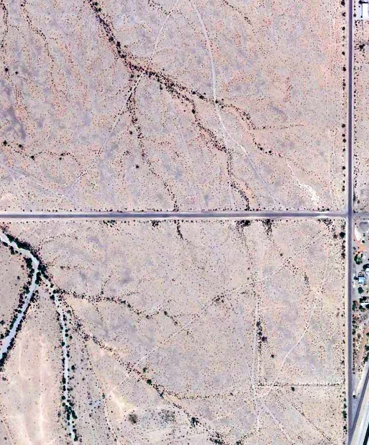
A 2014 aerial view showed Indian Road had been built heading west across the site of the original Gila Bend Airport.
Although the site otherwise remained open desert, no traces of the 3 runways were still recognizable.
The site of the original Gila Bend Airport is located west of the intersection of Stout Road & Indian Road.
Thanks to Mike Jamison for pointing out this airfield.
____________________________________________________
Hunts Airport / Gila Bend Airport (2nd location), Gila Bend, AZ
32.95, -112.725 (West of Gila Bend AF Aux, AZ)
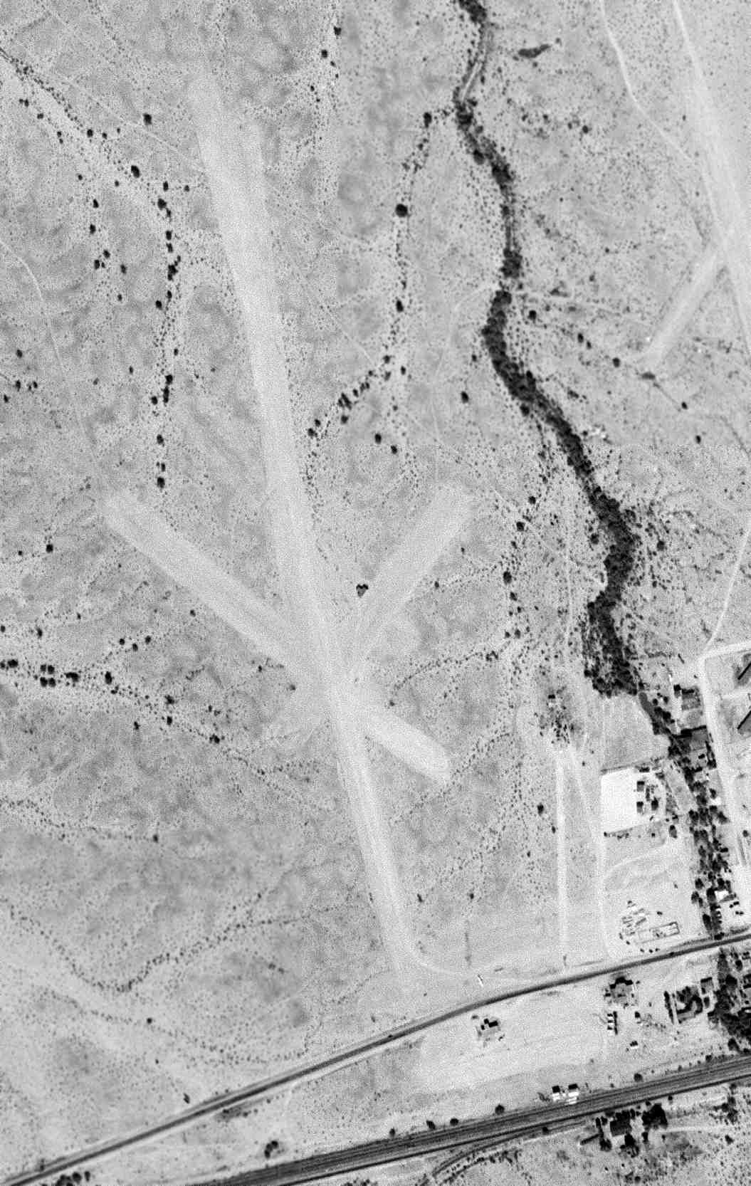
A 10/28/47 USGS aerial view of Hunts Airport, on the northwest side of the town of Gila Bend.
This small general aviation airport on the northwest side of the town of Gila Bend was evidently established at some point between 1945-47,
as it was not yet depicted on the 1945 Phoenix Sectional Chart (courtesy of John Voss).
The earliest depiction which has been located of the Hunts Airport was a 10/28/47 USGS aerial photo.
It depicted the field as having 3 very rough unpaved runways.
There was 1 T-hangar visible to the northeast of the runway intersection, but no aircraft were visible on the airport.
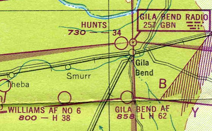
The earliest aeronautical chart depiction which has been located of Hunts Airport was on the 1949 Phoenix Sectional Chart,
which depicted Hunts as having a 3,400' unpaved runway.
The only topo map depiction which has been located of Hunts Airport was on the 1951 USGS topo map,
which depicted 3 runways on the northwest side of town, and noted it as a private airfield.
There was 1 small building depicted to the northeast of the runway intersection.
A 3/23/53 USGS aerial view of Hunts Airport showed the runway configuration remained the same as seen in 1949.
The T-hangar had evidently been removed at some point between 1949-53,
and 1 small building added to the east of the runway intersection.
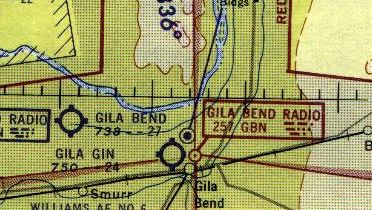
Hunts Airport may have been renamed for a while as the Gila Bend Airport,
as that is how the airfield to the northwest of the town of Gila Bend was labeled on the 1956 Phoenix Sectional Chart.
It depicted the Gila Bend Airport to the northwest as having a 2,700' unpaved runway.
The last depiction which has been located of the 2nd location of Gila Bend Airport (to the northwest) was on the 1958 USGS topo map.
At some point between 1958-62, the 2nd location of the Gila Bend Airport (to the northwest) was apparently closed,
as the 1962 USGS topo map depicted the Gila Bend Airport in a new location to the southeast of the town.
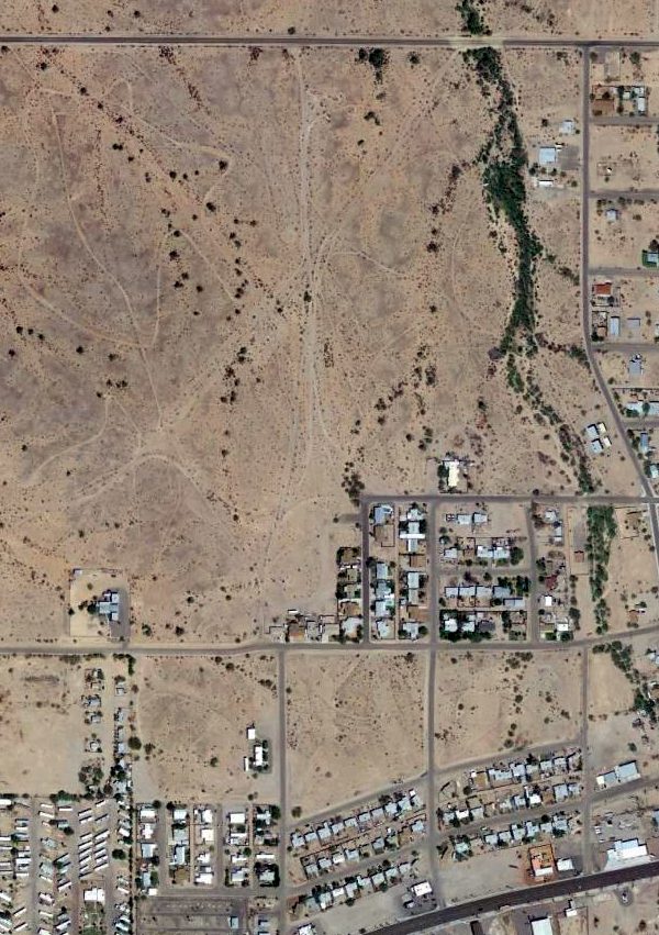
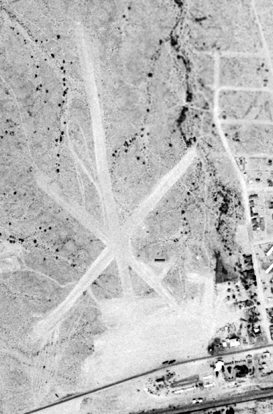
A 2014 aerial view of the site of Hunts Airport / Gila Bend Airport showed that housing had covered the southeast portion,
but the outline of several runways was stiill recognizable on the northwest portion.
The site of Hunts Airport is located west of the intersection of Stout Road & Indian Road.
Thanks to Mike Jamison for pointing out this airfield.
____________________________________________________
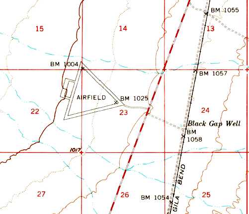
Gila Bend Airport (3rd location), Gila Bend, AZ
32.935, -112.685 (West of Gila Bend AF Aux, AZ)
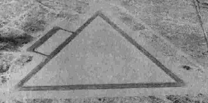
A 5/31/61 aerial view depicted the 3rd location of the Gila Bend Airport.
At some point between 1958-60, the 2nd location of the Gila Bend Airport (northeast of the town)
was replaced by a 3rd location, southeast of the town.
Anne Miller recalled, “I know that the Gila Bend Airport [3rd location] was open in 1960
because I flew in there on my first solo cross country from Tucson on the way to Phoenix.”
The earliest depiction which has been located of the 3rd location of the Gila Bend Airport was a 5/31/61 aerial photo.
It depicted the field as having 2 unpaved runways, with a hangar & one single-engine aircraft on the east side.
The earliest topo map depiction which has been located of the 3rd location of the Gila Bend Airport was on the 1962 USGS topo map.
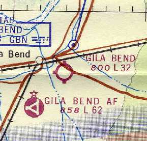
The earliest aeronautical chart depiction which has been located of the 3rd location of the Gila Bend Airport
was on the 1964 Phoenix Sectional Chart (courtesy of Chris Kennedy).
It described Gila Bend as having a 3,200' unpaved runway.
The August 1971 USAF Tactical Pilotage Chart (courtesy of Chris Kennedy)
depicted both the "Gila Bend" Airport (southeast of the town of Gila Bend),
as well as the new "Gila Bend Muni" Airport (northeast of the town).
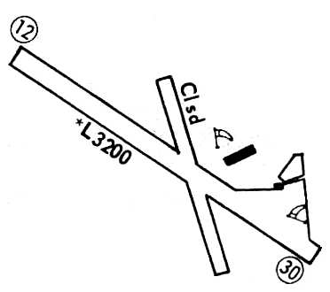
The 1972 Flight Guide (courtesy of Chris Kennedy) depicted the 3rd location of Gila Bend Airport as having a 3,200' runway 12/30,
(as well as a closed, shorter crosswind runway),
along with a single building (a hangar?) just northeast of the runway intersection.
The Gila Bend Airport at this location was apparently closed at some point between 1972-73,
as it was no longer depicted at all on the 1973 USGS topo map nor listed in the 1973 Flight Guide (courtesy of Fred Udall).
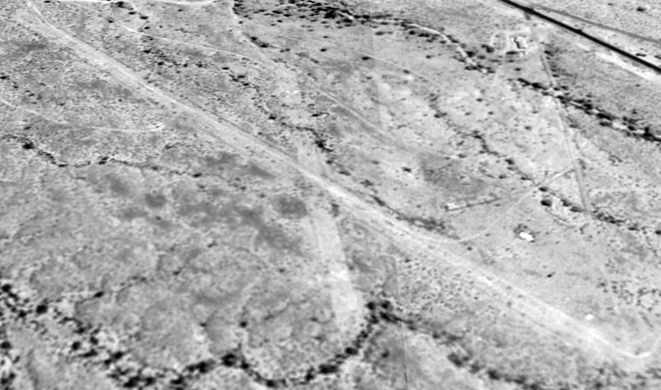
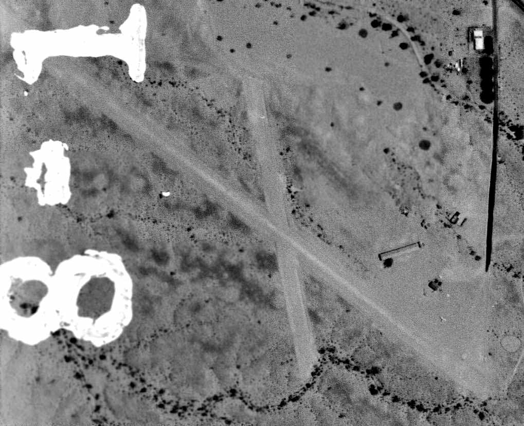
As seen in a 1996 USGS aerial view looking north, the 2 dirt runways of the 3rd location of the Gila Bend Airport were still quite recognizable,
with closed-runway "X" symbols still visible on both ends of the north/south runway.
The remains of the foundation of the hangar still existed, just east of the runway intersection.
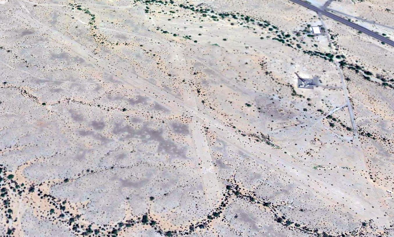
A 2014 aerial view looking north showed the 2 dirt runways of the 3rd location of the Gila Bend Airport were still quite recognizable,
with the closed-runway "X" symbol still barely recognizable on the south end of the shorter runway.
Thanks to Chris Kennedy for pointing out this airfield.
____________________________________________________
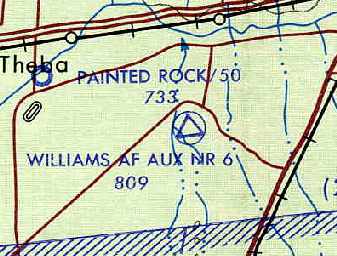
Gila Bend AAF Auxiliary #6 / Williams Air Force Aux #6, Gila Bend, AZ
32.886, -112.816 (West of Gila Bend AF Aux, AZ)
A 6/23/43 aerial view looking north at “Gila Bend AAF Auxiliary #6”
from the 1945 AAF Airfield Directory (courtesy of Scott Murdock).
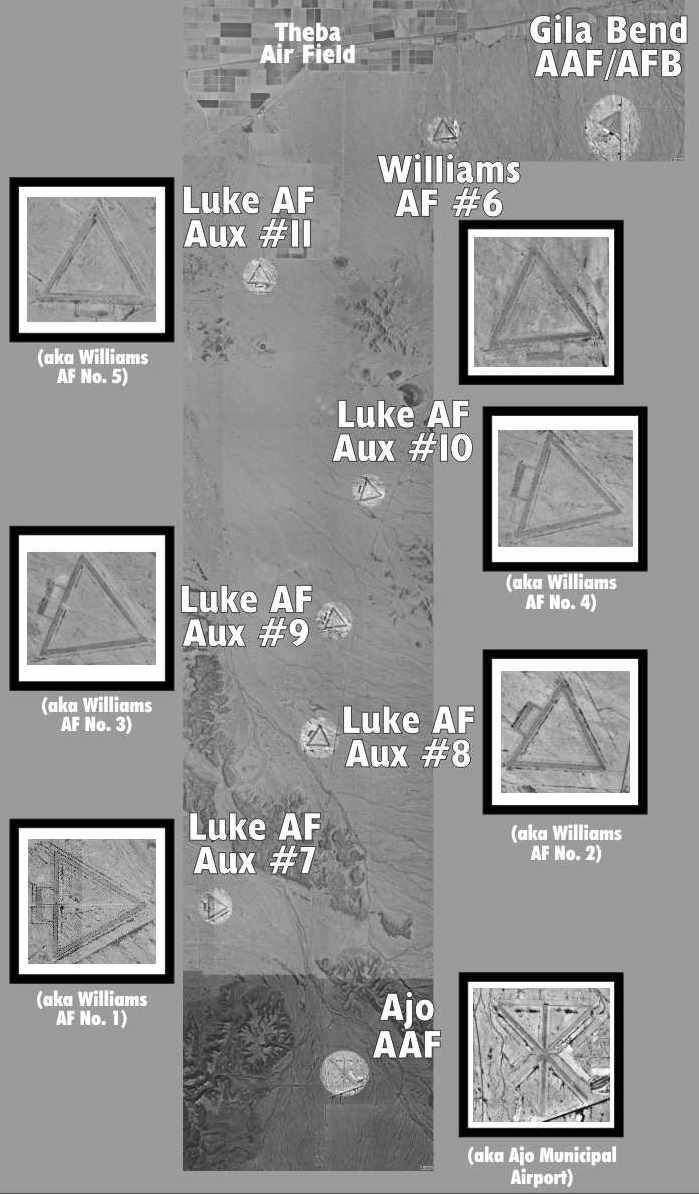
This field is one of a string of WW2 AAF training airfields along Rt.85 between Gila Bend & Ajo.
It was built during WW2 as one of a large number of satellite airfields for Ajo AAF & Gila Bend AAF.
It is located just west of the still-operational Gila Bend Air Force Auxiliary Airfield.
The earliest depiction which has been located of this field
was a 6/23/43 aerial view looking north from the 1945 AAF Airfield Directory (courtesy of Scott Murdock).
It depicted “Gila Bend AAF Auxiliary #6” as having 3 paved runways with a paved ramp on the south side.
The 1945 AAF Airfield Directory (courtesy of Scott Murdock) described “Gila Bend AAF Auxiliary #6”
as a 640 acre square property having 3 bituminous 3,654' runways.
The field was said to not have any hangars,
to be owned by the U.S. Government, and operated by the Army Air Forces.
This field was listed as Gila Bend Aux AAF #6 in a directory of AZ Airports
in the 5/47 issue of Arizona Highways (courtesy of George Miller),
which described the field as being unattended, and the longest runway as being 3,700'.
An 11/1/47 USGS aerial view depicted Gila Bend AAF Auxiliary #6 as intact but deteriorated, without any signs of recent use.
The earliest aeronautical chart depiction which has been located of this field was on the 1949 Phoenix Sectional Chart (courtesy of Chris Kennedy).
It labeled the field as "Williams AF Aux #6".
The 1950 USGS topo map depicted the 3 runways & ramp, labeled simply as "Airfield".
It was still depicted as an active Air Force field on the 1956 Phoenix Sectional Chart (courtesy of John Voss).
It was depicted as "Williams AF #6" on the 1969 USGS topo map.
"Williams AF Aux #6" was still depicted as an active airfield
on the August 1971 USAF Tactical Pilotage Chart (courtesy of Chris Kennedy).
Williams AF Aux #6 was evidently closed at some point between 1971-77,
as it was labeled “Closed” on the 1977 Phoenix Sectional Chart,
and labeled generically as “Landing Field” on the 1981 USGS topo map.
The 3 runways & ramp of Williams Aux #6 were still depicted on the 1991 USGS topo map, labeled merely as “Landing Field”.
The overall property was labeled as “Luke Air Force Range”.
A 1996 USGS aerial view depicted Gila Bend AAF Auxiliary #6 as intact but deteriorated.
A remarkable composite picture, in which David Brooks has superimposed close-up views
of the numerous former satellite airfields in the Gila Bend area over the 1992 USGS aerial photo.
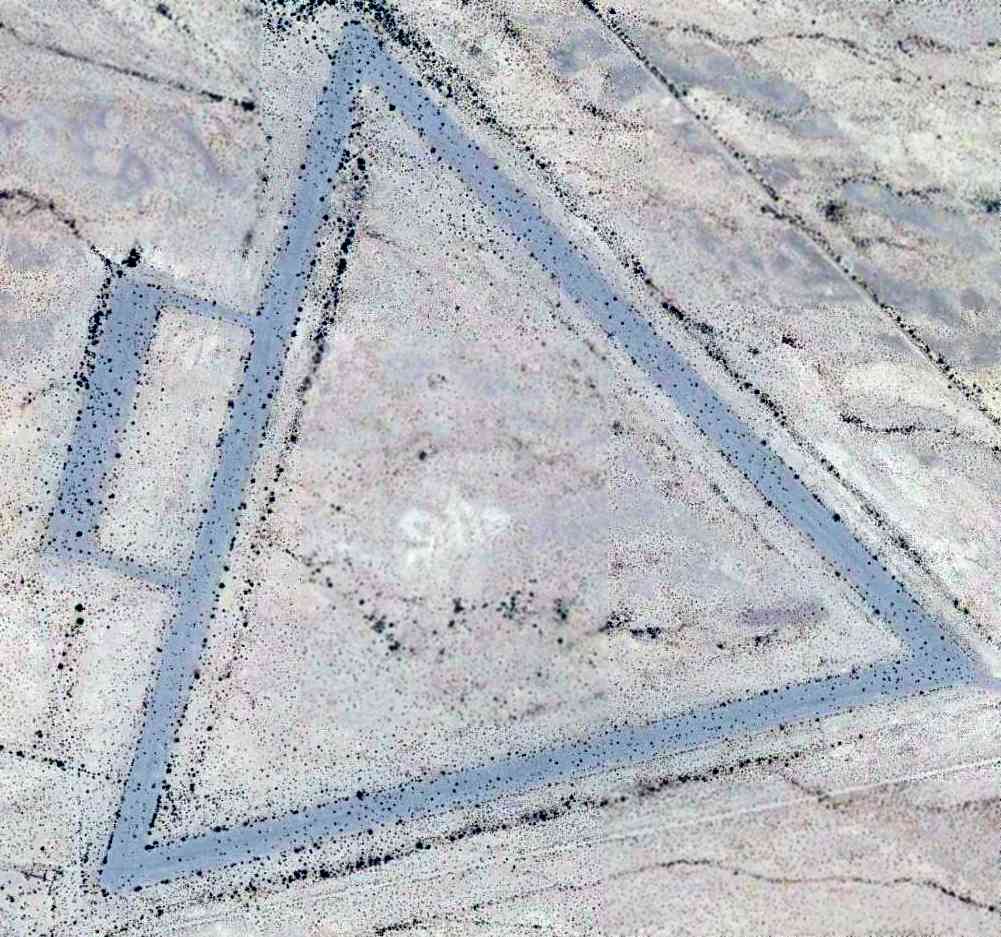
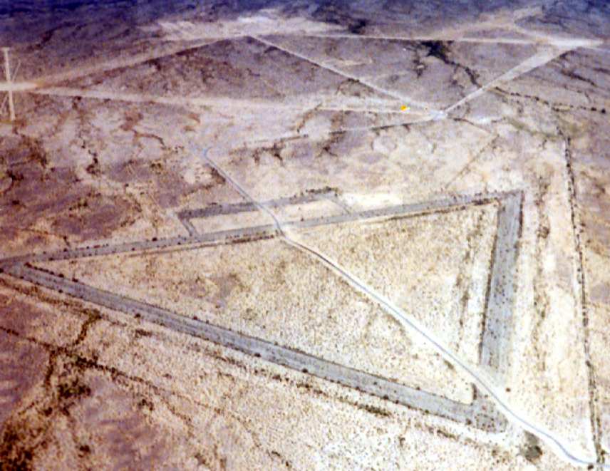
A February 2007 aerial view by Ken Calman, looking southeast at Williams Aux #6.
The remains of the three 4,000' runways still existed, as well as the ramp area.
Ken observed that among the many WW2-era airfields in this area,
this one is “the only one I know of that looks to be in such good condition, as if it's being used frequently.
This lies just inches west of the airspace of the Gila Bend Air Force Auxiliary Airport.”
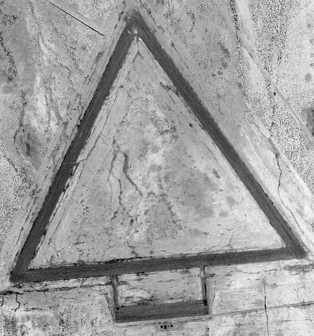
A 5/26/12 aerial view depicted Gila Bend AAF Auxiliary #6 as deteriorated but still remarkably intact for a 70 year old airfield.
____________________________________________________
Gila Bend AAF Aux #5 / Williams AF Aux #5 / Luke Air Force Aux #11, Gila Bend, AZ
32.818, -112.915 (Southwest of Gila Bend AF Aux, AZ)
A 6/23/43 aerial view looking north at “Gila Bend AAF Auxiliary #5”
from the 1945 AAF Airfield Directory (courtesy of Scott Murdock).
This field is one of a string of WW2 AAF training airfields along Route 85 between Gila Bend & Ajo.
It was built during WW2 as one of a large number of satellite airfields for Ajo AAF & Gila Bend AAF.
No airfield was yet depicted at this location on the February 1943 Phoenix Sectional Chart.
The earliest depiction which has been located of Gila Bend Aux AAF #5
was a 6/23/43 aerial view looking north from the 1945 AAF Airfield Directory (courtesy of Scott Murdock).
It depicted “Gila Bend AAF Auxiliary #5” as having 3 paved runways with a paved ramp on the south side.
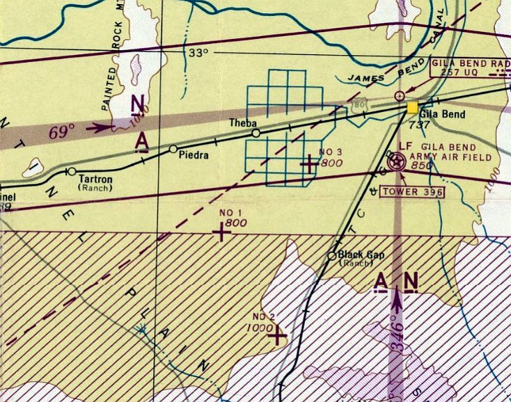
The earliest aeronautical chart depiction which has been located of this airfield was on the March 1944 Phoenix Sectional Chart.
It depicted an auxiliary airfield labeled simply as “No 1”.
The 1945 AAF Airfield Directory (courtesy of Scott Murdock) described “Gila Bend AAF Auxiliary #5”
as a 640 acre square property having 3 bituminous 3,654' runways.
The field was said to not have any hangars, to be owned by the U.S. Government, and operated by the Army Air Forces.
The September 1945 Phoenix Sectional Chart depicted “No 5” as an auxiliary airfield.
The 5/47 issue of Arizona Highways (courtesy of George Miller) described Gila Bend Aux AAF #5 as being unattended, and the longest runway being 3,700'.
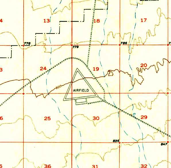
The 1950 USGS topo map depicted the 3 runways & ramp, labeled simply as "Airfield".
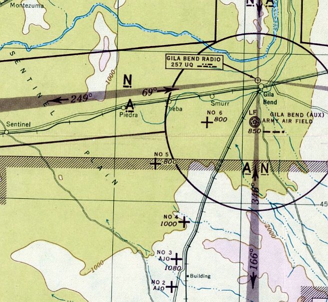
"Williams AF #5" was still depicted as an active Air Force Field on the 1956 Phoenix Sectional Chart (courtesy of John Voss).
It was depicted as "Luke AF #11" on the 1969 USGS topo map.
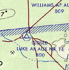
This airfield apparently was closed by 1971, as it was labeled "Closed Luke AF Aux #11"
on the August 1971 USAF Tactical Pilotage Chart (courtesy of Chris Kennedy).
Williams AF Aux #11 was evidently closed at some point between 1971-77,
as it was labeled “Closed” on the 1977 Phoenix Sectional Chart,
and labeled generically as “Landing Field” on the 1981 USGS topo map.

The 3 runways & ramp of Luke Aux #11 were still depicted on the 1991 USGS topo map, labeled merely as “Landing Strips”.
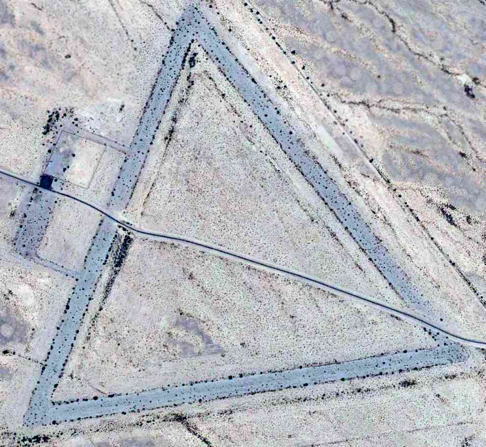
The 1996 USGS aerial photo showed the field remained intact.
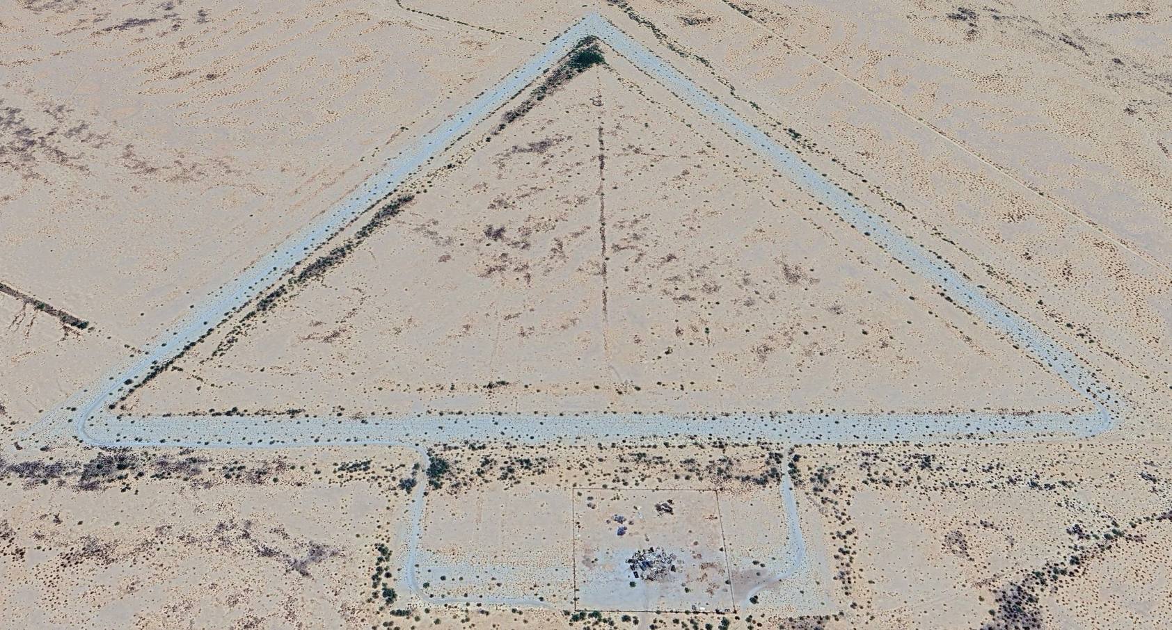
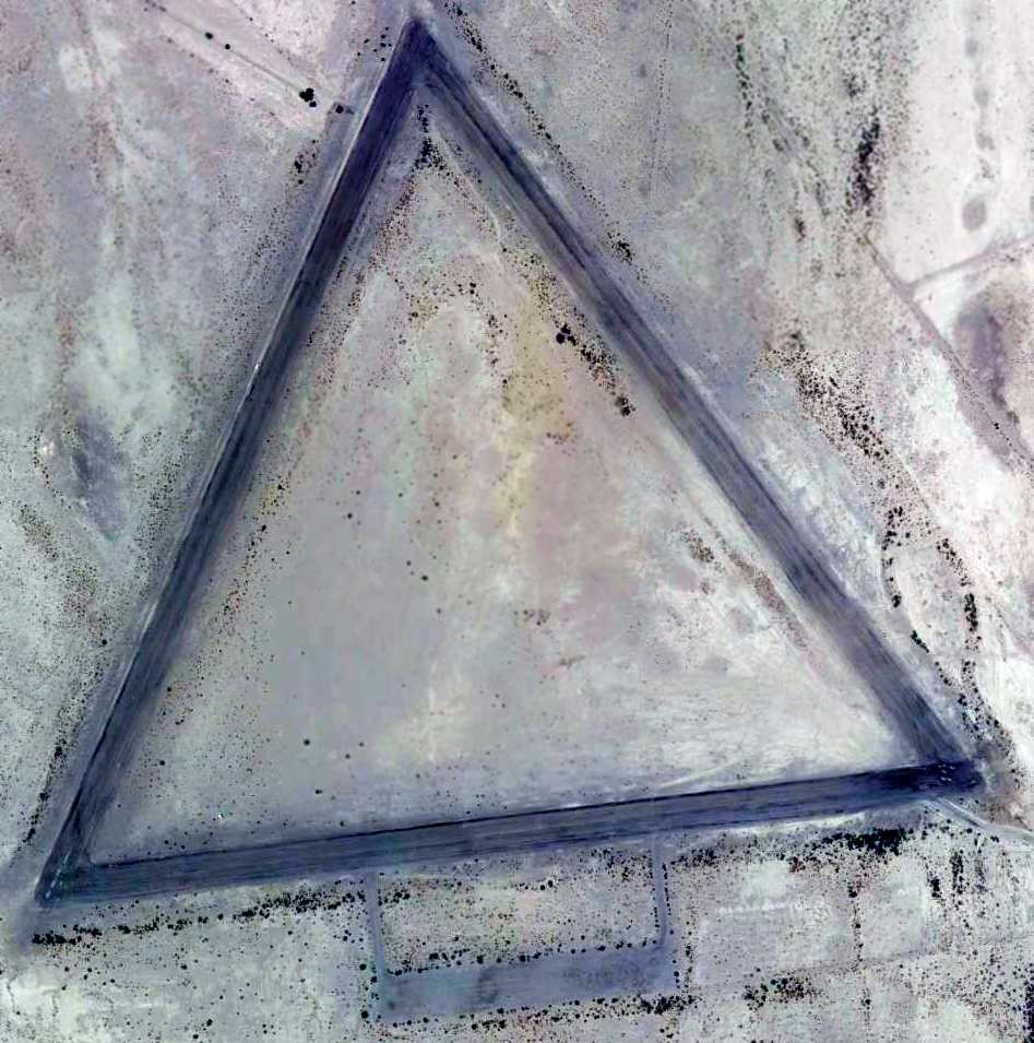
A 2023 aerial view looking north showed the remains of three 4,000' runways still existed at the site of Gila Bend Aux AAF #5.
____________________________________________________
Gila Bend AAF Aux #4 / Williams AF Aux #4 / Luke Air Force Aux #10, Gila Bend, AZ
32.72, -112.854 (Southwest of Gila Bend AF Aux, AZ)
A 6/23/43 aerial view looking east at “Gila Bend AAF Auxiliary #4”
from the 1945 AAF Airfield Directory (courtesy of Scott Murdock).
One of a string of WW2 AAF training airfields along Rt.85 between Gila Bend & Ajo.
Built during WW2 as one of a large number of satellite airfields for Ajo AAF & Gila Bend AAF.
The earliest depiction which has been located of this field
was a 6/23/43 aerial view looking east from the 1945 AAF Airfield Directory (courtesy of Scott Murdock).
It depicted “Gila Bend AAF Auxiliary #4” as having 3 paved runways with a paved ramp on the west side.
Gila Bend Auxiliary Field #4 was not yet depicted on the March 1944 Phoenix Sectional Chart.
The earliest depiction which has been located of Gila Bend Auxiliary #4 was on the September 1945 Phoenix Sectional Chart.
The 1945 AAF Airfield Directory (courtesy of Scott Murdock) described “Gila Bend AAF Auxiliary #4”
as a 640 acre square property having 3 bituminous 3,654' runways.
The field was said to not have any hangars, to be owned by the U.S. Government, and operated by the Army Air Forces.
This field was listed as Gila Bend Aux AAF #4 in a directory of AZ Airports
in the 5/47 issue of Arizona Highways (courtesy of George Miller),
which described the field as being unattended, and the longest runway as being 3,700'.
It was still depicted as an active Air Force Field, "Williams AF #4"
on the 1956 Phoenix Sectional Chart (courtesy of John Voss).
The 1958 USGS topo map depicted the 3 runways & ramp, labeled simply as "Airfield".
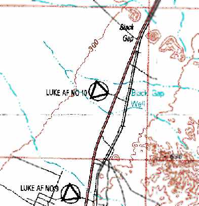
It was depicted as "Luke AF #10" on the 1969 USGS topo map.
This airfield apparently was closed at some point between 1956-71,
as it was labeled closed on the August 1971 USAF Tactical Pilotage Chart (courtesy of Chris Kennedy).
The 1981 USGS topo map still depicted the 3 runways, but labeled them simply as “Landing Field”.
Strangely, the 1986 USGS topo map did not depict the airfield at all, even though the 3 runways were still quite intact,
and the same topo map depicted some of the other nearby abandoned auxiliary airfields.
As seen in the 1996 USGS aerial photo, the remains of three 4,000' runways still existed.
A 5/26/12 aerial view showed Gila Bend Aux AAF #4 remained in the same condition.
____________________________________________________
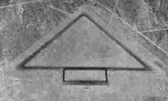
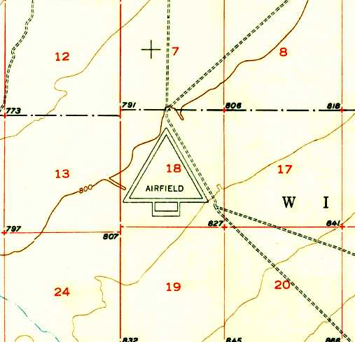
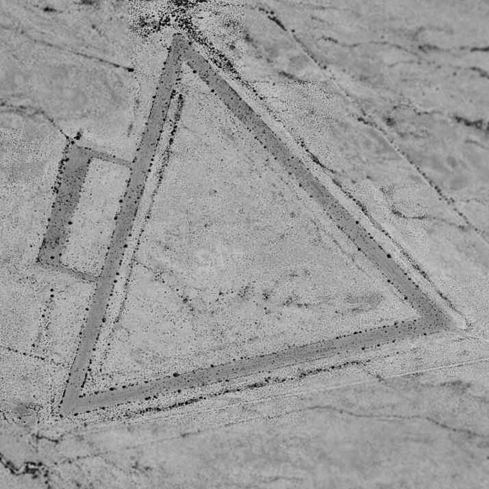
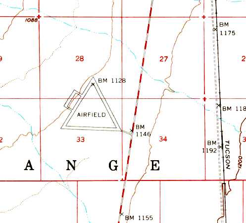
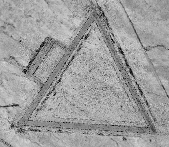
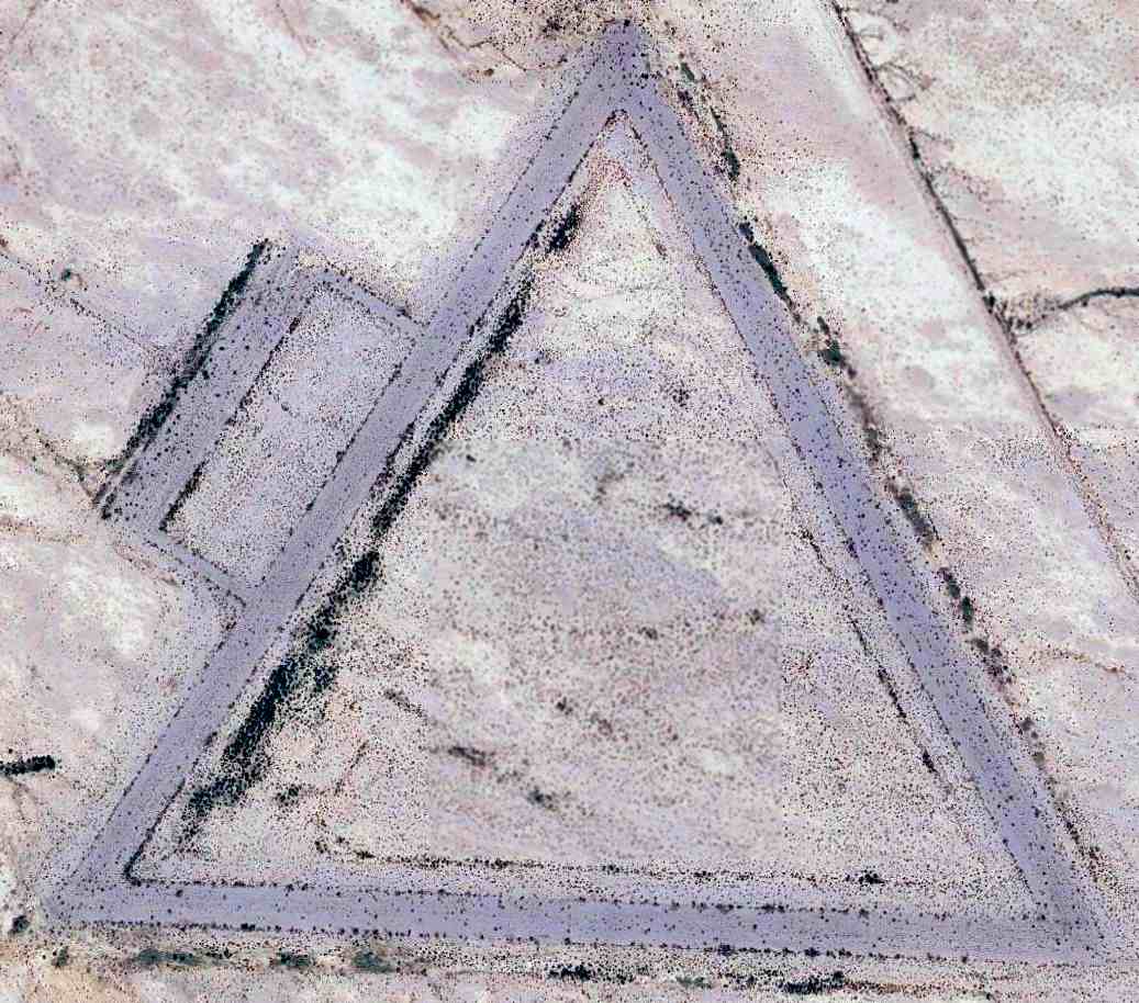
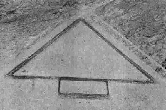
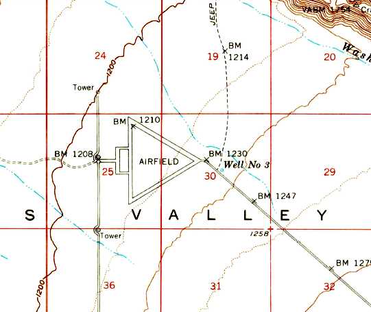
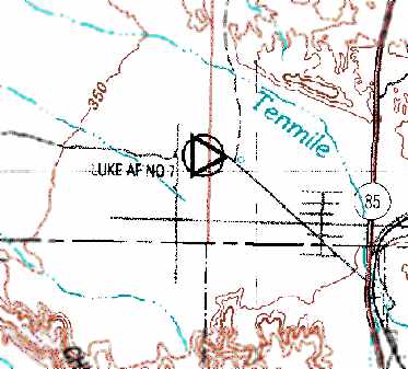
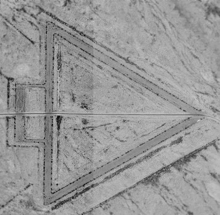
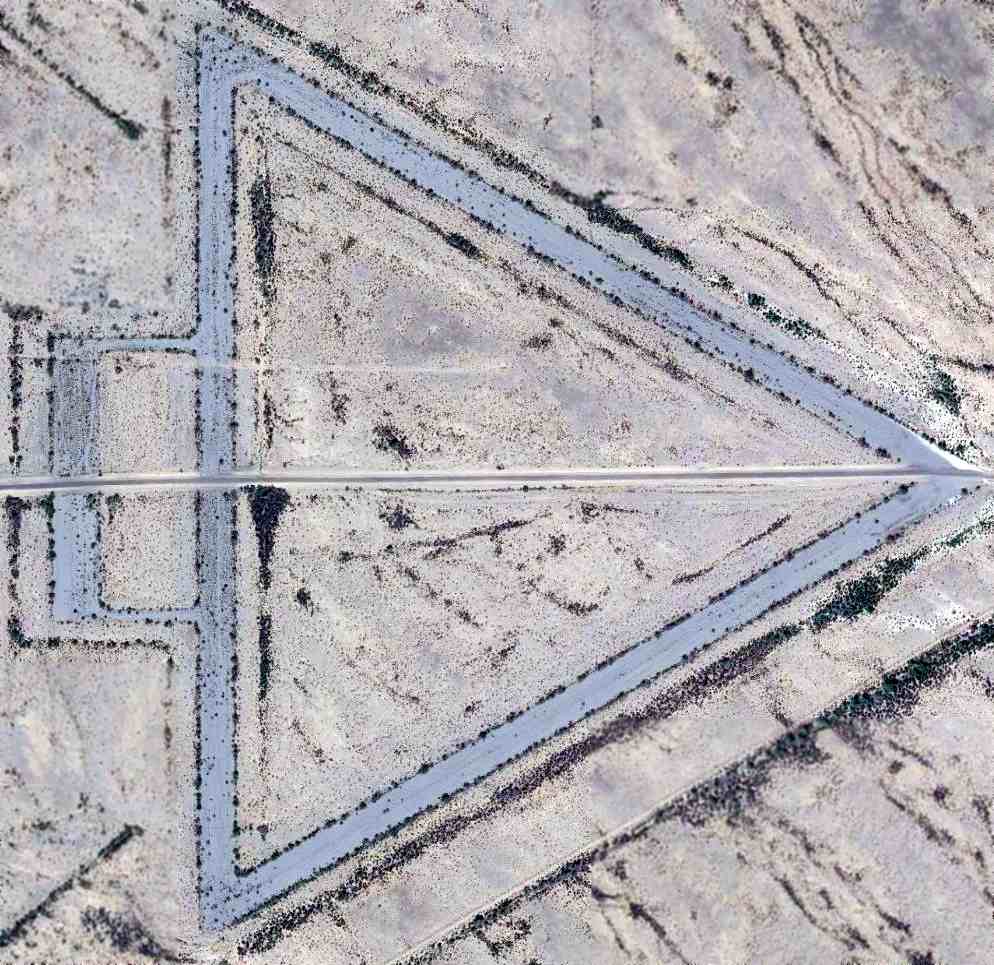
Ajo AAF Auxiliary #3 / Williams AF Auxiliary #3/ Luke Air Force Auxiliary #9, Gila Bend, AZ
32.66, -112.87 (Southwest of Gila Bend AF Aux, AZ)
A 6/23/43 aerial view looking north at “Ajo AAF Auxiliary (Luke Landing Field #3)”
from the 1945 AAF Airfield Directory (courtesy of Scott Murdock).
This airfield is one of a string of WW2 AAF training airfields along Rt.85 between Gila Bend & Ajo.
It was built during WW2 as one of a large number of satellite airfields for Ajo AAF & Gila Bend AAF.
The earliest depiction which has been located of this field
was a 6/23/43 aerial view looking north from the 1945 AAF Airfield Directory (courtesy of Scott Murdock).
It depicted “Ajo AAF Auxiliary (Luke Landing Field #3)” as having 3 paved runways with a paved ramp on the west side.
Ajo Auxiliary Field #3 was not yet depicted on the March 1944 Phoenix Sectional Chart.
The earliest depiction which has been located of Ajo Auxiliary #3 was on the September 1945 Phoenix Sectional Chart.
The 1945 AAF Airfield Directory (courtesy of Scott Murdock) described “Ajo AAF Auxiliary (Luke Landing Field #3)”
as a 600 acre triangular property having 3 bituminous 3,650' runways.
The field was said to not have any hangars,
to be owned by the U.S. Government, and operated by the Army Air Forces.
This field was listed as Ajo Aux AAF #3 in a directory of AZ Airports
in the 5/47 issue of Arizona Highways (courtesy of George Miller),
which described the longest runway as 3,700', and being unattended.
It was still depicted as an active Air Force Field, "Williams AF #3"
on the 1956 Phoenix Sectional Chart (courtesy of John Voss).
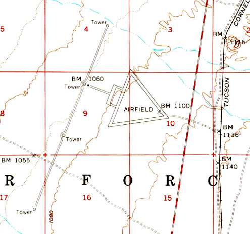
The 1958 USGS topo map depicted the 3 runways & ramp, labeled simply as "Airfield",
as well as the bomb scoring towers adjacent to the west.
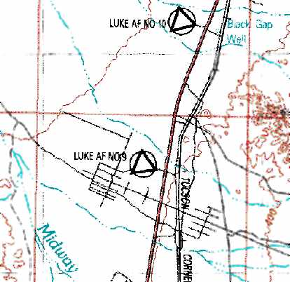
It was depicted as "Luke AF #9" on the 1969 USGS topo map.
This airfield apparently was closed at some point between 1956-71,
as it was labeled closed on the August 1971 USAF Tactical Pilotage Chart (courtesy of Chris Kennedy).
The 1981 USGS topo map still depicted the 3 runways, but labeled them simply as “Landing Field”.
Strangely, the 1986 USGS topo map did not depict the airfield at all,
even though the 3 runways were still quite intact,
and the same topo map depicted some of the other nearby abandoned auxiliary airfields.
As seen in the 1996 USGS aerial photo, the remains of three 4,000' runways still existed.
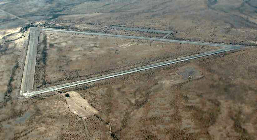
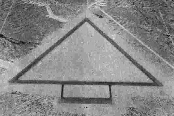
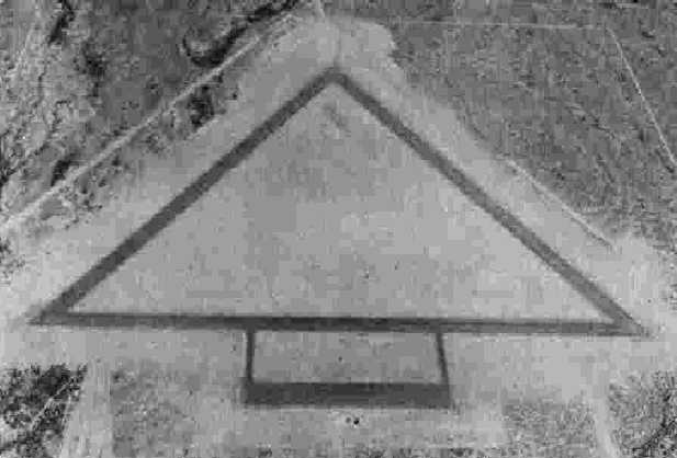
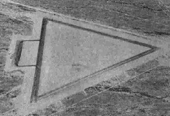
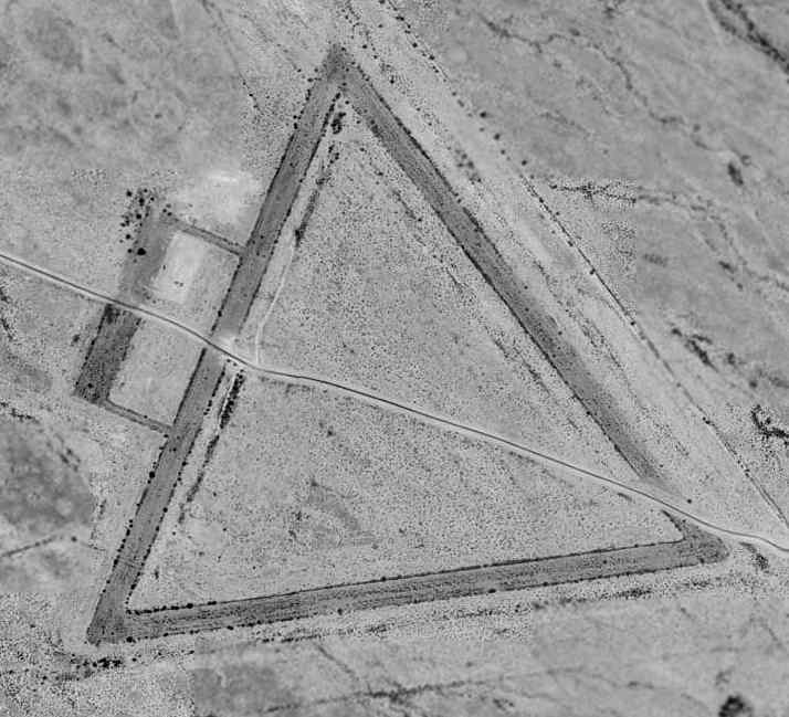
A 1997 aerial view by Steve Hoza, looking west at Ajo Aux #3 / Luke Aux #9.
The photo is courtesy of Steve Hoza, from the book "Best Place in the Country", by Mike & Steve Hoza.
Several large target circles for aircraft bombing practice are cut into the desert just west of the airfield,
and a road leading to the targets bisected the airfield.
The targets are reportedly still used by fighters from Luke AFB.
A 5/26/12 aerial view showed Ajo Aux AAF #3 remained in the same condition.
____________________________________________________
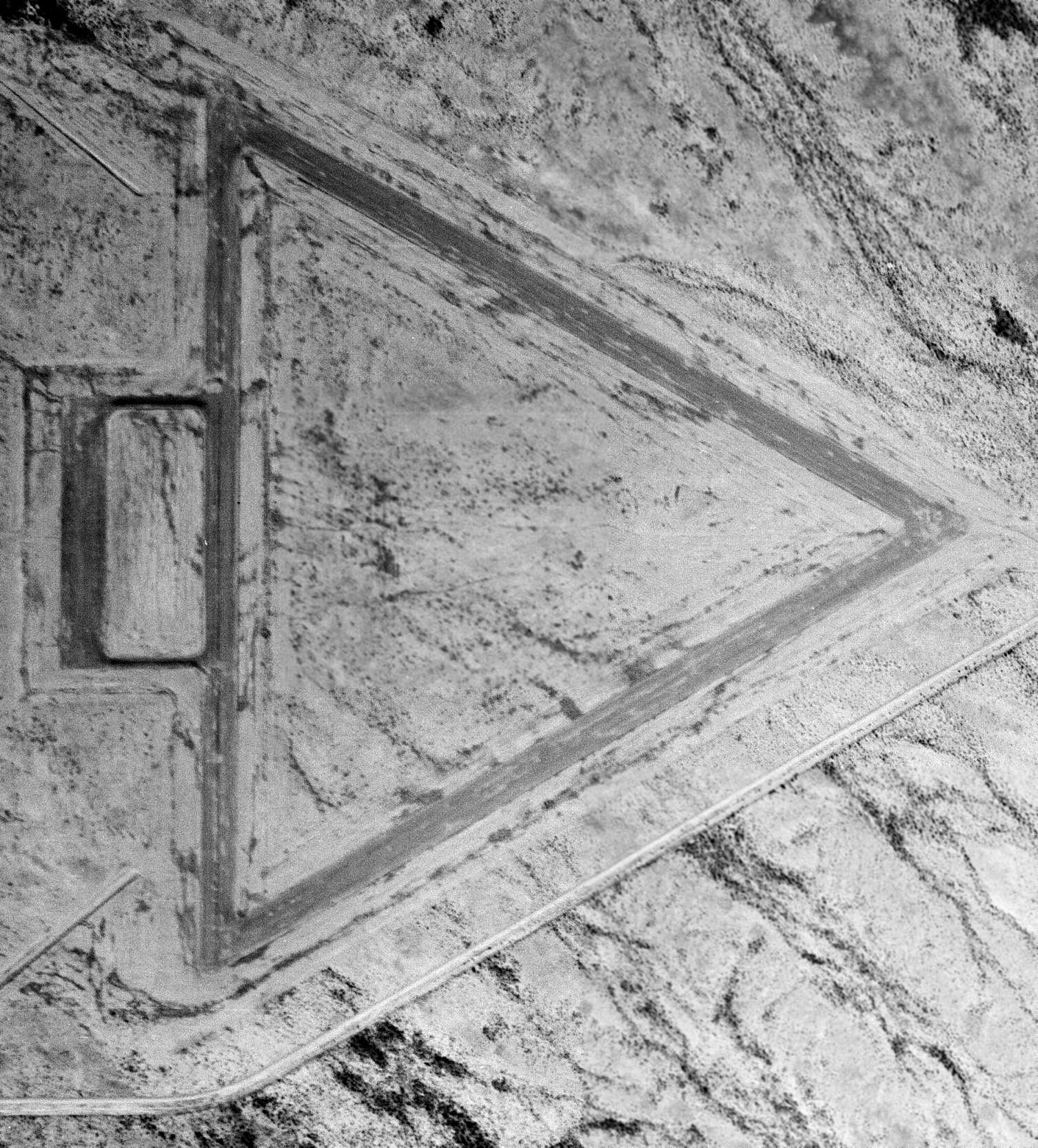
Ajo AAF Aux #2 / Williams AF Aux #2 / Luke Air Force Aux #8, Gila Bend, AZ
32.607, -112.877 (Southwest of Gila Bend AF Aux, AZ)
A 6/23/43 aerial view looking north at “Ajo AAF Auxiliary (Luke Landing Field #2)”
from the 1945 AAF Airfield Directory (courtesy of Scott Murdock).
This field is one of a string of WW2 AAF training airfields along Rt.85 between Gila Bend & Ajo.
It was built during WW2 as one of a large number of satellite airfields for Ajo AAF & Gila Bend AAF.
Ajo Aux AAF #2 was not yet depicted on the February 1943 Phoenix Sectional Chart.
The earliest depiction which has been located of this field
was a 6/23/43 aerial view looking north from the 1945 AAF Airfield Directory (courtesy of Scott Murdock).
It depicted “Ajo AAF Auxiliary (Luke Landing Field #2)” as having 3 paved runways with a paved ramp on the northwest side.
The earliest aeronautical chart depiction which has been located of Ajo Aux AAF #2 was on the March 1944 Phoenix Sectional Chart.
It depicted “No 2” as an auxiliary airfield.
The 1945 AAF Airfield Directory (courtesy of Scott Murdock) described “Ajo AAF Auxiliary (Luke Landing Field #2)”
as a 600 acre rectangular property having 3 bituminous 3,650' runways.
The field was said to not have any hangars,
to be owned by the U.S. Government, and operated by the Army Air Forces.
This field was listed as Ajo Aux AAF #2 in a directory of AZ Airports
in the 5/47 issue of Arizona Highways (courtesy of George Miller),
which described the longest runway as 3,700', and being unattended.
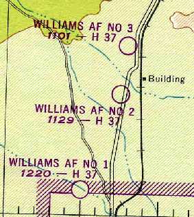
The 1949 Phoenix Sectional Chart (courtesy of Chris Kennedy) depicted "Williams AF Aux #2" as having a 3,700' paved runway.
It was still depicted as an active Air Force Field, "Williams AF #2" on the 1956 Phoenix Sectional Chart (courtesy of John Voss).
The 1958 USGS topo map depicted the 3 runways & ramp, labeled simply as "Airfield".
It is depicted as "Luke AF #8" on the 1969 USGS topo map.
This airfield apparently was closed at some point between 1956-71,
as it was labeled closed on the August 1971 USAF Tactical Pilotage Chart (courtesy of Chris Kennedy).
The 1981 USGS topo map still depicted the 3 runways, but labeled them simply as “Landing Field”.
Strangely, the 1986 USGS topo map did not depict the airfield at all, even though the 3 runways were still quite intact,
and the same topo map depicted some of the other nearby abandoned auxiliary airfields.
As seen in the 1996 USGS aerial photo, the remains of three 4,000' runways still existed.
A 10/12/13 aerial view showed Ajo Aux AAF #2 remained in the same condition.
____________________________________________________
Ajo AAF Auxiliary #1 / Williams AF Auxiliary #1 / Luke Air Force Aux #7 SW, Gila Bend, AZ
32.53, -112.935 (Southwest of Gila Bend AF Aux, AZ)
A 6/23/43 aerial view looking east at “Ajo AAF Auxiliary (Luke Landing Field #1)”
from the 1945 AAF Airfield Directory (courtesy of Scott Murdock).
This field is one of a string of WW2 AAF training airfields along Rt.85 between Gila Bend & Ajo.
It was built during WW2 as one of a large number of satellite airfields for Ajo AAF & Gila Bend AAF.
The earliest depiction which has been located of this field
was a 6/23/43 aerial view looking north from the 1945 AAF Airfield Directory (courtesy of Scott Murdock).
It depicted “Ajo AAF Auxiliary (Luke Landing Field #1)” as having 3 paved runways with a paved ramp on the west side.
The 1945 AAF Airfield Directory (courtesy of Scott Murdock) described “Ajo AAF Auxiliary (Luke Landing Field #1)”
as a 600 acre triangular property having 3 bituminous 3,650' runways.
The field was said to not have any hangars,
to be owned by the U.S. Government, and operated by the Army Air Forces.
This field was listed as Luke Aux AAF #7 in a directory of AZ Airports
in the 5/47 issue of Arizona Highways (courtesy of George Miller),
which described the field as being unattended, and the longest runway as 4,000'.
An 11/24/47 USGS aerial view depicted Luke AAF Auxiliary #7 as having 3 asphalt runways, with an asphalt ramp on the west side.
The field appeared abandoned, with no sign of recent use.
It was still depicted as an active Air Force Field, "Williams AF #1"
on the 1956 Phoenix Sectional Chart (courtesy of John Voss).
The 1958 USGS topo map depicted the 3 runways & ramp, labeled simply as "Airfield".
“Luke AF #7”, as depicted on the 1969 USGS topo map.
This airfield apparently was closed at some point between 1956-71,
as it was labeled closed on the August 1971 USAF Tactical Pilotage Chart (courtesy of Chris Kennedy).
The 1981 USGS topo map still depicted the 3 runways, but labeled them simply as “Landing Field”.
Strangely, the 1986 USGS topo map did not depict the airfield at all, even though the 3 runways were still quite intact,
and the same topo map depicted some of the other nearby abandoned auxiliary airfields.
As seen in the 1996 USGS aerial photo, the remains of three 4,000' runways still existed.
A 10/12/13 aerial view showed Ajo Aux AAF #1 remained in the same condition.
The site of Ajo Aux AAF #1 is located three miles west of Route 85, 11 miles north-northwest of Ajo, AZ.
____________________________________________________
Since this site was first put on the web in 1999, its popularity has grown tremendously.
If the total quantity of material on this site is to continue to grow,
it will require ever-increasing funding to pay its expenses.
Therefore, I request financial contributions from site visitors,
to help defray the increasing costs of the site
and ensure that it continues to be available & to grow.
What would you pay for a good aviation magazine, or a good aviation book?
Please consider a donation of an equivalent amount, at the least.
This site is not supported by commercial advertising –
it is purely supported by donations.
If you enjoy the site, and would like to make a financial contribution,
you
may use a credit card via
![]() :
:
Please consider checking the box to make a monthly donatation.
For a mailing address to send a check, please contact me at: paulandterryfreeman@gmail.com
If you enjoy this web site, please support it with a financial contribution.
This site covers airfields in all 50 states.