Abandoned & Little-Known Airfields:
Southeastern Alabama
© 2002, © 2022 by Paul Freeman. Revised 10/21/22.
This site covers airfields in all 50 states: Click here for the site's main menu.
____________________________________________________
Please consider a financial contribution to support the continued growth & operation of this site.
Brundidge Municipal Airport (added 3/18/20) - Dekker Landing Field (revised 8/21/21) - Dothan Municipal / Napier Aux AAF #2 (revised 3/8/20)
Enterprise Airport (revised 5/17/22) - Geneva Airport (original location) / Morris Field (added 12/12/21) - Phenix City Airport (revised 2/22/20)
Troy Airport (original location) (added 8/20/21) - Wheelless Airport (revised 10/21/22)
____________________________________________________
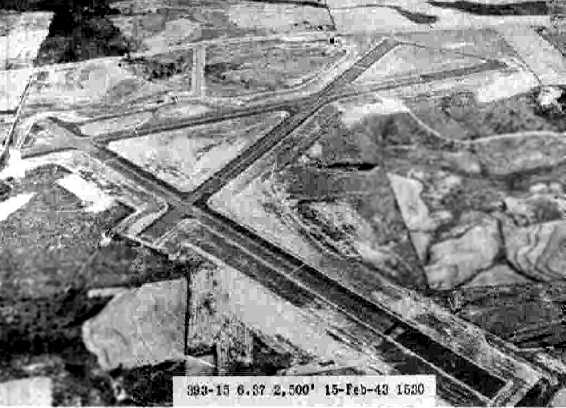
Geneva Airport (original location) / Morris Field, Geneva, AL
31.053, -85.904 (Northeast of Pensacola, FL)
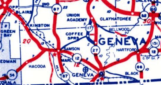
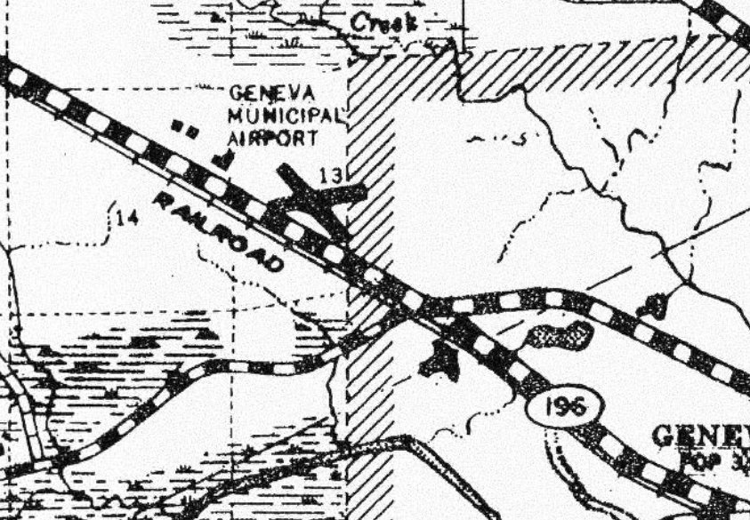
Geneva Airport, as depicted on a 1948 County Highway Map (courtesy of Rob Grant).
The original airport for the town of Geneva was located northwest of the town.
Rob Grant observed, Geneva Airport was “Undoubtedly one of many little airports which sprung up shortly after the end of WWII offering flight training under the GI Bill.”
The date of construction of Geneva Airport has not been determined.
According to Rob Grant, Geneva Flying Service, Inc. was formed on 9/6/46 by Fred, Flynn, Terrell, and John Morris.
Their airport was also known as Morris Field.
The earliest depiction which has been located of Geneva Airport was on the February 1947 Mobile Sectional Chart (according to Rob Grant).
The 9/15/1947 Directory of CAA Schools described Geneva Flying Service, Inc. as offering primary, commercial, and flight instructor schools.
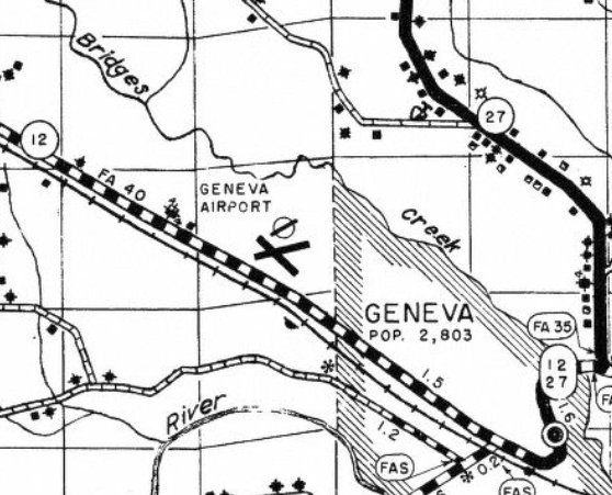
A 1950 County Highway Map (courtesy of Rob Grant) depicted Geneva Airport as having 2 runways.
The February 1950 Mobile Sectional Chart Aerodrome table described Geneva Airport as a commercial field having 2 runways, with the longest being 2,300'.
According to Rob Grant, Geneva Flying Service, Inc. was dissolved on 3/31/51.
The airport apparently reverted back to farming / grazing when the airport was closed.
The last aeronautical chart depiction which has been located of Geneva Airport was on the February 1952 Mobile Sectional Chart (according to Rob Grant).
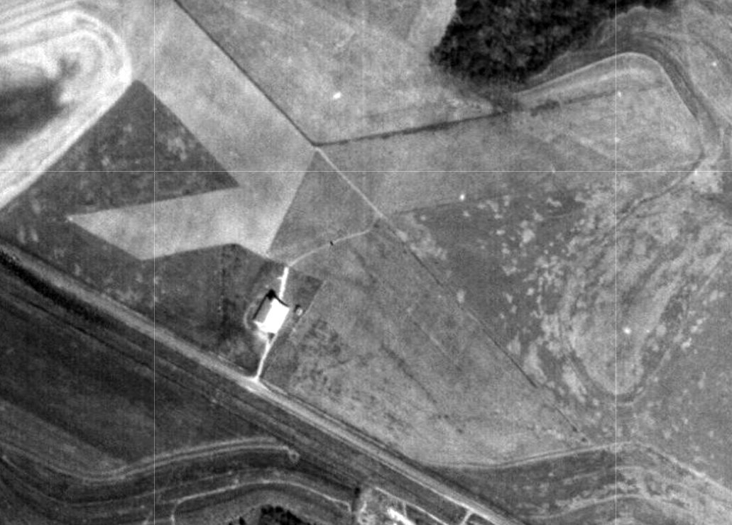
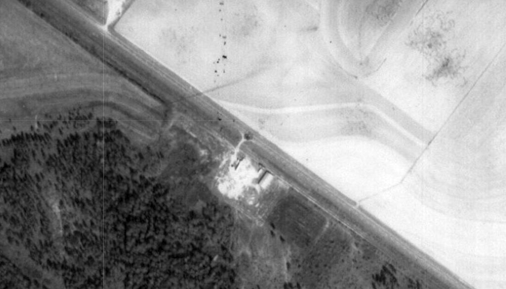
The earliest photo which has been located of Geneva Airport was a 1952 aerial view (courtesy of Rob Grant), evidently taken shortly after the airport's closure.
It depicted Geneva Airport as having 2 unpaved runways in an X-shape, with a hangar on the south side.
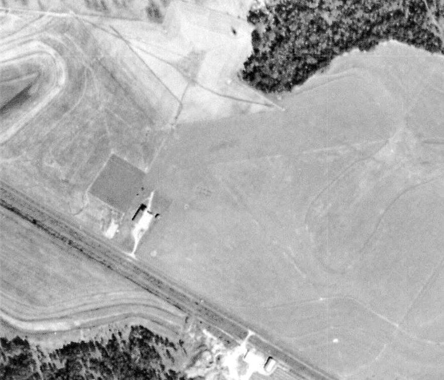
A 1956 aerial view (courtesy of Rob Grant) showed the hangar & runways of Geneva Airport remained intact.
A 1961 aerial view (courtesy of Rob Grant) showed the hangar & runways of Geneva Airport had been removed at some point between 1956-61.
Rob Grant reported, “In the early 1960s a new Geneva Airport was built just north of town, and it still serves the area today.”
A 1962 County Highway Map (courtesy of Rob Grant) still depicted Geneva Airport, even though it had been closed for over a decade by that point.
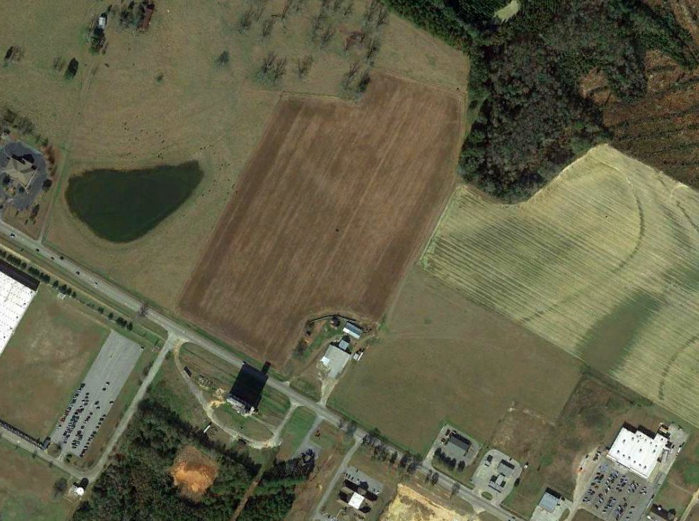
A 2019 aerial view showed no trace remained of the original Geneva Airport.
Thanks to Rob Grant for pointing out this airfield.
____________________________________________________
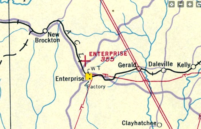
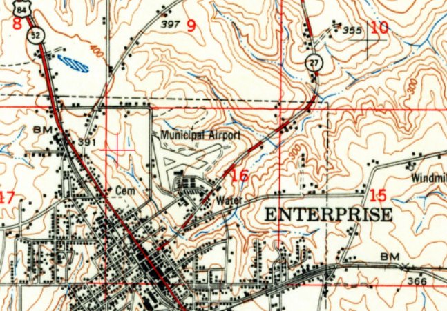
Enterprise Airport (original location), Enterprise, AL
31.324, -85.852 (Southeast of Montgomery, AL)
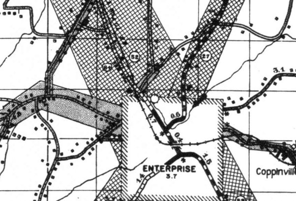
Enterprise Airport, as depicted on a 1938 Coffee County Highway Map (courtesy of Rob Grant).
The original airport for the town of Enterprise was located adjacent to the north side of the town.
According to Andrew Laverdiere, Enterprise Airport “was constructed in the 1933/34 period by the Federal Civil Works Administration as part of their state-wide airport construction project.”
The earliest depiction which has been located of Enterprise Airport was a 1938 Coffee County Highway Map (courtesy of Rob Grant).
The earliest aeronautical chart depiction which has been located of Enterprise Airport was on the July 1940 Mobile Sectional Chart (courtesy of Rob Grant).
It depicted Enterprise Airport as an auxiliary airfield.
A 1941 WPA map (courtesy of Andrew Laverdiere) depicted Enterprise Airport as a property outline on the northeast side of town.
The 1947 Directory of CAA Schools (according to Rob Grant) described the Enterprise Flying Service as offering primary & flight instructor training.
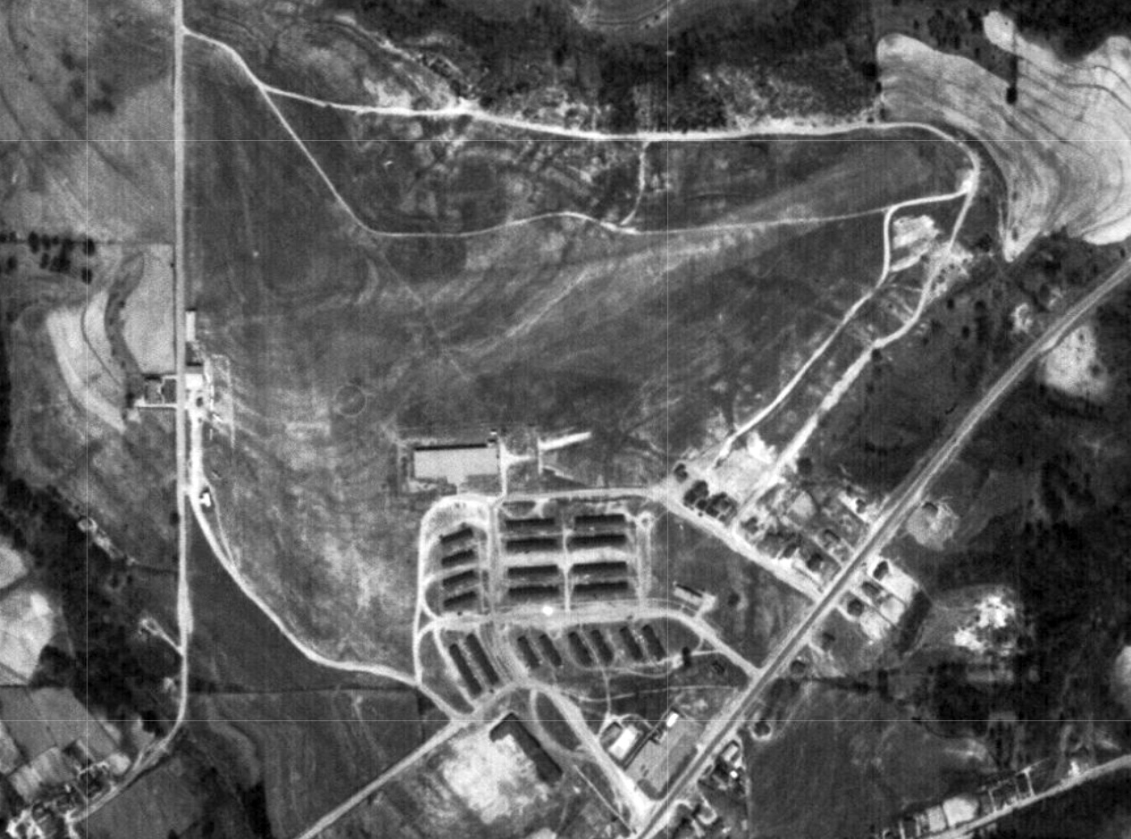
The earliest photo which has been located of Enterprise Airport was a 1948 aerial view (courtesy of Rob Grant).
It depicted Enterprise Airport as an irregularly-shaped property outline within which were 3 unpaved runways.
A few small buildings & at least 4 light single-engine planes were visible on the west side.
The 1950 Coffee County Highway Map (courtesy of Rob Grant) depicted Enterprise Airport as having 3 runways.
The earliest topo map depiction which has been located of Enterprise Airport was on the 1950 USGS topo map (courtesy of Rob Grant).
It depicted Enterprise “Municipal Airport” as having 3 runways, with a few small buildings along the west & south sides.
The Jan 1950 Airdrome Directory (according to Rob Grant) described Enterprise Municipal as a commercial/municipal airport having 3 runways, with the longest being 2,300',
and offering fuel & major repairs.
The last aeronautical chart depiction which has been located of the original location of Enterprise Airport was on the August 1951 Mobile Sectional Chart (courtesy of Rob Grant).
It depicted Enterprise Airport as a commercial/municipal airport having a 2,300' unpaved runway.
The original location of Enterprise Airport was evidently closed at some point between 1951-52,
as it was no longer depicted on the August 1952 Mobile Sectional Chart.
It would eventually be replaced by a larger Enterprise Airport located to the southwest of the town.
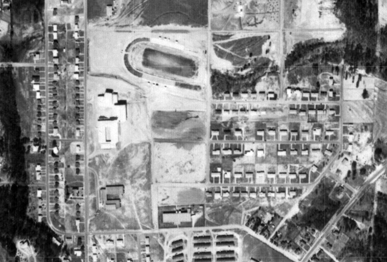
A 1957 aerial view (courtesy of Rob Grant) showed the site of the original Enterprise Airport being redeveloped into a school.
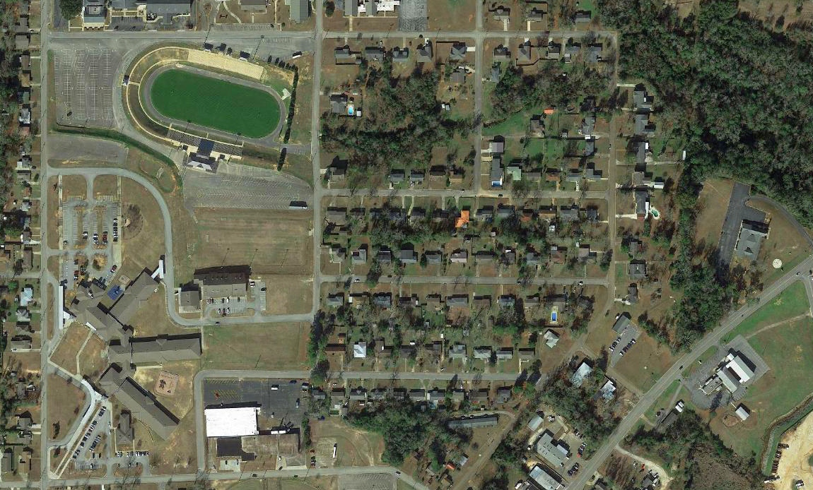
A 2019 aerial view showed Hillcrest Elementary School located on the southwestern portion of the original Enterprise Airport site, and houses over the eastern portion.
A building along the southern edge dated was also seen in the 1948 aerial view, but it was not evident whether this building was related to the airport.
A clue to the previous use of the property may be found looking at the name of the road which runs along the southern edge of the original Enterprise Airport site: Airport Road.
Thanks to Rob Grant for pointing out this airfield.
____________________________________________________
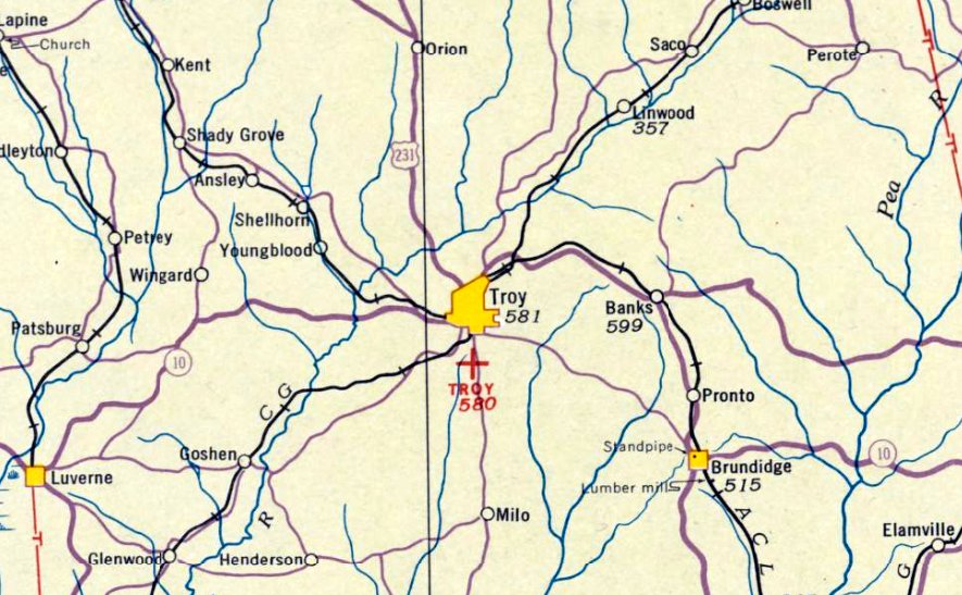
Troy Airport (original location), Troy, AL
31.777, -85.967 (Southeast of Montgomery, AL)
Troy Airport, as depicted on the August 1935 Birmingham Sectional Chart (courtesy of Rob Grant).
The date of construction of Troy Airport has not been determined.
The earliest depiction which has been located of Troy Airport was on the August 1935 Birmingham Sectional Chart (courtesy of Rob Grant),
which depicted Troy as an auxiliary airfield.
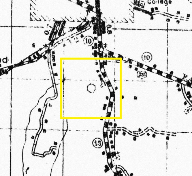
Troy Airport, as depicted on a 1937 Pike County Highway Map (courtesy of Rob Grant).
A 1938 airport directory (according to Rob Grant) described Troy Airport as an auxiliary airfield located 2 miles south of the center of the city.
It was said to consist of a rectangular clay field within which were 2 runways measuring 2,000' east/west & 1,700; northeast/southwest.
Rob Grant reported, “Shortly after the end of WW2, the Troy AAF Auxiliary Field [northwest of the town] became the current-day Troy Municipal Airport, and the original airport site was closed & sold.”
The Troy Country Club website reported, “On 3/21/46 corporate papers were filed at the Pike County Court House forming Troy Country Club.
After WW2, several of Troy's solid leaders of the century decided to build something that would endure the test of time.”
Thus the original Troy Airport property was redeveloped as a golf course.
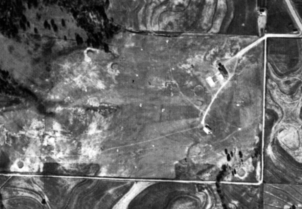
A 1948 aerial photo (courtesy of Rob Grant) showed the site of the original Troy Airport in the course of being redeveloped as a golf course.
The concrete segmented circle still remained on the east side of the site.
It has not been determined if any of the nearby buildings dated from the property's airport days.
The original Troy Airport property was depicted as a golf course on the 1950 Pike County Highway Map (courtesy of Rob Grant).
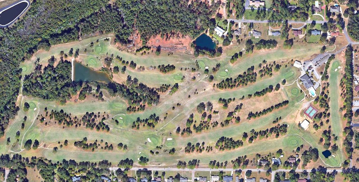
A 2016 aerial view of the site of the original Troy Airport shows the Troy Country Club covering the site, but the original property outline remains recognizable.
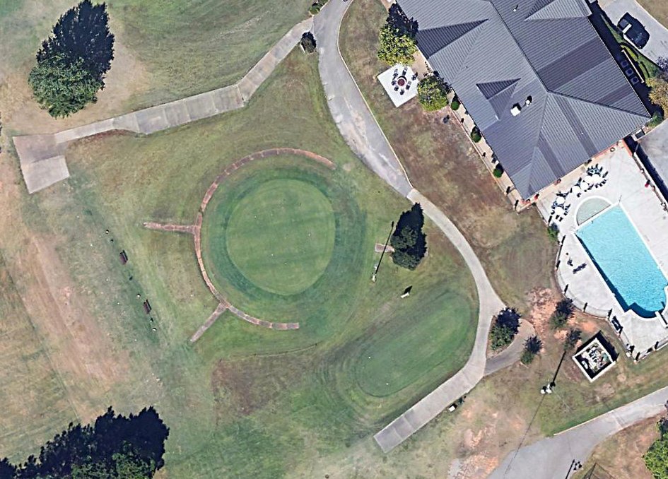
Amazingly, the 2016 aerial photo shows the concrete segmented circle remains mostly intact on the east side of the site of the original Troy Airport, 70 years after the airport's closure.
Thanks to Rob Grant for pointing out this airfield.
____________________________________________________
Brundidge Municipal Airport (60A), Brundidge, AL
31.732, -85.805 (Southeast of Montgomery, AL)
Brundidge Municipal Airport, as depicted on a 1962 aerial photo (courtesy of Rob Grant).
Brundidge Municipal Airport was evidently established at some point between 1961-62,
as it was not yet depicted on the February 1961 Mobile Sectional Chart.
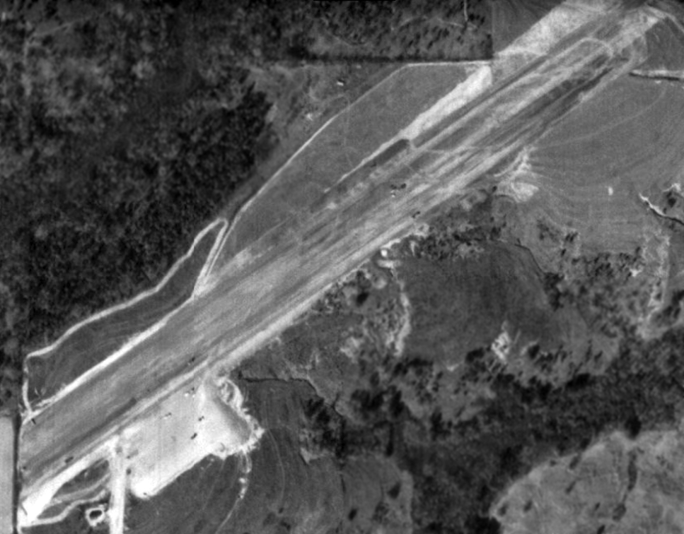
The earliest depiction which has been located of Brundidge Municipal Airport was on a 1962 aerial photo (courtesy of Rob Grant).
It appeared to depict the airport under construction, with a single northeast/southwest runway being graded.
The earliest aeronautical chart depiction which has been located of Brundidge Municipal Airport was on the April 1965 Brundidge Municipal Airport.
It depicted Brundidge as having a 3,000' paved runway.
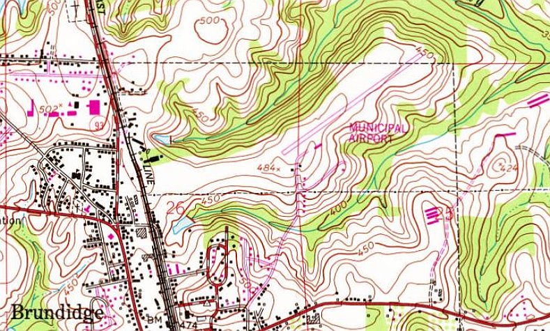
The 1981 USGS topo map depicted Brundidge Municipal Airport as having a paved northeast/southwest runway, with one small building on the south side.
The only photo which has been located showing an aircraft at Brundidge Municipal Airport was a 1992 USGS aerial view.
It depicted Brundidge as having a single paved northeast/southwest runway, with a ramp, one small building, and 1 light single-engine aircraft on the south side.
According to its FAA dtaa, Brundidge Municipal Airport consisted of a 40 acre property, having one 3,000' asphalt Runway 5/23.
For the year ending 10/13/99, Brundidge Municipal Airport, had a total of 7 takeoffs or landings per day.
Brundidge Municipal Airport may have been closed (for reasons unknown) at some point between 1999-2006,
as a 2006 aerial view showed the runway had no markings, no aircraft were visible on the field,
and the property appeared to be used for non-aviation storage.
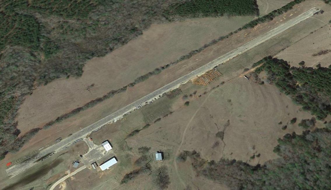
A 2015 aerial view looking north showed the runway & hangars of Brundidge Municipal Airport remained intact thought deteriorated.
As of 2020, Brundidge Municipal Airport was depicted as an abandoned airfield, as was listed as “Closed indefinitely” with the FAA.
Thanks to Rob Grant for pointing out this airfield.
____________________________________________________
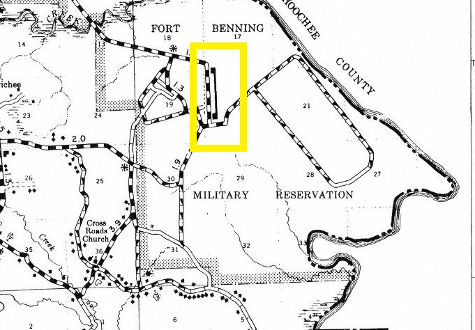
Dekker Landing Field, Fort Mitchell, AL
32.286, -84.947 (East of Montgomery, AL)
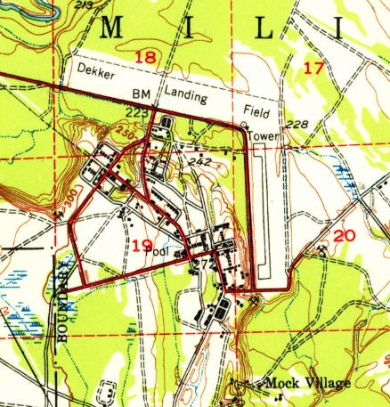
Dekker Landing Field, as depicted on the 1947 USGS topo map.
The date of construction (or specific purpose) has not been determined of this small airfield on the southeast side of the Fort Benning installation.
It was not depicted on the 1945 USGS topo map
or the April 1945 Birmingham Sectional Chart (nor on later Sectional charts through 1968).
The earliest depiction which has been located of Dekker Landing Field was on the 1947 USGS topo map.
It depicted a paved north/south runway, and the outline of a possible crosswind unpaved runway to the northwest.
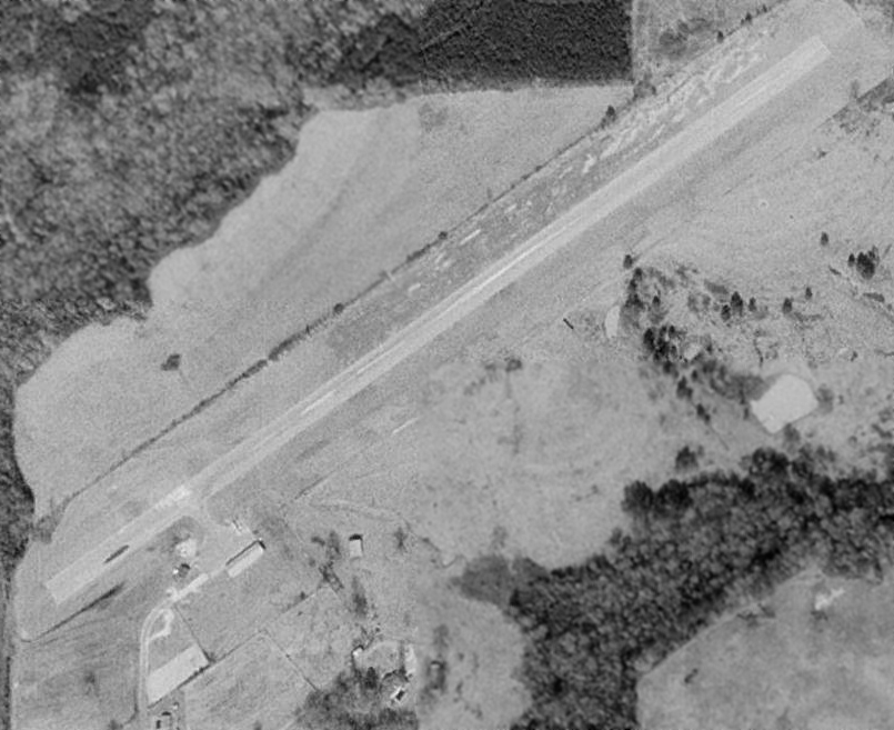
The earliest photo which has been located of the Dekker Landing Field was a 1949 aerial view (courtesy of Rob Grant).
It depicted Dekker as having a single paved north/south runway, along with an unpaved crosswind runway.
A 1954 Russell County Highway Map (courtesy of Rob Grant) depicted Dekker Landing Field as having a single paved north/south runway.
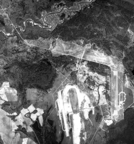
A 1962 aerial photo (courtesy of Rob Grant) appeared to show Dekker landing field as no longer being used for aviation, with the unpaved northwest/southeast runway being deteriorated,
and an oval track having been constructed at some point between 1953-62 adjacent to the southeast side of the paved north/south runway.
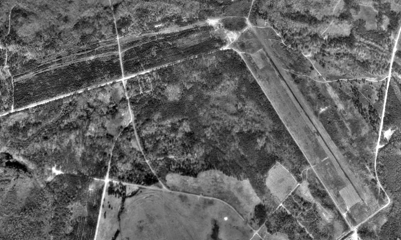
A 1993 USGS aerial view looking northeast depicted Dekker Landing Field as having a single paved north/south runway, along with an unpaved crosswind runway.
There was no sign of any recent aviation usage.
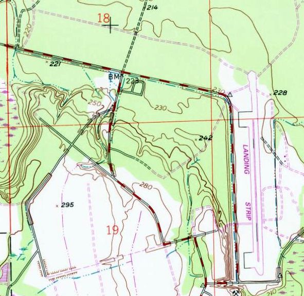
The 1993 USGS topo map still depicted the paved north/south runway, but labeled it simply as “Landing strip”.
The crosswind runway was no longer depicted.
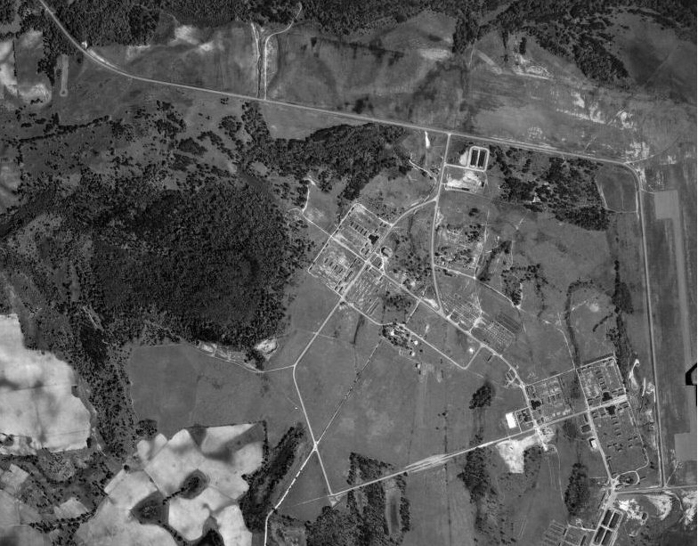
A 2016 aerial view looking northeast at Dekker Landing Field showed the paved north/south runway remained intact,
along with the outline of the unpaved crosswind runway.
There was no sign of any recent aviation usage.
The site of Dekker Landing Field is located northeast of the terminus of 101st Airborne Division Road.
Thanks to Kevin Walsh for pointing out this airfield.
____________________________________________________
Phenix City Airport, Phenix City, AL
32.5, -85.01 (East of Montgomery, AL)
Phenix City Airport, as depicted on the October 1948 Mobile Sectional Chart.
This small general aviation airport was evidently established at some point between 1947-48,
as it was not yet depicted on the October 1947 Mobile Sectional Chart.
The earliest depiction which has been located of Phenix City Airport was on the October 1948 Mobile Sectional Chart.
It depicted Phenix City as an auxiliary airfield.
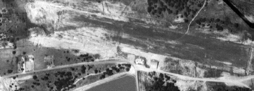
The earliest photo which has been located of Phenix City Airport was a 1949 aerial view (courtesy of Rob Grant).
It depicted Phenix City as having a single unpaved northwest/southeast runway, with 2 buildings (hangars?) on the south side.
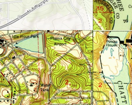
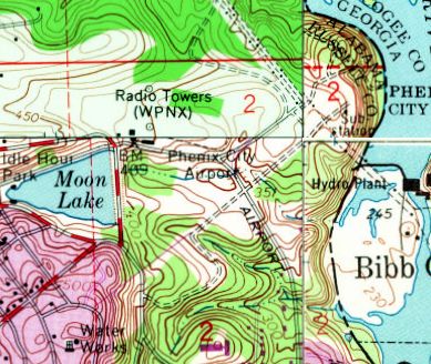
Phenix City Airport, as depicted on the 1950 USGS topo map.
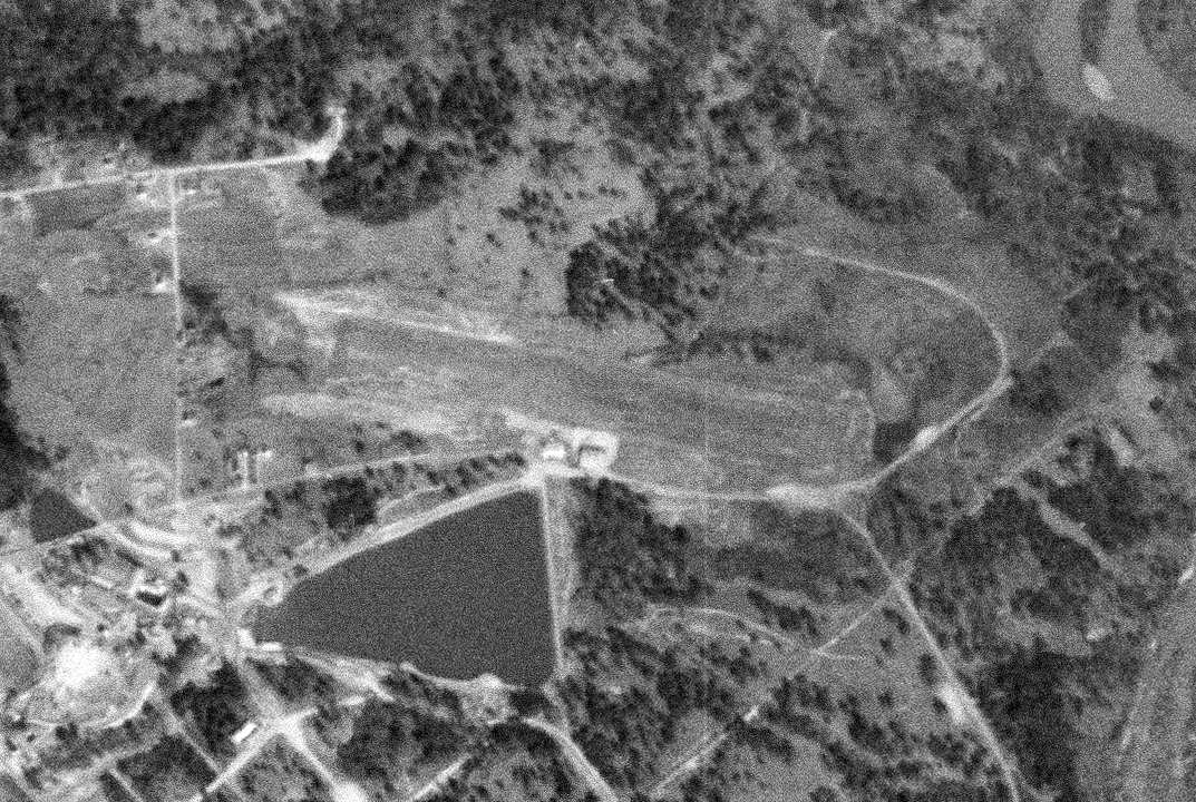
A 2/12/51 USGS aerial view depicted Phenix City as having a single unpaved northwest/southeast runway, with 2 buildings (hangars?) on the south side.
Phenix City Airport was evidently closed (for reasons unknown) at some point between 1951-62, as a 2/11/62 USGS aerial view showed that a road had been built across the runway.
Phenix City Airport was still labeled on the 1968 USGS topo map, even though it had evidently already been closed for at least 6 years by that point.
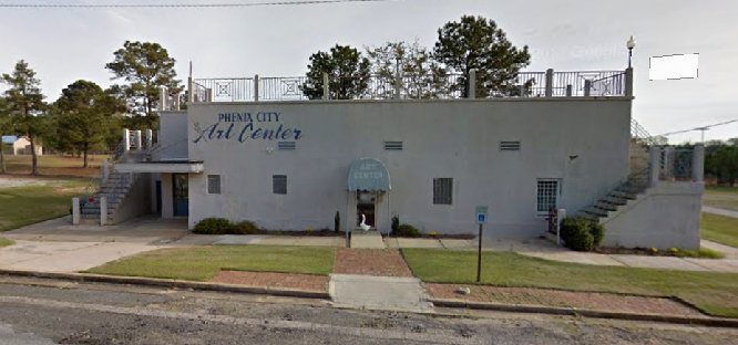
A circa 2012-2018 photo looking north at the former Phenix City Airport terminal building (courtesy of Rob Grant).
Rob Grant observed, the building is “now owned by Phenix City & used as an arts center. Note the exterior staircases leading to the roof observation area.”
A 2014 aerial view looking northwest showed the Phenix City Airport runway had been covered by tennis courts & ballfields,
but the terminal building remained along the southwest side (just below the tennis courts at top-right).
The site of Phenix City Airport is located northwest of the intersection of 5th Avenue & Airport Road, appropriately enough.
Thanks to Gary Pike for pointing out this airfield.
____________________________________________________
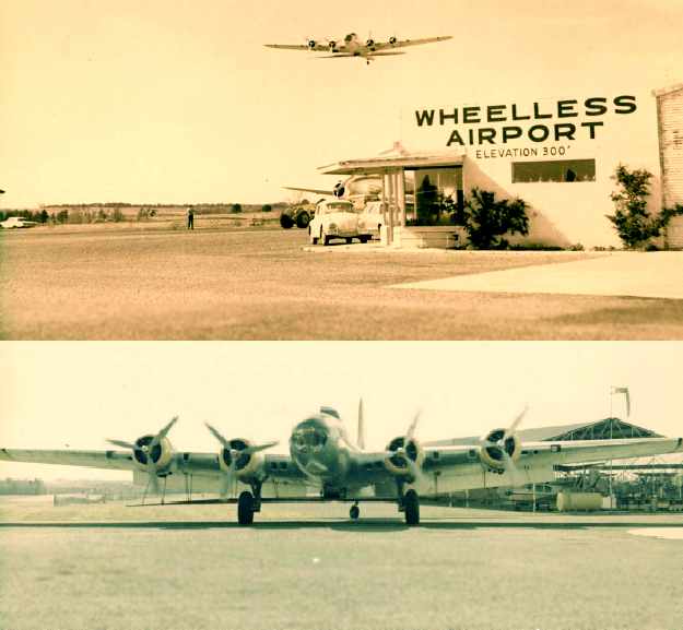
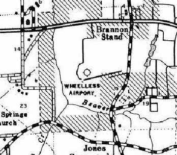
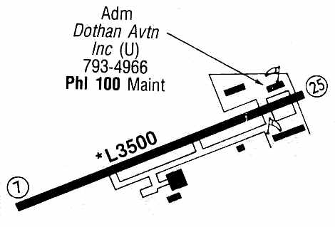
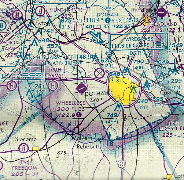
Wheelless Airport (37J), Dothan, AL
31.23, -85.49 (West of Downtown Dothan, AL)
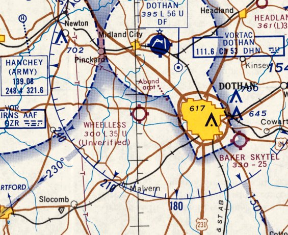
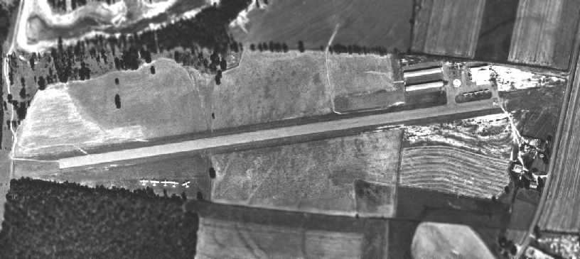
Wheelless Airport, as depicted on the February 1966 Mobile Sectional Chart.
This small general aviation airport was located only 2 miles west of the Dothan Municipal Airport.
According to Virgil Fenn, the growth of the City of Dothan up to the edge of the original Dothan Municipal Airport
“was the main factor for Mr. Wheelless building his airport on his farm.”
The date of construction of Wheelless Airport has not been determined.
The earliest reference to the airport comes from Keith Brown,
who recalled, “I took my first airplane flight as a young boy somewhere around 1959-60
out of that airport when my daddy showed an agricultural pilot where our field was to be dusted.”
Wheelless Airport was not yet depicted on the February 1965 Mobile Sectional Chart.
The earliest depiction which has been located of Wheelless Airport was on the February 1966 Mobile Sectional Chart.
It depicted Wheelless Airport as having a 3,500 unpaved runway, which was “Unverified”.
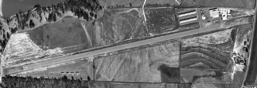
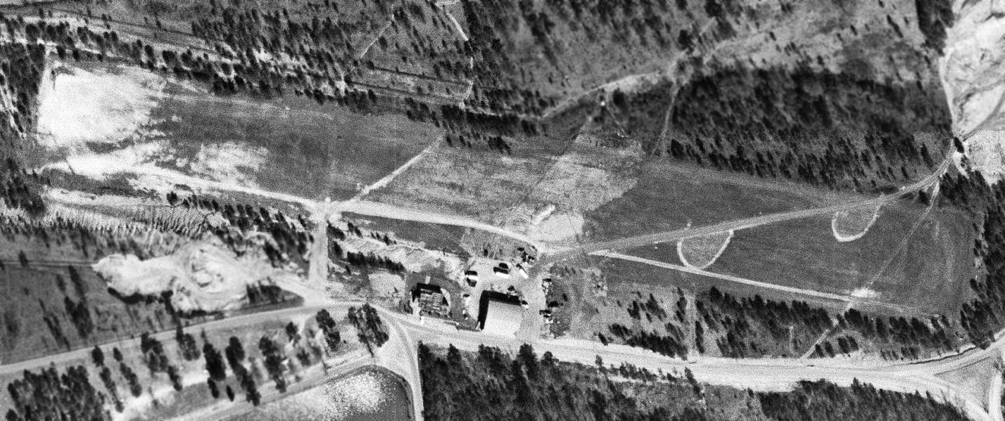
The earliest photo which has been located of Wheelless Airport was a 2/5/66 aerial photo.
It depicted Wheelless Airport as having a single paved northeast/southwest runway.
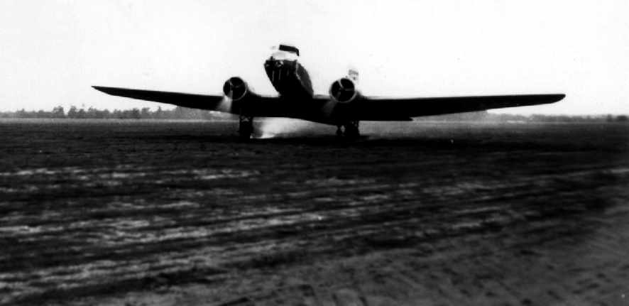
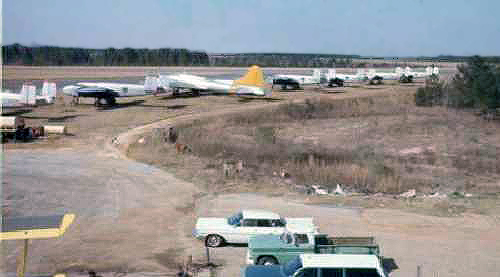
A paved ramp on the northeast side of the field also had 3 hangars, near which was parked a B-17 Flying Fortress bomber & 4 smaller aircraft.
A row of 4 B-25 Mitchell bombers was parked on the southwest side of the field.
Wheelless Airport, as depicted on a 1967 AL Highway Department map (courtesy of Chris Kennedy).
Tom Stoy recalled, “I started flying in 1964 & got my CPL & ATP at Dothan Municipal.
I later ended up at Wheeles, 'To gain experience', thanks to Clide Lovall, my examiner at the time.
It took several approaches to get a job from Mr. Wheelless
as he considered me overqualified for any job in his company with a college degree.
I finally made it & enjoyed every single day.
I worked there as mechanic, hangar floor & airplane cleaner etc,
finally did engineering drawings & got my first crop spraying experiences, ferrying spray planes
and as co pilot on the PV-2 & B-17 during the fire ant program in Longview TX & Savanna GA.
Field spotting with farmers was one of my favorites! Great memories are related to the good old Wheelless Airport.”
A 1968 Soil Conservation Service aerial photo of Wheelless Airport (courtesy of Thomas Kallsen of the University of AL Map Library).
The photo depicted Wheelless Airport as having a single paved runway, oriented northeast/southwest.
A paved ramp on the northeast side of the field also had 3 hangars.
A total of 5 light aircraft were visible on the ramp, and 5 larger aircraft were parked in a separate location to the southwest of the runway.
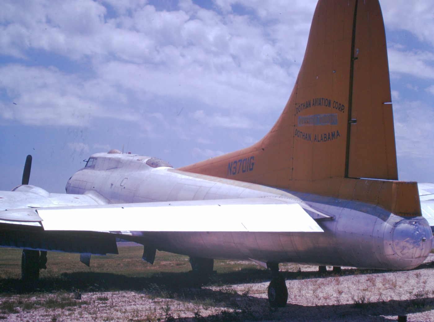
Two 1968 photos by Virgil Fenn of B-17 N5017N at Wheelless Airport.
Virgil reported in 2006, “This B-17 is presently owned by the Experimental Aviation Association.”
Virgil Fenn recalled, “I was Vice President & Chief Pilot for Dothan Aviation Corporation.
We operated 7 B-25's, 7 PV-2's, 3 B-17's, and 3 Martin 404's. We also had a fleet of Stearman, Ag-Cats, and Cub Dusters & Sprayers.”
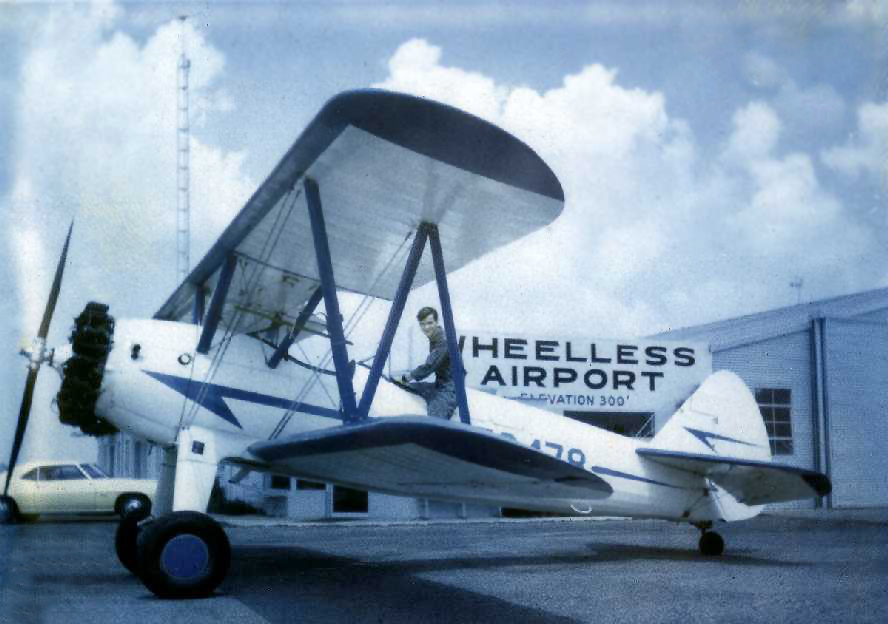
A circa late 1960s photo of Tom Stoy on a Stearman at Wheelless.
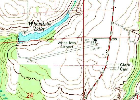
The earliest topo map depiction which has been located of Wheelless Airport was on the 1969 USGS topo map.
It depicted Wheelless as having a single northeast/southwest paved runway with 4 buildings on the northeast & southeast sides.
Tom Stoy recalled, “When I left Wheelless in late 1969 the large hangar
and the all the small buildings shown south (to the right) of the runway did not exist.
At the time we had 3 B-17s & 2 PV-2 Lockheed Lodestars, several AG-Cats,
Stearmans & B-25s used for spares only, as far as I remember.”
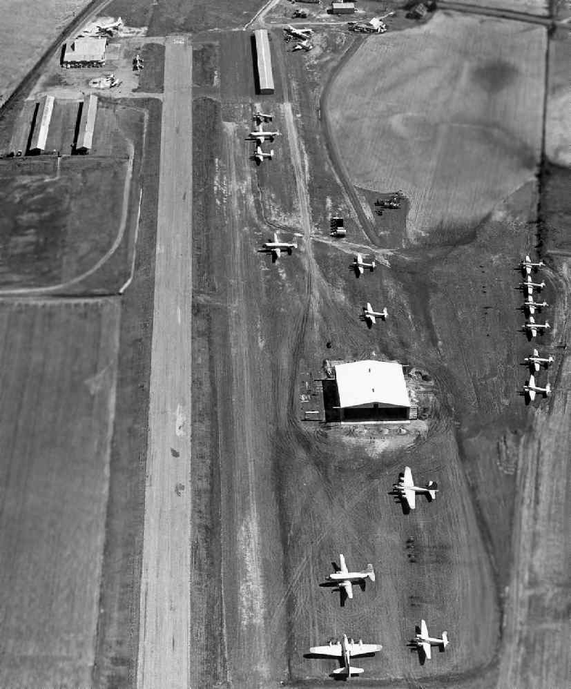
A circa 1969 (or later) aerial view looking east down Wheelless' Runway 7 (courtesy of Virgil Fenn, via Art Morris, via Tim Cotter).
Note the large number of B-17s & other large multi-engine aircraft at the field.
According to Tim, “Virgil worked with Mr. Wheelless flying B-17s & other WWII vintage airplanes spraying fire ants before the pesticides were banned.”
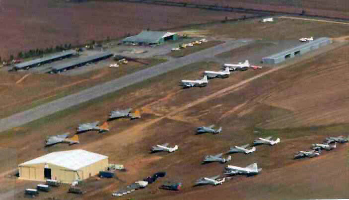
A circa 1969 (or later) aerial view looking northeast at Wheelless Airport (courtesy of Virgil Fenn, restored by Bill Grasha),
showing an amazing array of WW2-era aircraft, including 3 B-17s.
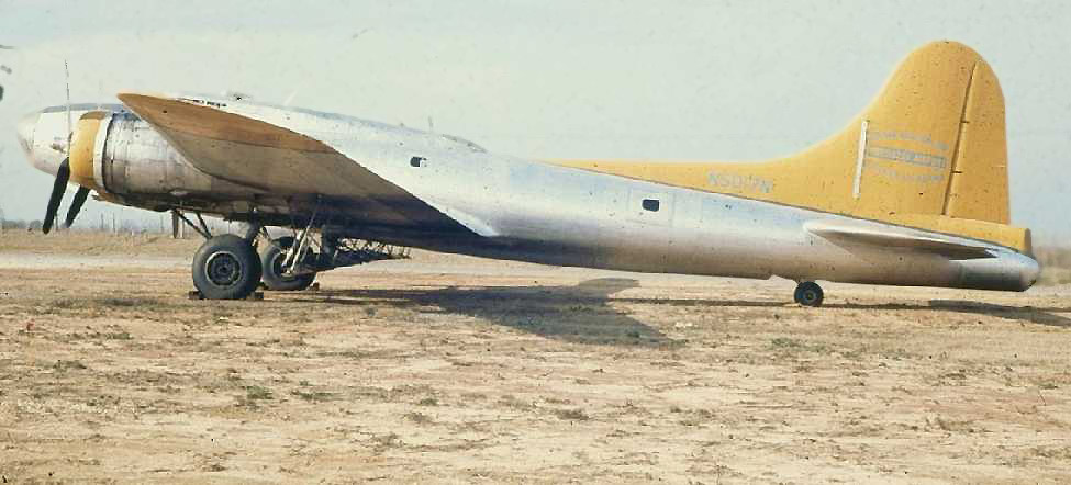
A 1969 photo by Don Millman (restored by Bill Grasha) of a 1944 Boeing B-17G Flying Fortress, N5017N, serial # 8649, most likely taken at Wheelless Airport.
Note the spray bar rigged under the wing.
According to Hugh Wheelless Jr., airport founder “Hugh Sr. died of cancer in February of 1970.”
Richard Cuber recalled, “I was stationed at Fort Rucker in 1970
and doing Project Transition at Wheelless in mid 1970.
Wheeless Aviation was the largest crop dusting company in the south at that time.
The B-25s were there at that time, they were parked because of the cost of flying them with 2600s.
They were flying 3 B-17s & 3 PV2 Harpoons for contracts on poisoning fire ants all over the South.
They also flew Agcats, Cubs and quite a few Stearmans for normal dusting & spraying.
They also did some maintenance on private aircraft.
The Wheeless family owned & operated the firm.”
A 1971-72 photo by Ken Morrison of a Boeing B-17 Flying Fortress at Wheelless Airport
Ken recalled, “The B-17 is now owed by EAA & flies as the 'Aluminum Overcast'.
My Cub N42090 was restored at Wheelless in 1971 & I based it there in a hanger until I left the Army in the spring of 1972.
Boy what an amazing airport - I could have taken a hundred photos, but at the time I thought this airport like so many others would be there forever.
There were lots of B-17s, B-25s, P2Vs and other WW2 airplanes there.
The heavy airplanes were used to spray for fire ants but after the use of DDT was banned they stopped flying them.”
A 1971-72 photo by Ken Morrison of a North American B-25 Mitchell at Wheelless Airport.
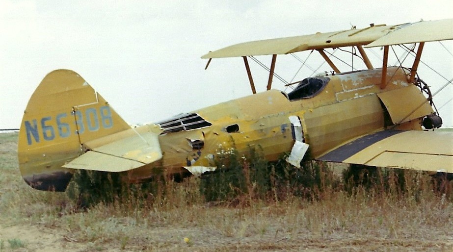
A 1971-72 photo by Ken Morrison at Wheelless Airport, of “a used-up Stearman duster.”
Gary Johnson recalled, “My father, Joe Johnson founded Air Prop Specialists around 1974.
They operated out of Wheelless Airport & I spent many summers there cleaning propellers & playing in & around the B-17s.
One day someone came in, tinkered with one for a couple of hours & flew it out.”
Keith Brown recalled, “There was a hurricane or maybe by that time a tropical depression
that came through in the late summer or fall of 1975.
I can remember going out there & seeing the B-17s & B-25s.
I met one of the pilots who flew the B-17 as mosquito sprayer over to Mississippi.
I remember the J-3s & Stearmans or Ag-Cats sitting around. It was a great little airport. I miss it dearly.”
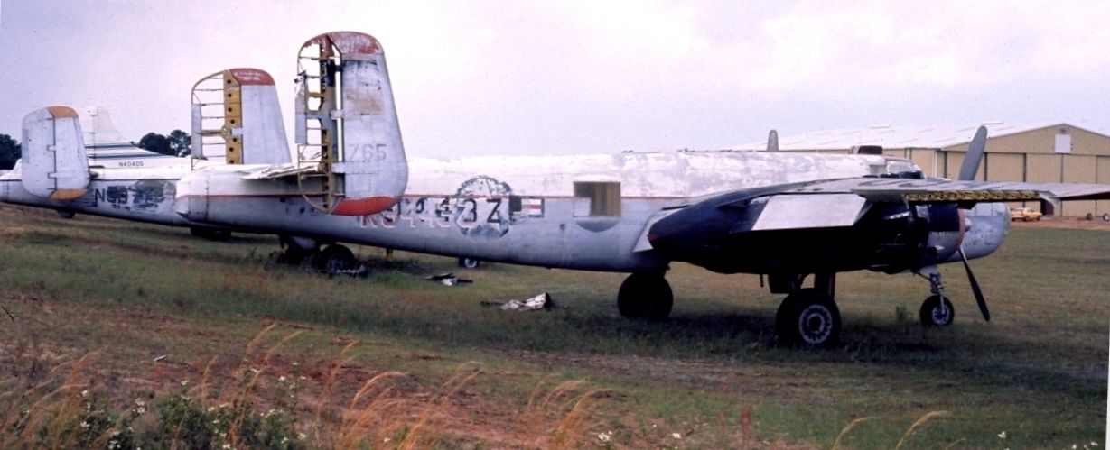
A 4/19/75 photo of a forelorn-looking North American TB-25N Mitchell N9443Z serial #44-28765 at Wheelless Airport.
The aircraft was operated as a sprayer by Dothan Aviation Corporation, and was subsequently parted out, with the nose section going to the Smithsonian.
The January 1976 New Orleans Sectional Chart (courtesy of Chris Kennedy) depicted Wheelless as having a single 3,500' paved runway.
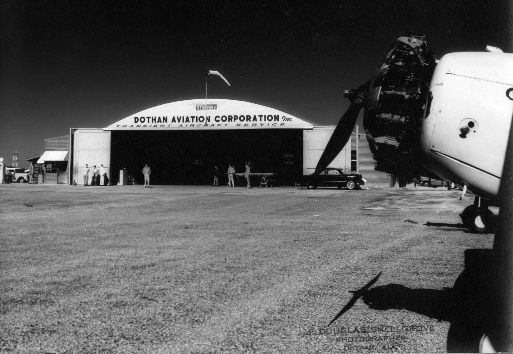
The 1976 AOPA Airport Directory (according to Chris Kennedy) listed the operator of Wheelless Airport as the Dothan Aviation Corporation.
The 1978 AL Highway Department map (courtesy of Chris Kennedy)
depicted Wheelless Airport as having a single runway, oriented northeast/southwest.
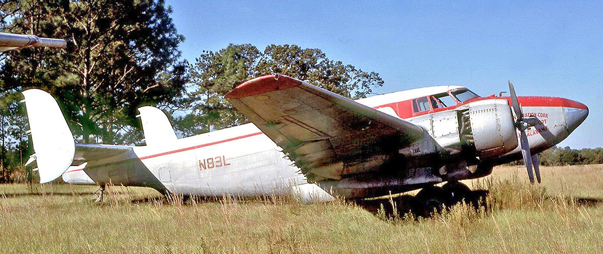
A 10/20/81 photo by Geoff Goodall of Dothan Aviation Lockheed PV-2D(AT) Harpoon N83L C/n 15-1501 at Wheelless Airport.
The 1986 Flight Guide (courtesy of Chris Kennedy) depicted Wheelless Airport as having a single 3,500' paved Runway 7/25.
Taxiways led to several hangars on the north & south side of the runway.
The office of Dothan Aviation Incorporated was in a building on the northeast corner of the field.
Tim Cotter recalled, "During the 1980s, I made a few landings at the Wheelless Airport,
plus I visited a propeller repair facility there during my A&P mechanic training."
Brian Newsome recalled "2 B-25 bombers that were at one time on the property of Wheelless Airport.
I remember going with my father & grandfather back in the early to mid-1980s & seeing them over in a wooded area.
They were not in a flyable state but still looked fairly decent."
The last aeronautical chart depiction which has been located of Wheelless Airport was on the 1990 New Orleans Sectional Chart.
It depicted Wheelless as having a 3,500' paved northeast/southwest runway.
Dean Peeples recalled, “From 1990-91 I worked on a restoration project at Wheelless Airport.
Thomas Duncan & I returned Lockheed PV-2D, serial #151501, tail # N83L, to ferry flight status in July of 1991.
We then flew with the aircraft to Pearson Field in Vancouver, WA where it was finished for the warbird show circuit.
This aircraft was owned at the time by Neil Rose of Vancouver.
N83L was the last flyable warbird to leave Wheelless (only the shell of PV-2C NC47G was left),
and it was also the first production D model in service.”
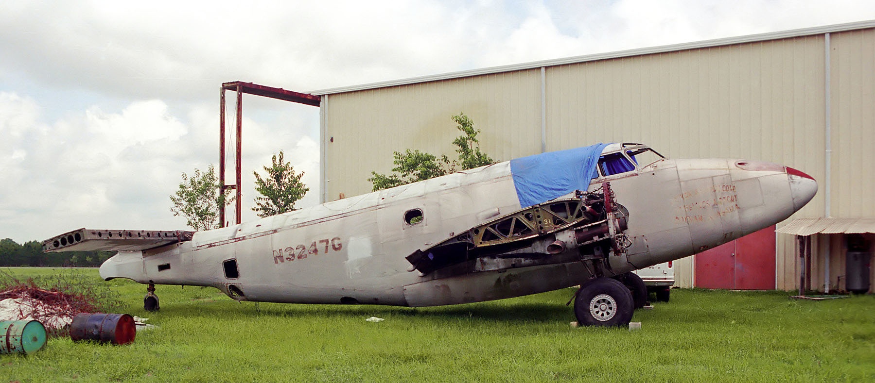
A 5/12/91 photo by Shaun Connor of Lockheed PV-2 Harpoon N3247G C/n 15-1231 at Wheelless Airport.
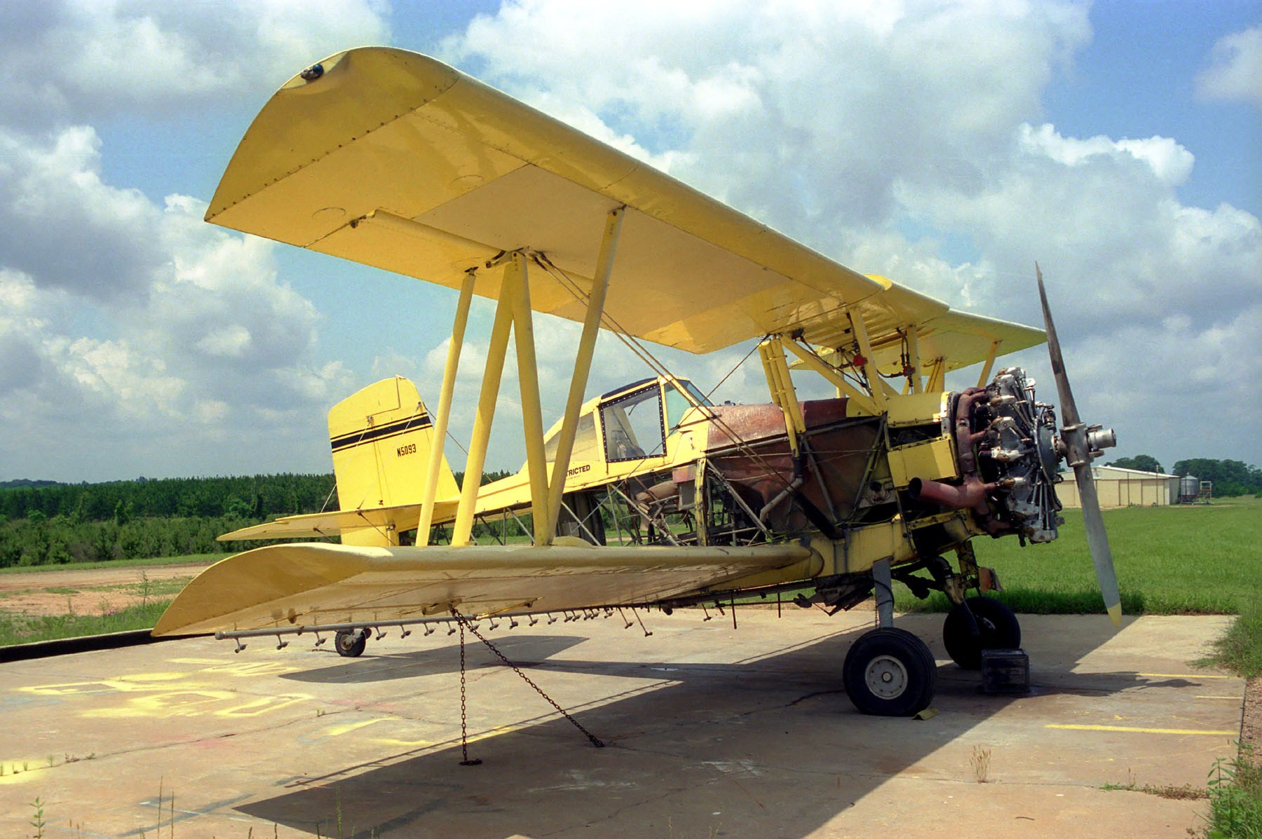
The last photo which has been located showing an aircraft at Wheelless Airport was a 5/12/91 photo by Shaun Connor of Grumman G-164A Ag-Cat N5093 C/n 1122.
Dean Peeples recalled, “I was last at Wheelless in October 1991 to crate up leftover parts for shipment to Vancouver.
This airport & aircraft in particular bear a place in my memory for the history attached to both.”
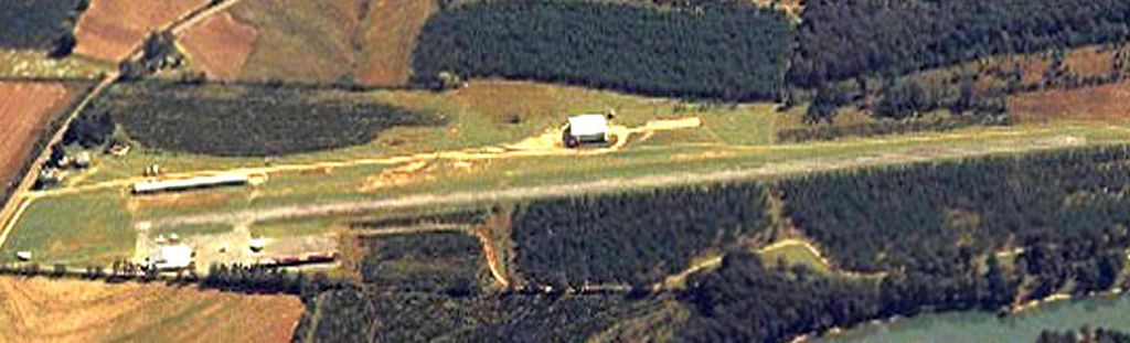
A circa early 1990s aerial view looking south (courtesy of Hugh Wheelless Jr.) “showing Wheelless Airport just before it was closed.”
Wheelless Airport was apparently closed in 1992, according to a monument which occupies the site in 2004.
However, Ron Traywick reported, "Wheelless Field was still active as a base for ultralights sometime between the 1992-96 timeframe.
I passed by it frequently during that time."
By the time of the 1998 World Aeronautical Chart, the former Wheelless Airport was depicted as an abandoned airfield.
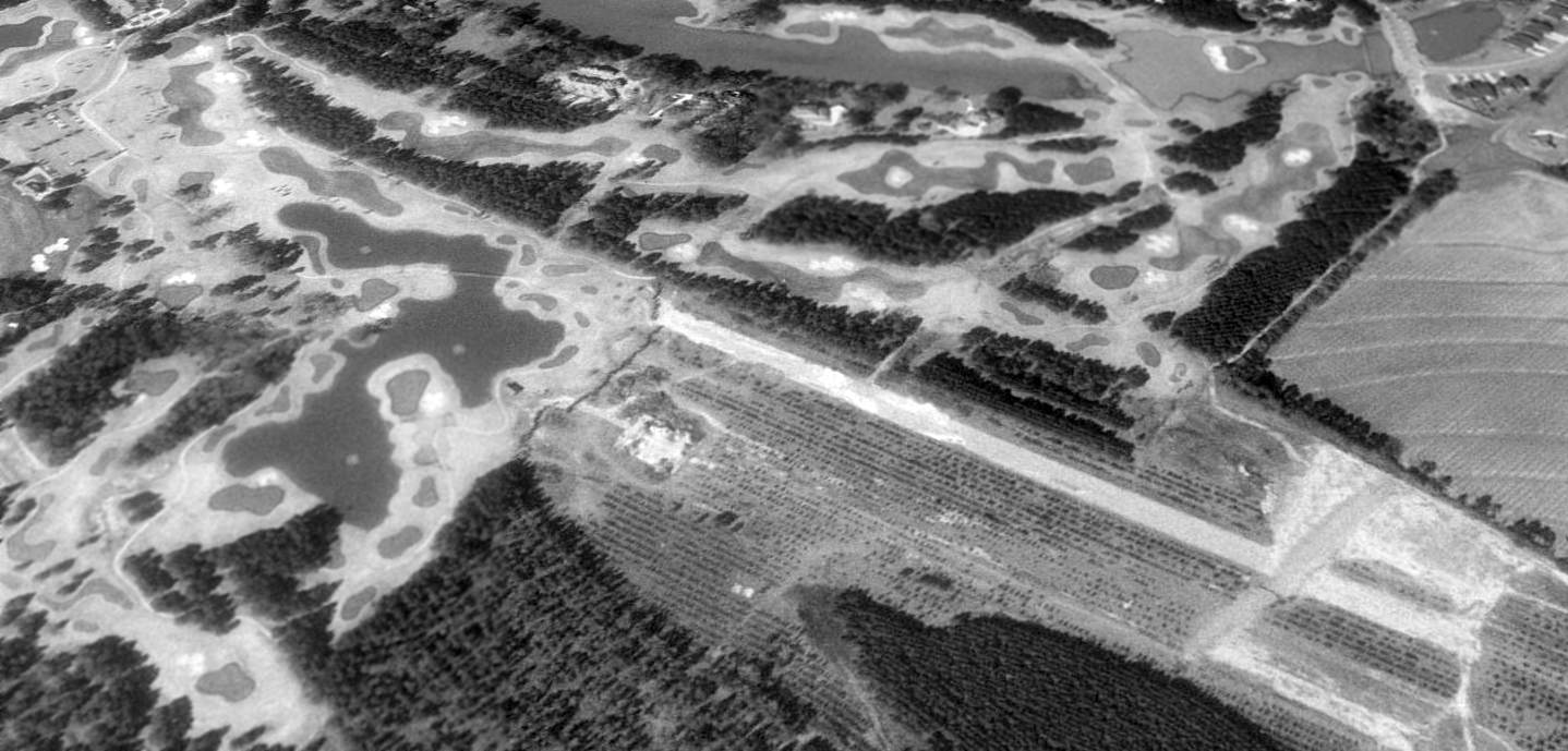
As seen in a 1998 USGS aerial view looking northwest at the site of Wheelless Airport, the probable reason for the airport's demise was apparent - the property was more "valuable" redeveloped as a golf course.
Soon to be the fate of many small airports if things don't change.
The western half of the former airport had been covered by a Robert Trent Jones golf course (according Ron Traywick),
but approximately 2,000' of the east end of the former runway pavement remained intact as of 1998.
All of the former airport buildings & hangars had been removed.
Hugh Wheelless Jr. reported, “There is now a 282 unit apartment complex just east of the old Wheelless Airport.
There is another complex on the site of the old airport of 184 units & an elementary school that has 600 students plus staff, south of the airport.
I did all the development work.”
Ron Traywick reported that the eastern portion of the former airport was covered with new apartments, "sometime around 1996-99."
A 2003 aerial photo showed that no trace of Wheelless Airport remained.
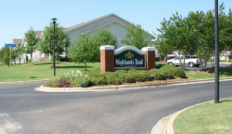
A 2004 photo by Tim Cotter of the Highlands Trail apartment complex which occupies the site of the former Wheelless Airport.
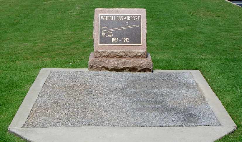
A 2004 photo by Tim Cotter of the monument at the site which commemorates the former Wheelless Airport.
Tim Cotter reported in 2004, "My fiancée is living in an apartment complex constructed on the site of Wheelless Airport.
Located there is a monument & a square yard of the original asphalt from the airport runway."
Dean Peeples reported in 2006, “Several months ago I was down in Dothan & went to see the plaque marking the grave of Wheelless Airport.
It was late in the day & I had a long drive back to Birmingham, but I had to stop & see for myself.
As I stood there, for just a moment, the rumbling idle of my Softail on the curb behind me became the sound of a PW 2800 at idle.
I caught a whiff of 115 avgas & Aeroshell 120 & felt the wash from a mighty Hamilton Standard 11ft 3-blade prop swinging at ground idle.
I could almost see, out of the corner of my eye, the wingtips & tails of a host of old planes sticking out of the ground shadows around me.
Then my cell phone rang, my wife calling to see when I would be leaving so she would know when to expect me home.
When I told her where I was & that I would be late getting in she understood, she always does.”
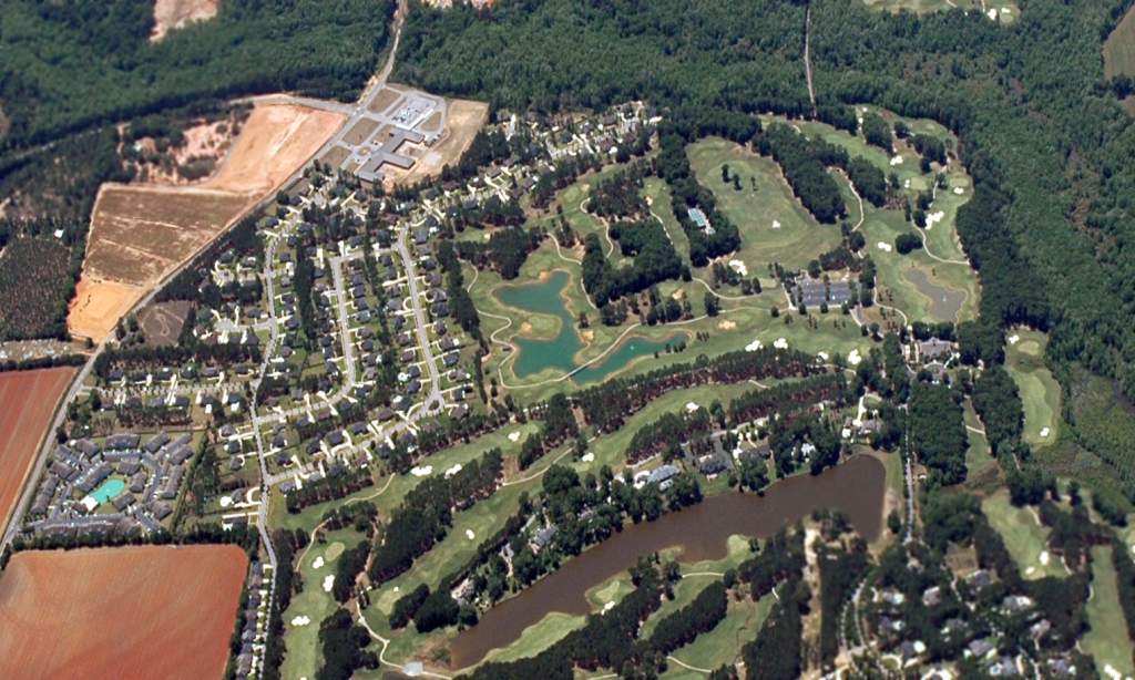
A 5/9/07 aerial view looking south (courtesy of Hugh Wheelless Jr.) of the site of Wheelless Airport “after most of the development was complete.”
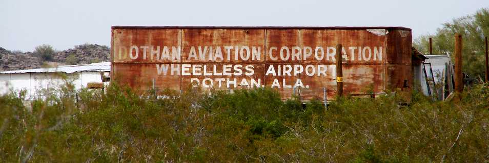
A strange remnant of Wheelless Airport: a 3/8/09 photo of a truck marked “Dothan Aviation Corporation, Wheelless Airport, Dothan Ala.” seen in Enid AZ,
more than a thousand miles away from Dothan, and more than 15 years after Wheelless Airport closed.
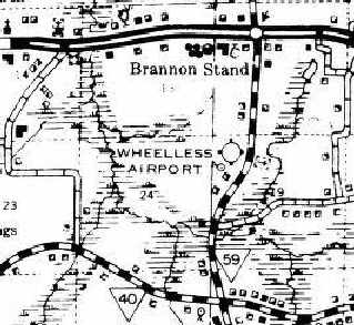
The site of Wheelless Airport is located west of the intersection of Brannon Strand Road & Montrose Court.
____________________________________________________
Dothan Municipal Airport / Napier Army Airfield Auxiliary #2, Dothan, AL
31.24, -85.44 (North of Panama City, FL)
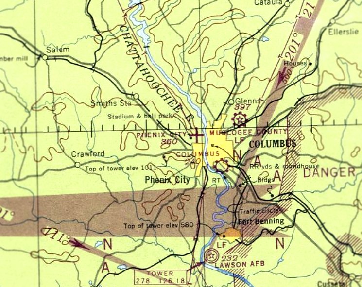
Dothan Municipal Airport, as depicted on the August 1935 Mobile Sectional Chart.
This was the original municipal airport for the town of Dothan.
The date of construction of Dothan Municipal Airport is unknown.
The earliest reference to the field which has been located was in the 1934 Department of Commerce Airport Directory (according to Chris Kennedy),
which described Dothan as having 2 sod runways in an "L" shape, with the longest being 2,100'.
The earliest chart depiction of the Dothan Airport which has been located was on the August 1935 Mobile Sectional Chart.
The Airport Directory Company's 1937 Airports Directory (courtesy of Bob Rambo)
described Dothan Municipal Airport as having 2 sod runways, with the longest being a 2,500' east/west strip.
The earliest photo which has been located of Dothan Municipal Airport
was a circa 1938 photo (courtesy of Frank Gaines) of a Douglas DC-2 making the 1st landing at Dothan by an Eastern Airlines aircraft.
During WW2, Dothan Airport was taken over by the Army, which named it Dothan Auxiliary #2,
and used as one of 4 satellite fields for Napier Army Airfield in Dothan,
which conducted advanced & specialized training in single engine aircraft, including P-40 fighters.
A 2/15/43 aerial view looking east from the 1945 AAF Airfield Directory (courtesy of Scott Murdock)
depicted “Napier Army Airfield Auxiliary #2 (Dothan Municipal Airport)” as having 3 asphalt runways.
The August 1943 17M Regional Aeronautical Chart (courtesy of Chris Kennedy)
depicted Dothan as a military airfield.
The 1945 AAF Airfield Directory (courtesy of Scott Murdock) described “Napier Army Airfield Auxiliary #2 (Dothan Municipal Airport)”
as a 265 acre triangular property within which were 3 bituminous runways, the longest being the 4,000' northeast/southwest & NNW/SSE strips.
The field was said to have a single 80' x 60' steel hangar,
to be owned by Houston County & the City of Dothan, and to be operated by the Army Air Forces.
After WW2, Dothan was returned to its prior use as a municipal airport.
Dothan was depicted as a commercial/municipal airport on the 1949 Mobile Sectional Chart (according to Chris Kennedy).
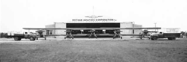
A 1955 photo (courtesy of Virgil Fenn) of 4 Stearman crop-dusters in front of Dothan Airport's Dothan Aviation Corporation hangar.
A 1956 photo (courtesy of Rob Grant) of a Stearman crop-dusters in front of Dothan Airport's Dothan Aviation Corporation hangar.
A 1957 Soil Conservation Service aerial view of Dothan Airport (courtesy of Thomas Kallsen of the University of AL Map Library)
showed at least 12 light aircraft on the eastern ramp.
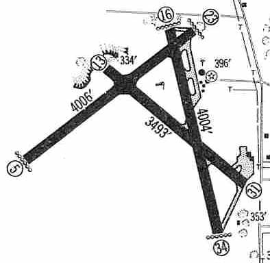
The 1960 Jeppesen Airway Manual (courtesy of Chris Kennedy) depicted Dothan Airport
as having 3 paved runways (with the 4,006' Runway 5/23 being the longest),
along with ramps with hangars on the northeast & southeast sides of the field.
Dothan Municipal was listed among active airports in the 1962 AOPA Airport Directory,
with 3 paved runways, and the operator listed as Dothan Aviation Corp.
It was still depicted as an active airport on the 1964 Mobile Sectional Chart (courtesy of John Voss),
with 3 runways, the longest being a 4,006' asphalt strip.
The last aeronautical chart depiction which has been located of Dothan Airport was on the 1964 Mobile Sectional Chart,
which depicted Dothan as having a 4,000' paved runway.
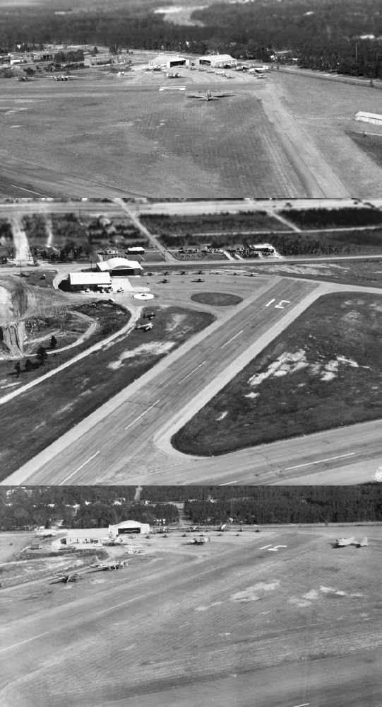
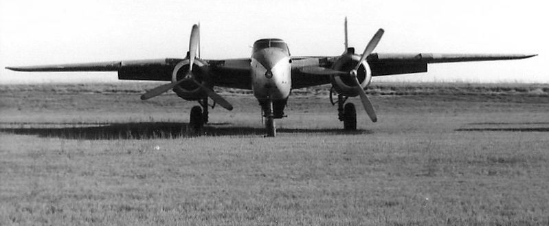
Three 1965 photos (courtesy of Virgil Fenn) of the Dothan Aviation Corporation facilities at the southeast end of Dothan Municipal Airport.
Note the B-25 & B-17 bombers visible in the top & bottom photos.
A 1965 photo (courtesy of Virgil Fenn, restored by Bill Grasha) of B-25 & B-17 bombers
at the Dothan Aviation Corporation ramp on the southeast end of Dothan Municipal Airport.
According to Billy Singleton, Dothan Municipal Airport closed in 1966,
when the City of Dothan completed the rehabilitation of Napier Field for use as its municipal airport.
Napier Field was less constrained geographically, being located farther outside of the town.
In the words of Virgil Fenn, “The city had grown to the edge of the airport & the pressure was on to relocate the airport to Napier Field.”
A 2/5/66 aerial photo showed Dothan Municipal Airport's 3 runways had been marked with closed-runway “X” symbols,
but one aircraft still remained just north of the hangar on the southeast side of the field.
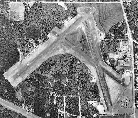
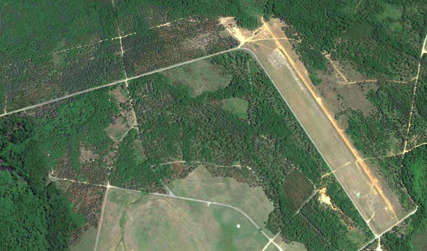
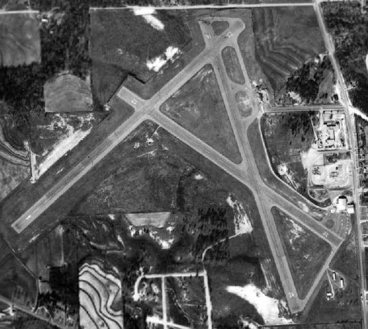
The last photo which has been located showing Dothan Municipal airport still intact was a 1968 aerial view (courtesy of Rob Grant).
The hangars & all 3 runways remained intact, and the runways were still marked with closed-runway “X” symbols.
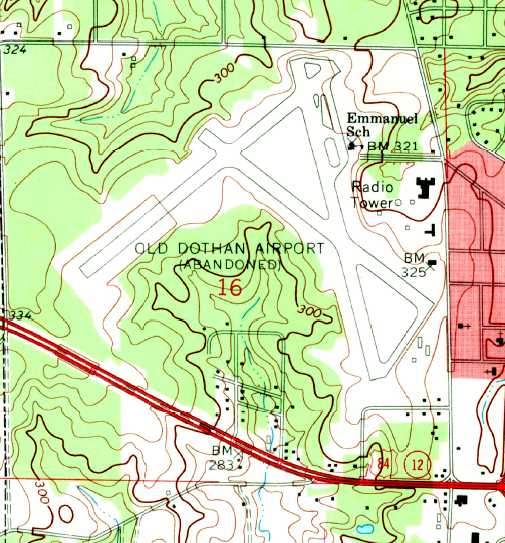
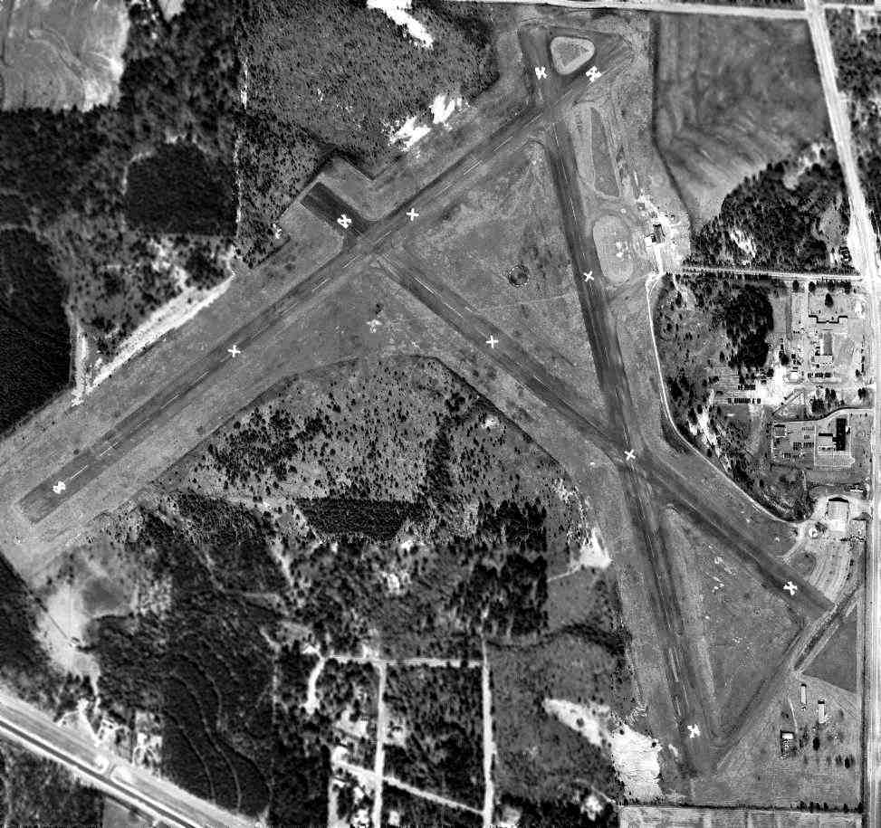
The earliest topo map depiction which has been located of Dothan Municipal Airport was on the 1969 USGS topo map.
It depicted “Old Dothan Airport (Abandoned)” as having 3 paved runways with several buildings on the east side.
John Snapp recalled, "The original Dothan Airport was used as a drag strip in the early 1970s."
By the time of the January 1976 New Orleans Sectional Chart (courtesy of Chris Kennedy),
Dothan Municipal was depicted as an abandoned airfield.

In the 1997 USGS aerial photo the northern portions of the former Dothan Municipal Airport runways still remained evident,
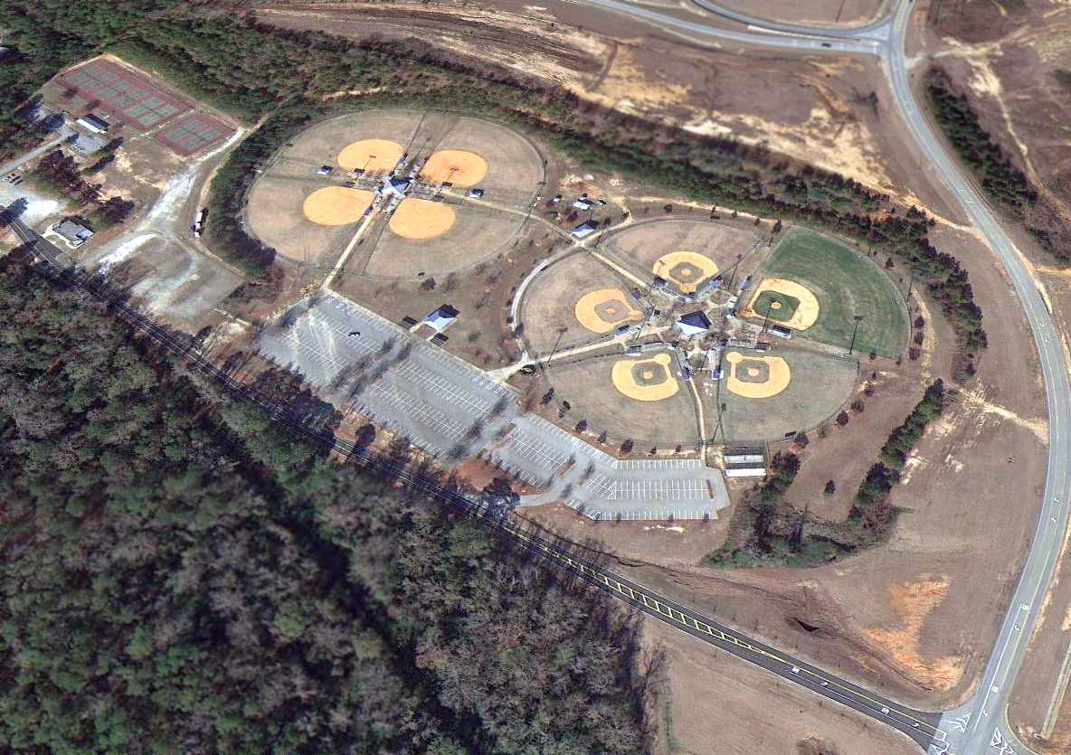
but several baseball diamonds had been built over the southern portions of the runways.
Army aviator Charles Gardner reported in 2007, “The old Dothan Municipal is now the Westgate Recreation Park. I played ball there growing up.
It now is home to a waterpark 'Waterworld', ballfields, and a BMX track.
A few of the old buildings remain at the facility & are used as utility & storage buildings.
Some of the old runway surfaces are still visible & are used as parking for the recreation fields.
I flew over the place while in flight school & you can still see the outlines of an old airport in the middle of the ballfields & tennis courts.”
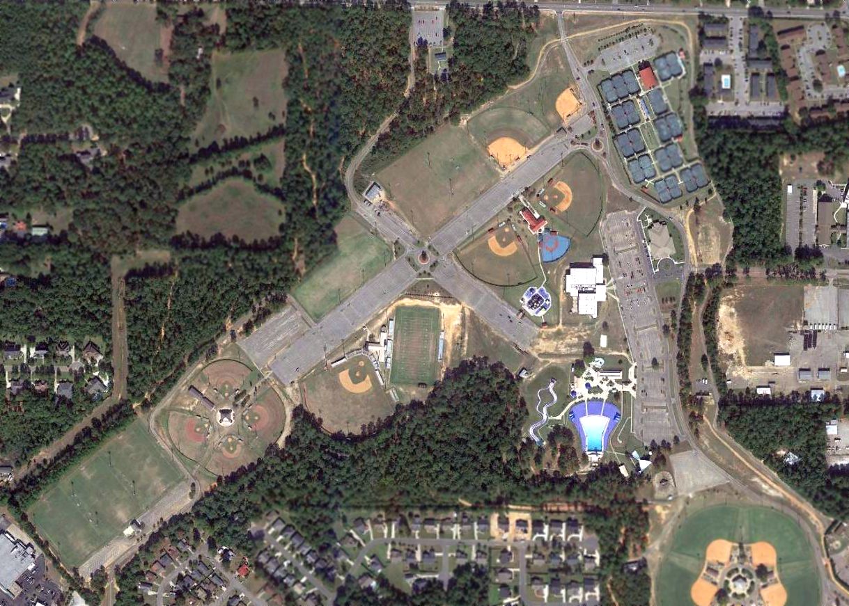
A 2016 aerial photo showed that portions of the former Dothan Municipal Airport's 3 runways still remained evident.
____________________________________________________
Since this site was first put on the web in 1999, its popularity has grown tremendously.
If the total quantity of material on this site is to continue to grow,
it will require ever-increasing funding to pay its expenses.
Therefore, I request financial contributions from site visitors,
to help defray the increasing costs of the site
and ensure that it continues to be available & to grow.
What would you pay for a good aviation magazine, or a good aviation book?
Please consider a donation of an equivalent amount, at the least.
This site is not supported by commercial advertising –
it is purely supported by donations.
If you enjoy the site, and would like to make a financial contribution,
you
may use a credit card via
![]() :
:
Please consider checking the box to make a monthly donatation.
For a mailing address to send a check, please contact me at: paulandterryfreeman@gmail.com
If you enjoy this web site, please support it with a financial contribution.
This site covers airfields in all 50 states.